WeatherHistorian-SeMI

WeatherHistorian-SeMI: Celebrating 29 years - Retired NWS Weather Historian after 37 years, Bill Deedler, continues his thoughts and forecasts on evolving weather patterns and Season Outlooks affecting Southeast Lower Michigan.

Jan 20, 2018

"A GREAT STORM IS UPON MICHIGAN" THE GREAT BLIZZARD OF 1978 - 40TH ANNIVERSARY!

"A GREAT STORM IS UPON MICHIGAN"
THE GREAT BLIZZARD OF 1978!

Written by: William R. Deedler, Weather Historian - Southeast Lower MI

While I worked countless snowstorms in my long career with the NWS; the two most impressive storms were in order: the January 26-27, 1978 Blizzard and the December 1st, 1974 snowstorm. The huge snowstorm of December 1974 was quite noteworthy in the amount of snow that fell continuously for hours over the Detroit Metro area and portions of Southeast Lower Michigan.

A more powerful (in terms of intensity/extent) storm and remains of strong interest to all meteorologists who have studied winter storms in the Great Lakes is the January 1978 Blizzard. This storm is also of interest and remembrance to many longtime residents of the Great Lakes, the Upper Ohio Valley and Ontario, Canada who had to deal with winter's full fury late in January of 1978. In addition, the storm certainly casts many memories for those of us (author included) who were on duty and worked during the storm while observing in tremendous awe the development and subsequent immense strength of this great monster. With the 40th anniversary of this Great Blizzard at hand, it is worth taking a step back in time to re-live this monumental example of nature's fury.

While there are several contenders for the worst blizzard ever to hit the Great Lakes in relatively modern times (since 1870 when records began in Detroit), the immense and intense Blizzard of January 26-27th 1978 must rank at or near the top along with the Great White Hurricane of 1913 with its similar track and powerfulness.

The incredible Blizzard of January 26-27th, 1978 evolved out of a winter that was infamous for cold and storms. The Winter of 1977-78 thus far had been one the coldest, since records began, in many areas from the Rockies eastward to the Appalachians. Mammoth blizzards occurred late in January and early February from the Midwest to the East Coast as strong Arctic plunges dove south into the country and met up with the warmer winds from the deep south. The winter of 1977-78 was similar to its predecessor (1976-77) in terms of cold. The main difference between the two winters, however, came in February. In 1977, temperatures moderated rapidly during February, while in 1978, the cold actually worsened - with several locations reporting their coldest recorded February to date. The Winter of 1977-78 is written down in the record books as Detroit's seventh coldest winter, Flint's fifth coldest and Saginaw's sixth. West of the Rockies, it was a different story as a dominant upper ridge of high pressure provided a relatively mild winter, with some stations even reporting one of their warmest winters on record.

The Great Storm

Since there were some forecasting variances of the intensity and track of the storm, and considering the primitive model of the day (LFM - Limited Fine Mesh), forecasters did an admirable job in forecasting one of the most severe winter storms ever to hit the Great Lakes Region.

A Winter Storm Watch was posted as early as Tuesday night, the 24th, for the southern half of the Lower Peninsula for Wednesday Night into Thursday. Gale Warnings for the Great Lakes were hoisted the following Wednesday morning, along with the Watch. A weaker system had moved through the region earlier during the day on Tuesday and already dropped some snow on the region (a Winter Storm Watch had been issued for this system as well, earlier on Monday, the 23rd). After Tuesday's snow, the headline on the Special Weather Statement that was issued by the NWS Tuesday evening read as follows: "Another Winter Storm Threatens Lower Michigan" and thus, a second Winter Storm Watch was officially posted.

Meanwhile, the ingredients of what would later prove to be a truly fascinating yet vicious winter storm were coming together from different parts of the country. As with the "White Hurricane of 1913," the massive storm actually began as two smaller but distinct storms. A strong low pressure with an attending arctic air mass was entering the Northern Plains by way of Northern Minnesota on Tuesday evening (24th). At the same time, another developing low pressure system was taking shape over the eastern Texas/Louisiana area.
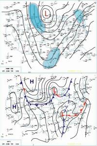
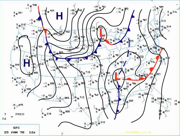
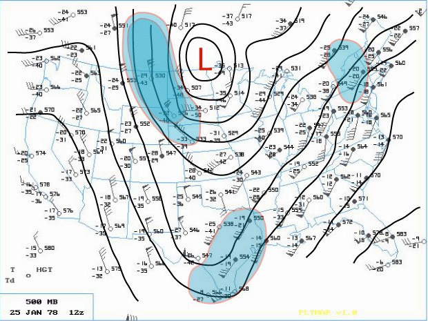
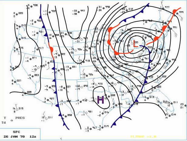
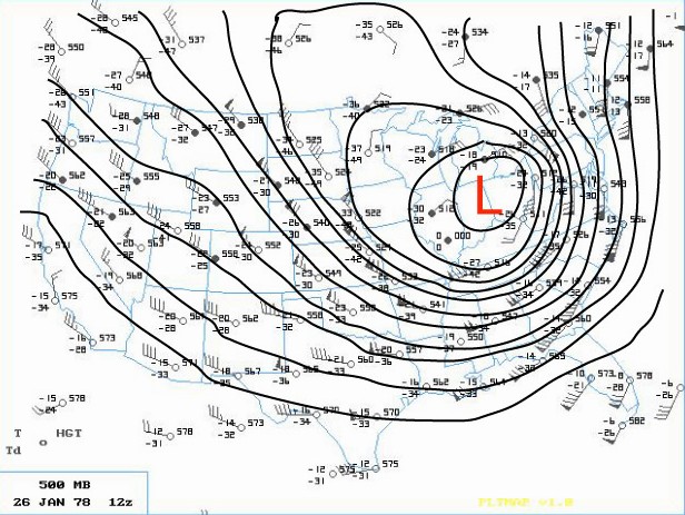
The phasing of two distinct jet streams aloft proved to be the key as to the subsequent strength and massive extent of the storm. A very strong and energetic Arctic impulse surged almost due south and plowed the Arctic front through the Northern Plains late on the 24th. At the same time, another very strong upper wind impulse surged south through southern Arizona. These two jet streaks made up the larger North American jet stream as a huge upper ridge of high pressure along the West Coast of the U.S. diverted the powerful Pacific Jet north into Northern Canada. This northern jet (containing a wind max of 110 knots) then dove due south, like on a giant roller coaster, across the western U.S. as the second, subtropical jet (with an even stronger wind max of 130 knots) surged across southwestern states. On Wednesday (25th), a deepening area of low pressure made its way east across the Gulf States into Georgia by evening (surface | 500mb). Meanwhile, across the north, the Arctic front barreled east across the Upper Midwest into the Western Lakes by Wednesday evening.

Earlier that Wednesday morning, the Winter Storm Watch for Southeast Lower Michigan was changed to a Heavy Snow Warning, while a Travelers Advisory was issued for Western and Northern Lower Peninsula. Later, at the issuance of the evening forecast, the entire Lower Peninsula was upgraded to a Heavy Snow Warning. Meanwhile, a rapid deepening of the surface low over the southeast portion of the country also commenced on Wednesday evening. As the low intensified over Alabama and Georgia, Atlanta registered its lowest barometric pressure ever late on the 25th. At the same time, further north in Michigan, snow was falling over much of the Lower Peninsula. In and around the Ann Arbor and Metro Detroit, the snow mixed with or changed to light rain Wednesday night as slightly warmer air surged northwest into that area ahead of the deepening storm.

While the storm was organizing in the lower levels of the atmosphere over Georgia, the Subtropical and Arctic jet aloft began to merge and phase over the Southeast part of the country. This merging of jet streaks contained a wind max of 150 knots which helped induce a rapid intensification of the Georgia Low as it surged northward into West Virginia early on the 26th. Record low barometric pressures were set all along its path as an ominous track (trough) began to materialize toward the Eastern Great Lakes.

Bands of heavier snow spread north into much of Southern Lower Michigan during the very early morning hours of the 26th. Rain continued to fall, however, over the extreme southeast corner of Lower Michigan. At 1 AM EST, rain was observed at Detroit Metro Airport with the temperature comfortably above freezing at 36 degrees. Further north at Flint, however, sleet and freezing rain were falling as the temperature hovered around freezing. Air pressure tendencies were noted as falling rapidly /PRESFR/ and continued that way for several hours (in fact, several stations in this storms path had to re-adjust their barographs for station pressures traces that were BELOW initial chart scale).

The aforementioned Arctic cold front that was across the Western Great Lakes advanced steadily east into Lower Michigan as the main southern low underwent explosive deepening (this low's central pressure fell 40 millibars in 24 hours)! The central pressure was recorded at 28.28 inches as it tracked north across eastern Ohio, just west of Cleveland, at 7AM EST. As the low moved out over Lake Erie, the Arctic cold front over Southeast Lower Michigan was pulled sharply east into it's mammoth cyclonic circulation. Any residual rain over Southeast Lower Michigan quickly changed to heavy snow and blowing snow during the pre-dawn hours of the 26th. As the Arctic front plowed through the Cleveland area, the wind gusted to an incredible 82 mph! As the Arctic air flooded the Cleveland area, the temperature dropped from a relatively balmy 44 degrees at 4AM EST to a bitterly cold 7 degrees by 1000 AM EST.
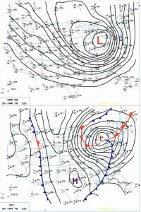
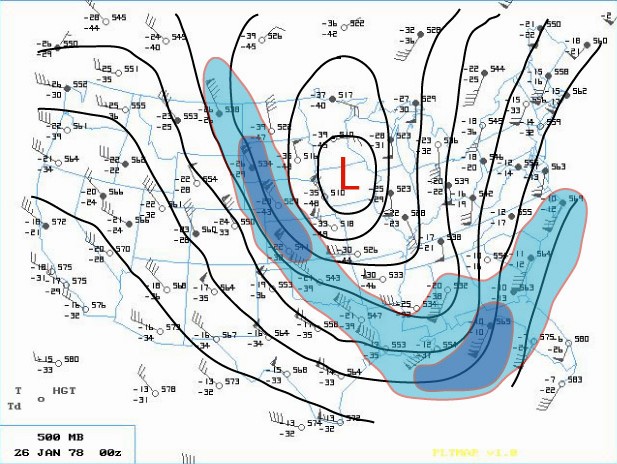
Blizzard Warnings were hoisted across much of the Great Lakes and Upper Ohio Valley Region by daybreak Thursday. The center of the huge storm (surface | 500mb) continued to trek north northwest across Southwest Ontario (roughly between Chatham and London) while Detroit measured its lowest pressure reading at 28.34 inches at 650 AM EST. The incredibly deep center made its way north along the St. Clair River with Sarnia ON reporting the lowest pressure on land at 28.21 inches. Not only was the depth of this mammoth storm's center very impressive, so too was the extent of low pressure from its center. Even locations that were far removed from the storm's center also reported record low pressures. Stations such as Cincinnati OH, Rochester NY and Toronto ON and even as far east as Wilmington N.C., all recorded record low pressure readings from this monster. In fact, at Toronto, where records go back as far back as 1840, the lowest pressure reading of 28.40 inches broke the old record of 28.57 inches by 0.17 inches. In addition, dozens of other cities, with records going back a century, also recorded their lowest pressure reading of all time or, for at least the month of January. This massively intense storm was responsible for strong wind gusts as far away from the center as Boston /72 MPH/ and Chesapeake Bay Bridge /90 MPH/ with even damaging winds reported as far south as Tallahassee FL.

As the Arctic air circulated throughout the storm while it made its way over Lake Huron, the lowest pressure was reached around 950 millibars or a hurricane-like 28.05 inches! "A Great Storm is Upon Michigan" read the headline of the 800 AM EST Special Weather Statement issued by the National Weather Service Forecast Office in Ann Arbor that Thursday /26th/ morning. Heavy snow and blizzard conditions were extensive as wind gusts in excess of 35 mph whipped the snow into huge drifts across much of Southeast Lower Michigan. Other areas of Eastern Michigan, Indiana and Ohio reported near hurricane-force winds, heavy snow and temperatures hovering between zero and 10 above, resulting in extreme blizzard conditions. These conditions later expanded further east into Pennsylvania and West Virginia and prevailed into the night (26-27th) across much of the Eastern Great Lakes, Southern Ontario and the Upper Ohio Valley. With the storm generating copious amounts of snow and very strong winds, whiteout conditions were widespread. All land and air traffic came to a stand still in the affected regions. Several major roads were closed for at least two to three days, if not longer, while clean up got underway. Numerous NWS employees were stranded at work, home, or on the road somewhere between the two. Several employees worked double shifts into at least Friday (some longer) because of the impassable roads with others simply unable to get to work.

The Blizzard Warnings were allowed to die across Michigan during the forenoon hours of Friday, the 27th. Record 24 hour snowfall totals from the storm included, 16.1 inches at Grand Rapids, 15.4 inches at Houghton Lake and 12.2 at Dayton, OH. Snowfalls for the entire storm (25-27th) included a whopping 30.0 inches at Muskegon (some of which was Lake Michigan enhanced), 19.3 inches at Lansing and 19.2 at Grand Rapids. Snowfalls were less over Southeast Lower Michigan (mainly because of the rain that fell for a period) and included 9.9 inches at Flint and 8.2 inches at Detroit.

The following is a quote from the summary written about the storm by Meteorologist in Charge, C.R. Snider on January 30th, 1978 at the National Weather Service Ann Arbor:
"The most extensive and very nearly the most severe blizzard in Michigan history raged throughout Thursday January 26, 1978 and into part of Friday January 27. About 20 people died as a direct or indirect result of the storm, most due to heart attacks or traffic accidents. At least one person died of exposure in a stranded automobile. Many were hospitalized for exposure, mostly from homes that lost power and heat. About 100,000 cars were abandoned on Michigan highways, most of them in the southeast part of the state."
The employees of the National Weather Service Forecast Office in Ann Arbor had just set up shop at the new quarters at the Ann Arbor Federal Building a WEEK before the storm hit. The forecast staff had transferred from the Detroit Metropolitan Airport Office while the observing and radar staff remained at the airport. The majority of employees still lived in and around the metro Detroit area and all major roads between Detroit and Ann Arbor were blocked for approximately 18 hours due to the storm. Several employees put forth efforts beyond the call of duty, stated Mr. Snider in his storm report.

Yet, as mentioned earlier, the Winter was not yet over by any means as the month of February (after the storm) was brutally cold across much of country. The below normal temperature departures of February 1978 were strikingly similar to that of January 1978 (and in some places, February was actually colder). The average temperature for Detroit that winter came in at just 20.5 degrees /normal 27.1/ which again, made it the seventh coldest winter on record. Snowfall totaled a hefty 61.7 inches which made the winter of 1977-78 the ninth snowiest winter on record at Detroit. Flint's average temperature of 19.1 degrees made it the fifth coldest winter on record, but Flint received less snow than Detroit with 50.6 inches. Saginaw's winter average temperature of 17.9 degrees made it the sixth coldest winter on record and was accompanied by 55.6 inches of snow. The 1977-78 snow season at both Flint and Saginaw has since dropped off the top 20 snowiest winters list.

More on the storm in surrounding areas can be found here.

https://www.ncdc.noaa.gov/news/using-regional-snowfall-index-evaluate-great-blizzard-1978
http://www.mlive.com/news/grand-rapids/index.ssf/2017/01/surreal_snow_scenes_from_the_b.html

https://www.youtube.com/watch?v=YuAMWRtT4NY
http://nbc4i.com/2017/01/25/remembering-the-blizzard-of-1978/


Making weather fun while we all learn,
Bill Deedler -SEMI_WeatherHistorian


Posted by WeatherHistorian_SeMI at 3:26 PM 2 comments:
Email ThisBlogThis!Share to XShare to FacebookShare to Pinterest

Jan 14, 2018

A Brief Comparison of Model Performance for Storm Projected Sunday Jan 21st 2018

After my last post on model projections and some wild posts on the internet; I thought it would be interesting to post three model solutions - the /American/GFS, European/ECMWF and the Canadian/GEM each day of the 00Z model projections for the same time period; 00z 01/22/18  (Jan 21st, 2018 Sunday 7PM). Obviously then; model projections will likely change (less hopefully as the time period grows closer) at each successive 00z model run as I post the 500MB position along with the surface for 00z 01/22/18.

All models are projecting some storm with a variety of solutions for the exact time period. Again; the main concern here will be the map projections of the 500 MB jet and associated storm at each day interval for the next week for the time period; 00z 01/22/18. The maps will be from the 00z map projections of all three models with brief comments will be made throughout.


DAY 1; 8 days out (00z - 01/14/18 model run; Sat Jan 13 7PM)

As you note; the postings will be GFS, ECMWF & CMC

1-The GFS has the main low over Northern Indiana, The Euro over Arkansas while the Canadian has placed it over extreme Northern Lower Michigan.

 DAY 2; 7 days out (00z - 01/15/18 model run; Sun Jan 14 7PM)

General trend is slower (this continues on today's 12z also) with storm while high to the NE becoming stronger & more prevalent on most model trends. The Euro has joined the general trend with main low now further north while the GEM is the fastest with the low up in the NW Lakes.
DAY 3; 6 days out (00z - 01/16/18 model run; Mon Jan 15 7PM)

The GFS has basically held the low over E-SE Iowa while weakening it from 993 to 998 MB as the Euro actually backtracked the low to SE Nebraska/NE Kansas and also weakened the low from 990 to 996 MB. GEM has also backtracked the most dropping the low from Northern Wisconsin down to NE Missouri as pressure weakened from 995 to 1002 MB. In actual fairness, it actually elongated the low from Wisconsin down into Missouri with the center in NE Missouri and is similar in position to the GFS.
 DAY4; 5 days out (00z - 01/16/18 model run; Tue Jan 16 7PM)

Interesting how the models subtly shift the low, sometimes similar to the former time-period of another model the day before. All focus has come around to the from the Central Plains/Western Midwest. While the GFS focuses on the Iowa/Missouri area, the Euro remains the furthest sw over E Kansas and the GEM is furthest NW in NW Iowa/NE Nebraska. The GFS hangs on to a 998 MB low intensity while the Euro weakens the low from 996 MB to 1001 MB and the GEM reverses that: deepens the low back to 997 from 1002 MB.

DAY 5; 4 days out (00z - 01/16/18 model run; Wed Jan 16 7PM) and GIF for the the 5 days

Since all models have converged on a Central Plains/West Midwest position and not affect SE Michigan with warm air advection snow; I've decided to end the comparison project with a GIF for each model for the 5 Days running up until 00z Thu, Wed Jan 16, 7PM.


It's very interesting to note the GFS/American model appears to have the least variance for position of the low for the same forecast hour (22/00z Jan 21, 7PM Sun) especially after Day-1. The Euro/ECMWF comes in second while the GEM was all over the place and most variant. However; it must be mentioned that the GIF cycle of the GFS contains all runs (00z,06z,12z,18z) and not just the 00z, while the Euro and Gem contain the 00z and 12z. Therefore, the GFS has the most GIF positions which can be confusing. Comparing just the 00z daily runs of all three models is the best and fairest way to look at it....which was done above for 5 days. Of course, the final analysis won't be available until the Mon, 00z when the initial run for Jan 22, 2018 is done and posted.


Posted by WeatherHistorian_SeMI at 3:15 PM No comments:
Email ThisBlogThis!Share to XShare to FacebookShare to Pinterest

Jan 10, 2018

Winter Storm Brewing - But for Who - Now THAT is the question?

Latest plausible indications continue to push a strong cold front through Southeast Lower Michigan slowly overnight Thursday into Friday morning. Rain with become mixed with/and changes to sleet and then over to snow as the atmosphere column thickens with the colder, snow supporting air. At this time; the front will slide east and southeast as a developing low pressure and storm rides north northeast along the front pushing heavy snow and mixed precipitation through the Ohio Valley and on into the Northeast. In the colder air behind the front over Southeast Lower Michigan; up to a couple of inches are possible on Friday.

Beside the upper air support for the low pressure and storm, it must be noted the High pressure pushing southeast into the northern plains will exude a strong push of Arctic air, once again, southeast into the country. This too will aid in pushing the storm out to the east-northeast. I drew a dotted line as of this writing the snow still could push along that "buffer-zone" if the storm develops faster, high weaker or upper air isn't sampled well enough but the above scenario seems most likely.

Now here's the caveat: model sampling of the atmosphere from upper air, satellite and radar is still not complete as the energy and subsequent phasing is still ongoing. Yes, things can change but again at this time the above seems the most plausible. If dramatic changes evolve from better model sampling and data, I'll surely update.


Finally:
Let me just say; again with some models predicting an Armageddon snowstorm for the Ohio Valley and at times extending into the Southern Lakes, I've stayed out of it with nothing written on it. The crap put on various web-sites pumping an almost certainty fictitious amount of snow for some areas was ridiculous! Those posting 2 or even near 3 foot snowfalls across portions of Southern Michigan into the northern Ohio Valley; especially when many records for 100+ years would be shattered is complete disregard to the general public. I'm not talking about various weather forums that are a mix of all interests...these extreme model solutions hopefully stay with those members, who generally know the "problems" with model output.

Every time there is a hint of a "big" storm, several of these snowstorm enthusiast (spelled N.U.T) start posting the most extreme solutions. Several have questionable educational backgrounds - if any in meteorology - and never even worked in the weather field. And, this happens EVERY winter with the advent of the internet. I can't tell you how many times before and after I retired from the NWS, I was asked: "I heard we are getting this "huge amount of snow" is it true, what do you guys say - and it really has blossomed the past 10 years.

Model forecasting has improved phenomenally in the past 20 years, especially the past 10 but they still get it wrong as all forecasters do. Sometimes during a season, one or two models will have the inside track for accurate forecasting that particular winter - and days out - only to lose it off at times.

I've certainly gotten it wrong on individual events and my Outlooks, nobody is infallible but I try to be reasonable and write various articles and blogs the most objective and limit, to use the in-vogue vernacular -  "Fake News".  Many times when something I forecast is wrong or out of bounds with what happen, I do talk about what went wrong and I wish more would do that because I try to...

Make weather fun while we ALL learn,
Bill Deedler - SEMI_WeatherHistorian
Posted by WeatherHistorian_SeMI at 1:59 PM 2 comments:
Email ThisBlogThis!Share to XShare to FacebookShare to Pinterest

Jan 9, 2018

Early Winter Unfolding Along With Prevalent Analogue Pattern Seen

Officially, we've only been into winter a little better than a month and the cold season /Nov -Mar/ two months. There still is, by historical terms, plenty of winter left - and looking keeping on eye on the hemispheric meteorological patterns and the other on the Winter 2017-18 Outlook issued back in November, can attest to that. After a brutal introduction to 2018 with a continuation of bitter cold temperatures and wind chills; we managed to squeak out a record number of days with temperatures below 20 - twelve days at Detroit and Flint. The old record for Detroit was eleven and was set twice back in 1936 /Jan 23-Feb 2/ and 1979 /Feb 8-Jan 18/. The below 20 streak was tied at Flint with 12 which tied with Feb 8-19 1979. Saginaw did not hold below 20 the entire streak, hitting 21 on the 2nd and thus messed up the record there. More on the cold streak can be found here.

The dominant analogue winters for December were a good predictor for this December in all temperature projections and two out of three snowfalls calling for cold and snowy. Saginaw;'s snowfall came up lower than the higher December snowfall winters but still appreciably above the average.

What is most striking is how close the temperature averages from the analogues for December came  to the actual December 2017 numbers, at all three sites using the colder winter averages added to all the winter averages and dividing by two. I used both numbers; the average of all the analogue Decembers and add that to DOMINANT trend (below normal or coldest Decembers) to get a fair projection for the actual month (see below) which is reflective of the Winter Outlook.

Detroit's temperature analogue data contained a whopping 10 out of 14 below normal Decembers. The average for those 10 winter's came in at 25.6. Even the December temperature average for all 14 winter's came in notably below normal at 27.9 /norm 30.1/. Adding the averages of the coldest December winters and then all the Decembers gives an average of  the two /25.6 + 27.9/ of 26.7. The actual temperature average for December 2017 ironically fell between the two average data projections with the actual 26.6 - just one tenth lower than the average of the two. I'd say the December projection for temperatures was very telling and fits nicely into the other dominant 10 winters (71% of the analogue sample)!

Snowfall projections for December at Detroit were also telling with the dominant analogue December snowfalls having an average of the 7 winters at 18.7". The extremes for December snowfall due to the storm track establishing itself was problematic in the outlook from the start with the range being from 4.3" to 25.1"! However, the pattern of dominant snowfalls (7 out of 14; 50% and 1 December being in the normal range and 6 below normal) did revel itself in the study as likely a snowy December. Actually out of the 7 snowy Decembers, there were 4 where that snowfall averaged around 20" or more...a fairly strong showing in itself and right up there with the 22.5" recorded this past December. That 4 out 8 very snowy winters showed that when there was a snowy December; there was a 50% chance that it would be at least more than double the normal amount /9.7/.

All in all; stepping back to all the dominant; prevailing Decembers in the study for Detroit showed an average temperature of 25.6 degrees with 18.7" of snow...and this past December verified the prevailing pattern.


                                 Detroit Analogue Breakdown For December


Likewise; Flint's average for the all the sample analogue December temperatures came in at 25.4; 1.6 degree below the 27.4 normal. Using the dominant 7 (out of 12) coldest Decembers at Flint gave a projection of 21.6; this compares to Flint's actual December 2017 average of 22.6. Then again; adding both the 25.4 for all of Decembers analogues to the coldest December analogues at 21.6; gives an average of 23.5 Flint's actual temperature came in between the two at 22.6.

Flint's actual heavy snowfall in December followed right along with the heaviest snowfalls in the study. Using the snowiest but not dominant snowfall trends in the analogues finds: the largest snowfalls projected 28.5" out of three very snowy Decembers and well above the normal of 11.8". Flints projected snowfalls in the analogues were much more variable than even Detroit's in December; partly due to the variable placement of the storm track that sets up. It was noted on the Winter Outlook analogue chart that Flint's snowfall for 1910 -11 was highly suspect since both Detroit and Saginaw measured considerable higher amounts (20.1" and 17.4" respectively) as compared to Flints 11.5" so it was not used. Flint's December 2017 snowfall totaled at 23.5" more than double the norm /11.8"/ and almost double the analogue average at 12.8". There is a huge gap between the analogue average and analogue snowiest Decembers in Flint; ranging from 12.8" to 28.5". Looking at the average between the two (12.8" to 28.5") gives 20.6" and not far off the actual total. Even wider were the analogue December snowfalls all together: from 4.4" to 35.3"! Predicting the December 2017 snowfall for Flint was difficult to say the least but still landed in the heaviest snowfall categories like Detroit.

Up at Saginaw gives the following results; the average December temperature for the analogues came in at 25.5; while the average for the below normal or coldest Decembers came in at 21.6. Using the average of the two numbers leads us to the exact number Saginaw recorded in December 2017 - 23.5! Snowfall at Saginaw was the only lacker in the group. The actual snowfall for December did come in above normal with 13.2" /norm 9.0"/ and close to all the December analogue snowfall average at 14.7". But the snowiest Decembers average number was quite a bit higher at 22.1" This was highly skewed by two Decembers with around 40" not unlike Flint.


The overall precipitation thus far this winter has been lacking however with about half of the normal (1.49", -1.33") falling through January 6th. In Detroit's study there were 3 drier than normal winters, 3 wetter than normal and a dominant 8 normal precipitation winters. If we are to have a normal precipitation winter in alignment with the prevailing winters in the study, we're gonna have to step up the precipitation - and recent models indicate as much. While on the subject of future weather; latest indications are that January will make up some of that below normal departure with more moderate to even milder weather at times between long cold spells. This short thaw ongoing is more than welcome for most after temperatures averaged 20 degrees below normal at around 6 at Detroit through the 6th. The first week or so is reflected in the departure map below...

One of the other notable pattern trends of the analogues was the more than average roller-coaster temperature pattern, reflecting the amplified and variable jet. This pattern occasionally locked into the prevailing pattern - cold - but with relief from the cold breaks throughout the winter and early spring. Thus far; there are several analogue years being tagged as similar in our winter pattern thus far with a few very similar.

Next Up: Winter Storm Brewing - But for Who?

After Mid Month - Part Two: A Mid Winter Update - What Do the Best Performing Analogue Winters Thus Far Suggest About the Rest of the Winter and Cold Season?

Making weather fun while we all learn,
Bill Deedler - SEMI_WeatherHistorian


Posted by WeatherHistorian_SeMI at 5:49 PM No comments:
Email ThisBlogThis!Share to XShare to FacebookShare to Pinterest

Dec 20, 2017

The Whitest of Christmases and Other Christmases Past

The Whitest of Christmases and Other Christmases Past 
 
By: William R Deedler; Southeast Michigan Weather Historian
Date: 12PM Wednesday Dec 20th, 2017
 

Frequently during the Christmas Season, meteorologists are asked; Are we going to have white Christmas?  Generally, it is agreed among meteorologists that in order to "officially" have a white Christmas, an average of an inch of snow must cover the ground, but not necessarily have to fall on Christmas. 

At this time /20th/, warmer temperatures and light rain have really did a number on our heavy snow-cover received just last week. Many areas have fallen to just a trace to a few inches. Moderate temperatures the next few days before the straight-out colder weather due Christmas weekend, will continue to slowly eat away at any remaining snow. A system moving across Friday into Saturday may bring some light rain and snow before the cold surges in and then; some light snow and snow showers may fall Christmas eve or Christmas day.  At stage; the likelihood of a white Christmas is questionable even with just the inch of snow necessary to meet the requirement by Christmas morning. Also; as Christmas approaches, early indications very cold air is slated to engulf Southeast Lower Michigan with temperatures estimated to falling into the teens that day.

*Update -  A weak low pressure will move across the southern Great Lakes and northern Ohio Valley and slowly develop over the eastern Lakes into the Northeast. This system will bring mainly light snow to much of Southeast Lower Michigan Christmas Eve and snow showers on Christmas Day along with colder blustery winds. This will provide a white Christmas to the region with generally 2-4" through Christmas. Merry White Christmas!

Over the years, extreme Southeast Lower Michigan has averaged about a 50 percent chance for a white Christmas.  Some years it's already on the ground, some years not, some years it melts while other years it falls on the day. However, theoretically, you could actually have nothing on the ground Christmas morning and have a snowstorm dump a foot on the region during the day and still have NO official white Christmas under the standing morning rule. It works the other way too; you could have a several inches on the ground at 7am 12/25 but warmer air and/or rain melts it away by afternoon or evening and still officially have a white Christmas.

Even with mild weather with temperatures in the 30s; Southeast Lower Michigan was able to hold on to a white Christmas even with last year's moderate temperatures as the snow (generally 2-5") slowly melted. In fact; the day after Christmas, warm air surged into the region and pushed temperatures into mainly the 50s and took care of any remaining snow! Back in December /2015/; it was a mild and snowless Christmas with a high temperatures near 50. Of course, the year before, /2014/ contained our record breaking warm El Nino December, therefore the hopes for a white Christmas were low anyway. Back on Christmas 2014, the chances for a white Christmas were very similar to 2015 with record setting low amounts of snow for the month (in the top 5 snowless). Officially on 12/25/14 at 7am; no snow was on the ground with a trace of light rain on the date. Only a TRACE of snow had fallen up to that day in December /0.1 for the entire month/.  Most areas over the remainder of Southeast Lower Michigan had a few tenths of snow Christmas eve or Christmas but with less than the amount needed and mild temperatures rising into the upper 30s to around 40...none of the area saw a white Christmas. 

Previous recent Christmases:

In 2013;  even with all the snowfall throughout last winter, officially on 12/25/13 at 7am Detroit Metro Airport had only a TRACE of snow on the ground. Most areas into the remainder of Southeast Lower Michigan had some residual snow and ice on the ground for a white Christmas. Back in 2012, enough snow did fall at Detroit Metro Arpt (an inch of fresh snow Christmas Eve) to make it an official white Christmas was on the ground as of 7AM. The necessary inch or more was also on the ground at both Flint and Saginaw. Ironically the day after Christmas, the best snowstorm of the winter season hit the region...a day late and several inches short for Christmas. A year earlier in 2011, it was a relatively mild Christmas with temperatures in the 40s and no snow on the ground; so no white Christmas. However back in 2010; residents across Southeast Lower Michigan did enjoy a white Christmas with generally 1” to 6” of snow across as temperatures hovered in the 20s. Then further back in 2009, much of the Detroit area south did not have a white Christmas but points north across Flint, Saginaw and the thumb region generally had a 1” to 3” snow cover. Back in 2008, we saw a “sloppy, melting white” Christmas. That white Christmas involved the melting of a heavy snow cover from past snows that accumulated throughout December. The best of the snowstorms came before Christmas on the 19th (with another, lesser intense snow falling on the doorstep of Christmas, 23rd -24th). After, however, the heavy snow cover melted in earnest as milder air overspread the region Christmas Eve right through the 26th. Christmas of 2007, saw temperatures rise into the mid 40s to mid 50s a couple of days prior to Christmas and that, combined with light rain, pretty much took care of any hopes for a white Christmas as then, like the later Christmas of 2008, the  previous heavy snow cover melted (but this time in its entirety before Christmas). Some scattered light snow did return, skirting the landscape on Christmas Eve but most areas around Southeast Lower Michigan still only had a trace of snow for Christmas. At White Lake and Saginaw, however, the official inch of snow to make it a white Christmas was barely attained in 2007.

Going back further to the Christmas of 2006; it was also mild and therefore, there was no white Christmas. In 2005, we just barely squeaked out a white Christmas (at Detroit Metro Airport, anyway) as a mild spell moved in just before Christmas along with rain, melting the snow down from 4” to 1” by Christmas morning. Originally, there had been 8” of snow on the ground on the 15th. The last really scenic (no slop)  with fresh white snow for Christmas occurred in 2004. A snowstorm brought heavy snow (ranging from 8”at Detroit to around 4” in Saginaw and Flint) on the 23rd, which left the region with a nice white cover for Christmas. It was also a cold Christmas also with highs only in the teens and overnight lows below zero. 


Looking over historical weather records of Christmases past since 1900, a wide range of weather conditions were found. While most people would like to believe that Christmas in the Detroit area should be snowy-white and picturesque, more often than not, they're not. Over the past 117 (including 1900) Christmases in Detroit, 55 (47%) have been what would be called "white" with an inch or better of snow on the ground. Keep in mind however, these records are for Detroit; farther north in Flint, the chance of a white Christmas jumps to 56 percent, while in Saginaw and the Thumb region it rises to 61 percent.

Based on the Detroit records, the Santa award for the "whitest" (most snow on the ground) and also the second snowiest Christmas (snow falling on Christmas) goes to the Christmas of 1951! Just over a foot /13 inches/ of snow was recorded on ground late Christmas day with 6.2 inches of the snow falling on Christmas. Temperatures held well below freezing (HI-26/LOW-18), so what snow did fall, remained. A close second to the "whitest" Christmas, occurred the Christmas after the big stock market crash in 1929. Eleven and a half inches of snow was measured December 25th, 1929 at Detroit but only three tenths /.3/ fell on Christmas. Recently, the Christmas of 2000 was very white indeed, but as to how much of a white Christmas (snow depths) is where the confusion came in. Let me elaborate, officially at Detroit Metro Airport, just six inches of snow was recorded on the ground at 7AM Christmas Day. However, just about anywhere west/north and in the city of Detroit itself, amounts were considerably higher with generally 8 to at least 15 inches. At the National Weather Service in White Lake, 15 inches was observed on the ground Christmas 2000 morning. No additional snow fell on Christmas Day (nor was anymore really wanted with the surplus already at hand). In any event, for Detroit and surrounding communities, the six inches at Detroit Metro Airport is the official snow depth used for the area.

The snowiest Christmas (most snow falling on Christmas), occurred in 1915 when 6.4 inches fell with a snow depth of seven inches on the ground. The timing of this snowfall was impeccable for Christmas with it actually starting Christmas Eve around sunset. Then, it continued to snow through the night into Christmas day. Actually, even more than the 6.4 inches fell from the entire storm with an additional 1.6 inches falling on Christmas Eve. This gave a snowstorm total of eight inches.  A little light rain did mix with the snow during the forenoon hours of Christmas but with a high temperature of only 33, it did little to mar the "Christmas card" scene. Speaking of "Christmas card" scenes, another heavy wet snowfall blanketed the area just after the turn of the century early on Christmas in 1901. The scene is described in the historical weather books as follows:


    "Night of the 24 - 25 cloudy; moist snow continued,
     heaviest between hours of 1:30 and 4:30 am, ended
     at 6 am. amount of precipitation .62 inches. The
     street cars ran all night to keep the tracks open.
     the snow adhered to trees etc, and made a very
     beautiful scene. Depth of snow on ground at 8 am,
     5.5 inches".


 This "Norman Rockwell Christmas scene" was further enhanced by a heavy coating of frost deposited on the buildings and windows Christmas Eve due to the moisture-laden air. But just like memories of some Christmases past, this majestic Christmas scene quickly faded (melted) during the day as temperatures climbed to 41 degrees, leaving just slush , slop and water. During the Christmases of 2002 and 2003, the weather was similar to both of the white Christmases mentioned above /1901 & 1915/. Here again in 2003, snow started falling Christmas Eve and lasted into at least part of, if not all of Christmas Day. On Christmas Day 2003, snowfalls ranged from at least an inch in the far southeast corner of Lower Michigan to as much as six inches across Detroit's northern suburbs, extending northward across Flint and Saginaw. On Christmas Day of 2002, total snowfall at Detroit Metro Airport was measured at 6.4” inches for both days (Christmas Eve and Christmas) with 3.4” of it falling on Christmas Day, itself. Across all of Southeast Lower Michigan snowfalls generally ranged from four to seven inches. A picture perfect Christmas was created both years with the freshly fallen snow. Like the Christmas snowstorms of 1901 and 1915, the snow Christmas 2002 was also somewhat heavy and wet with high temperatures in the lower 30s and lows only in the mid 20s.

Probably one of the slushiest and sloppiest Christmas Days happened in 1973. What started out as a white Christmas with a heavy 7 inch snow cover, quickly melted to a meager 2” slush mess by nightfall. To add insult to injury, it rained nearly a half an inch during the day.The wettest Christmas on record occurred in 1945 when 1.16 inches of rain fell. The rain actually began Christmas Eve as a light freezing rain and continued freezing until nearly dawn on Christmas, when the temperature pushed above freezing. Until the ice melted, a few tenths of an inch of ice coated everything by Christmas dawn. Needless to say, walking and driving early the Christmas of 1945 was treacherous but Santa was in and out of town in a flash!

Without a doubt, and still in the memories of long term inhabitants of Southeast Lower Michigan, is the warmest Christmas on record, the Christmas of 1982. It was as though the whole area was shipped to Florida for the holiday! The official record high at Detroit was 64 degrees, while Flint did one degree better at 65! These readings are about normal for Tallahassee, Florida! Scenes of shirt sleeved people with shorts running or riding bikes, instead of visions of sugar plums, made the Christmas of 1982 to some Michigan Christmas traditionalist, very hard to take.  This spring-like day was complete with scattered showers and, of all things, thunderstorms! Ironically, the bitterest cold Christmas came just a year later in 1983! Maybe a payback from Mother Nature for the warm weather we were treated to, the Christmas past? The temperature plummeted Christmas eve to a record low of -9 at Detroit and was accompanied by a stiff west wind averaging 25 to 30 mph, creating life threatening wind chills at times of near 40 below zero! Santa certainly brought the North Pole with him the Christmas of 1983, when he made his rounds very early that morning. In addition to the record low Christmas eve, another record low /-10/ was established during the very early morning hours of Christmas.

These Christmases past discussed are more the extreme than the norm across extreme Southeast Lower Michigan. But they do show the variable weather that can occur at Christmas (or any other time for that matter). The "normal" (or average) highs in extreme Southeast Lower Michigan Christmas Day are in the lower 30s, while lows average in the upper teens.

And now, I'd like to wish all who read this a very Merry Christmas and/or Holiday Season and the best in 2018! I plan on continuing my blog for the new year if the fates allow and look forward in reaching out to more people (and hear their comments and ideas) across the globe.

Making weather fun while we all learn,
Bill Deedler - SEMI_WeatherHistorian

Posted by WeatherHistorian_SeMI at 12:45 PM No comments:
Email ThisBlogThis!Share to XShare to FacebookShare to Pinterest

Dec 12, 2017

Another Day...Another Clipper? However: there are differences this time...Including Update

12/13/17 - 300PM

Epilogue:

The forecast and clipper system behaved very well. In fact; the anticipated strengthening deeper than even the models projected came to pass with the central pressure diving to 992-994 MB. On much of the the 12z guidance 12/12/17, central pressure was deepening to around 996-997 MB. Snowfall forecast overall also went well issued 245 PM. Nit picking; I could have said areas of 8" and isolated higher amounts but I'm happy with the overall forecast outcome.

From original forecast below;

"This system has all the ear-marks of a possible over-achiever in the latest guidance compared to  
the earlier runs. All models are leaning toward a bit of a wetter system considering the classic clipper system. This has me concerned and as we have seen; the past few have been achievers-overachievers. The Great Lakes are wide open which won't hurt and the dynamics /vorticity/ projections were notable and getting even stronger".

"At this point the max amounts of snow may very well be in the 6" to pockets of 8" totals with 3-6" encompassing that area."


Snowfall Map below: Courtesy of the NWS DTX


 Individual amounts and more can be found here

-----------------------------------------------------------------------------------------------------------

12/12/17 - 245PM

More snow will move into Southeast Lower Michigan during the forenoon hours of Wednesday. Generally speaking this system appears to have more "uumph" with it than the last one. Simply meaning; depending you location, the same or better amounts of snow than Monday night's & gusty winds while it's falling. In addition; the band of snow will orientate Northwest-Southeast as it moves into the region before leveling off again west-east like Monday night.

At this point the max amounts of snow may very well be in the 6" to pockets of 8" totals with 3-6" encompassing that area. Points further north-northeast will see the least with this system in the 1-4" range. I see no reason to deviate with the models upping amounts seeing the upstream wave impulse and projected track. This system has all the ear-marks of a possible over-achiever in the latest guidance compared to the earlier runs.

The main models are in remarkable agreement on the general snowfall with a snow to water equivalent averaging 2.0"/.15". I believe that's a bit low as the the environmental air initially is quite cold and dry; a 15/1 to 20/1 (2.0"/.10") doesn't seem too outrageous. Then however, one must account for evaporational cooling initially and moistening/saturating the column of air before the snowfall can accumulate much. All models are leaning toward a bit of a wetter system considering the classic clipper system. This has me concerned and as we have seen; the past few have been achievers-overachievers. The Great Lakes are wide open which won't hurt and the dynamics /vorticity/ projections were notable and getting even stronger.

Since the models are very close with this system and they look reasonable at this time with the track; I've decided to post the snowfall amounts generated by some of the pertinent ones. One caveat in the forecast would be main the track and its deviation from the track forecast. Further north, less snow south, more snow north; further south, less snow most areas except near Ohio border. Also of course; true available moisture and speed at which she tracks.will also affect the outcome.


 GFS                                   CAN      


3K NAM                              NAM                                      


Weatherhistorian_SEMIMaking weather fun while we all learn,
Bill Deedler - SEMI_WeatherHistorian


Posted by WeatherHistorian_SeMI at 2:59 PM 10 comments:
Email ThisBlogThis!Share to XShare to FacebookShare to Pinterest

Nov 18, 2017

Winter 2017-18 Outlook for Southeast Lower Michigan - Some surprises along the way?

While the past several months have had some notable weather; to a large extent the summer into mid autumn was fairly tranquil with just the occasional upset in the pattern. We are beginning to see a busier and more contrasting and subsequently, conflicting pattern rev-up as we head into the latter part of the year. What's been somewhat gratifying yet a bit uneasy for me is how well the present mid fall pattern fits into the upcoming winter pattern I found for this; my 21st Winter Outlook.

Some changes in my Outlook are in store for the beginning of my third decade of season outlook forecasting. They include an even more thorough analogue chart including previously mentioned patterns in the past such as: Arctic Oscillations, Solar and QBO cycles along with Siberian/Eurasia October snow cover (available since 1998) during the previous analogue winters. This in turn is compared to the upcoming Winter of 2017-18's observed or projected patterns. Therefore, much of the information discussed is there for the reader to quickly scan on the chart. I still will provide a brief summary of each indicator but limit the amount of description, while still occasionally connecting the reader to the corresponding website. The overall, Winter Outlook format remains the same as presented in the past. Now on to the Outlook...


Winter Outlook for the Winter of 2017-18 

Occasionally in my past Winter Outlooks, I've eluded to Mom Nature 'tipping her hand' as to what the upcoming winter will bring. This appears to be the case this time as one casts one eye on the recent autumn pattern change and the other eye on this winter's analogues and general upper and surface weather pattern - which actually agree strongly with computer guidance. Of course, sometimes even though the overall general pattern verifies well; the final winter statistics may differ from the forecast - this too I could easily see being the outcome with this winter's projected pattern with the wild fluctuations.


Local Data Suggests 


Temperatures: Normal to Below 


Expect temperatures during the 2017-2018 winter to be quite changeable as opposing air masses vie for dominance under a fluctuating jet stream. This is not only a developing trend seen the past month or two but it's well displayed in the Winter Analogues for 2017-18 and finally; the computer guidance for the upcoming winter. While this is a typical La Nina pattern, my research shows and I believe again this winter the Pacific jet will be more of a key player against the typical La Nina pattern. The basic difference this winter from last winter is all data that I research is intimating a notably colder winter than last winter. This is likely due to a preponderance of polar/arctic air masses.

In the final analysis, I look for the Southeast Lower Michigan winter to average around normal to below normal.  The outlook for temperature departures will be of a wider range than generally forecast; averaging from -3.0F to +1.0F.

Precipitation: Above


Because of the parade of conflicting air masses diving in from the north and west, with temperature variability and associated storms and storm tracks ignited; above normal precipitation is likely for the Winter of 2017-18. This trend is supported by many of the analogue winters, along with model output for the winter and recent autumn trends. With the discussed storm tracks below; mixed precipitation is at a higher risk this winter. I do look for the alternating extended wet and dry periods to persist into the winter from the autumn.

Snowfall: Around Normal to Above 


The especially tricky part of this forecast is how much of the expected precipitation will be snow and/or mixed precipitation? In the analogues: snowfall in the winters ranged widely from above normal to below. This would be expected since the variance of temperatures hint at the variability of the upper atmospheric patterns and storm tracks. Therefore, pinpointing the perceived prevailing storm tracks this winter will make a significant difference in regard to seasonal snowfall. This is similar to last year's La Nina and is strongly suggested in model output. Remember; an above normal precipitation winter does not necessarily mean above normal snow...even with a colder winter! It's been awhile since we've had a cold winter but with below normal snowfall. The state of the atmosphere when the precipitation becomes available is the key and this looks especially relevant this winter. Leaning on the analogues; I look for generally normal, or an average winter's snowfall (+/- 5" of the norm) across much of extreme Southeast Lower Michigan. This is a winter however where below normal snows could certainly occur especially in this area if the storm track rides further north. The better chance for above normal snow expected further west and north away from that region. Therefore; best chance for above normal snow will lie in an arc from the Brighton/Howell area /I-96 area/ east northeast across Flint and Port Huron /I-69/ and points north/northwest into the Saginaw Valley/Thumb Region.

Below Normal snowfall; less than /- 5.0"/ of the winter average snowfall  
Normal snowfall; +/- 5.0" of the winter average snowfall
Above Normal snowfall; better than /+5.0"/ of snow above the average.


Hemispheric Discussion 


In case you haven't surmised by now; the upcoming winter is expected to be, like last winter, a La Nina winter. In addition; this winter's La Nina is likely to be generally similar in strength to last year's; albeit possibly a bit stronger and may reach borderline moderate at -1.5 departure. I also look for this winter's La Nina to have more of an influence on our weather than last winter's; mainly due to the atmosphere's stronger resultant La Nina pattern reaction (not dominant last winter) along with the cool Pacific Decadal Oscillation in place.


 ENSO Regions in the Pacific


Current ENSO SST anomalies as of mid November


Current ENSO map conditions as of mid November


The Oceanic Nino Index /ONI/ 1950 - mid 2017 below; shows all the El Nino's and La Nina's strong and moderate - weak are not depicted except for last winter's.

  ONI


 SOI


The Southern Oscillation Index /SOI/ below shows well the recent negative corresponding values in conjunction with our recent strong El Nino of 2015-16. Remember; an above normal SST is reflective of a negative SOI. This comes into play especially pre-1950 for analogue research.


North Atlantic/Arctic Oscillation - NAO/AO 

Most winters; the phase of the NAO/AO is one of the most important ingredients to the type of winter to be-had over the central and eastern part of the country; and even parts of the mountainous areas of the west at times. This is one of the most elusive oscillations to predict for more than a week or two out.

SNOW-COVER 

One of the newer studies uses October snow-cover over Siberia/Eurasia to aid in projecting out the main phase and likely corresponding temperature pattern for the winter. In my analogues; I've included this past October's coverage (and looking at the rate of coverage) that has been researched since 1998. In the analogues; you will notice minus signs and a plus sign for this October. Simply put; this October had the most snow-cover over that region for all the analogue years. The analogue years since 1998 are less than this year /-/ and this October is /+/ for the greatest relative to those analogue years. As a matter of fact; this past October 2017 had one of the snowiest overages by the end of October relative to any year since 1998 with only a few non-analogue years that equaled it. This study suggests a more -NAO/-AO likely to prevail this winter and thus; colder temperatures (see map below). The research and up to date discussions can be found here on Dr. Jonah Cohen's pages.

Mr. Cohen has a nice update here every week on current and expected trends.


From his discussion 11/20/17...

"October Eurasian snow cover extent was above normal, Arctic sea ice extent is well below normal and will continue to be below normal for the entire winter.  Also, strong blocking was observed this fall across the high latitudes.  All three factors favor colder temperatures across at least parts of the Northern Hemisphere (NH) mid-latitude continents during the winter months".

  Snow-cover as of Nov 20th 2017


Pacific Decadal Oscillation /PDO/ and associated subset EPO


The previous warm phase Pacific Decadal Oscillation recently switched to a cool phase this year. A cool phase of the PDO is represented on the right of the following example and compare it to the current state.


                             Warm Phase of the PDO                    Cool Phase of the PDO


The recently evolving cool phase of the PDO and weak La Nina are displayed well in this recent Global SST scan on November 16th, 2017. 


Generally warm phases coincide with El Ninos or Neutral states and rarely La Nina states while cool phases coincide with La Ninas, as in the present state. Studies propose that when the PDO and ENSO are out of phase; which is a somewhat rare event, that they may cancel out their known effects. This isn't expected to happen during the upcoming winter.

"When SSTs are anomalously cool in the interior North Pacific and warm along the Pacific Coast, and when sea level pressures are below average over the North Pacific, the PDO has a positive value. When the climate anomaly patterns are reversed, with warm SST anomalies in the interior and cool SST anomalies along the North American coast, or above average sea level pressures over the North Pacific, the PDO has a negative value" (Courtesy of Mantua, 1999).


Recent PDO values 


YYYYMO VALUE
201612  0.55
201701 0.10
201702 0.04
201703 0.13
201704 0.52
201705 0.29
201706 0.18 
201707 -0.54 *
201708 -0.64
201709 -0.26
201710 -0.60


*The notable change from positive to negative values are shown

"The Pacific Decadal Oscillation (PDO) is a pattern of Pacific climate variability similar to ENSO in character, but which varies over a much longer time scale. The PDO can remain in the same phase for up to 20 to 30 years, while ENSO cycles typically only last 6 to 18 months. The PDO, like ENSO, consists of a warm and cool phase which alters upper level atmospheric winds. Shifts in the PDO phase can have significant implications for global climate, affecting Pacific and Atlantic hurricane activity, droughts and flooding around the Pacific basin, the productivity of marine ecosystems, and global land temperature patterns. Experts also believe the PDO can intensify or diminish the impacts of ENSO according to its phase. If both ENSO and the PDO are in the same phase, it is believed that El Niño/La Nina impacts may be magnified. Conversely, if ENSO and the PDO are out of phase, it has been proposed that they may offset one another, preventing "true" ENSO impacts from occurring". 


http://jisao.washington.edu/pdo
http://www.john-daly.com/theodor/pdotrend.htm


Last winter, the ENSO (La Nina) and PDO (warm phase) were out of phase and the winter was indeed notably warmer than what is generally seen in a La Nina winter. This was mentioned in last Winter's Outlook and one of the reasons noted that may interfere with the normal LA Nina winter jet and temperature pattern.


SOLAR CYCLE /SC/

Solar cycle actual effects on short term weather and longer term climate variability remain a controversial subject. I've read several articles which support or are against their shorter term winter relevancy. Some theorize that both natural solar cycles and man's influence affect our climate. I am in favor of the solar cycle being somewhat relevant and sometimes giving the present winter cycle a "little kick" in regard to hemispheric wind flow patterns and resulting temperatures.  Numerous recent studies for example, do in fact make the connection to our climate and solar activity including wintertime effects. One of the studies stated the following:

"The Euro–Atlantic sector seems to be a region with a par-
   ticularly strong solar influence on the troposphere. In fact,
significant positive correlations between solar activity and
  surface temperature in Europe have been reported in several
 papers (e.g. Tung and Camp, 2008; Lean and Rind, 2008;
 Lockwood et al., 2010; Woollings et al., 2010), although
  long records tend to give very weak signals (van Olden-
   borgh et al., 2013). We found a weak but significant change
     in the mean late winter circulation over Europe, which re-
   sults in detectable impacts on the near-surface climate. Fig-
   ure 9 suggests that during solar minima more cold air is ad-
   vected from the Arctic, thus resulting in a slightly increased
 probability of colder winters for large parts of the continent.
 Sirocko et al. (2012) recently reached the same con-
 clusion after analyzing 140 yr in 20CR, although their results
are strongly dependent on their selection criteria for
  the solar minimum composite (van Oldenborgh et al., 2013),
    which includes only one winter for each solar cycle".


Comparing solar cycles of the past analogue winters to the present as a possible influence only and not a major contributor. While the solar cycle was in various modes, the tendency is for these La Nina's to Neutral winters to occur during the mid to lower part of the cycle or during an overall, weaker cycle (like the ones we have entered below on the Sunspot chart - only three winter's at opposite ends of the solar sunspot spectrum were noted in our La Nina analogues.

Recent Sunspot chart since the new millennium


Longer Term Solar Sunspot Activity since 1849 (includes the Winter Analogues)


 THE QBO INFLUENCE


The QBO, or Quasi-Biennial Oscillation, is an oscillation in the wind direction in the stratosphere within about 15 degrees of the equator. Over a roughly two-year period, winds tend to oscillate between westward and eastward, with the switch between west and east winds starting high in the stratosphere and then shifting lower in altitude with time. The QBO is the result of waves propagating vertically in the atmosphere that then interact with the mean flow to slowly change wind speeds and direction. These changes influence the overall global circulation patterns, which in turn influence winter weather patterns across North America. 


The amplitude of the easterly phase is about twice as strong as that of the westerly phase. At the top of the vertical QBO domain, easterlies dominate, while at the bottom, westerlies are more likely to be found. At the 30mb level, with regards to monthly mean zonal winds, the strongest recorded easterly was 29.55 m/s in November 2005, while the strongest recorded westerly was only 15.62 m/s in June 1995 (Wikipedia).

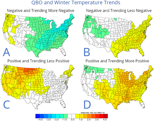
If you notice on my analogues; I included the QBO's for each available winter and compared it to the upcoming winter's QBO phase and trend. The present and expected QBO this winter is for an easterly QBO (recently switching from west since the summer shown below as a negative wind speed) and also increasing in amplitude. The set of maps below show the differing influences of the QBO dependent on phase and trend.The QBO is presently in the negative and trending more negative phase (first map).


Recent Monthly QBO Data for 2017 through October

2017:     14.92   14.78   14.35   13.88    8.01   -3.18  -10.48  -14.42  -15.28  -16.79


QBO and WinterTemperatures Trends


WINTER 2017-18 ANALOGUES - SOUTHEAST MICHIGAN


                        CLICK ON TO ENLARGE


 Some additional category explanations in the analogue chart from left to right

AO/SC

AO - The predominant phase of the Arctic Oscillation during that winter. AO- (negative), AOn   
         (neutral) or AO+ (positive).
SC -  position of the solar cycle during that winter. Breaking it down (see solar cycle chart):   
          SC-- (opposite high cycle compared to the present, least similar) SC+/- (sunspots 
          waning but not near minimum or 2017 low level. Finally, S++ where solar sunspot cycle is  
          at or very close to the low cycle of 2017 and/or is at the same decline with 2017...the   
          best comparison and likeness.
          
QBO - W=West wind prevailed that winter or E=East wind prevailed. Trends: -/- (weak and    
            weakening trend), -/+ (weak but strengthening), s (steady trend, no change) +       
            moderate and strengthening +/- strong but weakening. Note that the trend now in the fall  
           of 2017 is E/+, a moderate east wind and still strengthening. This fits with all the winter's
            that contained a easterly QBO. Those winters were the Winter of 1917-18 (also  
            increasing),  1950-51 (weak and weakening further), 1984-85 (strong but weakening), 
           2000-01  (moderate  easterly and steady) and finally 2011-12 (weak but increasing).  

Sib snow - Siberian snow cover in October and rate of change. All previous analogues winters
                  had less snow cover than this past October's. There have been a few winters not in
                  the analogue list that had roughly equal to and one of two that had more snow cover
                  but a clear majority had less snow cover.

WINTER ANALOGUE SUMMARY 


Temperatures 

One of the first things one notices about this winter's analogues is the wide-ranging temperatures and snowfalls. That is clearly NOT surprising; one look at the dominant atmospheric players for the winter, the subsequent jet streams and storm tracks explains exactly why the variable analogue results, in spades. This winter will not be a clear-cut La Nina influenced; mainly because of the influential strong Pacific jet tempering results at times. This shows up mainly in the variable jet stream/storm tracks, temperature patterns and resulting snowfall amounts. As an example; though on average Decembers averaged below normal, there were still a notable amount above /Detroit; 4 out of 14/ all in the later years since the 1970s. At the same time; if the Decembers were mild, then the Januarys were generally cold or below normal. Looking across the board at the three cities, there were a predominance of normal to below normal winters (also my forecast) with a few above normal. Generally; these winters were early to middle loaded with the preponderance of storms roughly from mid December into mid February with later winter, average to below. However; colder weather tended to hold on into at least early spring...not surprising in these parts. By the way; severe weather buffs should note that the spring looks to be busier than the past several years.


Precipitation


Total precipitation and snowfall also widely ranged from below to above. However; a definite trend was seen in normal to above precipitation (matching well with all guidance, La Nina winters on average and recent trends) while a dry winter was least likely. There again though, there were enough drier winters that made a showing not to eliminate that possibility. With the storm tracks created this winter (see below); the risk of mixed precipitation is higher.  In other words: a normal to below normal temperature winter with below normal rain and snow is not out of the question reflecting back in previous analogue years...and it's been a while since we've had a "cold but relatively dry winter". 


Snowfall

The snowfall category by itself is quite interesting with a wide amount of snow totals and where those snow amounts fell.  First off; it was close to an even split for below, normal or above normal snowfalls across the Southeast half of our concerned region. This area extends from the Flint to Port Huron area; south to the Ohio border. There were significant below normal snows ranging in the 20s (inches) across Detroit and 20s and 30s into Flint, constituting a good third of the sample. On the higher side of normal; there were just as many above normal snowfalls into the 50s and 60s around the Detroit region and 50s to even a few in the 70s across the Flint region. I'm sure the reader here can see why snowfall for a season can be such a tough call...and where.


The only region where snowfall truly showed a trend (above) was across the northern third of Southeast Michigan; the Saginaw Valley and Thumb region. This are had 7 above normal snow winters and 4 normal - there were no below normal. Above snowfalls ranged from around 50" into the 70s. In fact; the average snowfall for the analogue winters at Saginaw was a foot above normal. Where as Detroit and Flint settled in the normal range.


Below are the maps from the analogue winters for Temperature departures, 500MB Low placement and subsequent likely storm track placement (Dec-Mar). Note the time period encompasses March also (still a winter month in my book)


TEMPERATURES 


 500 MB LOW PLACEMENT


STORM TRACK PLACEMENT 


 Latest Model Output for the Winter of 2017-18 with a few surprising models.

CFS /American/

TEMP
 PCPN

ECMWF /EUROPEAN/

TEMP


PCPN

UKMET /BRITISH/

TEMP
 
PCPN


METEO FRANCE 

TEMP
 
PCPN


Look for more write-ups through the winter involving notable weather events, major storms and comparing the Winter Outlook trends and actual weather trends!

Making weather fun while we all learn,
Bill Deedler - SEMI_WeatherHistorian


Posted by WeatherHistorian_SeMI at 4:55 PM 3 comments:
Email ThisBlogThis!Share to XShare to FacebookShare to Pinterest
Newer Posts Older Posts Home
Subscribe to: Posts (Atom)

Followers

Total Pageviews(Best viewed in Mozilla Firefox or Google Chrome browsers)

About Me

My photo
WeatherHistorian_SeMI
WeatherHistorian_SeMI: Recently retired NWS Weather Historian, Bill Deedler, continues his thoughts and forecasts on evolving weather patterns affecting Southeast Lower Michigan - along with adapting Season Outlooks for Southeast Lower Michigan since 1997.
View my complete profile

Browsers

Best viewed in Mozilla Firefox or Google Chrome

The Oakland Press : Serving Oakland County

WeatherHistorian_SeMI

WeatherHistorian_SeMI: Recently retired NWS Weather Historian, Bill Deedler, continues his thoughts and forecasts on evolving weather patterns affecting Southeast Lower Michigan.

Blog Archive

  • ▼  2026 (2)
    • ▼  June (1)
      • ▼  Jun 02 (1)
        • Cool & Dry May Reflective of the Upcoming Summer's...
    • ►  January (1)
      • ►  Jan 02 (1)
  • ►  2025 (11)
    • ►  December (1)
      • ►  Dec 24 (1)
    • ►  November (1)
      • ►  Nov 16 (1)
    • ►  October (1)
      • ►  Oct 08 (1)
    • ►  September (1)
      • ►  Sep 28 (1)
    • ►  July (1)
      • ►  Jul 21 (1)
    • ►  June (1)
      • ►  Jun 08 (1)
    • ►  April (1)
      • ►  Apr 07 (1)
    • ►  February (2)
      • ►  Feb 15 (1)
      • ►  Feb 02 (1)
    • ►  January (2)
      • ►  Jan 16 (1)
      • ►  Jan 01 (1)
  • ►  2024 (7)
    • ►  December (1)
      • ►  Dec 24 (1)
    • ►  November (1)
      • ►  Nov 27 (1)
    • ►  October (1)
      • ►  Oct 23 (1)
    • ►  July (1)
      • ►  Jul 08 (1)
    • ►  June (1)
      • ►  Jun 06 (1)
    • ►  February (1)
      • ►  Feb 04 (1)
    • ►  January (1)
      • ►  Jan 15 (1)
  • ►  2023 (7)
    • ►  December (2)
      • ►  Dec 24 (1)
      • ►  Dec 21 (1)
    • ►  November (1)
      • ►  Nov 18 (1)
    • ►  September (1)
      • ►  Sep 25 (1)
    • ►  July (1)
      • ►  Jul 10 (1)
    • ►  May (1)
      • ►  May 26 (1)
    • ►  January (1)
      • ►  Jan 25 (1)
  • ►  2022 (18)
    • ►  December (4)
      • ►  Dec 22 (1)
      • ►  Dec 21 (1)
      • ►  Dec 19 (1)
      • ►  Dec 02 (1)
    • ►  November (2)
      • ►  Nov 13 (1)
      • ►  Nov 04 (1)
    • ►  September (1)
      • ►  Sep 17 (1)
    • ►  June (3)
      • ►  Jun 21 (1)
      • ►  Jun 05 (1)
      • ►  Jun 01 (1)
    • ►  May (1)
      • ►  May 08 (1)
    • ►  April (1)
      • ►  Apr 01 (1)
    • ►  February (2)
      • ►  Feb 14 (1)
      • ►  Feb 02 (1)
    • ►  January (4)
      • ►  Jan 31 (1)
      • ►  Jan 26 (1)
      • ►  Jan 23 (1)
      • ►  Jan 17 (1)
  • ►  2021 (8)
    • ►  November (1)
      • ►  Nov 20 (1)
    • ►  September (1)
      • ►  Sep 21 (1)
    • ►  July (1)
      • ►  Jul 14 (1)
    • ►  June (1)
      • ►  Jun 01 (1)
    • ►  May (2)
      • ►  May 27 (1)
      • ►  May 05 (1)
    • ►  April (1)
      • ►  Apr 06 (1)
    • ►  January (1)
      • ►  Jan 30 (1)
  • ►  2020 (12)
    • ►  December (1)
      • ►  Dec 23 (1)
    • ►  November (2)
      • ►  Nov 26 (1)
      • ►  Nov 08 (1)
    • ►  October (1)
      • ►  Oct 20 (1)
    • ►  July (1)
      • ►  Jul 04 (1)
    • ►  June (2)
      • ►  Jun 18 (1)
      • ►  Jun 11 (1)
    • ►  May (1)
      • ►  May 05 (1)
    • ►  April (1)
      • ►  Apr 07 (1)
    • ►  February (2)
      • ►  Feb 23 (1)
      • ►  Feb 04 (1)
    • ►  January (1)
      • ►  Jan 30 (1)
  • ►  2019 (17)
    • ►  December (2)
      • ►  Dec 31 (1)
      • ►  Dec 20 (1)
    • ►  November (2)
      • ►  Nov 19 (1)
      • ►  Nov 12 (1)
    • ►  September (1)
      • ►  Sep 20 (1)
    • ►  July (1)
      • ►  Jul 01 (1)
    • ►  June (2)
      • ►  Jun 21 (1)
      • ►  Jun 03 (1)
    • ►  May (2)
      • ►  May 22 (1)
      • ►  May 05 (1)
    • ►  April (1)
      • ►  Apr 23 (1)
    • ►  February (1)
      • ►  Feb 20 (1)
    • ►  January (5)
      • ►  Jan 29 (1)
      • ►  Jan 27 (1)
      • ►  Jan 24 (2)
      • ►  Jan 13 (1)
  • ►  2018 (19)
    • ►  December (1)
      • ►  Dec 19 (1)
    • ►  November (2)
      • ►  Nov 25 (1)
      • ►  Nov 03 (1)
    • ►  September (2)
      • ►  Sep 23 (1)
      • ►  Sep 10 (1)
    • ►  July (1)
      • ►  Jul 14 (1)
    • ►  June (3)
      • ►  Jun 17 (1)
      • ►  Jun 12 (1)
      • ►  Jun 02 (1)
    • ►  May (1)
      • ►  May 19 (1)
    • ►  April (1)
      • ►  Apr 10 (1)
    • ►  March (1)
      • ►  Mar 31 (1)
    • ►  February (3)
      • ►  Feb 28 (1)
      • ►  Feb 10 (1)
      • ►  Feb 04 (1)
    • ►  January (4)
      • ►  Jan 20 (1)
      • ►  Jan 14 (1)
      • ►  Jan 10 (1)
      • ►  Jan 09 (1)
  • ►  2017 (17)
    • ►  December (2)
      • ►  Dec 20 (1)
      • ►  Dec 12 (1)
    • ►  November (1)
      • ►  Nov 18 (1)
    • ►  October (1)
      • ►  Oct 16 (1)
    • ►  September (3)
      • ►  Sep 26 (1)
      • ►  Sep 20 (1)
      • ►  Sep 05 (1)
    • ►  June (3)
      • ►  Jun 24 (1)
      • ►  Jun 08 (1)
      • ►  Jun 05 (1)
    • ►  May (1)
      • ►  May 08 (1)
    • ►  April (1)
      • ►  Apr 05 (1)
    • ►  February (3)
      • ►  Feb 22 (1)
      • ►  Feb 20 (1)
      • ►  Feb 06 (1)
    • ►  January (2)
      • ►  Jan 30 (1)
      • ►  Jan 22 (1)
  • ►  2016 (30)
    • ►  December (4)
      • ►  Dec 20 (1)
      • ►  Dec 16 (1)
      • ►  Dec 12 (1)
      • ►  Dec 02 (1)
    • ►  November (1)
      • ►  Nov 20 (1)
    • ►  October (3)
      • ►  Oct 31 (1)
      • ►  Oct 18 (1)
      • ►  Oct 03 (1)
    • ►  September (4)
      • ►  Sep 19 (1)
      • ►  Sep 07 (1)
      • ►  Sep 01 (2)
    • ►  July (1)
      • ►  Jul 10 (1)
    • ►  June (3)
      • ►  Jun 30 (1)
      • ►  Jun 16 (1)
      • ►  Jun 03 (1)
    • ►  May (2)
      • ►  May 27 (1)
      • ►  May 11 (1)
    • ►  April (3)
      • ►  Apr 30 (1)
      • ►  Apr 27 (1)
      • ►  Apr 01 (1)
    • ►  March (1)
      • ►  Mar 09 (1)
    • ►  February (5)
      • ►  Feb 29 (1)
      • ►  Feb 23 (1)
      • ►  Feb 22 (2)
      • ►  Feb 08 (1)
    • ►  January (3)
      • ►  Jan 29 (1)
      • ►  Jan 24 (1)
      • ►  Jan 09 (1)
  • ►  2015 (37)
    • ►  December (3)
      • ►  Dec 26 (1)
      • ►  Dec 19 (1)
      • ►  Dec 09 (1)
    • ►  November (3)
      • ►  Nov 18 (1)
      • ►  Nov 15 (1)
      • ►  Nov 01 (1)
    • ►  September (3)
      • ►  Sep 30 (1)
      • ►  Sep 08 (1)
      • ►  Sep 03 (1)
    • ►  August (1)
      • ►  Aug 02 (1)
    • ►  July (3)
      • ►  Jul 15 (1)
      • ►  Jul 12 (1)
      • ►  Jul 08 (1)
    • ►  June (4)
      • ►  Jun 23 (1)
      • ►  Jun 21 (1)
      • ►  Jun 10 (1)
      • ►  Jun 06 (1)
    • ►  May (3)
      • ►  May 31 (1)
      • ►  May 13 (1)
      • ►  May 02 (1)
    • ►  April (5)
      • ►  Apr 22 (1)
      • ►  Apr 19 (1)
      • ►  Apr 08 (1)
      • ►  Apr 06 (1)
      • ►  Apr 01 (1)
    • ►  March (2)
      • ►  Mar 10 (1)
      • ►  Mar 07 (1)
    • ►  February (3)
      • ►  Feb 18 (1)
      • ►  Feb 09 (1)
      • ►  Feb 01 (1)
    • ►  January (7)
      • ►  Jan 31 (1)
      • ►  Jan 30 (1)
      • ►  Jan 26 (1)
      • ►  Jan 22 (1)
      • ►  Jan 17 (1)
      • ►  Jan 02 (1)
      • ►  Jan 01 (1)
  • ►  2014 (41)
    • ►  December (4)
      • ►  Dec 27 (1)
      • ►  Dec 21 (1)
      • ►  Dec 15 (1)
      • ►  Dec 03 (1)
    • ►  November (3)
      • ►  Nov 16 (1)
      • ►  Nov 09 (1)
      • ►  Nov 08 (1)
    • ►  October (1)
      • ►  Oct 27 (1)
    • ►  September (4)
      • ►  Sep 21 (1)
      • ►  Sep 09 (1)
      • ►  Sep 06 (1)
      • ►  Sep 01 (1)
    • ►  August (3)
      • ►  Aug 22 (1)
      • ►  Aug 11 (1)
      • ►  Aug 02 (1)
    • ►  July (4)
      • ►  Jul 24 (1)
      • ►  Jul 16 (1)
      • ►  Jul 09 (1)
      • ►  Jul 02 (1)
    • ►  June (1)
      • ►  Jun 09 (1)
    • ►  May (3)
      • ►  May 31 (1)
      • ►  May 10 (1)
      • ►  May 05 (1)
    • ►  April (3)
      • ►  Apr 28 (1)
      • ►  Apr 16 (1)
      • ►  Apr 02 (1)
    • ►  March (4)
      • ►  Mar 26 (1)
      • ►  Mar 21 (1)
      • ►  Mar 10 (1)
      • ►  Mar 02 (1)
    • ►  February (4)
      • ►  Feb 22 (1)
      • ►  Feb 19 (1)
      • ►  Feb 17 (1)
      • ►  Feb 04 (1)
    • ►  January (7)
      • ►  Jan 31 (1)
      • ►  Jan 28 (1)
      • ►  Jan 22 (1)
      • ►  Jan 21 (1)
      • ►  Jan 17 (1)
      • ►  Jan 03 (1)
      • ►  Jan 02 (1)
  • ►  2013 (41)
    • ►  December (2)
      • ►  Dec 20 (1)
      • ►  Dec 13 (1)
    • ►  November (4)
      • ►  Nov 19 (1)
      • ►  Nov 14 (1)
      • ►  Nov 13 (1)
      • ►  Nov 04 (1)
    • ►  October (1)
      • ►  Oct 12 (1)
    • ►  September (4)
      • ►  Sep 18 (1)
      • ►  Sep 09 (2)
      • ►  Sep 03 (1)
    • ►  August (1)
      • ►  Aug 28 (1)
    • ►  July (3)
      • ►  Jul 18 (1)
      • ►  Jul 16 (1)
      • ►  Jul 11 (1)
    • ►  June (3)
      • ►  Jun 24 (1)
      • ►  Jun 11 (1)
      • ►  Jun 02 (1)
    • ►  May (1)
      • ►  May 07 (1)
    • ►  April (5)
      • ►  Apr 24 (1)
      • ►  Apr 23 (1)
      • ►  Apr 16 (1)
      • ►  Apr 10 (1)
      • ►  Apr 08 (1)
    • ►  March (6)
      • ►  Mar 27 (1)
      • ►  Mar 19 (1)
      • ►  Mar 17 (1)
      • ►  Mar 12 (1)
      • ►  Mar 07 (1)
      • ►  Mar 03 (1)
    • ►  February (4)
      • ►  Feb 26 (1)
      • ►  Feb 23 (1)
      • ►  Feb 13 (1)
      • ►  Feb 05 (1)
    • ►  January (7)
      • ►  Jan 29 (1)
      • ►  Jan 27 (1)
      • ►  Jan 26 (1)
      • ►  Jan 18 (1)
      • ►  Jan 15 (1)
      • ►  Jan 09 (1)
      • ►  Jan 02 (1)
  • ►  2012 (60)
    • ►  December (7)
      • ►  Dec 27 (1)
      • ►  Dec 24 (1)
      • ►  Dec 22 (2)
      • ►  Dec 16 (1)
      • ►  Dec 05 (1)
      • ►  Dec 01 (1)
    • ►  November (7)
      • ►  Nov 30 (1)
      • ►  Nov 28 (1)
      • ►  Nov 22 (2)
      • ►  Nov 13 (1)
      • ►  Nov 11 (1)
      • ►  Nov 03 (1)
    • ►  October (2)
      • ►  Oct 24 (1)
      • ►  Oct 05 (1)
    • ►  September (6)
      • ►  Sep 30 (1)
      • ►  Sep 25 (1)
      • ►  Sep 13 (1)
      • ►  Sep 11 (1)
      • ►  Sep 10 (1)
      • ►  Sep 03 (1)
    • ►  August (2)
      • ►  Aug 16 (1)
      • ►  Aug 09 (1)
    • ►  July (5)
      • ►  Jul 17 (1)
      • ►  Jul 16 (1)
      • ►  Jul 08 (1)
      • ►  Jul 03 (2)
    • ►  June (3)
      • ►  Jun 30 (1)
      • ►  Jun 19 (1)
      • ►  Jun 01 (1)
    • ►  May (5)
      • ►  May 31 (1)
      • ►  May 28 (1)
      • ►  May 22 (1)
      • ►  May 14 (1)
      • ►  May 03 (1)
    • ►  April (6)
      • ►  Apr 30 (1)
      • ►  Apr 25 (1)
      • ►  Apr 21 (1)
      • ►  Apr 06 (1)
      • ►  Apr 03 (1)
      • ►  Apr 02 (1)
    • ►  March (7)
      • ►  Mar 24 (1)
      • ►  Mar 20 (1)
      • ►  Mar 16 (2)
      • ►  Mar 12 (1)
      • ►  Mar 11 (1)
      • ►  Mar 02 (1)
    • ►  February (4)
      • ►  Feb 28 (1)
      • ►  Feb 21 (1)
      • ►  Feb 07 (1)
      • ►  Feb 03 (1)
    • ►  January (6)
      • ►  Jan 25 (1)
      • ►  Jan 22 (1)
      • ►  Jan 18 (1)
      • ►  Jan 12 (1)
      • ►  Jan 09 (1)
      • ►  Jan 08 (1)
  • ►  2011 (34)
    • ►  December (7)
      • ►  Dec 29 (1)
      • ►  Dec 26 (1)
      • ►  Dec 25 (2)
      • ►  Dec 18 (1)
      • ►  Dec 02 (1)
      • ►  Dec 01 (1)
    • ►  November (2)
      • ►  Nov 29 (1)
      • ►  Nov 17 (1)
    • ►  October (5)
      • ►  Oct 25 (1)
      • ►  Oct 20 (1)
      • ►  Oct 12 (1)
      • ►  Oct 11 (1)
      • ►  Oct 01 (1)
    • ►  September (4)
      • ►  Sep 28 (1)
      • ►  Sep 27 (1)
      • ►  Sep 09 (1)
      • ►  Sep 04 (1)
    • ►  August (3)
      • ►  Aug 26 (1)
      • ►  Aug 06 (1)
      • ►  Aug 05 (1)
    • ►  July (7)
      • ►  Jul 26 (1)
      • ►  Jul 25 (1)
      • ►  Jul 21 (1)
      • ►  Jul 17 (1)
      • ►  Jul 13 (1)
      • ►  Jul 09 (1)
      • ►  Jul 01 (1)
    • ►  June (2)
      • ►  Jun 04 (1)
      • ►  Jun 03 (1)
    • ►  May (4)
      • ►  May 30 (1)
      • ►  May 24 (1)
      • ►  May 23 (1)
      • ►  May 17 (1)
4/23/11. Simple theme. Powered by Blogger.