/330pm Tue 9/21/21/
More of than not; Fall around Southeast Lower Michigan begins mid-late September not the first few days of the month, or what's called "Meteorological Autumn". In addition; I've observed over the years that subtle hints of fall show up mid August to mid September with the first waves of cooler air masses making it into the Great Lakes. And finally; another observation, true summer across the region is mid June through mid September.
As the upper air environment begins to respond to the failing sunlight across the Northern Hemisphere; colder surface air masses evolve and begin to respond by progressing southward across the globe. But there is a lag; it takes time due to many variables; one major one are oceans are still near their surface warmest temperatures from heating arriving in spring; accelerating in summer and basing at their warmest later summer into early fall - thus the tropical storm formations.
Another is topography; mountains, flat lands and Lakes. As colder air masses begin to slide south down across the Northern Hemisphere topographical area also; variability in heights and regions result varying speeds of delivery and encourage the formation of meteorological systems, a example will be seen this week into the weekend. Yes; Autumn has truly arrived this week but as many seasons before, summer-like weather will again stick its nose back in our faces - but with lesser solar and air mass temperature intensity. Onto the maps...
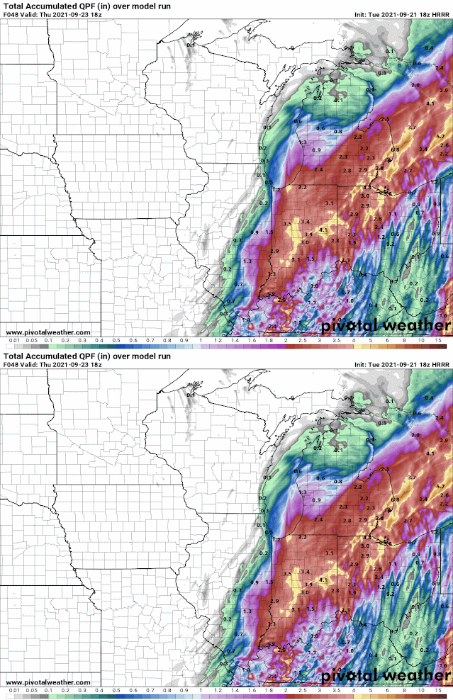
Latest version of the GFS and various other models bring copious amounts of rain in this weeks transition. Maybe somewhat overdone on extent of heaviest rainfalls but there is unusual strong agreement in a notable wet period later tointo Thursday night as the colder air oozes into the area. Look for temperatures to notch down with time into the 40s for lows and 50s to around 50 by the weekend. Along and mainly behind a cold front; a low pressure deepens over the eastern Great Lakes into Thursday. Looking at the moisture available and lift along with stalling of the system, generally 1.50" - 3.50" of rain and to upwards of 4+" in pockets of rain is possible into Thursday eve. Positioning of heaviest rain seems to be at this time over the south-central or east portions of Southern Michigan. We'll see how the system unfolds with time.
Also; note the two aggressive upper air "bowling-ball" colder vorticity (or spin in the atmosphere) systems that at this time are slated to affect the Great Lakes into the weekend. One takes form right over the Lakes (and contains much of the heavy rain) and the second; shoots southeast into the Great Lakes from southwest Canada. This is reminiscent of Clipper systems seen in the fall and especially winter. Hmm...shades of the winter pattern developing? Well; another La Nina is on the horizon for the autumn into the winter and Clippers were active last winter and of course; Clippers are dominant in most La Ninas.
Upper air pattern into the weekend
Surface systems
GFS QPF thru late Thu
3 KM NAM QPF thru late Thu
EURO QPF thru late Thu
Latest HRRR Short Term QPF thru Thu afternoon /as of 18z/
Stay tune for brief updates on FB under:
William Deedler/Southeast Michigan Weather Historian
In addition: we'll start looking at what the winter weather is expected to look like by first discussing hemispheric patterns evolving.
________________________________________________
UPDATE_SEP 24TH 2021
Well! - Total 36 hours rainfall from 5pm Wed to 5am Fri
Making weather fun while we all learn,
Bill Deedler -SEMI_WeatherHistorian


