5/31/14

Will The Summer of 2014 Be a Cool One?


Summer 2014 Outlook for Southeast Lower Michigan


Temperatures :

Overall; a comfortable summer is on tap as I look for temperatures to average around normal to slightly below for the summer. That being said I don't anticipate a notably cool summer. I look for temperatures to average between +1.0 degree and -2.0 degrees of the summer norms across Southeast Lower Michigan (see a more thorough discussion under Analogues).


Rainfall:

I look for rainfall to be quite variable as mixed data presents conflicting results but this is not unlike many summers. Taking all data (past and present) into account; rainfall is expected to be around normal over the southern sections of Southeast Lower Michigan and normal to below across the Saginaw Valley and Thumb Region. Rainfall trend data intimates the wetter weather in the early to mid summer with drier conditions later summer (see a more thorough discussion under Analogues).


Discussion:

Many are calling for a cooler than normal summer across the Great Lakes; including Southeast Lower Michigan. A common reasoning is the colder than normal Great Lakes water temperatures left over by the horrendously long, cold and stormy winter. As of this writing, ice still remains in scattered sections of Lake Superior on Memorial Weekend. 

                                                                    (Photo courtesy: Melissa Ellis)

The colder than average lake water temperatures surely affect the shore and inland areas near the Great Lakes in the spring, especially when the wind's onshore. The more pertinent questions are; will there be enough of an affect to last into the summer and state-wide temperatures? After all, we do see the opposite effect every fall into at least, early winter across the Great Lakes as their mammoth water heat reservoirs temper the chilly Arctic blasts. So then; will the Lakes temper a bit, summer's heat blasts across the entire region; courtesy of mom nature's air conditioning? While this may occur early in the summer season state-wide and especially near shore areas; history and analogue data suggests a mixed picture otherwise for the balance of the summer. And besides; here in Southeast Lower Michigan warm to hot winds from the south-southwest do not pass over any large Great Lake anyway.

Frigid Water Temperatures of Lake's Huron and Michigan at the close of May


To investigate this assumption further, in addition to the usual analogue data I post for the season; I also included another chart of analogues so to speak, the cold winters and subsequent following summers. Simply put; If a terribly cold winter chilled down the Great Lakes enough to start off the summer season with below normal water temperatures, then what happened in Southeast Lower Michigan that summer?  This is especially true in those summers where the springs were also on the cool-side, as in this year. And the best way to check that out would be to take the top 20 coldest winters and see what kind of summer followed but again; just in Southeast Lower Michigan. By doing this; obviously if Southeast Lower Michigan had one cold, bitter winter, then there's a strong likelihood so did the state...and the Great Lakes. Subsequently; the best correlation to this year would be where temperatures in the spring averaged below normal.

Because more recent normals for Detroit have been "contaminated" by urban sprawl and its heat island, I used a 100 year normal before the pronounced heat island evolved at Detroit Metro Arpt in the mid 1980s. Since most of the colder winters were also during that time; it's a better representation of a true normal for the summers...a hundred year average. As one can see; the old-time 100 year normal is well over a degree cooler than the latest (70.6 as compared with the latest 30 year normal of 71.9).

Cold Winter, Cool Summer Analogue Study 


 Looking at the chart above at the 21 coldest winters and the 20 summers that followed (2014 is yet to be determined); we find a subtle but definite correlation between cold winters and cool summers. There is even a better correlation between a cold winter and cool spring followed by a cool summer. Out of the original 20 coldest winters; eight of the following summers were more than a degree below normal using our legend. Of the remaining twelve summers; nine summers were normal and three were warmer. Therefore; 40% of the summers the temperatures averaged below normal; 45% were normal while just 15% of the summers were above normal. Therefore; relating just this analogue study to this summer; the chances of a normal to below normal summer are an impressive 85%.

Finally; narrowing down this data further by just using the seven cooler springs that followed the cold winter (and again, paralleling the past six months); four were followed by a cool summer and three were followed by a normal summer. None of these cold winter - cool spring periods were followed by a hot summer, or even an above normal /1.0+/ summer. In percentage terms on this data alone then; 57% of the summers were cool and 43% were normal.

Now, on to the typical season analogue study...

What do the Summer Analogues Project?


Remarkably; the typical season analogues chosen for parallel timing of hemispheric climate conditions at the present reflect our previous cold summer, cool summer analogues to a large extent. There is just a slight difference; normal summers have a slight edge over cool summers which is the reverse of the cold winter, cool summer analogues, where cool summers had the edge. The general message is the same however, where a cool to normal summer is preferred by all analogue data presented. In these carefully chosen analogue years; a prolonged period of neutral ENSO's were followed by an ever increasing summer El Nino. The two warm summers of the lot in this analogue study were the more recent summers of 1991 and 2002 with average temperatures of 73.6 and 73.4, respectively. Neither of these warm summers appeared in the previous cold winter, cool summer analogue study .

What are the best performing analogues thus far suggesting for the summer temperatures?

Temperatures

Since late fall of 2013, we have had a couple of years which take full marks for past prediction of the past few seasons; 1880-81 and 1981-82. And, maybe not surprising; 1881 contained a normal summer while 1982 had a cool summer (like our two prevalent trends seen). Another year; 1899 joins these analogue ranks as a decent performer during the winter and a good parallel this spring. All three analogues projected a cool spring with the temperature pattern we've seen this spring with time; below normal - normal - above normal. These analogue springs averaged below normal because of a very cold beginning to the season but will a gradual trend change from below to normal to above (Mar; Apr, May). The Summer of 1899 turned out to have a normal summer, therefore we have two normal summers and one below for the recent better performing analogues. The over all summers were cool to normal with June having the best chance being the coolest month relative to normal with August a close second. July's were the notably warm months  relative to normal.

Rainfall

Rainfall projections for the summer, are really a mixed bag, as it frequently is in the summer with four normal rainfalls, four below and two above with the average skewed on the drier side. A notable trend from many of the summer analogues are wetter conditions early and/or mid summer with drier weather later summer. If high pressure over central Canada and the upper low over eastern Canada exude more force, then a summer on the drier side is likely. This will have to be watched as to where these systems dominate and rainfall patterns evolve.

That being said; it is reasonable when considering all the data and recent trends this spring to keep the prevailing dry/wet oscillations in view. While I look for generally normal rains this summer especially southern regions, I also look for the decidedly typical dry-spell this summer which frequently happens (I researched and wrote about this in 1997 and updated in 2007, while with the NWS). Below are the temperature and precipitation composites for the analogue years in the research. One the left is the data against the 105 year normal; while on the right is the same data against the latest 30 year normal /1981-2010/. In Southeast Lower Michigan; average summer temperatures prevailed against the 105 year normal and normal to below against the 30 year. The rainfall averaged close to normal against the 105 year norm and below against the 30 year.


Analogue Upper Wind Data

Past analogue upper wind data paints upper height ridging and oscillations extending from the Rocky Mountains eastward into the Gulf States and points north into the Great Plains to Eastern Great Lakes. In conjunction; an Upper low pressure oscillated over the eastern half of Canada and extended south and oscillated from the western Great Lakes to off the East Coast. This type of pattern would give us overall normal temperatures during the summer with warm to hot spells routinely extinguished by parading Canadian cool air masses. If one or the other prevails more; of course it will be cooler or warmer than expected. Looking at recent past trends along with this analogue data and subsequent pattern suggests to me normal to below normal temperatures.


The composite upper air anomaly data below shows more clearly what we are up against this summer as far as opposing upper air features. The composite shows where upper air systems were more exaggerated than during a normal summer; thus an anomaly. A blocking upper high pressure system was noted during these summers from central Canada, south into the mid Mississippi Valley. It is the same system I mentioned above that oscillates back and forth but was more dominant up in central Canada in these analogue summers. This system will be responsible for bringing the warm winds from the south when over and east of us and cooler winds from the north when west of the Lakes (blue arrows). Meanwhile; the cold upper low that was so dominant for months /Polar Vortex/ shares the stage with the high pressure as it aligns from eastern Canada south into the eastern U.S. It will be responsible for pushing cooler air southeast or south (in the form of back-door cold fronts) into the Lakes Region (also blue arrows), as it has for months; albeit weaker. Were the upper wind features develop as in the past; sunshine during the summer would average normal to above with the placement of the high.

Another interesting feature is the pronounced upper low feature that showed up over central and southern California; this too will aid in pushing warmer air northeast (red arrows) into the Plains, Mississippi Valley and Midwest behind the upper high pressure. As one can easily see, the zone of air mass confrontation between all of these systems is like most summers and extends from the Great Plains, east through the Great Lakes and on to the East Coast. If the upper high pressure and low pressure heights in Canada play out more to our east, then storms will be more focused to the south and east.


Stormy Weather?

As mentioned above; the data to me depicts a notable confrontation zone and I believe we have just recently entered it as of late May. Typically, the busiest times for severe weather in these parts is June into July; with mid June to mid July prime-pickens. I've included the severe weather stats for Southeast Lower Michigan since 1980. Looking above at our analogue summers since then are 1982, 1991, 1997 and 2002 and all but 1982 contained normal to above normal (or busy) severe seasons. That's not surprising given the jet stream that's been dominant in Canada this year. Were this upper jet continued to be aggressive, notable wind events, squall lines and possibly a derecho event or two across the country would be the risk. Off the top of my head; both 1991 (derecho) and 1997 (squall line and tornado) contained notable July squall lines and tornado and 2002's severe weather season was overall, busy.


Annual Totals
Year
Hail
Wind
Tornado
Total

Rpt
Days
Rpt
Days
Rpt
Days
Rpt
Days
1980
58
17
186
32
29
16
116
37
1981
13
7
54
21
5
3
23
22
1982
45
15
117
19
17
9
79
28
1983
86
15
283
30
22
12
130
34
1984
31
12
79
29
20
12
71
39
1985
103
16
158
22
13
9
129
31
1986
72
21
165
36
34
19
140
46
1987
30
16
196
31
16
13
62
38
1988
75
22
198
35
19
10
113
40
1989
32
17
128
30
19
13
70
38
1990
33
16
141
21
23
12
79
27
1991
78
24
320
39
29
10
136
46
1992
66
24
262
32
52
16
170
42
1993
61
22
168
29
8
7
77
37
1994
159
30
239
37
12
8
183
48
1995
76
27
272
41
8
5
92
48
1996
120
35
244
41
14
8
148
56
1997
118
30
330
39
21
5
160
45
1998
270
36
595
39
28
16
326
52
1999
165
28
385
40
15
9
195
45
2000
292
30
381
46
16
9
324
53
2001
198
39
356
53
41
11
280
66
2002
145
39
394
53
22
6
189
62
2003
359
42
559
47
17
12
393
55
2004
326
45
489
45
22
10
370
60
2005
164
32
523
38
3
3
170
48
2006
424
50
404
49
12
9
448
70
AVG
133
26
282
36
20
10
436
45


Hemispheric Data


As mentioned above; Summer will be accompanied by a progressively ensuing El Nino but I just included this small amount of data below as I expect it will have negligible affects on our weather at home this summer. It will be the fall and especially wintertime that this little baby boy will be more of a player. Check out the CFSv2 models projection into the winter; quite interesting...


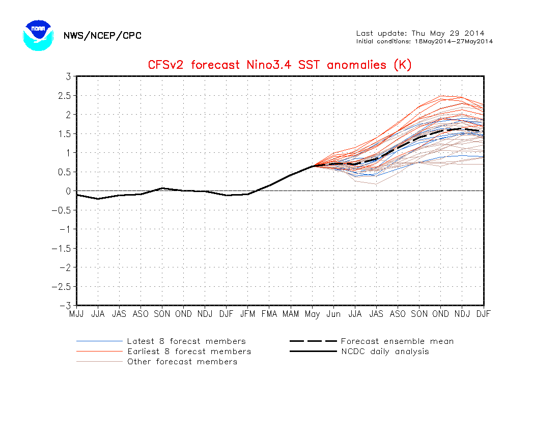
And while on the subject of the CFS, lets take a look at its projection for the summer. Really nothing earth-shaking here, though she does intimate the cooling Lakes effect and possibly stalled fronts in the lower Lakes on the rainfall side. I think we are seeing that starting now as of late May.

Temperatures


Rainfall

Interesting how the CVS summer precipitation pattern projection above "mimics" that of the Summer of 1982 (one our best analogues) below. The overall trend is there but the drier areas in the north are displaced further north into Canada in the computer projection closer and just downwind to the upper high pressure block - logical. The heavier precipitation is more to the west in the computer projection (closer to the upper low pressure out west) while the dry Texas and wet Florida are nearly a duplicate. In our region, the wetter areas are over and just to the south of Michigan in the model while in 1982 they were over west-central Michigan into the western Lakes.


Try to get out and enjoy the Summer but if swimming in the Great Lakes; just wait a bit longer for those lake temperatures to warm up! Brrrrr.


Making weather fun while we all learn,
Bill Deedler -SEMI_WeatherHistorian


5/10/14

Update 5/16/14; Temperatures Flirting Near Record Cold Into the Weekend

Update 5/16

Well below normal temperatures are firmly entrenched over Southeast Lower Michigan, some overnight lows were as much as 20 degrees below normal. Unfortunately; I don't have any better news into the weekend with temperatures still expected to fall into the lower 30s to lower 40s Saturday and possibly now, even Sunday. Scattered frost is also likely in open areas and away from the lakes and major cities. See the records I posted below under 5/14 update below as a reference. While I still feel most records will stay intact, there is the risk of falling in or near record territory at some locations over the weekend.

Take a look at the cold overnight lows Friday morning....

000
ASUS63 KDTX 161521
RTPDTX
MORNING TEMPERATURE AND PRECIPITATION SUMMARY
NATIONAL WEATHER SERVICE DETROIT/PONTIAC MI
1121 AM EDT FRI MAY 16 2014

VALUES REPRESENT YESTERDAY`S HIGHS....LOW OVER THE LAST 12 HOURS
AND PRECIPITATION OVER THE LAST 24 HOURS ENDING AT 8 AM EDT


.BR DTX  0516  ES DH00/TAIRZX/DH07/TAIRZP/TA/PPDRZZ


:SOUTHEAST MICHIGAN -- TEMPERATURE AND PRECIPITATION STATIONS
:.......................................................
:       STATION              MAX / MIN  / 8 AM  / 24-HR
:        NAME                TEMP/ TEMP / TEMP  / PRECIP
:.......................................................
WHKM4: NWS WHITE LAKE      :   54 /  31  /  36  / 0.37
123M4: ANN ARBOR           :   57 /  35  /  35  / 0.36
ADG  : ADRIAN AIRPORT      :   60 /  35  /  38  / 0.19
BAX  :*BAD AXE AIRPORT     :   48 /  37  /  40  /
CFS  :*CARO AIRPORT-TUSCOLA:   50 /  38  /  40  /
DET  : DETROIT CITY AIRPORT:   67 /  38  /  41  / 0.43
DTW  : DETROIT METRO ARPT  :   64 /  36  /  38  / 0.13
FNT  : FLINT BISHOP AIRPORT:   52 /  36  /  39  / 0.21
ONZ  :*GROSSE ILE AIRPORT  :   63 /  37  /  39  /
OZW  :*HOWELL AIRPORT      :   49 /  33  /  37  /
DUH  :*LAMBERTVILLE AIRPORT:   63 /  36  /  41  /
D95  :*LAPEER DUPONT AIRPRT:   51 /  35  /  37  /
IKW  :*MIDLAND AIRPORT     :   48 /  38  /  40  /
TTF  :*MONROE AIRPORT      :   63 /  36  /  39  /
RNP  :*OWOSSO AIRPORT      :    M /   M  /   M  /
PTK  : PONTIAC AIRPORT     :   56 /  34  /  37  / 0.34
P58  : PORT HOPE           :   49 /  37  /  38  / 0.33
PHN  :*PORT HURON AIRPORT  :   64 /  36  /  39  /
MBS  : SAGINAW - TRI-CITIES:   49 /  37  /  39  / 0.28
HYX  :*SAGINAW-HARRY BROWNE:   50 /  36  /  37  /
VLL  :*OAKLAND/TROY AIRPORT:   62 /  37  /  38  /
YIP  : YPSILANTI WILLOW RUN:   66 /  37  /  40  / 0.24
.END


*THE TEMPERATURE DATA FOR THESE SITES ABOVE REPRESENT THE HIGHEST AND
 LOWEST TEMPERATURES THAT WERE REPORTED ON THE METAR OBSERVATIONS
 THAT TRANSMIT THREE TIMES AN HOUR AND MAY NOT REPRESENT THE ACTUAL
 HIGH OR LOW FOR THAT SITE. THESE SITES DO NOT MEASURE
 PRECIPITATION.
.....................................................................


THE FOLLOWING COOPERATIVE OBSERVER SITES REPORT FROM MIDNIGHT TO
MIDNIGHT THE PREVIOUS DAY.


.BR DTX  0516  ES DH07/TAIRZX/TAIRZN/TA/PPDRZZ


:SOUTHEAST MICHIGAN -- TEMPERATURE AND PRECIPITATION STATIONS
:.......................................................
:       STATION               MAX / MIN  / 12 AM /24-HR
:        NAME                 TEMP/ TEMP / TEMP  /PRECIP
:.......................................................
ARNM4: ADRIAN              :   59 /  41  /  42  / 0.54
MILM4: MILFORD - GM GROUNDS:   54 /  41  /  41  / 0.63
MDLM4: MIDLAND             :   58 /  37  /  37  / 1.39
MTCM4: MT CLEMENS SELFRIDGE:   65 /  45  /  45  / 0.88
PRHM4: PORT HURON          :   64 /  43  /  46  / 0.94
SGNM4: SAGINAW 5W          :   48 /  37  /  37  / 1.58
.....................................................................


COOPERATIVE OBSERVATIONS VALUES ARE FOR APPROXIMATELY THE PREVIOUS 24
HOURS FROM YESTERDAYS OBSERVATION TIME TO TODAY`S OBSERVATION TIME.


.BR DTX  0516  ES DH07/TAIRZX/TAIRZN/TA/PPDRZZ


:SOUTHEAST MICHIGAN -- TEMPERATURE AND PRECIPITATION STATIONS
:.........................................................
:       STATION            OB   /MAX / MIN  / OB   /24-HR
:        NAME              TIME /TEMP/ TEMP / TEMP /PRECIP
:.........................................................
: ***MIDLAND COUNTY***


: ***BAY COUNTY***


: ***HURON COUNTY***
BDAM4:  BAD AXE           :0725/   48 /  37  /  38  / 0.33
FLNM4:  FILION 5NNW       :M   /    M /   M  /   M  / 0.26
POAM4:  PORT AUSTIN       :0747/   48 /  36  /  37  / 0.30
PHPM4:  PORT HOPE         :0800/   50 /  36  /  38  / 0.40


: ***SAGINAW COUNTY***
CHSM4:  CHESANING         :0730/      /      /      / 0.43
FKMM4:  FRANKENMUTH 1SE   :0740/   49 /  35  /  36  / 0.20
MERM4:  MERRIL 2E         :0800/   49 /  35  /  38  /    M
SAGM4:  SAGINAW           :0800/   48 /  35  /  37  / 0.38


: ***TUSCOLA COUNTY***
CARM4:  CARO              :0710/   56 /  35  /  36  / 0.25
VSSM4:  VASSAR            :0700/   50 /  36  /  37  / 0.34


: ***SANILAC COUNTY***
LEXM4:  LEXINGTON         :0725/   55 /  36  /  39  / 0.60
SANM4:  SANDUSKY          :0639/   53 /  36  /  37  / 0.40


: ***SHIAWASSEE COUNTY***
CORM4:  CORUNNA 2NE       :0600/   54 /  36  /  36  / 0.79
DRNM4:  DURAND            :0800/   49 /  34  /  37  / 0.21


: ***GENESEE COUNTY***
BUNM4:  BURTON 4N         :0700/   54 /  33  /  37  / 0.30
FLTM4:  FLINT  7W         :0800/   51 /  35  /  38  / 0.22
LIDM4:  LINDEN            :0720/   49 /  34  /  37  /    M
GODM4:  GOODRICH          :0730/   51 /  33  /  37  / 0.16


: ***LAPEER COUNTY***
LPEM4:  LAPEER 2W         :0900/   52 /  34  /  38  / 0.04
LPRM4:  LAPEER            :0730/   52 /  35  /  37  / 0.30


: ***ST. CLAIR COUNTY***
YALM4:  YALE              :0630/   59 /  35  /  37  / 0.47


: ***LIVINGSTON COUNTY***
HOWM4:  HOWELL            :0800/   52 /  34  /  39  / 0.31
WHLM4:WHITMORE LK 1N      :0700/   54 /  35  /  35  / 0.40


: ***OAKLAND COUNTY***
FARM4:  FARMINGTON        :0730/   59 /  34  /  36  / 0.25
PONM4:  PONTIAC           :1052/   57 /  35  /  43  / 0.02
WSBM4:  WEST BLOOMFIELD   :0615/      /       /     / 0.30


: ***MACOMB COUNTY***
RICM4:  RICHMOND 4NNW     :0800/   62 /  36  /  39  / 0.62


: ***WASHTENAW COUNTY***
AASM4: ANN ARBOR-SOUTHEAST:0730/   59 /  35  /  37  / 0.28
CHLM4:  CHELSEA           :0943/   52 /  34  /  42  / 0.02
MCHM4:  MANCHESTER        :0705/   56 /  33  /  34  / 0.36
SLNM4:  SALINE 4SW        :0900/   57 /  26  /  37  / 0.09
SALM4:  SALINE            :0815/   60 /  35  /  41  / 0.24


: ***WAYNE COUNTY***
DBNM4:  DEARBORN          :0600/   64 /  37  /  37  / 0.20
DRBM4:U OF M DEARBORN     :0900/   63 /  34  /  41  / 0.04
GPFM4:  GROSSE PTE FARMS  :0800/   64 /  36  /  39  / 0.59
WYTM4:  WYANDOTTE         :0800/      /       /     / 0.15


: ***LENAWEE COUNTY***
BLIM4:  BLISSFIELD        :0630/      /       /     / 0.18
MRIM4:  MORENCI           :0730/   60 /  32  /  35  / 0.27
TECM4:  TECUMSEH          :0630/   60 /  33  /  35  / 0.42
TIPM4:  TIPTON 2WNW       :0800/   58 /  33  /  38  / 0.26


: ***MONROE COUNTY***
DNDM4:  DUNDEE            :0700/   62 /  35  /  36  / 0.22
MLIM4:  MILAN             :0605/   62 /  35  /  35  / 0.26
MNRM4:  MONROE            :0900/   62 /  35  /  43  / 0.08
NWPM4:  NEWPORT 4SSE      :0700/   61 /  37  /  37  / 0.19
.END

 
Update 5/14

First things first; stormy weather over the past few days brought scattered damaging thunderstorm winds and flooding rains across Southeast Lower Michigan. Here is the Severe Weather Report for Tuesday, 5/13 from the NWS in White Lake /DTX/. None of the three "tornadoes" reported during Monday's (5/12) storms were ever confirmed.

Below this summary, is the rest of the week's outlook.

Severe Thunderstorm Summary for May 13, 2014

Severe thunderstorms developed ahead of a cold front on the afternoon of May 13, 2013. Storms raced east across most of Southeast Lower Michigan, causing a broad area of damage. Several trees and power lines were downed, along with reports of wind gust measurements ranging from 50 to 60 mph.


PRELIMINARY LOCAL STORM REPORT...SUMMARY
NATIONAL WEATHER SERVICE DETROIT/PONTIAC MI
610 PM EDT TUE MAY 13 2014

..TIME...   ...EVENT...      ...CITY LOCATION...     ...LAT.LON...
..DATE...   ....MAG....      ..COUNTY LOCATION..ST.. ...SOURCE....
            ..REMARKS..

0232 PM     TSTM WND DMG     3 NW BRIGHTON           42.56N 83.83W
05/13/2014                   LIVINGSTON         MI   AMATEUR RADIO 

            THE TOP OF A 6 INCH DIAMETER TREE WAS BLOWN OFF.

0252 PM     TSTM WND DMG     3 ESE PINCKNEY          42.44N 83.90W
05/13/2014                   LIVINGSTON         MI   TRAINED SPOTTER

            TREES AND LARGE LIMBS DOWN

0254 PM     TSTM WND DMG     2 WNW ANN ARBOR         42.28N 83.77W
05/13/2014                   WASHTENAW          MI   LAW ENFORCEMENT

            HURON - DEXTER AND MAPLE STREETS...6 HOMES WITH
            STRUCTURAL DAMAGE.

0255 PM     TSTM WND DMG     4 SSW ANN ARBOR         42.23N 83.76W
05/13/2014                   WASHTENAW          MI   TRAINED SPOTTER

            3 INCH TREE LIMBS DOWNS ELLSWORTH AND LOHR

0258 PM     TSTM WND DMG     1 WSW ANN ARBOR         42.27N 83.75W
05/13/2014                   WASHTENAW          MI   PUBLIC        

            LARGE TREE UPROOTED AND FELL ON TOP OF DETATTACHED GARAGE
            AT MAIN AND KOCH ROADS

0302 PM     TSTM WND DMG     5 N YPSILANTI           42.32N 83.63W
05/13/2014                   WASHTENAW          MI   EMERGENCY MNGR

            NUMEROUS LARGE TREES DOWN ON WIRES.

0302 PM     TSTM WND DMG     UBLY                    43.71N 82.93W
05/13/2014                   HURON              MI   911 CALL CENTER

            DOWNED POWER LINES

0311 PM     FLOOD            FLINT                   43.02N 83.69W
05/13/2014                   GENESEE            MI   TRAINED SPOTTER

            MULTIPLE STREETS FLOODED- VEHICLES STRANDED NEAR ATHERTON
            AND HEMPHILL ROADS WEST OF SAGINAW STREET.

0311 PM     TSTM WND GST     4 ESE ANN ARBOR         42.26N 83.66W
05/13/2014  E65.00 MPH       WASHTENAW          MI   TRAINED SPOTTER

            NO REPORT OF DAMAGE AT THIS TIME.

0314 PM     TSTM WND GST     OXFORD                  42.82N 83.25W
05/13/2014  E60.00 MPH       OAKLAND            MI   TRAINED SPOTTER

            FENCE BLOWN OVER

0316 PM     TSTM WND GST     ROMULUS                 42.22N 83.37W
05/13/2014  M58.00 MPH       WAYNE              MI   ASOS          

0318 PM     TSTM WND DMG     FARMINGTON HILLS        42.49N 83.38W
05/13/2014                   OAKLAND            MI   BROADCAST MEDIA

            LARGE TREE DOWN. TIME ESTIMATED OFF RADAR.

0330 PM     TSTM WND DMG     3 S PETERSBURG          41.85N 83.71W
05/13/2014                   MONROE             MI   911 CALL CENTER

            POWER LINES DOWN

0332 PM     TSTM WND DMG     5 S DUNDEE              41.88N 83.67W
05/13/2014                   MONROE             MI   911 CALL CENTER

            LARGE TREE AND WIRES DOWN.

0336 PM     TSTM WND DMG     2 SSW IDA               41.88N 83.59W
05/13/2014                   MONROE             MI   911 CALL CENTER

            LARGE TREE AND POWER LINES DOWN

0337 PM     TSTM WND GST     CLINTON TOWNSHIP        42.59N 82.92W
05/13/2014  M61.00 MPH       MACOMB             MI   PUBLIC        

            VIA FACEBOOK

0338 PM     TSTM WND GST     1 ESE WARREN            42.49N 83.01W
05/13/2014  E60.00 MPH       MACOMB             MI   TRAINED SPOTTER

            JUST NORTH OF 11 MILE RD ON HOOVER IN WARREN.

0338 PM     TSTM WND DMG     5 W MACOMB TOWNSHIP     42.67N 83.01W
05/13/2014                   MACOMB             MI   PUBLIC        

            TWO LARGE TREES DOWN AT 23 MILE AND SHELBY. REPORT VIA
            FACEBOOK.

0338 PM     TSTM WND DMG     MELVIN                  43.18N 82.86W
05/13/2014                   SANILAC            MI   911 CALL CENTER

            POWER POLE AND WIRES DOWN. TIME ESTIMATED FROM RADAR.

0355 PM     MARINE TSTM WIND MOUNT CLEMENS           42.60N 82.88W
05/13/2014  M39.00 MPH       MACOMB             MI   ASOS          

0400 PM     TSTM WND DMG     COLUMBUS                42.89N 82.67W
05/13/2014                   ST. CLAIR          MI   BROADCAST MEDIA

            LARGE TREE DOWN ON TRUCK.

0415 PM     TSTM WND DMG     5 ENE RICHMOND          42.83N 82.67W
05/13/2014                   ST. CLAIR          MI   911 CALL CENTER

            TREES DOWN/POWER OUT GRATIOT AND ELLSWORTH.

0417 PM     MARINE TSTM WIND PORT HURON              42.99N 82.43W
05/13/2014  M40.00 MPH       ST. CLAIR          MI   TRAINED SPOTTER

0421 PM     TSTM WND DMG     SSE ST. CLAIR           42.82N 82.49W
05/13/2014                   ST. CLAIR          MI   911 CALL CENTER

            MULTIPLE REPORTS OF TREES AND POWER LINES DOWN

0440 PM     FLOOD            6 NNW GROSSE POINTE     42.47N 82.94W
05/13/2014                   MACOMB             MI   TRAINED SPOTTER

            WATER OVER ROADS BETWEEN GRATOIT AND KELLY STREETS.

0453 PM     TSTM WND DMG     4 E RICHMOND            42.81N 82.68W
05/13/2014                   ST. CLAIR          MI   911 CALL CENTER

            TREES DOWN/POWER OUT. BARTEL RD.

0453 PM     TSTM WND DMG     SSE ST. CLAIR           42.82N 82.49W
05/13/2014                   ST. CLAIR          MI   911 CALL CENTER

            TREES DOWN/POWER OUT HATHAWAY/OAKLAND RD.
___________________________________________________________________
Rest of the week's Outlook...

Update 5/14/14; First More Rain Then the Cold as Previously Noted

Low pressure system along the cold front that pushed the cold front and severe weather through here Tuesday; has moved northeast well into Canada. However with a strong nearly parallel jet aloft along with upper level energy and copious amount of moisture, look for rain and a few embedded thunderstorms to make an appearance overnight into Thursday. Rainfall amounts of  around .50" to 1.50" will be widespread with locally higher amounts.

After our mid week rain; the much cooler air mentioned days ago in this current blog will mover into the area Thursday night through the weekend. While temperatures will drop into the mid 30s to lower 40s on the coldest early mornings (most likely Friday and Saturday morning); the highest risk of frost will be in open areas where the ground has dried out some. With the strong warm up recently and heavy rains; those factors will tend to negate frost development due to surface and below ground temperature moderation. In addition as always, cloud cover and wind will also help dictate outcome.

Still one can not rule it (patchy frost) out as the air coming across the region is notably cold for mid May. Perusing records for mid May is a help at determining what have been the worst cold snaps so late in spring. As you can see record cold lows around 30 degrees have been the lowest, while very cool afternoon highs have been in the mid to upper 40s for record low max's. I feel most of these will remain intact.

Detroit Rec       Hi's     Low Max's        Rec Low's
16 70 49 60.0 92/1962 47/1945 70/1962 32/1984 81/1962 44/1957 1.09/1945 16
17 70 50 60.0 93/1962 48/1916 67/1962 31/1973 80/1962 43/1973 1.22/1980 17
18 71 50 60.0 93/1962 48/1915 70/1962 32/1973

Flint Rec           Hi's     Low Max's         Rec Low's
16 69 45 57.0 90/1962 46/1945 65/1962 30/1921 78/1962 41/1956 2.16/1974 16
17 69 46 57.0 89/1962 47/2002 62/1999 29/1973 75/1999 41/2002 1.85/1923 17
18 69 46 58.0 90/1998 48/2002 64/1962 29/1973

Saginaw Rec    Hi's     Low Max's         Rec Low's
16 68 47 57.0 90/1962 46/1923 67/1962 32/1952 79/1962 42/1983 1.40/1923 16
17 68 47 58.0 89/1936 45/1916 63/1977 32/1983 75/1977 41/2002 1.98/1986 17
18 69 47 58.0 92/1998 49/1969 64/1971 31/1925

_______________________________________________________________


Update...5/11/14

Sunday afternoon's Severe Weather Update for Monday


May 11, 2014 1730 UTC Day 2 Convective Outlook
Updated: Sun May 11 17:30:53 UTC 2014 (Print Version | 20140511 1730Z Day 2 shapefile | 20140511 1730Z Day 2 KML)
Probabilistic to Categorical Outlook Conversion Table
Categorical Probabilistic
 Population  Cities  CWAs  Interstates  Counties  ARTCC  FEMA Regions
 
Categorical Day2 1730Z Outlook
Risk Area (sq. mi.) Area Pop. Some Larger Population Centers in Risk Area
SLIGHT 228,089 32,443,953 Chicago, IL...San Antonio, TX...Austin, TX...Milwaukee, WI...Kansas City, MO...
 Forecast Discussion
   SPC AC 111729

   DAY 2 CONVECTIVE OUTLOOK  
   NWS STORM PREDICTION CENTER NORMAN OK
   1229 PM CDT SUN MAY 11 2014

   VALID 121200Z - 131200Z

   ...THERE IS A SLGT RISK OF SVR TSTMS ACROSS PARTS OF THE LOWER MO
   VALLEY...MID TO UPPER MS VALLEY AND SRN GREAT LAKES REGION...

   ...THERE IS A SLGT RISK OF SVR TSTMS ACROSS PARTS OF SW AND CNTRL
   TX...

   ...SUMMARY...
   CLUSTERS OF SEVERE STORMS ARE POSSIBLE FROM THE SOUTHERN GREAT LAKES
   SOUTHWESTWARD INTO THE MID TO UPPER MISSISSIPPI VALLEY MONDAY
   AFTERNOON AND EVENING.  SEVERE THUNDERSTORMS WILL ALSO BE POSSIBLE
   IN THE SOUTHERN GREAT PLAINS MONDAY AFTERNOON AND EVENING. DAMAGING
   WINDS AND LARGE HAIL SHOULD BE THE PRIMARY HAZARDS ALTHOUGH AN
   ISOLATED TORNADO THREAT CAN NOT BE RULED OUT.

   ...MID TO UPPER MS VALLEY/GREAT LAKES...
   AN UPPER-LEVEL TROUGH WILL MOVE INTO THE CNTRL AND NRN PLAINS ON
   MONDAY AS A COLD FRONT ADVANCES SEWD ACROSS THE MID MO VALLEY AND
   CNTRL PLAINS. AT THE START OF THE PERIOD...SCATTERED THUNDERSTORMS
   APPEAR LIKELY TO BE ONGOING NEAR THE EXIT REGION OF THE LOW-LEVEL
   JET IN PARTS OF THE UPPER MS VALLEY AND MID MO VALLEY. THIS ACTIVITY
   SHOULD MOVE EWD DURING THE DAY AS MODERATE INSTABILITY DEVELOPS
   AHEAD OF THE FRONT FROM IA SWD ACROSS MO. THUNDERSTORMS SHOULD
   INITIATE ALONG THIS CORRIDOR DURING THE AFTERNOON ALONG AND JUST
   AHEAD OF THE BOUNDARY. OTHER STORMS MAY INITIATE ACROSS THE WARM
   SECTOR NEWD ACROSS LOWER OH VALLEY INTO THE GREAT LAKES REGION.

   NAM FORECAST SOUNDINGS AT 00Z/TUE FROM CHICAGO IL SWWD INTO CNTRL MO
   SHOW MLCAPE AROUND 1200 J/KG WITH 30 TO 35 KT OF 0-6 KM SHEAR. THIS
   SHOULD BE ENOUGH FOR STORM ORGANIZATION AS CELLS INCREASE IN
   COVERAGE LATE MONDAY AFTERNOON. STEEP LOW-LEVEL LAPSE RATES AND
   UNIDIRECTIONAL WIND PROFILES SHOULD BE FAVORABLE FOR STRONG WIND
   GUSTS WITH SHORT-LINE SEGMENTS AND MULTICELL CLUSTERS. ISOLATED
   LARGE HAIL MAY ALSO OCCUR IN AREAS THAT DESTABILIZE THE MOST.

   FURTHER TO THE NORTHEAST...MODEL FORECASTS DEVELOP A POCKET OF
   ENHANCED INSTABILITY ACROSS LOWER MI BENEATH AN EWD MOVING
   UPPER-LEVEL RIDGE. IN RESPONSE...THUNDERSTORMS MAY INITIATE ON THE
   NRN END OF THE STRONGER INSTABILITY AS LOW-LEVEL CONVERGENCE BECOMES
   ENHANCED MONDAY AFTERNOON. FORECAST SOUNDINGS AT DETROIT AT 21Z/MON
   SHOW MLCAPE AROUND 1200 J/KG WITH 35 KT OF 0-6 KM SHEAR. IN
   ADDITION...LOW-LEVEL LAPSE RATES ARE STEEP AND THERE IS SOME
   DIRECTIONAL SHEAR BELOW 850 MB. THIS SHOULD BE ENOUGH FOR AN
   ISOLATED SEVERE THREAT WITH WIND DAMAGE AND HAIL POSSIBLE.

Mid Week Notes Update:
NAM/Euro agree on bringing second low Pressure storm mid week on tail end of polar front; see if GFS comes arnd to this scenario with time. It would be very WET & psbly stormy again if that happened...depends how far north she pushes back up.


5/10/14__________________________________________________________
Model Guidance for the past few days has been coming together for the definite risk of severe weather early in the week; then a return to below to well below normal temperatures with another shot of polar air later in the week.

A developing low pressure system will surge warm, humid air back into the region on Monday and then; push a cold front through Southeast Lower Michigan later Tuesday.  Severe weather will likely form along and behind the warm front as the air becomes very unstable, especially if intensified by surface heating during the day. Another round of severe weather is possible Tuesday along and ahead of the cold front.

Latest trajectories of both the NAM and GFS models reflect strong instability building during the day Monday across Southern Lower Michigan, especially just west of the region. With CAPES projected of 2800j/k + and LI's in excess of -8 the dynamite will be set. Even assuming these parameters are a bit overdone, this situation needs to be watched.  Triggers for convection will be the warm and cold fronts with the system both Monday and Tuesday. While bulk shear will not be terribly strong Monday, the projected
instability may dominate decent storm development Monday; while Tuesday the jet core and bulk shear will be on our doorstep to add to the threat but it's too early for certainties.

As of now, SPC has much of Southern Lower Michigan outlooked for a slight chance of severe weather Monday into Tuesday. I wouldn't be surprised if they increased the slight risk over parts of the outlooked area to moderate,especially if the atmosphere continues to be modeled and projected this way. Keep abreast of potential severe weather information into early next week.


Monday AM - Tue AM Outlook
Updated: Sat May 10 07:22:52 UTC 2014 (Print Version | 20140510 0730Z Day 3 shapefile | 20140510 0730Z Day 3 KML)
Probabilistic to Categorical Outlook Conversion Table
Categorical Probabilistic
 Population  Cities  CWAs  Interstates  Counties  ARTCC  FEMA Regions
 
Categorical Day3 0730Z Outlook
Risk Area (sq. mi.) Area Pop. Some Larger Population Centers in Risk Area
SLIGHT 268,098 38,197,072 Chicago, IL...Dallas, TX...Ft. Worth, TX...Milwaukee, WI...Kansas City, MO...
 Forecast Discussion
   SPC AC 100720

   DAY 3 CONVECTIVE OUTLOOK  
   NWS STORM PREDICTION CENTER NORMAN OK
   0220 AM CDT SAT MAY 10 2014

   VALID 121200Z - 131200Z

   ...THERE IS A SLGT RISK OF SVR TSTMS FROM THE CNTRL GREAT LAKES TO
   THE SRN PLAINS...

   ...SUMMARY...
   ISOLATED SEVERE STORMS ARE POSSIBLE FROM THE CENTRAL GREAT LAKES TO
   THE SOUTHERN GREAT PLAINS THROUGH MONDAY EVENING.

   ...SYNOPSIS...
   A SRN-STREAM SPEED MAX EJECTING OUT OF THE BASE OF AN AMPLIFIED
   UPPER-LEVEL TROUGH LATE D2 SHOULD PROGRESS ACROSS THE CNTRL PLAINS
   INTO THE UPPER MS VALLEY BY EARLY TUE. ATTENDANT SURFACE CYCLONE
   ALONG A MERIDIONAL COLD FRONT SHOULD TRACK ACROSS THE UPPER MS
   VALLEY TO NEAR LK SUPERIOR. TRAILING PORTION OF THE FRONT WILL PUSH
   E/SEWD ACROSS THE MID-MS VALLEY AND SRN PLAINS...WITH DIFFERENCES IN
   BOUNDARY PLACEMENT AMONG GUIDANCE MOST PRONOUNCED DURING THE FIRST
   HALF OF THE PERIOD.

   ...CENTRAL GREAT LAKES TO SRN PLAINS...
   SCATTERED TO WIDESPREAD CONVECTION IS ANTICIPATED TO BE ONGOING AT
   12Z/MON ALONG BOTH THE COLD FRONT OVER THE GREAT PLAINS AND
   DOWNSTREAM WAA REGIME OVER THE GREAT LAKES. WITH A RESIDUAL EML
   PLUME LIKELY ACROSS UNDISTURBED PORTIONS OF THE WARM
   SECTOR...DIURNAL HEATING SHOULD SUPPORT AT LEAST MODERATE BUOYANCY
   DEVELOPING AHEAD OF THIS ACTIVITY FROM THE OZARK PLATEAU TO S TX.
   HOWEVER...WIND PROFILES WITH SRN EXTENT WILL BE WEAKER AND PROBABLY
   CHARACTERIZED BY VEER-BACK SIGNATURES IN THE MID-LEVELS...GIVEN THE
   TRACK OF THE PLAINS SHORTWAVE IMPULSE. ALTHOUGH STORM CLUSTERS WILL
   LIKELY INCREASE IN COVERAGE DURING THE DAY...SMALL HODOGRAPHS
   SUGGEST CONVECTION WOULD STRUGGLE TO ORGANIZE AND GENERALLY REMAIN
   ON THE MARGINS FOR BOUTS OF SEVERE WIND/HAIL.

   FARTHER N FROM THE MID-MS VALLEY TO CNTRL GREAT LAKES...WIND
   PROFILES WILL BE MORE CONDUCIVE TO ROTATING UPDRAFTS.
   HOWEVER...EXTENSIVE ONGOING CONVECTION WILL PROBABLY HAVE
   DELETERIOUS EFFECTS ON INSTABILITY...ESPECIALLY WITH ANY POTENTIAL
   REDEVELOPMENT ALONG THE FRONT DURING PEAK HEATING. FOR NOW...WILL
   BROAD-BRUSH WITH LOW-END SLIGHT RISK PROBABILITIES.

   ..GRAMS.. 05/10/2014
 
 
After the severe weather threat leaves; another "bowling ball" mega cold vortex is 
projected by most models to move over the region late in the week. This is expected 
to bring below to well below normal temperatures late in the week. Look for more on
the particulars of that event, in a few days. Timing of the colder weather along with 
actual temperatures will become more apparent by early-mid week. Gardeners
and Nurserys; stay tuned. 

Making weather fun while we all learn, 
Bill Deedler -SEMI_WeatherHistorian