Projected cold snap first warned about back on the 7th certainly lived up to its hype and then some with some areas actually dropping into the mid 20s. This air mass was even cold enough to match Detroit's record low /30/ first attained in 1971...long before any heat island became established around the airport...impressive! Also; that 30 tied for the coldest so late in the season at Detroit. Note, lows this morning across Southeast Lower Michigan after a very chilly and brisk Mother's day (highs).
MORNING TEMPERATURE AND PRECIPITATION SUMMARY
NATIONAL WEATHER SERVICE DETROIT/PONTIAC MI
929 AM EDT MON MAY 13 2013

VALUES REPRESENT YESTERDAY`S HIGHS....LOW OVER THE LAST 12 HOURS
AND PRECIPITATION OVER THE LAST 24 HOURS ENDING AT 8 AM EDT


.BR DTX  0513  ES DH00/TAIRZX/DH07/TAIRZP/TA/PPDRZZ/SFDRZZ/SDIRZZ


:SOUTHEAST MICHIGAN -- TEMPERATURE AND PRECIPITATION STATIONS
:....................................................................
:       STATION               MAX / MIN  / 8 AM / 24-HR / SNOW/ SNOW
:        NAME                 TEMP/ TEMP / TEMP / PRECIP/ FALL/ DEPTH
:....................................................................
WHKM4: NWS WHITE LAKE      :   47 /  26  /  33  /    T  /    T / 0
123M4: ANN ARBOR           :   49 /  28  /  30  /    T  /    T / 0
ADG  : ADRIAN AIRPORT      :   50 /  28  /  36  / 0.00
BAX  :*BAD AXE AIRPORT     :   43 /  33  /  38  /
CFS  :*CARO AIRPORT-TUSCOLA:   45 /  31  /  35  /
DET  : DETROIT CITY AIRPORT:   50 /  32  /  37  /    T
DTW  : DETROIT METRO ARPT  :   52 /  30  /  36  /    T  /  0.0 / 0
FNT  : FLINT BISHOP AIRPORT:   49 /  29  /  36  /    T  /  0.0 / 0
ONZ  :*GROSSE ILE AIRPORT  :   50 /  34  /  37  /
OZW  :*HOWELL AIRPORT      :   47 /  28  /  36  /
DUH  :*LAMBERTVILLE AIRPORT:   48 /  28  /  37  /
D95  :*LAPEER DUPONT AIRPRT:   46 /  30  /  35  /
IKW  :*MIDLAND AIRPORT     :   45 /  29  /  37  /
TTF  :*MONROE AIRPORT      :   52 /  28  /  37  /
RNP  :*OWOSSO AIRPORT      :   48 /  30  /  38  /
PTK  : PONTIAC AIRPORT     :   49 /  30  /  35  /    T
P58  : PORT HOPE           :   44 /  36  /  38  / 0.00
PHN  :*PORT HURON AIRPORT  :   48 /  30  /  36  /
MBS  : SAGINAW - TRI-CITIES:   48 /  30  /  36  /    T  /    T / 0
HYX  :*SAGINAW-HARRY BROWNE:   46 /  32  /  36  /
VLL  :*OAKLAND/TROY AIRPORT:   49 /  34  /  37  /
YIP  : YPSILANTI WILLOW RUN:   53 /  30  /  37  / 0.00
.END


*THE TEMPERATURE DATA FOR THESE SITES ABOVE REPRESENT THE HIGHEST AND
 LOWEST TEMPERATURES THAT WERE REPORTED ON THE METAR OBSERVATIONS
 THAT TRANSMIT THREE TIMES AN HOUR AND MAY NOT REPRESENT THE ACTUAL
 HIGH OR LOW FOR THAT SITE. THESE SITES DO NOT MEASURE
 PRECIPITATION.
.....................................................................


THE FOLLOWING COOPERATIVE OBSERVER SITES REPORT FROM MIDNIGHT TO
MIDNIGHT THE PREVIOUS DAY.


.BR DTX  0513  ES DH07/TAIRZX/TAIRZN/TA/PPDRZZ/SFDRZZ/SDIRZZ


:SOUTHEAST MICHIGAN -- TEMPERATURE AND PRECIPITATION STATIONS
:....................................................................
:       STATION               MAX / MIN  / 12 AM /24-HR / SNOW/ SNOW
:        NAME                 TEMP/ TEMP / TEMP  /PRECIP/ FALL/ DEPTH
:....................................................................
ARNM4: ADRIAN              :   49 /  31  /  32  / 0.00 /  0.0 / 0
MILM4: MILFORD - GM GROUNDS:   46 /  29  /  29  / 0.03 /  0.0 / 0
MDLM4: MIDLAND             :   45 /  33  /  33  / 0.01 /    M / M
MTCM4: MT CLEMENS SELFRIDGE:   51 /  35  /  35  /    T /  0.0 / 0
PRHM4: PORT HURON          :   48 /  37  /  38  / 0.06 /    M / M
SGNM4: SAGINAW 5W          :   45 /  33  /  34  /    T /    T / 0
.....................................................................


COOPERATIVE OBSERVATIONS VALUES ARE FOR APPROXIMATELY THE PREVIOUS 24
HOURS FROM YESTERDAYS OBSERVATION TIME TO TODAY`S OBSERVATION TIME.


.BR DTX  0513  ES DH07/TAIRZX/TAIRZN/TA/PPDRZZ/SFDRZZ/SDIRZZ


:SOUTHEAST MICHIGAN -- TEMPERATURE AND PRECIPITATION STATIONS
:..................................................................
...
:       STATION           OB   /MAX / MIN  /OB  /24-HR /SNOW/SNOW
:        NAME             TIME /TEMP/ TEMP /TEMP/PRECIP/FALL/DEPTH
:..................................................................
...
: ***MIDLAND COUNTY***


: ***BAY COUNTY***
AUBM4:  AUBURN            :0630/ 46 /  27 /  30 /    T/   M/   M


: ***HURON COUNTY***
BDAM4:  BAD AXE           :0705/ 44 /  33 /  35 / 0.04/   M/   M
FLNM4:  FILION 5NNW       :0645/ 44 /  33 /  35 / 0.00/   M/   M
POAM4:  PORT AUSTIN       :0738/ 43 /  35 /  36 / 0.00/   M/   M
PHPM4:  PORT HOPE         :0800/ 44 /  33 /  37 / 0.02/ 0.2/   0


: ***SAGINAW COUNTY***
MERM4:  MERRIL 2E         :0800/ 47 /  29 /  37 /    T/   T/   M
SAGM4:  SAGINAW           :0800/ 47 /  30 /  34 / 0.00/ 0.0/   0


: ***TUSCOLA COUNTY***
CARM4:  CARO              :0750/ 44 /  29 /  32 / 0.00/   M/   M


: ***SANILAC COUNTY***
LEXM4:  LEXINGTON         :0735/ 47 /  31 /  34 /    T/   M/   M
MRLM4:  MARLETTE          :0645/ 45 /  30 /  31 / 0.00/   M/   M
SANM4:  SANDUSKY          :0705/ 46 /  32 /  32 / 0.03/   M/   M


: ***SHIAWASSEE COUNTY***
CORM4:  CORUNNA 2NE       :0600/ 48 /  29 /  29 /    T/   T/   0
DRNM4:  DURAND            :0800/ 47 /  30 /  37 /    T/   T/   0
OWSM4:  OWOSSO            :0700/ 47 /  28 /  29 /    T/   M/   M


: ***GENESEE COUNTY***
BUNM4:  BURTON 4N         :M   /  M /  27 /  28 /    T/   M/   M
GODM4:  GOODRICH          :0730/ 47 /  29 /  31 / 0.01/   T/   0


: ***LAPEER COUNTY***
LPEM4:  LAPEER 2W         :0730/ 47 /  30 /  33 / 0.01/   T/   0
LPRM4:  LAPEER            :0730/ 47 /  30 /  32 / 0.00/   M/   M


: ***ST. CLAIR COUNTY***
YALM4:  YALE              :0655/ 45 /  30 /  31 /    T/   T/   0


: ***LIVINGSTON COUNTY***
HOWM4:  HOWELL            :0751/ 49 /  26 /  34 / 0.00/ 0.0/   0
WHLM4:WHITMORE LK 1N      :0700/ 48 /  26 /  27 / 0.00/ 0.0/   0


: ***OAKLAND COUNTY***
FARM4:  FARMINGTON        :0730/ 48 /  27 /  34 / 0.00/   M/   M
WSBM4:  WEST BLOOMFIELD   :0645/    /     /     /    T/   T/   0


: ***MACOMB COUNTY***
RICM4:  RICHMOND 4NNW     :0845/ 48 /  32 /  37 /    T/   T/   0


: ***WASHTENAW COUNTY***
AASM4: ANN ARBOR-SOUTHEAST:0730/ 50 /  27 /  33 /    T/   M/   M
AAWM4:  ANN ARBOR 1W      :0830/ 51 /  25 /  39 /    T/   T/   0
MCHM4:  MANCHESTER        :0705/ 48 /  28 /  28 / 0.00/   M/   M
SLNM4:  SALINE 4SW        :0800/ 50 /   M /  34 / 0.00/   M/   M
SALM4:  SALINE            :0800/ 50 /  27 /  33 / 0.04/   M/   M


: ***WAYNE COUNTY***
DBNM4:  DEARBORN          :0500/ 50 /  31 /  31 / 0.00/   M/   M
WYTM4:  WYANDOTTE         :0800/    /     /     /    T/   T/   0


: ***LENAWEE COUNTY***
MRIM4:  MORENCI           :0730/ 52 /  29 /  35 / 0.00/ 0.0/   0
TECM4:  TECUMSEH          :0630/ 51 /  30 /  30 / 0.00/   M/   M
TIPM4:  TIPTON 2WNW       :0800/ 48 /  29 /  36 / 0.00/   M/   M


: ***MONROE COUNTY***
DNDM4:  DUNDEE            :0650/ 49 /  30 /  31 / 0.00/   M/   M
MLIM4:  MILAN             :0738/ 49 /  29 /  34 / 0.00/   M/   M
MNRM4:  MONROE            :0900/ 50 /  27 /  39 / 0.00/   M/   M
NWPM4:  NEWPORT 4SSE      :0700/ 51 /  29 /  29 / 0.00/   M/   M
.END
5/12/13
The aggressive cold snap has come to fruition with just above low max's expected today with highs in the upper 40s to lower 50s. As stated below, record low max's are in the lower to mid 40s and record lows overnight in the mid 20s to around 30 /Detroit - 44/1966, 30/1971; Flint 40/1966, 28/1946; Saginaw 42/1966, 26/1946 - note the record lows are for Monday morning/.
Areas of frost and freezing temperatures are still expected overnight and if you have set out vulnerable vegetation, you may want to cover it. Seeds not germinated in the ground stand the best chance of surviving but are still vulnerable to a freeze.
A strong rebound in temperatures will come this week with readings rising through the 70s and into the lower to mid 80s by mid week.
________________________________________________________________________________
5/8/13
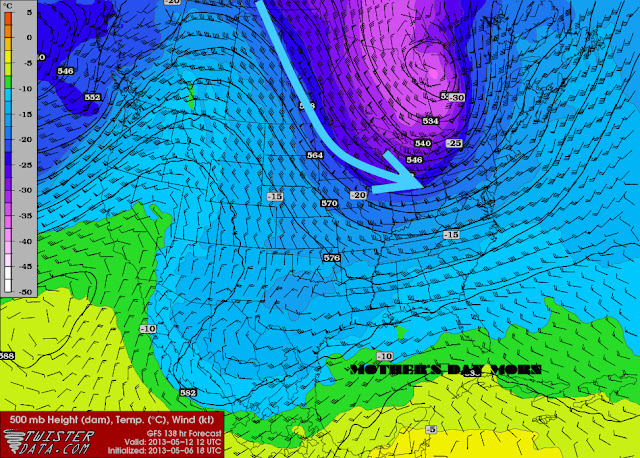
Latest guidance continues the trend for the upcoming weekend into Monday. A rather potent cold front and subsequent air mass will dive across the Great Lakes and on into Southeast Lower on Saturday. Latest temperatures estimates are for lows in the 30s both Mother's Day morning and Monday; while highs drop sharply from the 60s Saturday to the upper 40s to lower 50s on Mother's Day. This is a somewhat impressive mini cold snap; rather sharp and quick hitting for just a couple of days. A brisk northerly wind will accompany the chill on Mother's Day.
For comparison; record low max's for Southeast Lower Michigan on Mother's Day, Sunday are in the lower to mid 40s while record lows on Sunday and Monday are in the upper 20s to lower 30s. Therefore; not too far away from record cold weather for the period.
_____________________________________________________________________
Original blog 5/7/13 1230am
It's interesting how we "backed-out" of winter this past month or so and on into spring.
Very much the same way we backed-out of autumn into winter; late and slowly. In the fall, even with each cooler wave of air it seemed warmer breezes returned and hung around much longer, refusing to give-way to winter. And again; the same thing could be said about spring as the colder, winter-like periods refused to give up the ship to spring.
So what now? Have to serious waves of colder air finally exhausted themselves? Are we free to assume spring air masses will rule the land? While the green-up is now in earnest as expected; is it safe to plant? I'd say yes for the most part BUT there seems to be one more hump to get by before there is more security in that statement. And that hump is the upcoming Mother's Day weekend or in which I'll refer to in meteorological terms and tongue-in-cheek as the "Mother's Day Curse"; or simply when Mother Nature gets to be "Mommy Dearest".
Mother's Day's is always the second Sunday of May which figures out to be anytime from May 8th to May 13th...Julian Day 128 - 133. I've noticed this "pattern" and I can't tell you how many times people complain to me about the "more than occasional" lousy weather on or around Mother's Day in Michigan. Is there any scientific data to back it up? The May 9th, 1923 snowstorm written about in my last blog would certainly fit the bill when Mom Nature certainly had a Mommy Dearest tantrum! How about the general temperatures in DTW data, any note of a pattern during that week or so?
A while back while I was at DTX, we ran DTW's (Detroit Metropolitan Arpt's) climatic data of the high temperatures only from 1958 to 2004, so not the entire Detroit climatic base. And, in this case (as with others) a graph or "picture" is worth a thousand words.
On the graph below we have; the highest category, termed "max" (record highs), "min" (record low maxs), means and standard deviations (%) of all those highs. In other words; the times the temperatures were at a certain standard deviation percentile or below. For example; looking at the graph below say at the 90th percentile at the highlighted interval, means 90 percent of the time the high temperatures either equaled or were less than the particular temperature in the left column. In this particular case, lower 80s are at the 90 percentile and thus, only 10% of the time the highs exceeded the lower 80s.

Again, during the time period mentioned above and highlighted on the graph; one can see the sideways to even down (especially the record low maxs which are shown on the graph as the min trace) of temperatures during the highlighted period, May 8th - 13th (Julian Day 128-133) or Mother's Day date possibilities.
The temperatures actually become a bit more erratic at that time. As mentioned, the most interesting and notable item that shows up is in the record low max's ("min"). See how the bottom blue min data line actually decreases from the first week of May; indicating a several degree slide in the record low maxs as slightly more potent cold air masses occurred during our point of interest - Mother's Day timing, 8th - 13th. Other data (traces) at the same highlighted time show a pause in rising temperatures even though we are proceeding toward the mid May time period. I know it's subtle "pause" but then compare it to the jump in all temperature fields (Max, 90th, 67th, Mean, 33rd, 10th and Min) the next six days from around day 134 to day 139. After; the same pattern roughly repeats all over again up then sideways, up then sideways. The period around Mother's Day happens to fall within that sideways (or even down a bit). Ultimately, the temperature pattern does becomes less variable as we "climb" into summer.
Mother's Day 2013
So, then how does this data relate to the upcoming Mother's Day? For that we have to look ahead at model guidance for our aforementioned period. General model consensus is for a sharpening colder trough to dig out of Canada for the upcoming weekend. The amplitude of this trough and cool surface high pressure to follow will bring colder, below average temperatures during the period roughly Saturday through Monday...or again, right around Mother's Day.


The bigger question at this time (and relating to our headline); will there be a risk of any frost/freeze with this air mass? At this early juncture; I'd say there will be just enough cold air at the surface, that we run the risk of some scattered frost and freezing temperatures but at this time, not a widespread heavy killing frost/freeze. Timing too is important and chilliest mornings are expected at this time to be Mother's Day morning and again, Monday morning.
Therefore make it simple; if you don't have to plant, especially tender vegetation, why risk it? Wait a few days because much warmer weather is projected to follow (sort of like our graph ;-)
Making weather fun while we all learn,
Bill Deedler - SEMI_WeatherHistorian
Bill Deedler - SEMI_WeatherHistorian