Museum marking West Bloomfield tornado 40th anniversary with exhibition March 13th 2016!
March of 1976 opened as a vicious lion and never really lost that image. A crippling ice and snowstorm hit much of Southeast Lower Michigan; especially from Detroit's northern suburbs up into the Saginaw Valley the first several days of the month (see DTW LCD - further below). Then later in the month, the infamous West Bloomfield Tornado an EF4 tornado was spawned that same stormy month. March of 1976 became known for the most tornadoes recorded in the month of March across the country, more on that at the conclusion of this write-up.
While I was employed with the NWS DTX at this time, earlier data collection, long term memory and later further investigation of numerous notable weather events over the decades, brought the specifics on these storms into the forefront as written below.
Ice Storm of March 1976
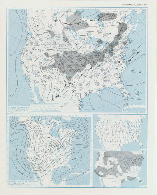
This has been noted as one of the greatest natural disasters to ever hit the state of Michigan. A large area of the Midwest was impacted by this storm, hardest hit was Wisconsin and southern Michigan. Several inches of ice accumulated onto trees and power lines. Over 500,000 people were left without power, some for several days. Many communities also lost such services as water and sewer. Sixteen people in the Midwest were killed by this storm and damages were estimated well into the millions. Several counties in Michigan and Wisconsin were declared disaster areas.It is easy to see why snow, sleet and extended periods of freezing rain focused on the lower to mid Great Lakes as a quasi-stationary front extended for days from the far Southwest into the Great lakes as impulses rippled east northeast along the front. Check out these maps from March 1st-5th as basically, the stalled front caused havoc for the region as moisture was flung northward into the colder air to the north creating the damaging ice storm. The upper wind pattern held parallel along the front with only minor variances for several days. Finally by the 5th; a stronger upper energy vorticity max pushed into the region, dragging a more defined low pressure north of the region, allowing warmer air to surge into the area with temperatures ring into the lower 60s over extreme Southeast Lower Michigan.
Other articles are available from the Ice Storm of March 1976; such as the national guard being called up to help with the widespread damage; also see the devastation on M-live.
WEST BLOOMFIELD TORNADO /EF4/ MARCH 20TH, 1976
The Orchard Lake Museum will mark the West Bloomfield Tornado 40th
Anniversary with a special exhibition from 1-4 p.m. Sunday, March 13. The Orchard Lake Museum is located at 3951 Orchard Lake Road in Orchard Lake.
It was 40 years ago; Saturday March 20th 1976 that the last EF4 tornado was observed in Southeast Lower Michigan and it became to be known as the West Bloomfield Tornado. It was the strongest Oakland County tornado since 1950, touching down in West Bloomfield, according to the National Weather Service at DTW /Detroit Metro Airport/ at that time. This tornado resulted in one death and 55 injuries. It was categorized as an EF4 on the enhanced Fujita scale. A mobile home, 91 homes, 23 businesses, and around 25 automobiles were either destroyed or damaged from the tornado. With total damage of more than $5 million, this tornado also ranks as the costliest tornado in Oakland County. A super-cell thunderstorm developed over Oakland county with the EF4 tornado forming near Halsted Rd between 13 and 14 Mile Rd at 715 pm EST. The peak of the damage was centered around the Orchard Lake/Maple Road intersection; and then dissipating just east of Middlebelt Road. Then at
7:40pm EST; an EF3 formed and touched down further northeast in Macomb County near 26 Mile Rd and Romeo Plank in Ray Township. This storm killed 1 and injured 3 while doing $250,000 dollars in damage. Those were just two of 68 tornadoes that were ignited by super-cell thunderstorms by the clashing of the air masses, March 20-21, 1976.
Though I'd been in the NWS a couple of years; I can't recall whether I worked that day or not like some of the other notable weather events that have hit the region. I do recall that March of 1976 had averaged unseasonably mild (Fig -1) and was intermittently stormy with wild fluctuations in temperatures (as discussed above in the Ice Storm section) resulting in more weather extremes, at times. Note, the ongoing extreme high and low temperature volatility around the day of the tornado as spring air masses clashed with the late winter air masses (Fig -2). It's also interesting to note that the atmosphere was on the tail end of a double, moderate to strong La Nina during that particular early spring period. La Nina's tend to encourage severe weather and tornadic outbreaks.
1973
|
1.7
|
1.2
|
0.6
|
0
|
-0.4
|
-0.8
|
-1.0
|
-1.2
|
-1.4
|
-1.7
|
-1.9
|
-1.9
|
1974
|
-1.7
|
-1.5
|
-1.2
|
-1.0
|
-0.9
|
-0.8
|
-0.6
|
-0.4
|
-0.4
|
-0.6
|
-0.7
|
-0.6
|
1975
|
-0.5
|
-0.5
|
-0.6
|
-0.6
|
-0.7
|
-0.8
|
-1.0
|
-1.1
|
-1.3
|
-1.4
|
-1.5
|
-1.6
|
1976
|
-1.5
|
-1.1
|
-0.7
|
-0.4
|
-0.3
|
-0.1
|
0.1
|
0.3
|
0.5
|
0.7
|
0.8
|
0.8
|
FIG - 1

FIG - 2
March 17th-22nd, 1976

Temperatures for the month average over five degrees /5.1/ above normal with temperatures rising into the 70s that day. Another sideline interesting fact was the official rainfall for that date /20th/ was just a trace a DTW - Detroit Metro Airport. Note the temperature fluctuations in and around that date below in the monthly LCD (enlarged below) in which the conflicting air masses affecting the region at that time were recorded on the F6 LCD. A low of 14 degrees on St. Patty's Day /17th/ only to rebound to 70 two days later on the 19th! Then after that horrible tornado event; temperatures plummeted again with a tenth of snow the next day on the 21st with a low of 21 and then, back to the teens /16/ on the 22nd.
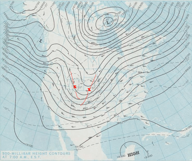
500 MB Saturday Morning 3/20/76
Strong upper level dynamics /vorticity maximums/ over the western Plains were approaching the Great Lakes while a 50 knot wind jet was already in place over the region that morning.
Early Afternoon Surface Map Saturday 3/20/76
By early afternoon; temperatures were already some 20 degrees above the normal highs /upper 40s/ with the upper 60s over Southeast Lower Michigan, while dew points rose into the lower to mid 50s. More importantly; further south over the southern Indiana/Illinois region, dew points had surged into the lower 60s enhancing instability with temperatures pushing into the 70s. This was the air mass heading into Southeast Lower Michigan later that day and evening. A strong cold front was approaching the region and with the air mass in place and what was expected to flood into Southeast Lower Michigan later that day; a Tornado Watch was issued later that afternoon. There were no tornado sirens in place at that time and if memory serves; the West Bloomfield Tornado was instrumental in getting them placed across Oakland County!
Note the upper air radiosonde from the WSO NWS Flint (upper air site at the time) that morning.
The shear in the atmosphere (among other things, needed for tornadic outbreak to create the spin in the column of air) was well profiled with low level south winds veering and increasing with height to the southwest and then west southwest to 50 Knots @ 500 MB /18,000 Ft/.
The upper wind data as of evening of March 20th at 500 MB /18kft/
Under the UCAR COMET program, we can see the modified sounding around Pontiac at 00Z /7 PM EST/ below that evening around the times of the tornadoes. Cooling aloft increased the instability while the upper winds continue to show shear with a helecity of 458m2/s2 which is very favorable for strong super-cell tornadic development! As we know, an EF 4 /West Bloomfield/ and an EF 3 /Ray Township/ were spawned that day among numerous others across the
Studies looked at the use of helicity for forecasting the risk of tornadoes.
Helicity 150-299 ... weak tornadoes (possible super-cell)
Helicity 300-499 ... strong tornadoes (favorable for super-cell development)
Helicity > 450 ... violent tornadoes
More:
Numerous pictures of the tornado damage are available at the West Bloomfield Library online; here .
See personal video accounts of this unusual balmy, stormy day here
Severe weather climatology and stats for DTX since 1980
Next up later this month; looking at the Winter of 2015-16, the second warmest on record at both Flint and Saginaw; the fifth warmest at Detroit. Did Mom Nature behave herself and follow the pattern expected from the Winter Outlook study for strong El Ninos?
| Top 20 Coldest/Warmest Winters in Southeast Lower Michigan | ||||||||||||
| Rank | Detroit Area* | Flint Bishop** | Saginaw Area*** | |||||||||
| Coldest | Warmest | Coldest | Warmest | Coldest | Warmest | |||||||
| Temp | Year | Temp | Year | Temp | Year | Temp | Year | Temp | Year | Temp | Year | |
| 1 | 18.8 | 1903-1904 | 36.9 | 1881-1882 | 16.7 | 1976-1977 | 33.4 | 1931-1932 | 15.7 | 1962-1963 | 33.3 | 1931-1932 |
| 2 | 19.3 | 1874-1875 | 35.7 | 1931-1932 | 17.0 | 1962-1963 | 33.0 | 2015-2016 | 16.5 | 1917-1918 | 31.7 | 2015-2016 |
| 3 | 19.7 | 1976-1977 | 35.2 | 1889-1890 | 17.8 | 1958-1959 | 32.2 | 1982-1983 | 16.6 | 1919-1920 | 30.9 | 1997-1998 |
| 4 | 19.7 | 1917-1918 | 33.8 | 2001-2002 | 18.6 | 1978-1979 | 31.7 | 2001-2002 | 17.5 | 1978-1979 | 30.6 | 2011-2012 |
| 5 | 20.4 | 1962-1963 | 33.8 | 1997-1998 | 19.0 | 2013-2014 | 31.3 | 1997-1998 | 18.0 | 1977-1978 | 30.5 | 2001-2002 |
| 6 | 20.6 | 1977-1978 | 33.5 | 2015-2016 | 19.3 | 1977-1978 | 31.2 | 2011-2012 | 18.2 | 1976-1977 | 30.0 | 1936-1937 |
| 7 | 20.8 | 1919-1920 | 33.0 | 2011-2012 | 19.8 | 1993-1994 | 30.3 | 1932-1933 | 18.2 | 2013-2014 | 29.6 | 1982-1983 |
| 8 | 20.9 | 2013-2014 | 32.5 | 1982-1983 | 19.9 | 1944-1945 | 29.1 | 1952-1953 | 18.2 | 1958-1959 | 29.5 | 1920-1921 |
| 9 | 21.0 | 1935-1936 | 32.5 | 1879-1880 | 20.9 | 1981-1982 | 28.8 | 1936-1937 | 18.7 | 1935-1936 | 29.0 | 1918-1919 |
| 10 | 21.1 | 1892-1893 | 32.3 | 1918-1919 | 21.2 | 1935-1936 | 28.6 | 1948-1949 | 19.0 | 1993-1994 | 28.8 | 1932-1933 |
Making weather fun while we all learn,
Bill Deedler -SEMI_WeatherHistorian


