Originally; the record low temperatures were in a 6-day stretch until a few years ago; when on November 18th, 2014 the mercury fell to 11 degrees and superseded (by date only) the 11 set in 1880. By the way; that cold snap back five years ago has some similarities to our present one...read about it here.
Record
November Cold Wave Holds Steadfast For Well Over a Century
By: Bill Deedler, Southeast Michigan Weather
Historian (originally written Nov 2006 and updated with new information
11/12/2019)
Nothing
in Southeast Michigan ’s record books has anything close to the record
cold wave that occurred so early in the cold season than way back in
the late 19th century in November 1880, or 139 years ago! The
bitter cold surges blasted Southeast Lower Michigan from the 17th to the
25th from the Arctic region and engulfed much of the country. The Arctic
chill came down in the form of two impressively strong Arctic high pressure
systems (see maps below) for mid winter, let alone mid November.
Below is the record chart for that period that
contains both the record low maximums
and record lows that occurred
during the November cold wave which left five days of consecutive record
low records that have not been touched since! The three degree reading on
the 21st and zero on the 22nd have yet to be superseded by colder temperatures
in the entire month of November. A zero (or below) record low does not
appear in Detroit ’s record lows for another 10 days when a -2 was recorded on
December 2nd, 1976!
Again,
not only is the cold impressive but the seven record low maximums and five
consecutive record lows have not been breached since this cold
wave! So what caused this bone-chilling cold so early in the season,
what did the weather maps (or best representation of) look like so far back?
Let’s take a look at copies of the archaic weather map records from Nov 18-23,
1880 which shows the couple of mammoth Arctic high pressure systems that
affected much of the during the period.
NOVEMBER 1880 COLD
WAVE
Date Rec Low Max Rec Low
17
|
48
|
34
|
41.0
|
70/1953
|
22/1880
|
56/1931
|
13/1959
|
18
|
48
|
34
|
41.0
|
73/2016
|
18/1880
|
56/2015
|
11/2014
|
19
|
47
|
33
|
40.0
|
68/1985
|
22/1880
|
58/1985
|
9/1880
|
20
|
47
|
33
|
40.0
|
70/1942
|
25/1914
|
57/1913
|
12/1880
|
21
|
46
|
33
|
39.0
|
67/1913
|
12/1880
|
56/1931
|
3/1880
|
22
|
46
|
32
|
39.0
|
69/1913
|
16/1880
|
57/2010
|
0/1880
|
23
|
45
|
32
|
38.0
|
69/1931
|
21/1880
|
57/1931
|
8/1880
|
24
|
45
|
32
|
38.0
|
62/2001
|
17/1950
|
53/1966
|
7/1950
|
25
|
44
|
31
|
38.0
|
63/2001
|
23/1880
|
50/1908
|
10/1950
|
NOVEMBER 1880
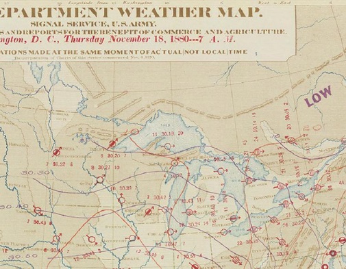
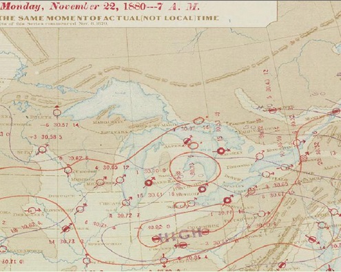
As of 7AM - Thu Nov 18th Note the first big chunk of cold dense air is well reflected by the exceptionally high pressure for November (not to mention over the southern states) in eastern Oklahoma of 30.78" /1042.MB/ (just at the bottom edge of our map). This massive Arctic high made its way south out of the Northern Plains and as a result, temperatures across much of the region were in the single digits and teens.
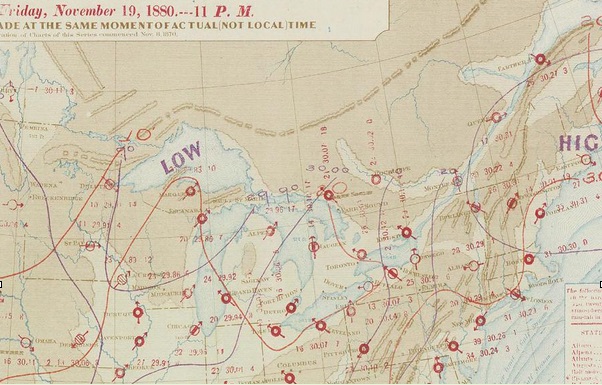
As of 11PM - Nov 19th By late Friday night, a new surge of Arctic air is beginning to show its face here as a new low pressure trough enters the Upper Midwest and Great Lakes Region. Note, temperatures haven’t had a chance to recover much from the first bitter cold blast!
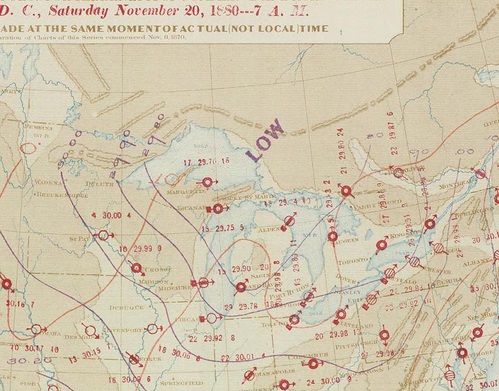
As of 11PM - Nov 20th The second surge of fresh Arctic air continues advancing across the Great Lakes and Ohio Valley as general high pressure holds over the southern states.
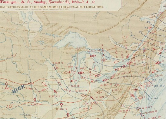
As of 11PM - Nov 21st A second, duplicate strong high pressure appears on our map, once again by way of the Northern Plains and expands south and east into into the Upper Mississippi Valley and Great Lakes. Low pressure troughing holds sway over the relatively warmer waters of the Great Lakes (estimates of water temperatures in the mid 30s to mid 40s). Temperatures have plummeted below zero already in the Upper Mississippi Valley by late Sunday night.
As of 11PM - Nov 22nd A huge bitter cold high pressure lies spralled across the Ohio Valley and Great Lakes with a central pressure of 30.85" /1045 MB/! The public continues to be greated by record cold as the Thanksgiving work week commenced across the nation. The 30.85" was a record high pressure at the time (and may be yet) for Cincinnati, Ohio. Besides our own, numerous other record lows were attained with the passage of these Arctic highs.
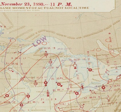
As of 11PM - Nov 23rd The large high pressure moves ever so slowly east with the central high pressure now over the mid Atlantic States.
Evidently this was not the first notable November cold snap that engulfed the region so early in the weather record days. The following was taken from the 1880 Monthly Weather Review:
"The passage of of this area was marked by minimum temperatures for the Lakes region, the Atlantic States, the Ohio, Upper Mississippi and Lower Missouri valleys. They occurred from seven to eight days earlier in the month than the remarkably low temperatures of 1875. The most notable temperatures observed at the Signal Service Stations were Washington, 12.5; Philadelphia, 10; St. Louis and Louisville, 8; Pittsburg, 4; Buffalo, 3; Chicago, 1; Erie, Detroit, Sandusky, Grand Haven and Des Moines, 0; Champaign, -3; Alpena, -4; Columbus, Indianapolis, Keokuk and Milwaukee, -5; Port Huron, -6; Marquette, -9."
As mentioned, all the Detroit records should remain intact 139 years later and I wonder how many others are still around at other offices?
Yes; I know the Winter Outlook seems overdue now that we got clobbered by snow and now cold. I look to release it within the next week (which is generally the time-frame). One of the most gratifying results found thus far in the analogues was the amount of snowy and cold Novembers -right on cue!
Making weather fun while we all learn,
Bill Deedler -SEMI_WeatherHistorian
Bill Deedler -SEMI_WeatherHistorian