Local Data Suggests
Temperatures: Normal to Above
Expect temperatures during the 2016-2017 winter to be more variable
than usual with conflicting data in research. This will be due to a variable upper wind jet stream. I look for
both a split flow and phasing of jets as much over the Central and Western US as in the East. Guidance and Analogues suggest the heart of the winter /Jan-Feb/ seeing the most of the action (though that doesn't mean there won't be any, other times) but winters tended to start somewhat later than average (see more in Analogues). This will be guided by the anticipated weak La Nina
to Neutral state interacting with the North Atlantic and subset Arctic
Oscillation /NAO, AO/. Just as important this winter will be the Pacific Decadal Oscillation /PDO/ and associated Eastern Pacific Oscillation /EPO/.
In the final analysis,
I look for the Southeast
Lower Michigan
winter to average around normal to above normal. Temperature departures should average from -1.0F to + 2.0F.
Actually, expanding
on this “normal” idea, it is interesting to note that the 100 year winter mean
temperature for Detroit is approximately 26.7 degrees with a one standard
deviation spread of 3.5 degrees either side of that 26.7. Statistically
speaking, based on this data the temperatures could average as low 23.2
degrees or as high as 30.2 and still be considered within a “normal” range of
the 100 year mean. The 30 year mean at Detroit has risen appreciably over earlier averages, mainly due to the local urban heat island. That winter average /1981-2010/ now rests at 27.9, a full degree /1.2/ above the old 100 year.
This
outlook hinges mainly on the endurance of the Pacific jet and its extensive eastward push and its interaction with the polar and Arctic jets.
Normally during La Nina, the more dominant jet is the polar and/or Arctic jet leading to colder than normal
temperatures. However, I feel this winter will see more interaction with the
Pacific jet stream jet, a lay-over of sorts, if you will, from El Nino and the warm PDO (discussed at length, below). These variables, combined at times with the Polar Vortex over central and western Canada, supports this variable
forecast. I see this hindering the dominance of below normal temperatures this
winter. More on the jet structures in the storm track section.Snowfall and Rainfall: Normal to Above depending on location
Because of the temperature variability and associated storm tracks observed in many of the
analogue winters, snowfall in those winters ranged widely from above
normal to below. This would be expected since the variance of temperatures
hint at the variability of the upper atmospheric patterns and storm tracks.
Therefore, pinpointing the perceived prevailing storm tracks this
winter will make a significant difference in regard to seasonal snowfall.
Using the expected dominant storm tracks for the upcoming winter, it is likely much of the region will experience normal to above normal precipitation with above normal snowfall /5.0"+/ around Detroit's northern and western suburbs north into the Flint and Saginaw Valley; to around normal /within 5.0"/ over the far Southeast corner of Lower Michigan (south of Detroit). Mixed precipitation events seem to be a higher than normal risk.
Using the expected dominant storm tracks for the upcoming winter, it is likely much of the region will experience normal to above normal precipitation with above normal snowfall /5.0"+/ around Detroit's northern and western suburbs north into the Flint and Saginaw Valley; to around normal /within 5.0"/ over the far Southeast corner of Lower Michigan (south of Detroit). Mixed precipitation events seem to be a higher than normal risk.
Broad Scale Discussion
An interesting and another challenging winter is ahead with three
main climate and weather drivers, a generally weak La Nina to Neutral conditions, the illusive NAO and PDO, working together to
bring Southeast Lower Michigan a fairly interesting winter.
1 - La Nina
The difference between the current developing La Nina to the last La Nina is the strength and timing. The
last La Nina was very strong compared to the current developing La Nina's
strength.
Current Developing La Nina as early November

Past La Nina stage as of November 2010

The strength of the previous La Nina 2010-11 is quite evident by the below normal SST's dipping to -2.0C as opposed this winter's expected ~ -.7C to -1.1C
October 2016 Average SST's

Multivariate ENSO Index 1950 - early 2016 shows up to the strong El Nino of the past year and note the strong La Nina during the Winter of 2010-11.

The Southern Oscillation Index /SOI/ below shows well the recent negative corresponding values in conjunction to our recent strong El Nino. Remember; an above normal SST is reflective of a negative SOI.

Latest Modeling Projections of the expected weak La Nina to Neutral conditions

Corresponding Analogue Years by SOI values (positive = La Nina)
(only numerical values for the first two analogues available)
SOI 1878-79
1878 4 -8.2 1
1878 5 2.5 4
1878 6 -3.2 5
1878 7 14.8 4
1878 8 12.4 2
1878 9 17.5 2
1878 10 11.7 2
1878 11 14.4 2
1878 12 16.6 2
1879 1 12.1 2
1879 2 14.1 2
1879 3 10.8 2
1879 4 10.9 2
Available SOI Graphs below from analogues years reflect Neutral to ModerateSOI 1889-901889 4 -0.8 41889 5 -1.2 51889 6 18.4 41889 7 1.4 31889 8 2.1 51889 9 11.1 41889 10 4.7 21889 11 22.0 41889 12 20.7 21890 1 20.3 21890 2 10.6 21890 3 11.8 21890 4 5.7 2
La Ninas after strong El Ninos.


Latest SOI data through October shows a Neutral to weak La Nina state

2-Pacific Decadal Oscillation /PDO/ and associated subset EPO
The Pacific Decadal Oscillation remains in the recently switched warm phase, changing over a year ago. A warm phase of the PDO is represented on the left of the following example and compare it to the current state.
Warm Phase of the PDO Cool Phase of the PDO

Current Warm Phase of the PDO and weak La Nina show well in this recent SST scan on November 6th, 2016. Generally warm phases coincide with El Nino's or Neutral states and rarely La Nina states. It does happen and we have two winters in the current analogues when such an occurrence happened like the present time (and their subsequent winters were our coldest). Studies propose that when the PDO and ENSO are out of phase; which is a somewhat a rare event, that they may cancel out their known effects. Keep this in mind when looking at the Analogues.
"The Pacific Decadal
Oscillation (PDO) is a pattern of Pacific climate variability similar to
ENSO in character, but which varies over a much longer time scale. The
PDO can remain in the same phase for 20 to 30 years, while ENSO cycles
typically only last 6 to 18 months. The PDO, like ENSO, consists of a
warm and cool phase which alters upper level atmospheric winds. Shifts
in the PDO phase can have significant implications for global climate,
affecting Pacific and Atlantic hurricane activity, droughts and flooding
around the Pacific basin, the productivity of marine ecosystems, and
global land temperature patterns. Experts also believe the PDO can
intensify or diminish the impacts of ENSO according to its phase. If
both ENSO and the PDO are in the same phase, it is believed that El
Niño/La Nina impacts may be magnified. Conversely, if ENSO and the PDO
are out of phase, it has been proposed that they may offset one another,
preventing "true" ENSO impacts from occurring".

"Odd-ball" Pacific SST Analogue Winters
There were only two winters in this winter's outlook research that contained a warm state PDO while the La Nina developed and prevailed; the Winter of 1878-79 and 1983-84. The 1878-79 La Nina winter was fairly weak while the 1983-84 La Nina winter was a bit more developed. Curiously, those two winters were our coldest in this season's analogues.


3-North Atlantic/Arctic Oscillation /NAO & AO/
One of the most important players for winter's outcome and ingredients in this winter’s weather is
the trend of the North Atlantic Oscillation/Arctic Oscillation (NAO/AO). This
is the biggest challenge to the forecast and potentially has the biggest bust
potential. While trends with La Ninas and El Ninos are relatively stable, the
NAO is highly elusive and trends are seen only a week or two in advance.
Generally, colder winters in the study occurred with a predominately negative
NAO. Below is a graph of the NAO in its positive and negative phases with arrows denoting the analogue years in in this winter's study.

Projections of this winter's NAO/AO are variable. One scientist who bases NAO/AO trend expectations and subsequent winter temperatures, Judah Cohen , strongly bases the winter temperature projection on early snowfall across Eurasia along with sea ice coverage in the early Autumn. His research has shown that these variables affect the NAO/AO development and positioning.. At this time with higher than normal snowfall coverage in that area and weaker ice formation in the Arctic this fall, projections are for a colder winter for almost all of the eastern U.S (excepting New England). Mr. Cohen has a nice update here every week or so on current and expected trends.


Projections of this winter's NAO/AO are variable. One scientist who bases NAO/AO trend expectations and subsequent winter temperatures, Judah Cohen , strongly bases the winter temperature projection on early snowfall across Eurasia along with sea ice coverage in the early Autumn. His research has shown that these variables affect the NAO/AO development and positioning.. At this time with higher than normal snowfall coverage in that area and weaker ice formation in the Arctic this fall, projections are for a colder winter for almost all of the eastern U.S (excepting New England). Mr. Cohen has a nice update here every week or so on current and expected trends.

4-Solar cycle
Solar cycle actual effects on short term weather and longer term climate variability remain a controversial subject. I've read several articles which support or are against their shorter term winter relevancy. Some theorize that both natural solar cycles and man's influence affect our climate. I am in favor of the solar cycle being somewhat relevant and sometimes giving the present winter cycle a "little kick" in regard to hemispheric wind flow patterns and resulting temperatures. Studies out of Europe for example, do in fact make the connection to wintertime effects.
"The Euro–Atlantic sector seems to be a region with a par-
ticularly strong solar influence on the troposphere. In fact,
significant positive correlations between solar activity and
surface temperature in Europe have been reported in several
papers (e.g. Tung and Camp, 2008; Lean and Rind, 2008;
Lockwood et al., 2010; Woollings et al., 2010), although
long records tend to give very weak signals (van Olden-
borgh et al., 2013). We found a weak but significant change
in the mean late winter circulation over Europe, which re-
sults in detectable impacts on the near-surface climate. Fig-
ure 9 suggests that during solar minima more cold air is ad-
vected from the Arctic, thus resulting in a slightly increased
probability of colder winters for large parts of the conti-
nent. Sirocko et al. (2012) recently reached the same con-
clusion after analysing 140 yr in 20CR, although their re-
sults are strongly dependent on their selection criteria for
the solar minimum composite (van Oldenborgh et al., 2013),
which includes only one winter for each solar cycle".
Comparing solar cycles of the past analogue winters to the present as a possible influence only and not a major contributor. While the solar cycle was in various modes, the tendency is for these La Nina's to Neutral winters to occur during the mid to lower part of the cycle or during an overall, weaker cycle (like the one we have entered, below).

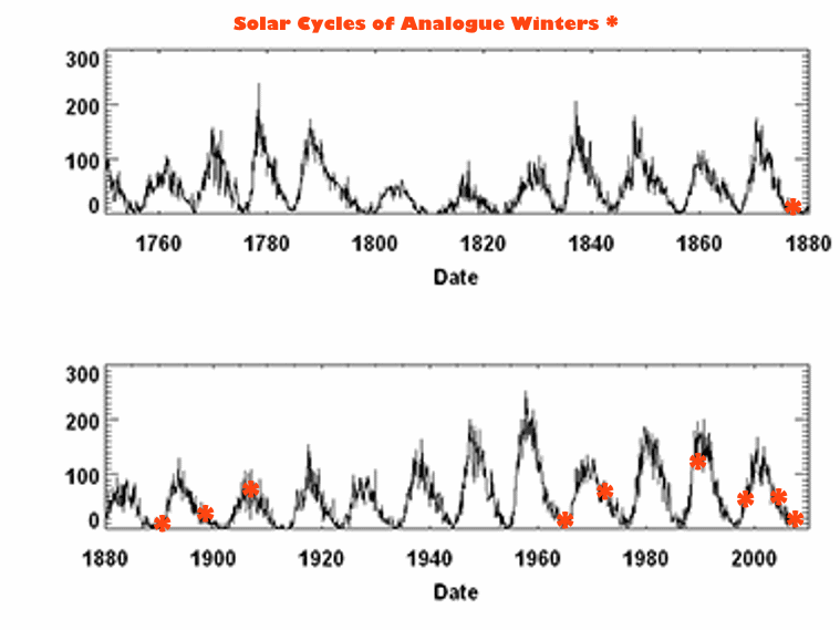
Here we see the latest solar cycle amplitude compared to the previous cycles back to the mid 1970s.

Winter 2016-17 Analogues
(click on table to enlarge)

Analogue Research and Results
As stated above, the analogue years were quite variable but with a tendency toward below normal temperatures. Remember, looking at Detroit alone, you run into the influenced heat island normals, which then would tend to skew the averages below normal slightly, since they are warmer (than the 100 year) - get it? Anyway, all three cities suggest a normal winter when the variances are averaged. Looking at the individual winters, there still remains a preference for a below normal winter. Winter's were most active mid to late winter, with the highest snowfalls mid winter. Looking at December's alone; suggests that the winters (notable snows) started generally mid to late month, somewhat later than average. Back to the entire winter; the second preference was for a normal winter and the least was for an above normal. This certainly fits La Nina winters but we are not dealing with just a La Nina winter. The analogues represent quite a range Neutral to moderate La Ninas and still I was only able to find 11 that match the past strong El Nino melding into a Neutral to moderate La Nina by the next winter season.
Even with the dominant normal to below normal winters; there were a decent showing of above normal winters, enough to pull the averages back to near normal. As mentioned above, the coldest winters were found when the rare warm PDO existed above the cool La Nina, as in this present year. Studies have found this tends to dampen the effects of the La Nina.

The split in the temperature pattern (above normal Southeast to below North) is well displayed during the analogue years

In addition with the conflicting and variable types of air masses in the same location, note heavier precipitation in the battle zone below.

Winter 2016-17 Upper Wind Anomalies & Projected Storm Tracks
Compare the typical jet structure of the La Nina below with the analogue years depicted jet and anomalies in the following section:

The upper wind anomaly pattern from all analogue winters shows a marked difference in jet preferences and placing upper Lows and ridging when compared to a typical La Nina pattern. While the semi-permanent eastern Canadian Low is represented by the lobe of negative anomalies south of Hudson & James Bays; the most predominate departures in the upper wind anomalies materialized over western Canada and the Northwestern US. It's almost like the typical La Nina upper wind trough pattern shifts back west at times and creates the negative departures over that region. Referring to the typical La Nina map (above), the ridging is dominant on the West Coast of Canada and to a lesser extent, the US which would negate the coldest of winters.

The mean (an average) upper wind flow for the analogue years is shown below but nevertheless, still intimates weak troughing from the Aleutian Low south-southeast to the Desert Southwest. This suggests the phasing of the upper low impulses dropping southeast from Alaska and western Canada and thus, giving "birth" to a more pronounced western US trough at times. Again, this extended troughing from western Canada and into the US is displayed nicely by the analogue composite anomaly map, above.

Resulting Storm Tracks This Winter
Main upper air feature positions along with generated storm tracks by my analysis per analogue data is on the map below. The upper lows and troughs are depicted in black; while the resulting storm tracks are in red. As you can see, the generated storm tracks to our southwest are mainly Kansas and Texas Panhandle Lows which have a tendency to track near or over Southeast Lower Michigan. If the impulse generated is far enough south, some Arkansas or even Louisiana lows are possible but they are not expected to be a main player this winter. East Coast storms should be more the result of Ohio Valley and mid Atlantic phasing.

What do the models have to say about the winter? Mild to warm everywhere if you look as of November 2016

For December
NMME IMME


Prob fcst |
PAC calib. prob fcst |
|---|
NCEP_CFSv2 |
CMC1_CanCM3 |
CMC2_CanCM4 |
|---|
 |
|---|
GFDL_CM2.1 |
NCAR_CCSM4 |
NASA_GEOS5 |
|---|
| NCAR_CESM | IMME |
|---|

Forecasted precipitation trends for the winter generally follow the analogue years trend

NMME

Prob fcst |
PAC calib. prob fcst |
|---|
NCEP_CFSv2 |
CMC1_CanCM3 |
CMC2_CanCM4 |
GFDL_FLOR |
|---|
GFDL_CM2.1 |
NCAR_CCSM4 |
NASA_GEOS5 |
NCAR_CESM |
|---|
IMME

I'll be back at times when notable storms and/or temperature changes are expected to affect the region along with other historic storm information for the winter!
Making weather fun while we all learn,
Bill Deedler - SEMI_WeatherHistorian