Summer of 2022 was a warm and rather quiet summer weather-wise with generally below normal to just scattered patches of normal rainfall. There even was a preponderance of nice, comfortable warm days with considerable sunshine through the summer along with each month containing just a handful of hot, sticky days and muggy nights. With lack of high instability, strong jets and proper frontal timing the severe weather risk was routinely cut back across Southeast Lower Michigan. Much of the rough stuff was concentrated over the upper Midwest into the Western Great Lakes and then again; across the Northern Ohio Valley and points south. The upper jet, instability and frontal timing seldom came together a major outbreak (I'm sure severe weather buffs wouldn't be so generous in rating the summer). In fact; the really only major, widespread outbreak came late in the summer season as August was ending. And I will say; while severe weather was certainly limited this season thus far; the late summer squall on August 29th ended the summer with a bang. This was also the last time notable, widespread beneficial rains moved through Southeast Lower Michigan. Even thus far in September, heaviest rains with an upper low/surface low fell mainly west of Southeast Lower Michigan.
Late Summer Squall on 8/29/22 from DTX
https://www.weather.gov/images/dtx/events/2022/August/August%2029/RadarLoop.gif

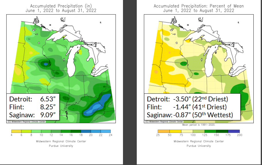
While on the rainfall totals of the summer; lets look at the totals around SE Michigan at the three main climate sites and a smattering of our co-ops.


Temperatures across the region were warm but were kept in check by the expected upper flow in Canada bringing a round of cool fronts into the area. Many fronts passed early in the day, overnight or were backdoor fronts bringing just intermittent rains. Most areas received below normal precipitation in Southeast Lower Michigan with rainfall more concentrated over South-Central and Western Lower Michigan and points south into the Ohio Valley.
In and around Metro Detroit Summer 2022
The summer started out with quite a difference between the city at Detroit City Arpt /DET/ compared to Detroit Metro Arpt /DTW/ in June due to **heavy rains in thunderstorms and rainfall early-mid June that popped DET's June rainfall total above normal at 4.17''. At the same time in June, Detroit Metro was well below normal with almost half as much rain with just 2.15"
** DET /Detroit City Arpt/

In the final analysis; the Detroit Metro area summer rainfall was generally less below normal in the city and the northern-northwest suburbs. However; the official summer rainfall further south out at DTW was a paltry 6.53" or three and a half inches /-3.50/ below average...making it 22nd driest, just missing the top 20 driest. Downtown Detroit dried out with much of the rest of Southeast Michigan in July and August but still managed a respectable 8.03" for summer rains.
I guess I should have stuck more with my analogues as far as rainfall in which they plotted a normal to below normal rainfall summer with an average departure of all years of -0.71" of rainfall. But in fairness to myself, a normal or typical summer rains was still the highest indicator/summers in the analogies. From the Summer rainfall projection...
Rainfall Outlook
Though analogues display a slightly drier summer when all data is considered; in following the overall recent rainfall patterns, a normal to wetter summer is more likely.
Reasonable Seasonable Temperatures
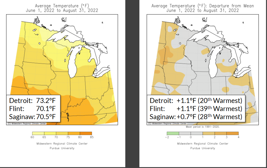
As stated earlier; it was an overall nice, warm summer especially as we advanced through the summer into August. Both June and July averaged slightly above normal over all of Southeast Lower Michigan /within our analogue 1.0 degree/ with August averaging above normal at 1.0 - 2.0 degrees. Using the three climate stations; the summer average in Southeast Lower Michigan was 1.0 above normal. /+0.96/ at 71.26 degrees. This came well within the Summer Outlook forecast range of /-1.0>+1.5/ for the summer. The anticipated semi-permanent upper low over central - eastern Canada did indeed routinely pivot cold fronts followed by attending cooler air masses south into the Great Lakes and Northeast. At times, especially early-mid summer these fronts made it well south into the Ohio Valley (spawning flooding rains as they stalled).
Routinely popped into the 90s
All regions totaled just an extra one or two 90s typically felt for the year thus far - but plenty of 80s. This one or two extra 90s matched well to the slightly above normal summer temperatures in statistics. Detroit received 15 days of 90 or above during the warm season thus far, Flint totaled 10 thus far and Saginaw 6 days of 90 or better. One has to remember Detroit's heat island aids somewhat in positive departures with temperatures, especially overnight lows.
Temperature Outlook from Summer Outlook:
I
look for the summer to average around normal or -1.0 to +1.5 degrees of
the new 1991-2020 normals in Southeast Lower Michigan. The summer seems
to be shaping up to be a more changeable summer than is typical in both
temperature ranges and weather patterns. The push of cooler air from
Canada should offset most hotter spells from the south.
Making weather fun while we all
learn,
Bill Deedler
- SEMI_WeatherHistorian