3/24/12

Freezing Temperatures Cause Havoc to Some Vulnerable Vegetation and Fruit Trees in Southeast Lower Michigan - 3/27/2012

Compared to the heat of last week, it was a very cold night across Southeast Lower Michigan with temperatures plummeting into mainly the 20s to around 30. And; with just last week's high temperatures being in the 80s, mom nature has certainly thrown a curve ball at vulnerable vegetation! As an example; my huge formally beautiful magnolia now carries little brown canopies of death. Of course, magnolias are always vulnerable to spring cold snaps being their home-base is in the South but more importantly; talking with Bob Tritten from Michigan State's University Agriculture Extension program; "last night's below freezing temperatures that befell Southeast Lower Michigan, lasted for up to 12 hours! And, damages to early sprouting fruit trees are now being assessed and significant losses are possible."

Actual overnight low temperatures are available from the NWS from the Regional Temperature Precipitation Summary and also again, from Michigan State's University Enviro-weather web site. Just go to the site, run your mouse cursor over the yellow dots on the map and current weather observations will pop-up; along with a host of weather and soil conditions when you click on individual highlighted topics.

While some moderation is expected in temperatures the next day or so,  colder (30s) weather is again likely Thursday morning but not as cold as this morning.
 Making weather fun while we all learn;
 Bill Deedler - SEMI_WeatherHistorian

-------------------------------------------------------------------------------------------
I first noted in my last blog; the risk of frost and freezing temperatures is still high this time of year. In addition; I stated "A large polar high pressure system will stick its beak down into the Great Lakes and points east early next week and bring quite a change from the summer-like weather we've recently felt! How far south the colder air is able to infiltrate the area remains to be seen; so stay tuned".


The "cold snap" remains on track as the Polar High moves across Southern Ontario and the Great Lakes into Tuesday. Little change is anticipated this Monday afternoon as the expected lows last night came to fruition and the most vulnerable time period will be tonight into Tuesday morning. Temperatures last night fell into the upper 20s to near 40 around the Lakes. I expect readings tonight to fall mainly into 20s to lower 30s with again; the warmest near the Lakes and larger cities. A widespread killing frost and freeze is expected by Tuesday morning. Dew point temperatures this afternoon reflect the cold, dryness of the air mass with many being in the teens and 20s! With dew points so low, even a few upper teens for overnight lows may be realized.


Some of the new tender vegetation will be at risk with the colder weather; particularly since it came out so early this season. Also, nursery's and home gardens who set out plants may want to keep a close tab on the expected low temperatures for your immediate area.

Making weather fun while we all learn;Bill Deedler - SEMI_WeatherHistorian

3/20/12

Hot Hot! Mother Nature's Giving It All She's Got; But How Long Will It Last? /updated 3/22/2012/

As I continue work in my yard; I see vegetation growing that is clearly weeks ahead of schedule...Magnolia in full bloom (about a month ahead)...numerous flowering bushes 3-4 weeks ahead (next thing you know; the lilacs will start their flower buds...a good 4-5 weeks ahead as they usually bloom late April into early May). This is insane and the unprecedented summer-like heat continues as once again; temperatures are broaching the 80 degree mark easily today (3/22/2012). All trees, deciduous and fruit, are rapidly budding and growing out now! For more on the unprecedented warm to hot March pattern including agricultural interests; see here for further details.

While it's beautiful summer-like weather now; (unfortunately I have to admit, I cranked on the air-conditioning for a short while yesterday and any money saved on heating bills this past winter will fly out the window with air conditioning) it could prove devastating for garden and agricultural interests were there to be a hard freeze and frost. I'm sorry to say; a frost or freeze is highly likely yet along with even the risk of snow. We still have 3 to 4 weeks we have to squeak through before the risk begins to drop off; precipitately.

Our first real cool-down to watch is expected late in the weekend into early next week! Our latest models (3/22/2012) are disagreeing on the extent of the cool down but this one will definitely have to be watched!  A large polar high pressure system will stick its beak down into the Great Lakes and points east early next week and bring quite a change from the summer-like weather we've recently felt! How far south the colder air is able to infiltrate the area remains to be seen; so stay tuned.


Making weather fun while we all learn; 
Bill Deedler - SEMI_WeatherHistorian

(previous blog from 3/20/2012)
A record, summer-like upper level ridge of high pressure continues to dominate the eastern half of the nation. This is bringing unprecedented warmth to the much of the eastern half of the nation; including the Great Lakes and Southeast Lower Michigan. I first blogged about this system last week on the 12th and the mammoth ridge has indeed come to fruition per numerous model projections.

Since last week; these are the records that have been established.


            Detroit 
Da  Norms      Records
15  45 28 37    77/2012     
16  46 28 37    74/1945
17  46 29 38    75/2012
18  47 29 38    75/2012

             Flint
Da  Norms      Records   
14 43 24 33     76/2012
15 43 24 34     78/1990
16 43 25 34     75/2012
17 44 25 34     79/2012
18 44 25 35     75/2012
19 45 26 35     80/2012

            Saginaw
Da  Norms      Records 
14 41 25 33     78/2012
15 42 25 33     78/2012
16 42 25 34     71/1927
17 43 26 34     80/2012
18 43 26 34     80/2012
19 43 26 34     80/2012

And these are the records that will be challenged or easily broke:

DETROIT
TUE   3/20   73 IN 1918
WED 3/21   73 IN 1991
THU  3/22   81 IN 1938
 
ALL-TIME RECORD HIGH FOR MARCH: 82 SET ON 3/28/1945 (81 AT DTW AS OF 2 PM, 3/20))
 
FLINT
TUE   3/20    78 IN 1921
WED 3/21    72 IN 1991
THU  3/22     82 IN 1938
ALL- TIME RECORD HIGH FOR MARCH: 82 SET ON 3/22/1938
 
SAGINAW
TUE   3/20   75 IN 1921
WED 3/21   77 IN 1938
THU  3/22    82 IN 1938
 
ALL-TIME RECORD HIGH FOR MARCH: 83 SET ON 3/24/1910
 
WARMEST MARCH ON RECORD FOR:
Detroit 47.9 - 1945 
SO FAR THIS MARCH AS OF 3/19: 48.6 +13.7
 
 Making weather fun while we all learn;
 Bill Deedler - SEMI_WeatherHistorian

3/16/12

Early Start To Tornado Season Reminds Me Of The Turbulent Mid 1970s

With the early start to this season's severe weather and tornado season; I'm reminded once again of the mid 1970s when I started with the NWS...

Here is a list of the February and March tornadoes. Note the earliest tornado occurred on February 28th, 1974. In addition; the notable West Bloomfield tornado occurred early in 1976 on March 20th with the Lenawee tornado occurring even earlier on March 12th, 1976. The severe weather season of 1974 was our second worse severe weather season in regards to the number of tornadoes in Southeast Lower Michigan; while 1973 was the worst with one more! I can personally relate to those years since I started with the NWS working in the office during the Summer of '73; then beginning my full-time weather career in 1974. Between the severe weather seasons and many winters that followed in the mid to late 1970s; it was the best of times to start a career in meteorology and one of the worst of times for stormy, turbulent weather in Southeast Lower Michigan. Note that 1973, '74, '75, '76 and '77 are all in the top tornado seasons! Recently; we've seen a pick up in the number of tornadoes again with 2001, 2004, 2007 and 2010 also placing in the high number of tornadoes list. And; the severe weather and tornado season of 2012 is starting off with bang too.


County
Date
Monroe
03/26/1968
Wayne
02/28/1974
Lenawee
03/12/1976
Oakland
03/20/1976
Macomb
03/20/1976
Monroe
03/27/1991
Monroe
03/27/1991
St. Clair
03/27/1991
Lenawee
03/28/1998
Midland
03/12/2012

 
Year Number of TORs
1973 20
1974 19
2004 16
1997 14
1988 13
1984, 1986, 2010 12
1975, 1990 11
1976, 1977, 2001, 2007 10

Latest on the Strong Tornadoes and Severe Weather Event of 3/15 from the NWS at White Lake MI /DTX/

Kudos to the National Weather Service at White Lake /DTX/ on an excellent job on this early tornado and severe thunderstorm outbreak of March 15th, 2012! 

The Strong Tornadoes of March 15th, 2012

An amplified, upper level weather pattern allowed for an unseasonably warm and humid air mass to infiltrate the southern Great Lakes region.  Highly anomalous for the month of March, surface dew points climbed into the lower 60 degree range across much of Southeastern Michigan. This rich moisture combined with an upper level disturbance tracking northward through Lower Michigan to fuel a long duration severe thunderstorm event across Southeastern Michigan. The primary severe weather type observed with these storms was very large hail, along with a few tornadoes.
   
 Dexter Tornado
A National Weather Service Storm Survey confirmed an EF-3 tornado touched down near Dexter, MI with maximum wind speeds of 135-140 mph. The path length was 7.2 miles with a maximum width of 800 yards. The tornado touched down at 5:17pm just northeast of the intersection of N Territorial and Dexter Townhall Rd. The tornado moved southeast and produced EF-1 damage with winds estimated at 100 mph. Damage was limited to uprooted and snapped trees as well as minor roof damage. The tornado strenthened as it hit the Horseshoe Bend Subdivision with winds estimated at 120 mph and structural damage to the outside of homes. The tornado then continued to track southeast  alongside Dexter-Pinckney Rd. and produced EF-3 damage at 5:31pm. Winds estimated at 135-140 mph destroyed one home northwest of Dexter. The tornado then made a left turn and paralleled Huron River Dr. producing EF-2 damage on the north side of Dexter. The tornado then produced EF-3 damage again at 5:49pm in the Huron Farms Subdivision with winds estimated at 135-140 mph. One home was destroyed and another house had only interior rooms left standing. The tornado then weakened as it moved southeast and lifted at 5:52pm near the intersection of Zeeb Rd. and Ann Arbor-Dexter Rd. Radar images and photos will be added soon.

 
  Path of the 3/15/2012 tornado that occurred near Dexter, MI in Washtenaw County

Ida Tornado
 A tornado was confirmed in central Monroe county.  The tornado was rated an EF0, with maximum wind speeds of 85 mph.   The estimated path length of the tornado is 0.5 miles with a maximum width of 50 yards.  Damage occurred along Ida Center Road just east of Lewis Rd.  The damage consisted of siding and shingles blown off a house, a tipped car, a shed destroyed and trees blown down.
 
  
Columbiaville (Lapeer Co.) Tornado.
 A National Weather Service Storm Damage Survey confirmed the occurrence of a tornado in western Lapeer County, approximately 3 miles south of Columbiaville or 5 miles northwest of Lapeer.  The tornado produced damage consistent with a rating of EF2, with maximum wind speeds of around 125 mph. The tornado damage path was roughly 4.5 miles long with a maximum width of 400 yards.  The damage extends from near the intersection of Mt. Morris Road and German Road with a touchdown of approximately 649 PM EDT to near the intersection of Flint River Road and Millville Road by approximately 704 PM EDT. Damage along much of the path was primarily uprooted trees and minor structural damage. The most intense damage occurred along Carpentar Road, roughly one quarter mile south of Stanley Road, at 700 PM EDT. A house was shifted off the foundation and an attached garage was destroyed at this location.
 
 Path of the 3/15/2012 tornado that occurred near Columbiaville, MI in Lapeer County

 
KDTX .5 degree base reflectivity 6:53 PM EDT centered over Lapeer County storm

KDTX .5 storm relative motion 6:57 PM EDT centered over Lapeer County storm

House damage caused by Columbiaville Tornado

Summary of Severe Weather for March 15th, 2012


PRELIMINARY LOCAL STORM REPORT...SUMMARY
NATIONAL WEATHER SERVICE DETROIT/PONTIAC MI
1028 PM EDT THU MAR 15 2012

..TIME...   ...EVENT...      ...CITY LOCATION...     ...LAT.LON...
..DATE...   ....MAG....      ..COUNTY LOCATION..ST.. ...SOURCE....
            ..REMARKS..

1059 AM     HAIL             WARREN                  42.49N 83.03W
03/15/2012  M1.50 INCH       MACOMB             MI   TRAINED SPOTTER

1158 AM     HAIL             5 W ST. CLAIR SHORES    42.48N 82.99W
03/15/2012  E1.75 INCH       MACOMB             MI   BROADCAST MEDIA

0331 PM     HAIL             1 NNE HARBOR BEACH      43.86N 82.65W
03/15/2012  M1.00 INCH       HURON              MI   COAST GUARD

            HAIL WAS ACCUMULATING ON GROUND

0430 PM     HAIL             6 N BAY CITY            43.67N 83.91W
03/15/2012  M1.00 INCH       BAY                MI   LAW ENFORCEMENT

0450 PM     HAIL             BAY CITY                43.59N 83.89W
03/15/2012  M2.00 INCH       BAY                MI   TRAINED SPOTTER

            HAILING FOR AT LEAST 25 MINUTES AT BAY CITY STATE
            RECREATION PARK

0507 PM     HAIL             1 SSW PINCKNEY          42.44N 83.95W
03/15/2012  E1.00 INCH       LIVINGSTON         MI   TRAINED SPOTTER

0519 PM     HAIL             4 SE CHELSEA            42.27N 83.97W
03/15/2012  E1.00 INCH       WASHTENAW          MI   911 CALL CENTER

0530 PM     HAIL             1 WSW WHITMORE LAKE     42.42N 83.77W
03/15/2012  M1.00 INCH       WASHTENAW          MI   TRAINED SPOTTER

0540 PM     TORNADO          2 NE DEXTER             42.35N 83.85W
03/15/2012                   WASHTENAW          MI   TRAINED SPOTTER

            MULTIPLE REPORTS OF A TORNADO ON THE GROUND WITH DAMAGE
            TO TREES, POWERLINES, AND HOMES. OVER 100 HOMES DAMAGED.
            13 OF WHICH WERE SIGNIFICANTLY DAMAGED.

0540 PM     HAIL             2 NE DEXTER             42.35N 83.85W
03/15/2012  E1.75 INCH       WASHTENAW          MI   TRAINED SPOTTER

0542 PM     HAIL             1 SSW CHELSEA           42.30N 84.03W
03/15/2012  E1.00 INCH       WASHTENAW          MI   TRAINED SPOTTER

0542 PM     HAIL             6 W ANN ARBOR           42.29N 83.84W
03/15/2012  M1.25 INCH       WASHTENAW          MI   TRAINED SPOTTER

0555 PM     HAIL             CHELSEA                 42.31N 84.02W
03/15/2012  M1.00 INCH       WASHTENAW          MI   TRAINED SPOTTER

            1 INCH HAIL.

0600 PM     HAIL             DEXTER                  42.33N 83.88W
03/15/2012  M1.50 INCH       WASHTENAW          MI   TRAINED SPOTTER

0603 PM     HAIL             4 NW COLUMBIAVILLE      43.21N 83.46W
03/15/2012  E1.50 INCH       LAPEER             MI   AMATEUR RADIO

0612 PM     HAIL             2 S MILLINGTON          43.25N 83.53W
03/15/2012  M1.00 INCH       TUSCOLA            MI   911 CALL CENTER

0620 PM     HAIL             ANN ARBOR               42.28N 83.73W
03/15/2012  M1.00 INCH       WASHTENAW          MI   TRAINED SPOTTER

0620 PM     HAIL             2 S ANN ARBOR           42.25N 83.73W
03/15/2012  E2.00 INCH       WASHTENAW          MI   TRAINED SPOTTER

0620 PM     HAIL             1 W ANN ARBOR           42.28N 83.75W
03/15/2012  M1.00 INCH       WASHTENAW          MI   CO-OP OBSERVER

0625 PM     HAIL             5 SSE DUNDEE            41.89N 83.61W
03/15/2012  M1.00 INCH       MONROE             MI   TRAINED SPOTTER

0628 PM     HAIL             6 S MILLINGTON          43.20N 83.52W
03/15/2012  M1.50 INCH       GENESEE            MI   AMATEUR RADIO

0630 PM     HAIL             ANN ARBOR               42.28N 83.73W
03/15/2012  M1.00 INCH       WASHTENAW          MI   TRAINED SPOTTER

0630 PM     FLOOD            ANN ARBOR               42.28N 83.73W
03/15/2012                   WASHTENAW          MI   TRAINED SPOTTER

            3-4 FEET OF WATER COVERING SEVERAL ROADS IN THE ANN ARBOR
            AREA

0630 PM     HAIL             ANN ARBOR               42.28N 83.73W
03/15/2012  M1.00 INCH       WASHTENAW          MI   TRAINED SPOTTER

0645 PM     HAIL             5 SSE AKRON             43.50N 83.48W
03/15/2012  M1.50 INCH       TUSCOLA            MI   AMATEUR RADIO

0650 PM     TORNADO          2 SSE IDA               41.88N 83.56W
03/15/2012                   MONROE             MI   TRAINED SPOTTER

            NUMEROUS REPORTS OF A TORNADO ON THE GROUND NEAR IDA

0653 PM     TORNADO          3 S COLUMBIAVILLE       43.12N 83.40W
03/15/2012                   LAPEER             MI   TRAINED SPOTTER

            NUMEROUS REPORTS OF A TORNADO WITH DAMAGE TO TREES AND
            POWERLINES. ONE MILE PATH OF TWISTED DEBRIS BETWEEN
            GERMAN RD AND CARPENTER RD

0653 PM     HAIL             3 ENE BRITTON           42.01N 83.78W
03/15/2012  E1.00 INCH       LENAWEE            MI   TRAINED SPOTTER

0657 PM     HAIL             3 ESE COLUMBIAVILLE     43.14N 83.35W
03/15/2012  M1.50 INCH       LAPEER             MI   TRAINED SPOTTER

0657 PM     HAIL             4 WSW MONROE            41.89N 83.46W
03/15/2012  M1.00 INCH       MONROE             MI   TRAINED SPOTTER

0701 PM     HAIL             5 WSW MINDEN            43.64N 82.87W
03/15/2012  E1.75 INCH       SANILAC            MI   911 CALL CENTER

0709 PM     HAIL             1 N DUNDEE              41.97N 83.66W
03/15/2012  M1.00 INCH       MONROE             MI   TRAINED SPOTTER

0720 PM     HAIL             3 N BAY CITY            43.63N 83.89W
03/15/2012  M1.00 INCH       BAY                MI   TRAINED SPOTTER

0735 PM     TSTM WND GST     4 E DAVISON             43.04N 83.44W
03/15/2012  E70.00 MPH       LAPEER             MI   TRAINED SPOTTER

0735 PM     HAIL             4 E DAVISON             43.04N 83.44W
03/15/2012  M1.50 INCH       LAPEER             MI   TRAINED SPOTTER

0750 PM     HAIL             3 NNW IMLAY CITY        43.05N 83.10W
03/15/2012  E1.50 INCH       LAPEER             MI   911 CALL CENTER

0800 PM     FLOOD            CARO                    43.49N 83.40W
03/15/2012                   TUSCOLA            MI   911 CALL CENTER

            WATER COVERING ROADS IN CARO

0806 PM     HAIL             3 ESE OTTAWA LAKE       41.75N 83.69W
03/15/2012  E1.75 INCH       MONROE             MI   AMATEUR RADIO

0819 PM     HAIL             1 N TEMPERANCE          41.78N 83.57W
03/15/2012  E1.00 INCH       MONROE             MI   TRAINED SPOTTER

0830 PM     HAIL             5 S CARO                43.41N 83.41W
03/15/2012  E1.00 INCH       TUSCOLA            MI   PUBLIC

0900 PM     HAIL             2 NNE KAWKAWLIN         43.68N 83.93W
03/15/2012  M1.00 INCH       BAY                MI   TRAINED SPOTTER

0917 PM     HAIL             2 SE BLISSFIELD         41.81N 83.83W
03/15/2012  M1.00 INCH       LENAWEE            MI   TRAINED SPOTTER


3/12/12

Spring Has Arrived Prematurely And In Grand Fashion! /updated to include records of consecutive days of 60 degrees in March/

Though spring doesn't officially arrive for another week, the weather across Southeast Lower Michigan will seem like we are in the heart of spring already. An exceptionally strong upper ridge of high pressure for this time of year is slated to build with time over the eastern half of the country into the next week. This of course, includes the actual first day of spring which falls on Tuesday, March 20th @ 114 AM EDT. Green up across the region should begin relatively quickly with the expectant warm weather; as the soil temperatures respond accordingly in the next couple of weeks.

Records of consecutive 60 degree days in March for Detroit, Flint and Saginaw from the NWS.

Consecutive 60-degree days in March for Detroit

Year Days
1945 9
1910 8
1945 7
1998, 1995, 1968 6
*There were 2 separate strings of 60+ days in 1945

Consecutive 60-degree days in March for Flint and Saginaw (identical)

Year Days
1910 10
1998, 1968, 1945, 1945 6
*There were 2 separate strings of 60+ days in 1945

Also, to the staunch weather buffs in the crowd this upper air pattern is similar to that of March of 1990 when Detroit and surrounding areas Southeast Lower Michigan saw numerous record highs; highs that could be tough to beat this week at Detroit, Flint or Saginaw.

                                   Detroit March 12-15th, normals @ 1990 records
12442736.075/199013442736.073/199014452836.077/199015452837.077/1990

Looking back to the upper wind 500 MB pattern for the entire month of March 1990; shows the strong positive 500MB and 850MB height anomalies over the East.


Looking further out, the 15th will not be the end of near or record territory warmth possibilities. As mentioned above, the upper ridge is expected to hang tough and possibly build even stronger into what is called an Omega Block in meteorological terms; simply because of its resemblance to the Greek omega symbol Ω in the upper air pattern.

Checking out some model predictions next week on the first day of spring /GFS-20th/ and Wednesday /Euro-21st/ displays this pattern but of course; time will tell if the atmosphere builds the upper ridge with such aggressiveness. If so, some near record or record warmth could again be in the cards.

GFS, 3/20
                                                               

Euro, 3/21


Looking further down the calendar at the records for March at Detroit from the 16th through the 25th shows us the following:

16 46 28 37.0 74/1945 19/1900 56/1945 4/1900 65/1945 12/1900 1.15/1876 16
17 46 29 38.0 75/1945 13/1941 51/1927 -2/1900 60/1945 7/1900 0.97/1973 17
18 47 29 38.0 72/1903 14/1876 50/1894 7/1916 61/1894 10/1876 0.99/1925 18
19 47 30 38.0 76/1921 15/1883 55/1903 4/1885 62/1903 11/1885 0.93/1881 19
20 48 30 39.0 73/1918 11/1885 59/1921 -2/1885 66/1921 4/1885 0.88/1984 20
21 48 30 39.0 73/1991 16/1885 50/1918 -1/1885 61/1918 8/1885 1.03/1994 21
22 48 31 40.0 81/1938 18/1906 55/1938 3/1885 68/1938 11/1885 0.93/1916 22
23 49 31 40.0 73/1994 18/1888 51/1953 2/1888 57/1945 10/1888 0.91/1938 23
24 49 31 40.0 81/1910 16/1888 50/1928 2/1888 61/1928 10/1888 0.96/1947 24
25 50 32 41.0 78/1945 25/1940 51/1963 4/1974 61/1945 17/1974 1.73/1954 25


Again, all records for March for Detroit, Flint and Saginaw can be found here.

Making weather fun while we all learn,
Bill Deedler -SEMI_WeatherHistorian

3/11/12

Winter Temperature Review/Spring 2012 Outlook For Southeast Lower Michigan

La Nina 2011-12 is fast becoming a memory as Pacific water temperatures warm back to Neutral (near normal or long term average) conditions.


Projected ENSO Model Data


Neutral conditions are expected to take hold during the spring and continue into the summer. In Neutral conditions, little if any effects from ENSO are anticipated across the country. That being said, I expect our La Nina pattern to fade as a "the song is ended but melody lingers on" type of pattern for the near term with the atmosphere still reeling from some of the La Nina effects. I feel we are seeing a good example of this with the recent notable early severe weather across the center and southern portions of the country. La Nina's do tend, on average, to be busier in the severe weather department.

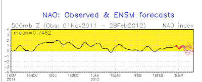
Of course; the strongest influence by far on our weather continues to be the NAO/AO oscillation which has been nearly consistently positive since last Autumn (check it out; Fig -1 below). This was the main reason the winter was so mild as explained in earlier blogs. Looking at the Winter 2012 preliminary statistics at Detroit all data includes leap day, 2/29.

Detroit
Ave High:  39.5                                                 Precipitation
Ave Low:  26.4                                                 7.70"/ +1.26
Wntr Ave: 33.0 /6th warmest/                       Snow thru 2/29th
 (warmest winter since 2001-02 @ 33.8)    25.8"/-8.3"

Flint
Ave High:  38.1                                                 Precipitation
Ave Low:  24.2                                                  5.85/ +0.82
Wntr Ave: 31.2 /5th warmest/                        Snow thru 2/29th
 (warmest winter since 2001-02 @ 31.7)     32.3"/-6.3"

Saginaw    
Ave High:  36.9                                                  Precipitation
Ave Low:  24.2                                                  5.85/ +0.82
Wntr Ave: 30.6 /3rd warmest/                        Snow thru 2/29th
(warmest winter since: 2001-02 @ 30.5      41.9"/+7.6
                                  1997-98 @ 30.9)
_______________________________________________________________________

                                                                                  Fig -1


With the NAO remaining positive throughout the winter, the dominant analogue winters were virtually useless. The last time a winter was so "contrary" to popular analogue opinion and Outlook was back in the Winter of 2001-02. Interestingly, the "popular call" that winter was also for below normal temperatures; instead it too turned out to one of the warmest winters /5th/ on record in Southeast Lower Michigan and much of the country. While this past winter was a La Nina winter, the Winter of 2001-02 was a Neutral Winter that subtly evolved toward a El Nino late winter (but ENSO's influence too, like this past winter was negligible). The trump card in any winter season on the temperature side and lesser extent snow of course; is the prevailing phase of the NAO/AO!
 
There were two coincidences between these two winters one straight forward and one; conjecture and controversial. It was suggested in some scientific papers written about the 2001-02 winter and the questionable strong solar flare influence on the planetary winds. As in the past winter, the NAO also remained strongly positive for much of the Winter of 2001-02 which certainly accounted for the largest mild impact on the winter then and now!  This near term peak in solar flare activity (relative to recent trends) during this past fall and winter; albeit weaker in strength, is just an intriguing parallel between the two winters and accompanying solar flare periods, and of course like 2001-02, research would have to be done.

Ironically; as I go to press the strongest solar flare episode since late 2004 had just been reported.

While on the subject of solar activity another very interesting article was written by Joe D'Aleo on the recent minimum solar activity, before the sun's latest burst into its 23rd cycle. I personally feel more research should be done on the correlation between sun spot activity and weather and climate patterns on earth.

From Wikipedia on this particular subject:

Solar Variation and Weather

There are some suggestions that there may also be regional climate impacts due to the solar activity. Measurements from NASA's Solar Radiation and Climate Experiment show that solar UV output is more variable than the total solar irradiance. Climate modelling suggests that low solar activity may result in, for example, colder winters in the US and southern Europe and warmer winters in Canada and northern Europe, with little change in globally-averaged temperature. More broadly, links have been suggested between solar cycles, global climate and events like El Nino. In other research, Daniel J. Hancock and Douglas N. Yarger found "statistically significant relationships between the double [~21 year] sunspot cycle and the 'January thaw' phenomenon along the East Coast and between the double sunspot cycle and 'drought' (June temperature and precipitation) in the Midwest."

Recent research at CERN's CLOUD facility examined links between cosmic rays and cloud condensation nuclei, demonstrating the effect of high-energy particulate radiation in nucleating aerosol particles which are precursors to cloud condensation nuclei. Dr. Jasper Kirby, a team leader at CLOUD, said, "At the moment, it [the experiment] actually says nothing about a possible cosmic-ray effect on clouds and climate, but it's a very important first step."

1983–1994 data from the International Satellite Cloud Climatology Project (ISCCP) showed that global low cloud formation was highly correlated with galactic cosmic ray (GCR) flux; subsequent to this period, the correlation breaks down.Changes of 3–4% in cloudiness and concurrent changes in cloud top temperatures have been correlated to the 11 and 22 year solar (sunspot) cycles, with increased GCR levels during "antiparallel" cycles. Global average cloud cover change has been found to be 1.5–2%. Several studies of GCR and cloud cover variations have found positive correlation at latitudes greater than 50° and negative correlation at lower latitudes. However, not all scientists accept this correlation as statistically significant, and some that do attribute it to other solar variability (e.g. UV or total irradiance variations) rather than directly to GCR changes. Difficulties in interpreting such correlations include the fact that many aspects of solar variability change at similar times, and some climate systems have delayed responses.

Spring 2012 Outlook

Temperatures:
Look for temperatures to average mainly above normal during the Spring of 2012. The strong NAO/AO+ pattern of the fall-winter continues to dominate as we move into spring-time.

Precipitation:
Rainfall during the spring and especially summer is more variable; occasionally areas of above, below or around normal can exist in the same season over a relatively small area. During the Spring of 2012; I look for precipitation to average normal to above normal across much of the region.

Severe Weather:
Since a strong jet stream is an important ingredient for severe weather, the position of the jet stream determines the regions more likely to have severe weather.

Contrasting El Niño and La Niña winters, the jet stream over the United States is considerably different. During El Niño the jet stream is oriented from west to east over the northern Gulf of Mexico and northern Florida. Thus this region is most susceptible to severe weather. During La Niña the jet stream extends from the central Rockies east - northeastward to the eastern Great Lakes. Thus severe weather is likely to be further north and west during La Niña than El Niño. As stated above; while La Nina conditions over the Pacific are disappearing, a La Nina-like scenario would bring at least average to even above average severe weather to the region.

Spring Analogues:
As mentioned, analogue data was virtually useless with the main driver of the winter the NAO+/AO+. However, in the analogues years where the patterns seemed the closest to our recent mild winter conditions and prevailing NAO+/AO+, the springtime temperatures and precipitation are shown below. In addition, included is the the springtime precipitation for all the previous winter analogues. The data maps show the warm weather continued to prevail from the Plains eastward across the country. Below normal temperatures were found out west. Overall; precipitation averaged normal to above east of the Mississippi in both sets of years of the analogue data.


Making weather fun while we all learn,
Bill Deedler -SEMI_WeatherHistorian