As many of the analogues and computer guidance mimicked one another; the summer thus far has had something for every one. Heat, storms, intermittent cool spells and just enough rain to keep the growing season going. In fact; if one had any complaints; a little less heat would be appreciated in many areas. Mentioning heat; due to the above normal temperatures the first half of summer; I'm raising the projected summer temperature average from formally near normal; to above. Though I'm expecting somewhat cooler weather in August (see forecast below); I still feel the final summer average temperature will be above normal. In addition; rainfall should still average around normal to above for the summer with sufficient "ridge riding" areas of showers and thunderstorms. However; it should be noted the best chance for a drier summer month in the analogues pointed to August. Looking at just the 30 day guidance mid July to mid August weather pattern still brings chances of rain through the remainder of July - but chances dropping off early to mid August.
Temps in June 2025


A Couple of Rounds of Rough Weather Have Also Entered the Picture This Summer
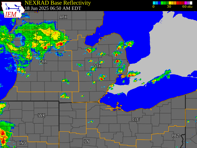
June 18th~ (from NWS)
Multiple rounds of thunderstorms impacted portions of Southeast Michigan on June 18, 2025. The first round consisted of sub-severe pop-up thunderstorms during the morning hours. These produced pockets of heavy downpours but otherwise brought some relief to areas that had seen relatively dry conditions in recent days. Nearly stationary storms dumped 3 to 5 inches of rain over a localized area in central Macomb County where flash flooding occurred early in the afternoon, closing roads and leading to several water rescues. A weak tornado /F0/ quickly developed as several outflow boundaries collided near Fraser in Macomb County. Then later in the evening; a line of storms prompted a Severe Thunderstorm Watch and several Severe Thunderstorm Warnings with isolated occurrences of wind damage across southern parts of the state.
Radar Loops
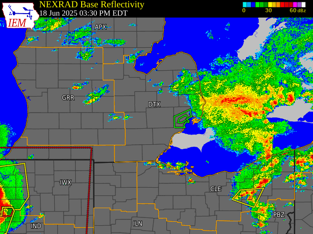
June 24th~ Severe Weather
A severe thunderstorm with a strong broad wind field pushed through the northwest and north suburbs during the afternoon of the 24th. Strong to severe thunderstorms with wind gusts varying from 40-50 mph to near 70 mph were reported. Severe thunderstorm warnings were issued for Oakland, Macomb and Northeast Wayne counties. Below is a radar velocity map with legend of the large section of the storm as is moved through that area 317pm EDT.

Outlook For August /CanSIPS 500 MB model and Analogues/
Ridging is projected to focus further west more from the Plains into the Rocky Mountains over the West. This would create a more of west-northwest flow over the Great Lakes. Already east/west movement of the ridging has been reflective of the active period into mid July with mainly above normal temperatures and several frontal systems as the ridging shifts east and west. As stated, extended modeling (see map below) aligns with several of our cooler August analogues (chart below that) as the upper winds show ridging dominating further west from the central US into the Rockies. With this suggesting more of a west-northwest flow; temperatures should average closer to normal in August rather than well above as in June & July thus far. June's temperature average of 72.2 was 2.3 above normal and thus far through July 20th, Detroit's temperature averaged 76.0 /+2.0.

Ironically, as the August computer upper wind guidance projection veers more northwest; the August analogue temperature pattern also supports quite a few below normal temperatures /6 years worth/ while there are 5 years with near normal temperatures. Therefore, out of the analogue total set of 14 years; 11 years contained normal to below normal temperatures.
Next: Late summer - early fall
Hemispherically ~ what's projected with the various climate patterns and our resultant weather expected for the Autumn.

Making weather fun while we ALL
learn,
Bill Deedler
- SEMI_WeatherHistorian