As Autumn 2023 officially arrived this recent Saturday, September 23rd at 250 AM EDT; lets look back at the late spring, summer and early climatological fall also known as the main growing season.
Summer 2023 Prelude and Opening
Summer of '23 started out lousy as far as the growing season with the dry weather beginning as far back as May. What had started as a wet late winter and early spring; dried notably in May (of course, when rain is needed for the new growing season). Less than an inch of rain fell /0.92/ at Detroit, nearly three inches /-2.88/ below normal. Flint received just 1.08" /-2.00/ of rain; while Saginaw started the growing season having just .80" of rain /-2.61/ in May.
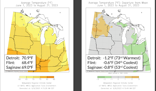
Temperatures averaged slightly on the cool side in May which actually carried over throughout the summer. The drier pattern continued into the first third of June when no measurable rain was recorded at Detroit, Flint nor Saginaw. This led to a difficult opening to summer when rain is most needed for the growing season. However; the "flood gates" opened the remainder of June right through the summer into mid September. A blatant change was seen in the frequency of sharply conflicting air masses leading to frontal activity with copious available moisture. So variable were the air masses; that dew points varied widely during the summer. Warm to rarely hot temperatures accompanied by extraordinary juicy dew points peaking from the mid 70s into the lower 80s (rare). While on the flip-side; outstandingly fresh, cooler Polar oriented air routinely surged back into the Great Lakes (especially Eastern Lakes) behind back-door cold fronts and sprawling high pressures over Southeast Canada. This succession of fresh air masses drove temperatures back down into the 60s and 70s as dew points cratered into the 40s and 50s; resulting in humidities dropping into the 20s and 30s. More in analogue temperature and upper winds projections in Summer Outlook review below.
Stormy Weather and Rainfall
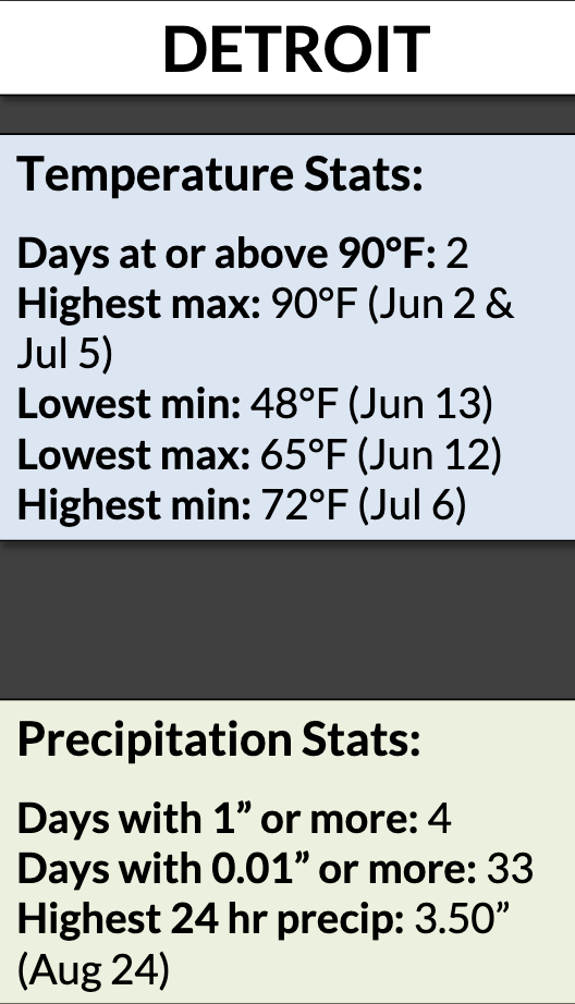
Storm activity became more frequent as back-door cold fronts lessened and strong instability charged-up with increasing humidity ahead of fronts more often from the south and west. The worst of the stormy weather came at the end of the summer in a two day period with thunderstorms with heavy flooding rains on 23rd and the ultimate climax of severe weather in the evening the 24th. Several spin-up tornadoes occurred along a powerful cold front which plowed into almost an unbelievable unstable air mass.
The Following are the excellent Notable Weather Write-ups for the Summer (and one Spring) 2023 from the NWSDTX. Click on headline and link will pop up.
- August 24, 2023 Evening Tornadoes
- August 24, 2023 Early Morning Flooding/Severe Weather
- August 11, 2023 Perry Tornado
- July 26, 2023 Severe Wind Event
- July 20, 2023 Severe Weather Event
- July 14, 2023 Lexington Tornado
- July 11, 2023 Severe Weather Event
- June 25, 2023 Severe Weather Event
- June 15, 2023 Detroit Beach Tornado
- April 1, 2023 Dundee Tornado
Stats for the Summer 2023
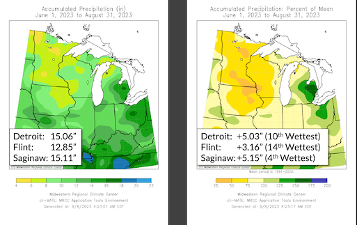
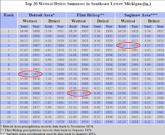
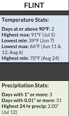
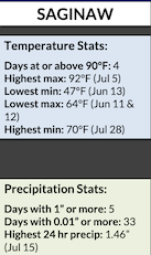
Rainfall locally here measured well above average over northwest Wayne county. For the summer; 17.06" fell and the growing season totaled approx 20.10" thus far. Detroit Metro /DTW/ above reported 15.06" /+5.03/; Flint measured 12.85" /+3.16"/ and Saginaw 15.11" /+5.15/ - all three making the top 20 wettest (above chart).
Summer Outlook Performance
Temperature Forecast:
Fluctuating Warm-Cool Temperatures Indicate Normal - Slightly Below Temperatures. Prevailing analogues indicate normal temperatures (within a degree of normal in Southeast Lower Michigan), while 4 summers averaged below normal (more than a degree below) and only 2 summers averaging above normal (more than a degree above normal.
Temperatures resulting from predicted upper air pattern worked out very well. The dominance of the ridging from Mid-West northward into Canada west into the Western US. This allowed a prevalent Upper low and accompanied cooler jet diving into southeast Canada/Eastern Great Lakes. This kept most of the hot weather to our west-southwest with very few 90s.
Temperatures on average came in at 0.8 below normal /-0.8/ departure across all of Southeast Michigan. The largest below normal departure was at Detroit /-1.2/ which makes perfect sense due to the rising normals most prevalent there, due to the heat island expanding westward at DTW.
Bill Deedler -SEMI_WeatherHistorian