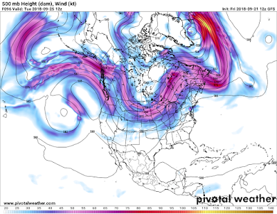
They say "a picture is worth a thousand words" and the following snaps state it well. Note the aggressive shift in the jet stream, the belt of winds at the 500MB level (18kt) and up pushing further south and east with time starting by mid week. Colder, polar air that is entrained in the systems will eventually make it down to the surface with time accompanied by intervals of warmer air, classic of the change of season.
Tue 9/25
Fri 9/28
As you can see in the maps, the northern jet becomes very active this upcoming few weeks; phasing with the Pacific jet at times and progressing east across the country.
Further out in "la la land" the GFS model continues the aggressive jet stream lock with a "full-lat" trough over North America. Of course; I must state that especially further out in time, of course these prognostics maps can be more questionable. It's been my experience that it's the trend or change of trend in the patterns that is most helpful. Many times the trend does develop but is slower to evolve and variances in the upper air pattern form. I'm sure variances in this pattern change will be projected in the next several runs.
Sat 9/29
Sun 9/30
Mon 9/30
Closer to the ground at 850MB /5kt/ we can see the colder air making its advance through the northern tier of the country. The trend shows this is the time more widespread frost/freezes (not scattered lighter frosts) MAY occur by early October, which is earlier than average in parts of Southeast Lower Michigan. A killing freeze generally doesn't occur across all of Southeast Michigan this early but needs to be watched. It will be outstanding even if the trend of the model predictions come to pass. Temperatures are projected to fall into the 30s over much of the region early October.
Mon 10/1
Wed 10/2

Making weather fun while we ALL learn,
Bill Deedler - SEMI_WeatherHistorian


