Epilogue;
Snowstorm Totals From the NWS DTX
Feb 26-27, 2013 Snow Totals
A strong low pressure system
originating near Texas tracked northeast into the Ohio Valley. This
storm induced blizzard, winter storm, and tornado headlines as it
tracked through the US. As the low lifted north, a mix of rain,
freezing rain, sleet, and snow commenced Tuesday afternoon. A
changeover to snow began near 4-7pm for most areas. A general 3-5"
swath of snow fell across most of Southeast Michigan. Text and graphic
summaries are available below. Snowfall totals through 10 am February
27th, 2013, are available in
graphic and text formats.

PUBLIC INFORMATION STATEMENT...STORM TOTALS
NATIONAL WEATHER SERVICE DETROIT/PONTIAC MI
1016 AM EST WED FEB 27 2013
STORM TOTAL SNOW REPORTS
LOCATION SNOWFALL DURATION
(INCHES) (HOURS) LAT LON
...BAY COUNTY...
AUBURN M 2.6 12 43.60N 84.08W
...GENESEE COUNTY...
BURTON M 2.2 14 43.00N 83.62W
FLINT M 2.8 14 43.02N 83.69W
LINDEN M 3.0 14 42.82N 83.78W
...HURON COUNTY...
FILION M 0.6 12 43.90N 83.00W
BAD AXE M 3.2 11 43.80N 83.00W
...LAPEER COUNTY...
LAPEER M 4.2 14 43.05N 83.32W
LUM M 5.1 15 43.10N 83.15W
NORTH BRANCH M 5.4 14 43.23N 83.19W
...LENAWEE COUNTY...
ADRIAN M 3.0 12 41.90N 84.04W
TIPTON M 6.0 14 42.02N 84.06W
...LIVINGSTON COUNTY...
HOWELL M 2.0 13 42.61N 83.94W
...MACOMB COUNTY...
STERLING HEIGHTS M 3.0 13 42.58N 83.03W
MOUNT CLEMENS M 5.5 8 42.60N 82.88W
...MONROE COUNTY...
MONROE M 0.8 M 41.92N 83.39W
DUNDEE M 3.7 14 41.96N 83.66W
...OAKLAND COUNTY...
HOLLY M 2.8 14 42.80N 83.62W
2 N NOVI M 4.0 12 42.50N 83.49W
BLOOMFIELD HILLS M 4.0 14 42.58N 83.25W
CLARKSTON M 4.0 14 42.74N 83.42W
SOUTHFIELD M 4.0 12 42.48N 83.26W
FARMINGTON HILLS M 4.3 14 42.49N 83.38W
WHITE LAKE M 4.5 14 42.65N 83.50W
...SAGINAW COUNTY...
5 S MERRILL M 4.0 13 43.34N 84.34W
FREELAND M 4.5 13 43.52N 84.12W
HEMLOCK M 6.5 14 43.42N 84.23W
...SANILAC COUNTY...
DECKERVILLE M 5.0 12 43.53N 82.74W
LEXINGTON M 5.0 13 43.27N 82.53W
SANDUSKY M 5.0 13 43.42N 82.83W
...SHIAWASSEE COUNTY...
CORUNNA M 3.0 12 42.98N 84.12W
OWOSSO M 3.7 14 43.00N 84.18W
...ST. CLAIR COUNTY...
YALE M 4.5 13 43.13N 82.80W
...TUSCOLA COUNTY...
FAIRGROVE M 2.0 12 43.52N 83.54W
VASSAR M 2.6 14 43.37N 83.58W
CARO M 3.0 12 43.49N 83.40W
...WASHTENAW COUNTY...
SALINE M 3.6 14 42.18N 83.78W
MANCHESTER M 4.0 14 42.15N 84.04W
5 SE ANN ARBOR M 5.0 13 42.22N 83.66W
CHELSEA M 5.0 14 42.31N 84.02W
1 W ANN ARBOR M 5.5 14 42.28N 83.75W
DEXTER M 6.8 14 42.33N 83.88W
1 S ANN ARBOR M 7.0 14 42.26N 83.73W
...WAYNE COUNTY...
GROSSE POINTE FARMS M 2.4 14 42.40N 82.89W
ROMULUS M 3.0 14 42.22N 83.37W
M = MEASURED
E = ESTIMATED
________________________________________________________________________________
Update 2/26/13...100 PM
Mixed precipitation will
advance across Southeast Lower Michigan during the afternoon quicker
than initially anticipated...therefore a longer period of
rain...snow...sleet and freezing rain will occur into at least early
evening. Because of more mixed precipitation; snowfall amounts will be
impacted, especially over extreme Southeast Lower Michigan. Latest
guidance /12z - 7AM/ continues to wrap in pockets of milder (above
freezing air) into the storm into the evening anyway. This was the risk noted in earlier forecasts below and thus, snowfalls have been adjusted lower.
Snowfalls
across extreme Southeast Lower Michigan from I-94 south to the Ohio
border will be impacted the most with generally 1" - 3" likely. The
remaining area of Southeast Lower Michigan; Detroit, Detroit's
northwest-northeast suburbs, Ann Arbor, Flint, Saginaw Valley and Port
Huron amounts will vary from 2" - 3" over the extreme southern regions
to 3" - 5" across the majority of the region into the northern areas. Best snowfalls will remain over the northeast counties including the Thumb where 4" - 6" is expected to accumulate. Stiff northeast winds will gradually shift to north at 15 to 25 mph with gusts around 30 mph into tonight before diminishing.
Update 2/25/13...
Snowfalls
Generally
I look for a 4" - 7" total of heavy wet snow over much of region from
this system through Wednesday - with much of that snow falling late
Tuesday into midday Wednesday. Eastern counties, especially downwind of
Lake Huron may see highest with isolated 8" or so possible. I will
update if the system information changes going into the event.
Discussion
Overall
very little has changed on our expected winter storm the past few days
as most models continue to prog the storm in the track first outlined in
the original blog 2/23. In fact; the major models are in remarkable
agreement as to the general track of the low center with a subtle shift
southward of both the 500H MB and surface low in the last 12-24 runs.
The
European continues this lead (I originally chose in the initial blog
below) with now both the GFS and the European pretty well in step. Of
course; the devil is in the details...and in this case the problems lie
in precipitation amounts and how much "warm air" gets entrained into the
lower levels of the atmosphere. While this system somewhat resembles
our Dec 26th storm it is much further north and thus; milder but at the
same time the dynamics of the system are more impressive overhead as is
its moisture feed from initially the Gulf and subsequently Atlantic.
The
system has well developed features aloft including; a compact negative
tilt structure that consolidates into a "bowling ball" shape that
"hooks" for the Ohio pocket as she heads northeast. Meanwhile; the
surface system along with the 700MB low follow along in good measure
right into Southeast Lower Michigan and Northwest Ohio. And old rule of
thumb with the 700 MB; to the left of center, generally the best snow
can be expected in a mature system. And, while our storm is projected to
weaken with time as she treks toward the Eastern Lakes; she still
maintains a moderately impressive storm structure in our neck of the
woods from Tuesday evening into the first half of Wednesday. In
addition; right about the same time Atlantic moisture should rev-up into
the system in conveyer-belt like fashion later in the aforementioned
period. Good vertical velocity and energy aloft should make for a good
dump of
precipitation later Tuesday into Wednesday morning...though as with most
systems this season, heaviest precipitation will be south and east of
us...a noted trend this winter. Snowfall rates in spite of temperatures
initially falling just into lower to mid 30s after precipitation onset
may approach an inch an hour in the late afternoon to evening time frame
in heavy wet snow. This timing may change if the precipitation advance
slows a bit. A mixed bag of precipitation is also still in the cards,
especially over extreme Southeast Lower Michigan and mainly in the
initial stages of the event.
(see explanation below). A stiff and
gusty northeast wind at 15 to 25 mph with gusts to around 30 mph will
accompany the precipitation into early Wednesday.
500H with vorticity est maxima's (X)
Now;
the above scenario is all nice and good but she (500 MB Jet) also gets
the boot from energy diving into her back/west side which why may help
with troughing westward; will also help move things along to the east.
Therefore; the center of the best action doesn't stick around quite as
long as I would like to see for the BIG accumulations.
Besides
less precipitation than earlier expected; another problem is the system
still nicks Southeast Lower Michigan enough so that pockets or envelops
of "milder, above freezing" ice-crystal melting air will also mess with
our snowstorm (it always seems these things are never easy around
here). This continues to bring the risk of mixed rain, snow and sleet
mainly at the onset. While this churning of milder air is seen in
pockets aloft and at the surface early in the event, this should
ultimately be offset by dynamic cooling aloft especially when
considering precipitation intensity - along with the drier, cooler air
feeding the system from the northeast. However; being so marginal aloft
in the temperature departure lets the door open for the risk of some
mixed precipitation well into early Wednesday.
Need a refresher on what determines snow, sleet or freezing rain? Or not sure what each type is?
Check out a great tutorial @ http://www.nssl.noaa.gov/education/svrwx101/winter/types/
Making weather fun while we all learn,
Bill Deedler -SEMI_WeatherHistorian
_________________________________________________________________________________
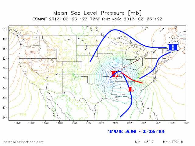
Original Blog 2/23...
As
mentioned in my last blog, our models were intimating another storm for
this coming week and snow lovers should not give up hope. Latest
forecasts of all the models continue those earlier projections of
bringing a large storm and low pressure area toward the Great Lakes this
upcoming Tuesday into Wednesday...with lingering affects possibly
lasting into Friday.
Meteorological data for this storm
is now (Sat AM 2/23) being sampled over the far Western states and
thus; the model runs are starting to get a better idea of the atmosphere
projected to develop this storm. All data thus far; promotes the
development of a Texas Hooker type of low pressure system Sunday into
Monday that slides into the Boot-heel of Missouri by Tuesday morning.
The center of the storm is then expected to slide northeast across the
western Ohio Valley through Tuesday night and be over Southeast Lower
Michigan by Wednesday morning. This system appears to have the
capability of bringing both Gulf of Mexico and Atlantic moisture to
Southeast Lower Michigan.

While
preliminary data supports a more significant storm than this past
Friday's weakening storm, questions still arise as to the nature of the
precipitation. At this time; the best estimates from the early data
points to a mixed rain and snow scenario to arrive Tuesday afternoon
before changing to all snow sometime Tuesday evening lasting into
Wednesday. Heavy amounts of snow are possible with this system
especially if the majority of the precipitation received is, in fact
snow. Since this time period is still 3 - 4 days out and as you know in
this business; things can change - but look for updates on the progress
of the system into Tuesday.
Making weather fun while we all learn,
Bill Deedler -SEMI_WeatherHistorian


+psdef+.gif)


