Let cut right to the chase; meteorological winter made a liar out of me since I predicted normal to below normal temperatures in Southeast Lower Michigan for the Winter of 2012-13. Early on; most guidance suggested it and analogues backed it up, so what happened? Nothing...other than winter come late to the party and screwed up my temperature forecast ;-). As mentioned many times in my outlooks and discussions, timing is one of the biggest problems in forecasts... particularly monthly and seasonal. Many of the analogues had the pattern pegged (above normal temperatures early winter to below mid & late) but none were as mild as the Winter of 2012-13.
Averaged out; temperatures for the meteorological winter (December through February) came in above normal across Southeast Lower Michigan (scroll down to data from the NWS). In fact, December into mid January averaged well above. However, as the second half of the meteorological winter (mid January - February) evolved; the pattern I was looking for to dominate through much of the winter did in fact, materialize. And, with the exception of the "few day heat wave" at the close of the January; mid January on into early March really "began" winter with normal to below normal temperatures (dark blue temperature trace). In February, not only did temperatures average normal to below across Southeast Lower Michigan but much of the region got pestered (or treated depending on one's view) with frequent snows...making it also, a snowy month. It's really not so unusual for winter to not get a foothold on the region until around Christmas but mid January, mom nature has some explaining.
It is one thing to discuss the winter temperatures, another to actually visualize it...therefore, a picture is worth a thousand words...or at least a paragraph or two. ;-)

It's easy to see how temperatures (above the mean yellow normal line) for much of January averaged above normal. A change of the trend (temperatures below the mean yellow normal line) began when the first real cold snap of the winter pushed temperatures down to near zero during the 21st-23rd (5,-1,5 @ DTW and colder elsewhere). Quickly after; there was one more warm surge on the 29-30th (57, 62 @ DTW) only to come crashing back down to the single figures Feb 1st, 3rd (9, 5 @ DTW). Many of the meteorological inclined can visualize the amplified and progressive upper air pattern creating the temperature fluctuations at that time.
Ah well, if January through March had been our meteorological winter; maybe a hit instead of a miss? Many of my comrades share with me the difficulty in predicting this past winter season three months out and sometimes, the weather for just three days. It seems all across the country mom nature kept weatherman on their toes (and sometimes, biting their nails ;-). But that's the past and on to the future....after a few statistics.
The following are the temperature and precipitation statistics for the three climate locations in Southeast Lower Michigan. Snowfall is not included since theoretically, it's not over for the winter.
Winter 2012-13 Statistics *
                AVERAGE TEMPERATURE

              ACTUAL   NORMAL  DEPARTURE     RANKING
DETROIT AREA   30.4     27.9     +2.5      17TH WARMEST
FLINT AREA     28.5     24.9     +3.6      10TH WARMEST
SAGINAW        28.5     24.7     +3.8      10TH WARMEST
                   AVERAGE HIGH TEMPERATURE

              ACTUAL   NORMAL  DEPARTURE     RANKING
DETROIT AREA   37.5     34.4     +3.1    T-16TH WARMEST
FLINT AREA     36.2     32.2     +4.0     T-8TH WARMEST
SAGINAW        35.2     31.4     +3.8          N/A


                   AVERAGE LOW TEMPERATURE

              ACTUAL   NORMAL  DEPARTURE     RANKING
DETROIT AREA   24.0     21.4     +2.6      21ST WARMEST
FLINT AREA     20.9     17.7     +3.2      14TH WARMEST
SAGINAW        21.7     18.0     +3.7          N/A
                       PRECIPITATION

              ACTUAL   NORMAL  DEPARTURE     RANKING
DETROIT AREA   8.92"    6.44"   +2.48"     11TH WETTEST
FLINT AREA     8.04"    5.03"   +3.01"      6TH WETTEST
SAGINAW        7.14"    5.24"   +1.90"     16TH WETTEST
* Data supplied from the National Weather Service White Lk. /DTX/
Spring 2013 Outlook
Since winter got a late start, does that automatically mean spring will too? Not necessarily, but in this case I think there will be likely some truth to that statement. However, that doesn't automatically mean that temperatures for spring on the whole, will average below normal.
ENSO remains in a neutral pattern across the Pacific therefore, it will have little if any effect on our spring weather across Southeast Lower Michigan. The main players this spring will be the phase dominance of the NAO/AO, the PDO and PNA relating to the jet stream positioning and placements of long wave troughs and ridges.
ENSO remains in a neutral pattern across the Pacific therefore, it will have little if any effect on our spring weather across Southeast Lower Michigan. The main players this spring will be the phase dominance of the NAO/AO, the PDO and PNA relating to the jet stream positioning and placements of long wave troughs and ridges.
Spring especially has that "curse" of being extremely changeable therefore, trends and pattern formations are even more fickle than winter. Being so changeable, projections for the season can be quite a challenge. I will discuss what prevailing temperatures and precipitation I expect along with reasoning. In future blogs, as in the past, I also plan to discuss notable changes and trends that will affect our spring weather .
Temperatures
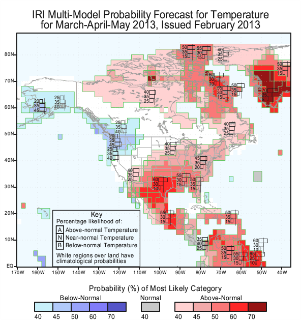
I look for temperatures to average around normal to below during early spring as our late winter hangs over into much of March and possibly, even parts of April. That is not to say we won't have beautiful, warm spring days such as like Sunday (3/10) but overall temperatures early spring should still average around normal to below. For the latter half or so of spring on average, temperatures should have preference for above normal readings. All in all, I look for temperatures to average within 2 degrees of normal for the spring season.
Reasoning for the cooler than average early spring;
1 - Arctic Oscillation /AO/ recent preference for neutral to negative oscillation phase
Since mid winter our cyclical northern friend/foe has been oscillating between around average to below average and as one can see here, still shows a preference for that in the coming weeks. The second plot is an experimental projection of the Arctic Oscillation. Be advised; both these models change frequently and it is the prevailing trend we are concerned with when examining them.
Note both plots show an extreme negative Arctic Oscillation /as low as -4/ in the short term mid month. It will be interesting to see if this bears out.


2 -The more inclusive, North Atlantic Oscillation /NAO/ also shows a decided preference for a neutral to negatively phased oscillation.

3- The residual cold air stored over the Canadian/Polar regions which is aided by deep snow cover and relatively low sun angle early spring, acting like a freezer.

*4 - Great Lakes Water Temperatures /Added - 3/13/13 /
I wanted to also share the Great Lake's water and ice content as of 3/13/13 and adding to list of reasoning's for cool early spring. I was able to get the latest data from a the wonderful site /GLSEA/ which is part of the Great Lakes Environmental Research Lab /GLERL/. As you can see, several of the recent winter's water temperatures are on these charts. What I found interesting is the recent decrease in water temperatures so late this season, so much so, that now the water temperatures are really close to the colder winters we had in the recent past. In addition; note the big change (drop) from earlier this season for Lake's Michigan, Huron and Erie.


I wanted to also share the Great Lake's water and ice content as of 3/13/13 and adding to list of reasoning's for cool early spring. I was able to get the latest data from a the wonderful site /GLSEA/ which is part of the Great Lakes Environmental Research Lab /GLERL/. As you can see, several of the recent winter's water temperatures are on these charts. What I found interesting is the recent decrease in water temperatures so late this season, so much so, that now the water temperatures are really close to the colder winters we had in the recent past. In addition; note the big change (drop) from earlier this season for Lake's Michigan, Huron and Erie.

-Lake Michigan is colder than last year and 2010 and on par with 2011.

-Lake Huron is also colder than last year and 2010; and now very close to the remaining years.


Some Model Temperature Projections for Spring:
(As
you can see, just these three have somewhat differing opinions and
sometimes Southeast Lower Michigan seems to be caught in the middle)
+psdef+.gif)
Precipitation/Severe Weather
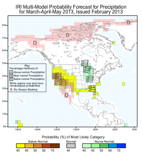
Rainfall should average around normal to above across the region as confrontation zones set up along the fairly active spring pattern induced by a fluctuating NAO and semi-permanent ridge over the southeast part of the country. The interaction will induce normal to above normal rainfall. Generally, in this sort of pattern; severe weather would be expected to be active. This will greatly depend on how dominant a particular phase of the NAO is this spring along with attending jet cores and available instability per event. A strongly negative /NAO-/ would tend to hold the more active severe weather to our south, whereas a more variable NAO oscillation would tend to allow more warmth, instability and stormy periods. I'll keep a lookout for possible upcoming active severe weather episodes.
Model projections for precipitation

Making weather fun while we all learn,
Bill Deedler -SEMI_WeatherHistorian
Hello There. I found your blog using msn. This is a very well written article. I will make sure to bookmark it and come back to read more of your useful info. Thanks for the post. I'll certainly comeback.
ReplyDeleteThanks for the compliment; I aim to please ;-)
ReplyDelete