Feb 22, 2016

This Week's Projected Snowstorm Lands on the Anniversary of the Snowstorm of '65 - February 25th, 1965 - A Storm That Started My Facination With Snowstorms

As mentioned yesterday, tomorrow we'll update the current expected major storm with the latest 12z guidance (Feb 23rd, 2016 -7AM EST) and adjust expected storm affects on the region by mid afternoon.

Below; we'll compare our present day storm with the storm that started it all for me as far as a fascination with snowstorms and thus, increased my desire to study weather. It ironically, occurred on the same date as our expected storm this week - The anniversary of Snowstorm of February 24-25th 1965! Just passing it's 50th anniversary last year, I remember the day well.

The best part, besides obviously the snowstorm ,was being off two days from school. In fact; those two days, February 25-26th 1965 were the only two days back in the old days (well before kids started to get off of school for anything weather related) that I ever was let off of school in grade or high school. I went to a Catholic grade school in northwest Detroit /St. Monica/ and high school /Bishop Borgess/ therefore; getting let out of school because of a snowstorm was rarely heard of anyway.

Anyway; on the morning of the 25th, which my memory recollected was a Thursday (and checking back on my computer verifies this) we were awaken to a heavy snow cover along with drifts I had never seen in the Detroit metro area growing up my 10 years previously. Snowfalls varied across the metro Detroit area but most were with a few inches of a foot. Officially in the far northwest part of Detroit, I measured a foot in several places around the house. Besides the heavy snow cover were the moderately strong, gusty winds which built drifts in the city lots/yards to up to 2 1/2-3 feet in places from my memory.

Let's take a look at new items from that memorable day for many...


SNOWSTORM Feb 24-25TH 1965

There are close similarities in the expected modeled storm this week, 51 years later and the actual Snowstorm of February 24-25, 1965.  Besides the obvious dates; ironically the Storm of '65 in its infancy was also a Gulf Low that developed in the same region as the models are predicting this weeks storm development on Wednesday, the 24th. The  storm development is expected down over the Louisiana/Gulf Region. The upper air appears very similar as does the surface low development and movement. One major difference with this week's weather is the milder temperatures expected ahead of/and during the storm which could obviously cut down on snowfall amounts. This especially will be noted where rain or rain mixed with snow falls

From the Toledo Blade, which gives a fairly thorough synopsis of the Feb 24-25th, 1965 storm...

"This could be called the "Midwest/Ohio Valley Snowstorm of 1965" 7.8" at Toledo, 11" at Detroit, 12.9" at Flint, 9" at Jackson MI, 10.3 " at Lansing, 17.9" at Saginaw, 7.5" at Grand Rapids, 12.7" at South Bend, 7.5" at Fort Wayne, 12.5" at Indianapolis, 10" at Chicago, 7.6" at Peru IN, 9.8" at Lafayette, 8.4" at Evansville, 6" Bowling Green KY, 3" Cincinnati, 7" Paducah."

"The surface low tracked from Louisiana to Cincinnati to north of Pittsburgh to north of Montreal. The rain-snow line was near a Toledo to Indianapolis line. It was a strongly deepening low from around 1002mb to 983mb in 24 hours, to 976mb in 30 hours.

It was 12 degrees and windy at Toledo after the storm ended. It is interesting to note this situation was along with a strong Greenland block but the upper level flow off the East Coast did not allow a coastal low to develop. This was a definite problem for transportation in Toledo, according to the Toledo Blade. It was also the largest single-storm total snowstorm at Toledo in the previous 14 years, according to the Toledo Blade."

500 MB Heights 


Surface


Detroit after the '65 Storm


Making weather fun while we all learn,
Bill Deedler -SEMI_WeatherHistorian


_____________________________________________________________________________
Previous blog 2/22/16

Major Late Winter Storm Likely to Impact Southeast Lower Michigan With Strong Winds and Heavy Snow!

After several days on various tracks of the possible impending storm, better sampling of the atmosphere is indicating very strong dynamic system with copious moisture will affect the region. A more definitive track is beginning to emerge even though this system is still a good few days away, it appears all models have a better handle on the outcome now.

Still; the exact track of the storm/low will have a major impact of snowfalls across Southeast Lower Michigan and Lower Michigan, as a whole. Along with the crucial track of the low determining snowfalls will be the existing relatively mild temperatures ahead and during the early stages of the storm on Wednesday when rain, mixed rain and snow is expected. All precipitation is expected to change over to all snow by Wednesday night into Thursday morning.

At this early juncture; snowfalls of 3 - 5" are likely across the mildest areas of Southeast Michigan over the Southeast corner Lower Michigan. Areas away from the Southeast corner; which includes much of the Metro Detroit Area west into Ann Arbor, Brighton, Howell, Flint and areas west and north where general snowfalls of 5"- 9" (highest amounts will be further away from the Southeast Lower Michigan corner where isolated higher snow amounts are possible). Besides of snow of course, will be the very strong northeast winds of 20 - 30 mph with gusts near 40 will cause problems with power and tree limbs along with the heavy snow.

This storm has more of a Gulf Low characteristic which generally contain the best moisture access along with a very strong southern jet streak in the upper atmosphere; classic of the deeper, more intense low pressure. It has been awhile since a true Gulf Low has affected the Lower Great Lakes and in fact, much of the country as most storms on the East Coast this winter have been Coastal Storm development with impulses originating from the West or Northwest. We saw numerous cousins of the Gulf Low over the Texas/Oklahoma/Arkansas region during the severe winter of 2013-14 and late last winter.


All indication are the storm will take shape over Southeast Texas/Louisianan/Gulf of Mexico as an intense subtropical jet streak containing impressive winds of 120-130 knots at the higher levels of the atmosphere /250-300 MB, or 33Kft-35Kft/ and strong horizontal and vertical velocities. It's certainly without question; the most impressive low pressure/storm center projected to affect the region in this benign winter season, anyway!

Next will take a look at specific upper winds and storm tracks of the 12Z/022316 models along with and a little Weather Historian history.  Look for updates during the next few days on this impending storm!

Making weather fun while we all learn,
Bill Deedler -SEMI_WeatherHistorian

Major Late Winter Storm Likely to Impact Southeast Lower Michigan With Strong Winds and Heavy Snow!

After several days on various tracks of the possible impending storm, better sampling of the atmosphere is indicating very strong dynamic system with copious moisture will affect the region. A more definitive track is beginning to emerge even though this system is still a good few days away, it appears all models have a better handle on the outcome now.

Still; the exact track of the storm/low will have a major impact of snowfalls across Southeast Lower Michigan and Lower Michigan, as a whole. Along with the crucial track of the low determining snowfalls will be the existing relatively mild temperatures ahead and during the early stages of the storm on Wednesday when rain, mixed rain and snow is expected. All precipitation is expected to change over to all snow by Wednesday night into Thursday morning.

At this early juncture; snowfalls of 3 - 5" are likely across the mildest areas of Southeast Michigan over the Southeast corner Lower Michigan. Areas away from the Southeast corner; which includes much of the Metro Detroit Area west into Ann Arbor, Brighton, Howell, Flint and areas west and north where general snowfalls of 5"- 9" (highest amounts will be further away from the Southeast Lower Michigan corner where isolated higher snow amounts are possible). Besides of snow of course, will be the very strong northeast winds of 20 - 30 mph with gusts near 40 will cause problems with power and tree limbs along with the heavy snow.

This storm has more of a Gulf Low characteristic which generally contain the best moisture access along with a very strong southern jet streak in the upper atmosphere; classic of the deeper, more intense low pressure. It has been awhile since a true Gulf Low has affected the Lower Great Lakes and in fact, much of the country as most storms on the East Coast this winter have been Coastal Storm development with impulses originating from the West or Northwest. We saw numerous cousins of the Gulf Low over the Texas/Oklahoma/Arkansas region during the severe winter of 2013-14 and late last winter.


All indication are the storm will take shape over Southeast Texas/Louisianan/Gulf of Mexico as an intense subtropical jet streak containing impressive winds of 120-130 knots at the higher levels of the atmosphere /250-300 MB, or 33Kft-35Kft/ and strong horizontal and vertical velocities. It's certainly without question; the most impressive low pressure/storm center projected to affect the region in this benign winter season, anyway!

Next will take a look at specific upper winds and storm tracks of the 12Z/022316 models along with and a little Weather Historian history.  Look for updates during the next few days on this impending storm!

Making weather fun while we all learn,
Bill Deedler -SEMI_WeatherHistorian


Feb 8, 2016

Cuddle Alert! Coldest Air of the Season Likely This Valentine's Weekend! And, What About Longer Term into March?

The more mixed pattern forecast and discussed recently has come to fruition the past month or so with a "sometimes mild, sometimes cold" pattern pattern taking hold. The biased however, continues to be on the mild side as El Nino continues to greatly influence our winter. However; the second player discussed for the winter, the Polar Vortex has been intermittently sticking its cold beak into our weather regime since January and thus, has been tempering somewhat our as an extraordinary mild winter! This resulted in January actually averaging just slightly above normal (as compared to December's double digit above normal departures) with colder air masses making an appearance. Actually; this month's pattern looks to be very similar to January's through mid month with a very mild week opening the month; only to be replaced by a cold one by mid month - and this is about to commence again.


A deepening low pressure system in formation over the Eastern Great Lakes into mid week will begin to draw down colder, Arctic air into the region by mid week with the coldest of the air arriving this Valentine's Weekend. Temperatures this weekend are anticipated to plummet from around the 50 degrees we felt this past weekend /Sunday/ to morning lows of single digits; above and below zero by Valentine's morning, this upcoming Sunday. Indeed, this would be the coldest air of this mild winter's run thus far. The colder air will be accompanied by light snow and snowshowers as moisture is fed into the system from the east and Great Lakes. The cold, cyclonic flow will aid in pulling down the much colder air that is in place over eastern Canada. The best snowfall amounts will naturally be downwind of Lakes Superior, Michigan and Huron where several inches could accumulate. In and around Southeast Lower Michigan away from Lake Huron and the Thumb Region; I'd look for generally one to three inches depending location through mid week. This expected snow cover will have more of an impact on overnight lows come this weekend, with the coldest mornings occurring in conjunction with snow cover, clearing skies and lighter winds.

Note the low temperatures projected for the coming weekend; granted these could change some but our past cold weather in mid January could see some competition this weekend. After; look for milder weather to again return to the region.


Rest of February into March 

Of interest to meteorological buffs; a very strong stratospheric warming has taken place over the Arctic as unseasonably warm air surged north into the highest of altitudes of the stratosphere. This pattern is generally associated with a dislodgement of the Polar Vortex normally over or close to that region. Latest indications are the Polar Vortex in in the process of splitting (as the GFS has picked up on) with one heading toward southeast Canada while the other heads over to Europe or further east.

"Major Sudden Stratospheric Warming"

These occurs when the westerly winds at 60N and 10hPa (geopotential height) reverse, i.e. become easterly. A complete disruption of the polar vortex is observed and the vortex will either be split into daughter vortices, or displaced from its normal location over the pole.

Longer Term
 
For a longer term through the rest of February and into March; note the following discussion by Atmosphere and Environmental Research /AER/.

AER scientists provide researchers and enthusiasts real-time insights on one of North America’s and Europe’s leading drivers for extreme and persistent temperature patterns. Author Judah Cohen, Ph.D., works at Atmospheric and Environmental Research (AER), a division of Verisk Analytics.

"Longer term we continue to expect that variability in the polar vortex (PV) to strongly influence Northern Hemisphere (NH) weather patterns.  Our confidence continues that a troposphere-stratosphere-troposphere coupling event (T-S-T) is underway (Cohen et al. J. Clim., 20, 5335, 2007), which is resulting in a sudden stratospheric warming (SSW) and is reversing the AO from positive to negative in the stratosphere.   The T-S-T should culminate with the negative phase of the AO favored in the troposphere from after the SSW peak through the end of winter.

General temperature trends across the NH should mirror trends in the AO.  As we have discussed many times previously, while the vertical energy transfer is active, the positive phase of the AO is favored in the troposphere.  The atmospheric energy transfer is now predicted by the weather models to be active through mid-February and even to achieve record values next week.  The record strong energy transfer is also predicted to bring record warm temperatures to the polar stratosphere next week making for an impressive SSW.  This SSW has been evolving for an unusually long time but is likely to peak with the record warm polar stratospheric temperatures next week.  The strengthening SSW should force a negative AO in the stratosphere. 

Our research and that of other scientists shows that the negative phase of the AO in the troposphere is favored, with a ten to fourteen-day delay, for the following four to six weeks after a SSW and a negative stratospheric AO. The evolution of the SSW or polar vortex weakening is likely to modulate which regions are favored for colder temperatures across the NH continents for the remainder of winter. The models are predicting for the PV to slide from its current position over northern Eurasia into the North Atlantic and then stretch out towards eastern North America. As the PV pinballs towards the North Atlantic, the models also predict geopotential heights to strongly build across the North Pacific side of the Arctic in the stratosphere.  This should result in a tropospheric reflection of strong positive geopotential heights across the North Pacific of the Arctic.  Strong geopotential height rises across part or all of the Arctic basin favors lower geopotential heights across Eastern Siberia, eastern North America and Northern Europe.  Lowering geopotential heights in eastern North America and East Asia coupled with ridging to the west will promote a northerly flow of cold air for those regions".


This forecasted pattern fits very well with the Winter Outlook where analogues indicated colder, but still variable temperature conditions likely to dominate the remainder of the cold season through March. The key here is how El Nino plays into this Polar pattern. Will it continue to be strong enough to influence the Pacific jet and allow mild, Pacific air to surge well east across the country; at least at intervals? While I believe the Polar Vortex has now become a viable contender to the El Nino influenced Pacific jet; both should remain in contention as spring approaches. That being said; this battle (as first mentioned back last fall in the Outlook) could very well intensify into a more stormy pattern not seen this winter in our neck of the woods. Again; WHERE these atmospheric battles take off is largely dependent on these two dominant patterns and if, when and where phasing takes place. It has been our observance this winter that notable winter storms have been basically all around the Lower Great Lakes - west, south and east - therefore it will be extremely interesting to see if that established pattern hangs tough the rest of the cold season or breaks down.


Making weather fun while we all learn,
Bill Deedler -SEMI_WeatherHistorian


Jan 29, 2016

"A GREAT STORM IS UPON MICHIGAN" THE GREAT BLIZZARD OF 1978!

"A GREAT STORM IS UPON MICHIGAN"
THE GREAT BLIZZARD OF 1978!

Written by: William R. Deedler, Weather Historian - Southeast Lower MI

As with the huge snowstorm of December 1974 another even more powerful (in terms of intensity/extent) storm is of strong interest to all meteorologists who have studied winter storms in the Great Lakes. This storm is also of interest and remembrance to many longtime residents of the Great Lakes, the Upper Ohio Valley and Ontario, Canada who had to deal with winter's full fury late in January of 1978. In addition, the storm certainly casts many memories for those of us (author included) who were on duty and worked during the storm...while being in awe of the development and subsequent immense strength of this great monster. With the 38th anniversary of this Great Blizzard at hand, it is worth taking a step back in time to re-live this monumental example of nature's fury.

While there are several contenders for the worst blizzard ever to hit the Great Lakes in relatively modern times (since 1870 when records began in Detroit), the immense and intense Blizzard of January 26-27th 1978 must rank at or near the top along with the Great White Hurricane of 1913 with its similar track and powerfulness.

The incredible Blizzard of January 26-27th, 1978 evolved out of a winter that was infamous for cold and storms. The Winter of 1977-78 thus far had been one the coldest, since records began, in many areas from the Rockies eastward to the Appalachians. Mammoth blizzards occurred late in January and early February from the Midwest to the East Coast as strong Arctic plunges dove south into the country and met up with the warmer winds from the deep south. The winter of 1977-78 was similar to its predecessor (1976-77) in terms of cold. The main difference between the two winters, however, came in February. In 1977, temperatures moderated rapidly during February, while in 1978, the cold actually worsened - with several locations reporting their coldest recorded February to date. The Winter of 1977-78 is written down in the record books as Detroit's seventh coldest winter, Flint's fifth coldest and Saginaw's sixth. West of the Rockies, it was a different story as a dominant upper ridge of high pressure provided a relatively mild winter, with some stations even reporting one of their warmest winters on record.


The Great Storm


Since there were some forecasted variances of the intensity and track of the storm, and considering the primitive model of the day (LFM - Limited Fine Mesh), forecasters did an admirable job in forecasting one of the most severe winter storms ever to hit the Great Lakes Region.

A Winter Storm Watch was posted as early as Tuesday night, the 24th, for the southern half of the Lower Peninsula for Wednesday Night into Thursday. Gale Warnings for the Great Lakes were hoisted the following Wednesday morning, along with the Watch. A weaker system had moved through the region earlier during the day on Tuesday and already dropped some snow on the region (a Winter Storm Watch had been issued for this system as well, earlier on Monday, the 23rd). After Tuesday's snow, the headline on the Special Weather Statement that was issued by the NWS Tuesday evening read as follows: "Another Winter Storm Threatens Lower Michigan" and thus, a second Winter Storm Watch was officially posted.

Meanwhile, the ingredients of what would later prove to be a truly fascinating yet vicious winter storm were coming together from different parts of the country. As with the "White Hurricane of 1913," the massive storm actually began as two smaller but distinct storms. A strong low pressure with an attending arctic air mass was entering the Northern Plains by way of Northern Minnesota on Tuesday evening (24th). At the same time, another developing low pressure system was taking shape over the eastern Texas/Louisiana area.

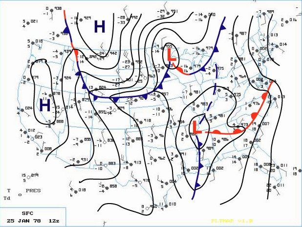
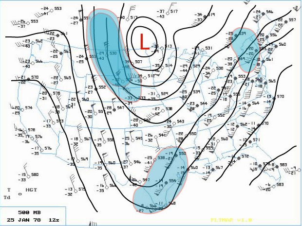
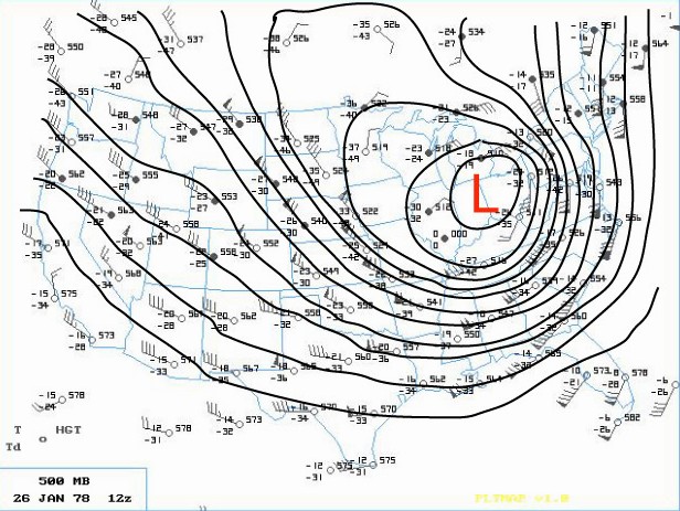
The phasing of two distinct jet streams aloft proved to be the key as to the subsequent strength and massive extent of the storm. A very strong and energetic Arctic impulse surged almost due south and plowed the Arctic front through the Northern Plains late on the 24th. At the same time, another very strong upper wind impulse surged south through southern Arizona. These two jet streaks made up the larger North American jet stream as a huge upper ridge of high pressure along the West Coast of the U.S. diverted the powerful Pacific Jet north into Northern Canada. This northern jet (containing a wind max of 110 knots) then dove due south, like on a giant roller coaster, across the western U.S. as the second, subtropical jet (with an even stronger wind max of 130 knots) surged across southwestern states. On Wednesday (25th), a deepening area of low pressure made its way east across the Gulf States into Georgia by evening (surface | 500mb). Meanwhile, across the north, the Arctic front barreled east across the Upper Midwest into the Western Lakes by Wednesday evening.

Earlier that Wednesday morning, the Winter Storm Watch for Southeast Lower Michigan was changed to a Heavy Snow Warning, while a Travelers Advisory was issued for Western and Northern Lower Peninsula. Later, at the issuance of the evening forecast, the entire Lower Peninsula was upgraded to a Heavy Snow Warning. Meanwhile, a rapid deepening of the surface low over the southeast portion of the country also commenced on Wednesday evening. As the low intensified over Alabama and Georgia, Atlanta registered its lowest barometric pressure ever late on the 25th. At the same time, further north in Michigan, snow was falling over much of the Lower Peninsula. In and around the Ann Arbor and Metro Detroit, the snow mixed with or changed to light rain Wednesday night as slightly warmer air surged northwest into that area ahead of the deepening storm.

While the storm was organizing in the lower levels of the atmosphere over Georgia, the Subtropical and Arctic jet aloft began to merge and phase over the Southeast part of the country. This merging of jet streaks contained a wind max of 150 knots which helped induce a rapid intensification of the Georgia Low as it surged northward into West Virginia early on the 26th. Record low barometric pressures were set all along its path as an ominous track (trough) began to materialize toward the Eastern Great Lakes.

Bands of heavier snow spread north into much of Southern Lower Michigan during the very early morning hours of the 26th. Rain continued to fall, however, over the extreme southeast corner of Lower Michigan. At 1 AM EST, rain was observed at Detroit Metro Airport with the temperature comfortably above freezing at 36 degrees. Further north at Flint, however, sleet and freezing rain were falling as the temperature hovered around freezing. Air pressure tendencies were noted as falling rapidly /PRESFR/ and continued that way for several hours (in fact, several stations in this storms path had to re-adjust their barographs for station pressures traces that were BELOW initial chart scale).

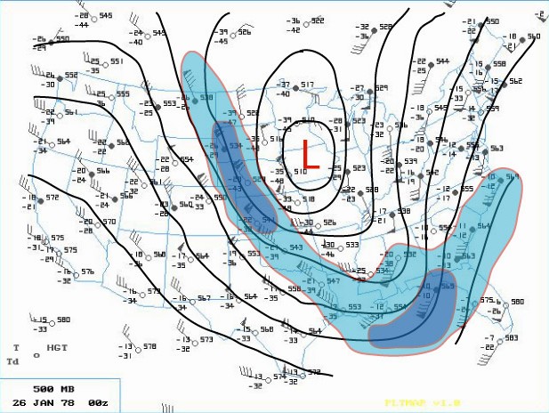
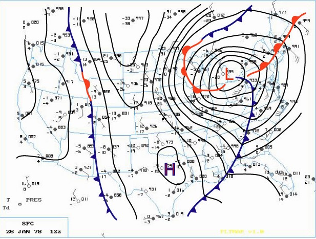
The aforementioned Arctic cold front that was across the Western Great Lakes advanced steadily east into Lower Michigan as the main southern low underwent explosive deepening (this low's central pressure fell 40 millibars in 24 hours)! The central pressure was recorded at 28.28 inches as it tracked north across eastern Ohio, just west of Cleveland, at 7AM EST. As the low moved out over Lake Erie, the Arctic cold front over Southeast Lower Michigan was pulled sharply east into it's mammoth cyclonic circulation. Any residual rain over Southeast Lower Michigan quickly changed to heavy snow and blowing snow during the pre-dawn hours of the 26th. As the Arctic front plowed through the Cleveland area, the wind gusted to an incredible 82 mph! As the Arctic air flooded the Cleveland area, the temperature dropped from a relatively balmy 44 degrees at 4AM EST to a bitterly cold 7 degrees by 1000 AM EST.

Blizzard Warnings were hoisted across much of the Great Lakes and Upper Ohio Valley Region by daybreak Thursday. The center of the huge storm (surface | 500mb) continued to trek north northwest across Southwest Ontario (roughly between Chatham and London) while Detroit measured its lowest pressure reading at 28.34 inches at 650 AM EST. The incredibly deep center made its way north along the St. Clair River with Sarnia ON reporting the lowest pressure on land at 28.21 inches. Not only was the depth of this mammoth storm's center very impressive, so too was the extent of low pressure from its center. Even locations that were far removed from the storm's center also reported record low pressures. Stations such as Cincinnati OH, Rochester NY and Toronto ON and even as far east as Wilmington N.C., all recorded record low pressure readings from this monster. In fact, at Toronto, where records go back as far back as 1840, the lowest pressure reading of 28.40 inches broke the old record of 28.57 inches by 0.17 inches. In addition, dozens of other cities, with records going back a century, also recorded their lowest pressure reading of all time or, for at least the month of January. This massively intense storm was responsible for strong wind gusts as far away from the center as Boston /72 MPH/ and Chesapeake Bay Bridge /90 MPH/ with even damaging winds reported as far south as Tallahassee FL.

As the Arctic air circulated throughout the storm while it made its way over Lake Huron, the lowest pressure was reached around 950 millibars or a hurricane-like 28.05 inches! "A Great Storm is Upon Michigan" read the headline of the 800 AM EST Special Weather Statement issued by the National Weather Service Forecast Office in Ann Arbor that Thursday /26th/ morning. Heavy snow and blizzard conditions were extensive as wind gusts in excess of 35 mph whipped the snow into huge drifts across much of Southeast Lower Michigan. Other areas of Eastern Michigan, Indiana and Ohio reported near hurricane-force winds, heavy snow and temperatures hovering between zero and 10 above, resulting in extreme blizzard conditions. These conditions later expanded further east into Pennsylvania and West Virginia and prevailed into the night (26-27th) across much of the Eastern Great Lakes, Southern Ontario and the Upper Ohio Valley. With the storm generating copious amounts of snow and very strong winds, whiteout conditions were widespread. All land and air traffic came to a stand still in the affected regions. Several major roads were closed for at least two to three days, if not longer, while clean up got underway. Numerous NWS employees were stranded at work, home, or on the road somewhere between the two. Several employees worked double shifts into at least Friday (some longer) because of the impassable roads with others simply unable to get to work.

The Blizzard Warnings were allowed to die across Michigan during the forenoon hours of Friday, the 27th. Record 24 hour snowfall totals from the storm included, 16.1 inches at Grand Rapids, 15.4 inches at Houghton Lake and 12.2 at Dayton, OH. Snowfalls for the entire storm (25-27th) included a whopping 30.0 inches at Muskegon (some of which was Lake Michigan enhanced), 19.3 inches at Lansing and 19.2 at Grand Rapids. Snowfalls were less over Southeast Lower Michigan (mainly because of the rain that fell for a period) and included 9.9 inches at Flint and 8.2 inches at Detroit.

The following is a quote from the summary written about the storm by Meteorologist in Charge, C.R. Snider on January 30th, 1978 at the National Weather Service Ann Arbor:
"The most extensive and very nearly the most severe blizzard in Michigan history raged throughout Thursday January 26, 1978 and into part of Friday January 27. About 20 people died as a direct or indirect result of the storm, most due to heart attacks or traffic accidents. At least one person died of exposure in a stranded automobile. Many were hospitalized for exposure, mostly from homes that lost power and heat. About 100,000 cars were abandoned on Michigan highways, most of them in the southeast part of the state."
The employees of the National Weather Service Forecast Office in Ann Arbor had just set up shop at the new quarters at the Ann Arbor Federal Building a WEEK before the storm hit. The forecast staff had transferred from the Detroit Metropolitan Airport Office while the observing and radar staff remained at the airport. The majority of employees still lived in and around the metro Detroit area and all major roads between Detroit and Ann Arbor were blocked for approximately 18 hours due to the storm. Several employees put forth efforts beyond the call of duty, stated Mr. Snider in his storm report.

Yet, as mentioned earlier, the Winter was not yet over by any means as the month of February (after the storm) was brutally cold across much of country. The below normal temperature departures of February 1978 were strikingly similar to that of January 1978 (and in some places, February was actually colder). The average temperature for Detroit that winter came in at just 20.5 degrees /normal 27.1/ which again, made it the seventh coldest winter on record. Snowfall totaled a hefty 61.7 inches which made the winter of 1977-78 the ninth snowiest winter on record at Detroit. Flint's average temperature of 19.1 degrees made it the fifth coldest winter on record, but Flint received less snow than Detroit with 50.6 inches. Saginaw's winter average temperature of 17.9 degrees made it the sixth coldest winter on record and was accompanied by 55.6 inches of snow. The 1977-78 snow season at both Flint and Saginaw has since dropped off the top 20 snowiest winters list.

More on the storm in surrounding areas can be found here.

Making weather fun while we all learn,
Bill Deedler -SEMI_WeatherHistorian


Jan 24, 2016

After a January Cool-Down to More Normal Temperatures the Past Few Weeks; Back to More Battles for the Second Half of the Winter?

A few weeks ago; I talked about El Nino taking a few week holiday and more typical winter weather would overspread and takes over the region. During the past few weeks, the main competitor for El Nino, was the "dreaded" or, our more typical mid-winter companion - the Polar Vortex. After pushing 4 - 6 degrees above normal the first third /10 days/ of the month, we were able to erase just about all of the above normal departures at Detroit /25.8, +0.3/ through the 24th. At both Flint and Saginaw; climate data still reflects a 2 to around 3 degrees above normal departure - mainly due to lower normal's at both sites and thus, larger above normal departures (remember; Detroit's normals have been inflated due to mainly, the large urban-heat affect).

In any event; we are now in transition again from the colder, more typical Polar/Arctic air dominance (or "Polar Vortex aided") back to a more mixed pattern, at least thru the first week of February. This is mainly due to the "bi-polar" Polar Vortex spinning around in the northern hemisphere and creating a variable NAO/AO  patterns the next few weeks. Initially; the NAO/AO retreats north-northeast and allows El Nino/Pacific Polar enhanced air to overspread much of the country again. This will produce a normal to above normal temperature pattern for the end of January across the Great Lakes and Southeast Lower Michigan. After; it appears the NAO/AO is in a major flux but with a decided negative direction after some sort of storm developing over the Midwest and Lakes Region early February.


Milder temperatures early in the week will bring some rain showers, while colder readings mid-week bring back some colder temps and snow showers but nothing major. Toward weeks end, a more zonal flow will commence off of the Pacific; overspreading the region with milder air once again over the weekend. The map below is an estimate of the 250 MB/~34KFT wind flow over the Northern Hemisphere by Sunday morning, 01/31/16

I started the blog with stating a more mixed pattern is evolving the next few weeks; after our milder, end of month pattern; February into March looks to be somewhat more active at times which also gets a thumbs up by our Winter Outlook guidance. The problem comes in just as it has much of the winter; nearly all of the major activity has been out West, East and South - actually the way it should during a strong El Nino.

From my earlier Outlook:


Snowfall/Precipitation

With snowy winters (above normal snowfalls) dominating the past 10 - 15 years, the season snow outlook for snow lovers is rather dreary. In fact, like the warmer temperature dominance this analogue go-around, snowfall averaged on the lightest side of past analogue winter totals seen at Detroit. Snowfall deficit runs from around a foot at Detroit to just a inch or so at Saginaw. This also fits with thinking of the polar jet still affecting the Lakes enough to bring near normal snows in that region.

However, all is not lost snowfall lovers! Two winters contained normal snowfall at Detroit, one normal and two above normal at Flint and finally; two normal and three above normal at Saginaw. Therefore, the most obvious pattern seen in these winters is that the further north one goes in Southeast Michigan, the better chance for more snow. The same can be said for general precipitation across the region. The Winters of 1991-92 and 1972-73 saw the best snows across the entire region with normal to above normal. The Winter of 1940-41 saw the next best "snow showing" the entire region but still well below at Detroit /26.8/ to near 50 at Saginaw /49.7/. The actual snow pattern for this winter will be watched for updates.

The best snows in the analogues on average were more likely to occur very early in the season, November and then again later in the season. November did indeed see above normal snowfalls with snowfalls running mainly below normal across much of the region since. There still is at least two and a half months for potential snowfall into mid April.

We shall see what winter's second half, snow-wise brings....

Look for any potential major storm updates through the rest of the winter.

Making weather fun while we all learn,
Bill Deedler -SEMI_WeatherHistorian


Jan 9, 2016

Say goodbye to El Nino - at Least for the Next Week or Two as a "Changing of the Guard" Takes Place

The unseasonably mild weather of December, for the most part, has held into the first week of January. Temperatures across Southeast Lower Michigan still remain 3 - 5+ degrees above normal for January and the new year. This has been due to two main hemispheric weather patterns; a stiff El Nino jet crossing the Pacific and flooding (some times quite literally) the country with mild and moist Pacific air and an absent Polar Vortex which has been mainly hanging around in its stomping grounds - obviously in and around the North Pole. This is in the process of changing this weekend as these dominant patterns, highlighted in the Winter Outlook for Southeast Lower Michigan  with reverse dominance over Southeast Lower Michigan. This was expected this winter when I discussed the overall winter pattern, in my interpretation of analogues and local data and thus - it was not going to be all comfy and warm due to El Nino.

As the Polar Vortex dives south toward southern Canada in the upcoming days; it will usher in the cold air that has been charging-up the first third of the winter up over the Pole while we basked in unseasonably mild air the past five weeks or so. Have faith though; the polar/arctic air associated with these Polar Vortex's is not as severe as last February's nor January, in the Winter of 2013-14. The cold air will surge south along with the Polar Vortex into mainly the North-central and Northeast part of the country. This "Changing of the Guard" will bring more typical winter weather into the region with normal to even below normal temperatures at times. At this time; the coldest of the air will come in waves with the first due tomorrow, then a reinforcement scheduled for Tuesday into Wednesday. Latest indications are a moderating trend is likely by weeks end before another shot of colder air pushes into the country next week.

The initial fanfare of the mixing of the air masses (mild, Pacific and Gulf air with Polar and Arctic air) will brew a deep but somewhat moisture limited storm over the southern Great Lakes and Northeast. While this storm will deepen nicely, there is not a great moisture supply feeding it, so all precipitation in the form of rain and then snow will be light to moderate.

As far as snowfall, generally light amounts of mainly 1 - 2" can be expected over most of Southeast Lower Michigan with patchy 3" areas over the Saginaw Valley into Monday. Be advised, heavier snows due to lake enhanced moisture will fall over on the west side of Lower Michigan and Northern Indiana this week where several inches will fall in the snow belt regions! If heading out that way; keep abreast to those regions GRR forecast IWX.  

The worst of the weather over Southeast Lower Michigan will be the plummeting temperatures along with the light snow and snow squalls and wind on Sunday which will undoubtedly give rise to worsening driving conditions due to the formation of ice underneath on untreated roads. Temperatures will dive down through the 20s on Sunday. Reading will fall further into the teens by Monday morning. Look for temperatures to be in the teens and 20s for highs this week while lows fall to around zero to the single digits on the coldest mornings.


Maps for placement of the storm and weather Sunday morning and Monday morning.


Gone But Not For Good

El Nino's not gone for good across much of the country - just temporarily. However; I do believe he will be challenged more than recently by the pattern changes and the cold winds over the far northern hemisphere, as agreed upon in my Outlook for mid and late winter. As of now;  he's taking a imposed vacation as the Polar Vortex and associated colder air takes up residence up in the northern part of the country. A split flow will hold sway of the country the next week or two with the aforementioned area reverting back to more typical winter weather, while the southern areas are more dominated by El Nino enhanced sub-tropical jet. Here are recent long term trajectory upper wind weather maps into next week. Of course the further out, the less reliable but their use for trends are decent. Any development of significant storms with these pattern variations are possible and thus, will be monitored the next few weeks.


Try to get out and enjoy winter while we have it - as later in the month is less certain at this time. Look for updates regarding pattern reversals and/or resulting storms.

Making weather fun while we all learn,
Bill Deedler -SEMI_WeatherHistorian


Dec 26, 2015

Update 12/27/15 - Look for a New Battle of Air Masses and Jets to Commence at the Week's Open to Top off an Exceptionally Warm December!

 Update - 12/2715 

Freezing Rain and Strong Easterly Winds to Cause Problems in Areas with the Longest Periods of Freezing Rain Monday Afternoon into Early Night

Very little change to original analysis: 
If anything I am even more definite on the freezing rain and associated problems along with the strong gusty easterly winds which will accompany the battle of the systems mentioned below. Look for mixed precipitation to over spread Southeast Lower Michigan from south to north during the afternoon on Monday. Most of the freezing precipitation from this system should be in the form of sleet then freezing rain as a thicker warm wedge of air surges north quickly on the southern jet over the colder, relatively drier Polar air. Freezing rain will become rain during the evening into night from south to north with time.

Strong high pressure in excess of 1040+ MB will but-up against the deep but slowly weakening low pressure over the middle Mississippi and cause a decent period of freezing rain. Most of the region, especially away from the Southeast corner has the biggest risk of ice build-ups up to around .2" with some "hold-out freezing or below temperature areas" from Detroit suburbs northward of around .2" - to as much as .4 - .5" of ice possible. This along with strong easterly winds of 20 to 30 mph with gusts to near 40 will bring the risk of icy roads and falling weaker tree limbs and power outages where conditions hold on the longest before the changeover. Temperatures hovering from upper 20s to lower 30s early in the event will gradually rise into the lower to mid 30s by evening.


Original Post 12/26/15

Earlier in the month, I sent out a blog about how the second half of the month would see a resurgence of the battle of the two distinct air masses that would dominate our winter weather. I stated it would not all be about El Nino this winter and from time to time, an impressive battle would brew between the Pacific energized El Nino jet stream and the Polar/Arctic jet stream. All indications are a new battle will commence in style early this upcoming week but first; lets look at this exceptional December...

Thus far this December has held true to form for an El Nino December with unseasonably warm weather, so much so, it should be at the top of the warmest Decembers on record at all three sites; Detroit, Flint and Saginaw! Even though cooler weather is expected this upcoming week; it shouldn't be enough to knock Detroit's standing out of first place while both Flint and Saginaw are more than safe.

In our analogue section for this winter; December had the best chance at being above normal and notably so - but admittedly, not ranking in first place. In the December analogues, there were three distinct very mild Decembers; 1877 - 38.1, 1940 - 35.6 and 1982 - 37.3. Overall; early in the game, the Winter of 1940-41 seemed to be the best analogue fit for the entire winter but with the two very strong El Nino's of 1982-83 and 1997-98 contending for very close seconds. In winter of '97-98, which arguably has had a very good showing for similar Pacific "goings-on" this past summer into early winter, its December locally though was not all warm as this years - nor the other three mentioned. December of '97 had an average temperature of just 32.2 (didn't even make the top 20 warmest Decembers). The exceptional warmth occurred later in that Winter of '97-98.

Top 20 Coldest/Warmest Decembers in Southeast Lower Michigan
Rank Detroit Area* Flint Bishop** Saginaw Area***
Coldest Warmest Coldest Warmest Coldest Warmest
Temp Year Temp Year Temp Year Temp Year Temp Year Temp Year
1 17.8 1876 42.2 2015 16.1 1989 42.42015 16.2 1989 40.62015
2 18.0 1989 40.6 1881 16.6 2000 37.2 1982 17.2 2000 35.3 1923
3 19.2 2000 39.3 1889 17.4 1976 36.8 1923 18.8 1983 34.5 1982

The second half of December has not all been tranquil and nice as our former air mass battle that occurred last week; brought an outbreak of severe weather over the Midwest and South - and a very rare tornado in Southeast Lower Michigan near the border of Canton and Plymouth. Never had a tornado been reported in Michigan during the month of December - a very rare bird indeed! This severe weather outbreak across the country was preceded by record warmth over the Midwest and East. Detroit broke an very old record high from 1893 /56/ with a 58 on the 23rd...while Flint topped the 60 mark with a 61 for both the 23rd/24th. Its previous records occurred in 1982 (an analogue) with 55 and 56 respectively. Other warm records occurred during the month and can be found here.

Now on to our new battle...

This time around an intense low pressure center over Texas expected to produce a news worthy blizzard over portions of eastern New Mexico and western Texas (see map) overnight into Sunday.

Dawn Sunday 12/2715


The deep low will track north northeast aided by a strong jet streak over the south which came aboard from the Pacific. Note the 135K jet feeding into the storm at 250 MB at that time.


As the low approaches, the cold dome of high pressure will glide across Southern Canada. Timing of these systems, along with cold air in place after being advected in Sunday by the high pressure will determine what sort of mess  (snow, sleet and freezing rain) will be on the docket for Monday and Monday evening. in addition; ground temperatures are unusually warm for late December which only complicates matters. At this time, the risk of mixed precipitation will be the greatest at the onset of the approach of the low later Monday.

The surge of moisture remains robust even with the cold, dry air and subsidence advected in by the 1040+ high pressure - a fairly impressive strength. And thus, our battle commences locally between the deep low moving north northeast toward
western Illinois/eastern Iowa and large Polar high to our northeast in Canada. this will also create strong easterly winds across the region. One thing noted at this time is the remarkable agreement with various models on positioning and affects of the aforementioned systems.

It's interesting and passing to note, a few days ago this storm was progged to move more northeast into the Ohio Valley, which would have put Southeast Lower Michigan in heavy snow and/or a possible ice storm. That solution remains more transitory at this time as the air masses and jets have become bettered sampled. That is not to say Southeast Lower Michigan is out of the woods for mixed precipitation and possible icing, just not extent that was telegraphed a few days ago. This system appears to have enough wind at its sail to surge far enough northward to drag milder air back over the region.

At this time; the best chance for mixed precipitation runs from Monday afternoon into mid evening; the map below /Mon, early eve/ shows the classic mixed precipitation of snow, sleet and freezing rain set up when the clash of air masses takes hold over a the region. Picture warm, moist air being pushed northward aloft while colder, around freezing or below air remains trapped below near the ground. If a stand-off develops, an extended period of mixed precipitation, including destructive freezing rain as it accumulates on surfaces. The warm air is expected to win the battle and therefore, an extended period of freezing rain is not anticipated. However, the situation will be watched as new guidance and actual events unfold.


In any event, look for a mix of precipitation to move into the region later Monday into Monday evening with icing to affect mainly "exposed in the air items" as opposed to warmer ground surface areas, including roadways. Temperatures should hover in the lower to mid 30s for a time until the low pressure and jet streak has enough "umph" to push aside the cold residual affects of the high pressure. Any mixed precipitation accumulation is expected to be limited and transitory over extreme Southeast Lower Michigan with a slower change over time as one moves into Detroit's northern suburbs and points north and northeast toward Saginaw and the Thumb. At this time I look for ice to accumulate any where from a trace over the extreme southern regions to up around a 1/4" possible further north before any changeover to rain.

Various model solutions for Mon eve:


 Any important updates will be forthcoming for this holiday period.

Making weather fun while we all learn,
Bill Deedler -SEMI_WeatherHistorian


Dec 19, 2015

Ghost of Christmases Past; The Whitest of Christmases and Other Christmases Past - 2015 version

The Whitest of Christmases and Other Christmases Past 
 
By: William R Deedler; Southeast Michigan Weather Historian
Date: 4PM Saturday Dec 19th, 2015
 

Frequently during the Christmas Season, meteorologists are asked; Are we going to have white Christmas?  Generally, it is agreed among meteorologists that in order to "officially" have a white Christmas, an average of an inch of snow must cover the ground, but not necessarily have to fall on Christmas. 

At this time /19th/, at this time it is highly unlikely for a white Christmas across Southeast Lower Michigan even though temperatures should drop some for Christmas after a cold front pushes through, reading should still be above normal into the 40s with no or little precipitation. In fact, at this time the weather looks very conducive for holiday travel across Southeast Lower Michigan with tranquil weather.

Over the years extreme Southeast Lower Michigan has averaged about a 50 percent chance for a white Christmas.  Some years it's already on the ground, some years not, some years it melts while other years it falls on the day.  Now officially there must be an inch of snow on the ground Christmas MORNING at 7am. That is how the official "white Christmases" have been tallied in the past. So theoretically, you could actually have nothing on the ground Christmas morning and have a snowstorm dump a foot on the region during the day and still have NO official white Christmas under the standing rule. It works the other way too; you could have a several inches on the ground at 7am 12/25 but warmer air and/or rain melts it away by afternoon or evening and still officially have a white Christmas.

Last year's December /2014/ and Christmas time was very similar to this year's with record setting low amounts of snow for the month (in the top 5 snowless) and the chances for a white Christmas last year, also being almost non-existent. Even with the normal snowfall throughout last winter, officially on 12/25/14 at 7am; Detroit Metro Airport only a TRACE of snow that fell for the month with nothing on Christmas nor on the ground at Detroit Metro Airport. Most areas into the remainder of Southeast Lower Michigan had a few tenths Christmas eve or Christmas but with less than the amount needed and mild temperatures rising into the upper 30s to around 40...none of the area saw a white Christmas. 

Previous recent Christmases:

In 2013even with all the snowfall throughout last winter, officially on 12/25/13 at 7am Detroit Metro Airport had only a TRACE of snow on the ground. Most areas into the remainder of Southeast Lower Michigan had some residual snow and ice on the ground for a white Christmas. Back in 2012, enough snow did fall at Detroit Metro Arpt (an inch of fresh snow Christmas Eve) to make it an official white Christmas was on the ground as of 7AM. The necessary inch or more was also on the ground at both Flint and Saginaw. Ironically the day after Christmas, the best snowstorm of the winter season hit the region...a day late and several inches short for Christmas. A year earlier in 2011, it was a relatively mild Christmas with temperatures in the 40s and no snow on the ground; so no white Christmas. However back in 2010; residents across Southeast Lower Michigan did enjoy a white Christmas with generally 1” to 6” of snow across as temperatures hovered in the 20s. Then further back in 2009, much of the Detroit area south did not have a white Christmas but points north across Flint, Saginaw and the thumb region generally had a 1” to 3” snow cover. Back in 2008, we saw a “sloppy, melting white” Christmas. That white Christmas involved the melting of a heavy snow cover from past snows that accumulated throughout December. The best of the snowstorms came before Christmas on the 19th (with another, lesser intense snow falling on the doorstep of Christmas, 23rd -24th). After, however, the heavy snow cover melted in earnest as milder air overspread the region Christmas Eve right through the 26th. Christmas of 2007, saw temperatures rise into the mid 40s to mid 50s a couple of days prior to Christmas and that, combined with light rain, pretty much took care of any hopes for a white Christmas as then, like the later Christmas of 2008, the  previous heavy snow cover melted (but this time in its entirety before Christmas). Some scattered light snow did return, skirting the landscape on Christmas Eve but most areas around Southeast Lower Michigan still only had a trace of snow for Christmas. At White Lake and Saginaw, however, the official inch of snow to make it a white Christmas was barely attained in 2007.

Going back further to the Christmas of 2006; it was also mild and therefore, there was no white Christmas. In 2005, we just barely squeaked out a white Christmas (at Detroit Metro Airport, anyway) as a mild spell moved in just before Christmas along with rain, melting the snow down from 4” to 1” by Christmas morning. Originally, there had been 8” of snow on the ground on the 15th. The last really scenic (no slop)  with fresh white snow for Christmas occurred in 2004. A snowstorm brought heavy snow (ranging from 8”at Detroit to around 4” in Saginaw and Flint) on the 23rd, which left the region with a nice white cover for Christmas. It was also a cold Christmas also with highs only in the teens and overnight lows below zero. 


Looking over historical weather records of Christmases past since 1900, a wide range of weather conditions were found. While most people would like to believe that Christmas in the Detroit area should be snowy-white and picturesque, more often than not, they're not. Over the past 115 (including 1900) Christmases in Detroit, 54 (47%) have been what would be called "white" with an inch or better of snow on the ground. Keep in mind however, these records are for Detroit; farther north in Flint, the chance of a white Christmas jumps to 56 percent, while in Saginaw and the Thumb region it rises to 61 percent.

Based on the Detroit records, the Santa award for the "whitest" (most snow on the ground) and also the second snowiest Christmas (snow falling on Christmas) goes to the Christmas of 1951! Just over a foot /13 inches/ of snow was recorded on ground late Christmas day with 6.2 inches of the snow falling on Christmas. Temperatures held well below freezing (HI-26/LOW-18), so what snow did fall, remained. A close second to the "whitest" Christmas, occurred the Christmas after the big stock market crash in 1929. Eleven and a half inches of snow was measured December 25th, 1929 at Detroit but only three tenths /.3/ fell on Christmas. Recently, the Christmas of 2000 was very white indeed, but as to how much of a white Christmas (snow depths) is where the confusion came in. Let me elaborate, officially at Detroit Metro Airport, just six inches of snow was recorded on the ground at 7AM Christmas Day. However, just about anywhere west/north and in the city of Detroit itself, amounts were considerably higher with generally 8 to at least 15 inches. At the National Weather Service in White Lake, 15 inches was observed on the ground Christmas 2000 morning. No additional snow fell on Christmas Day (nor was anymore really wanted with the surplus already at hand). In any event, for Detroit and surrounding communities, the six inches at Detroit Metro Airport is the official snow depth used for the area.

The snowiest Christmas (most snow falling on Christmas), occurred in 1915 when 6.4 inches fell with a snow depth of seven inches on the ground. The timing of this snowfall was impeccable for Christmas with it actually starting Christmas Eve around sunset. Then, it continued to snow through the night into Christmas day. Actually, even more than the 6.4 inches fell from the entire storm with an additional 1.6 inches falling on Christmas Eve. This gave a snowstorm total of eight inches.  A little light rain did mix with the snow during the forenoon hours of Christmas but with a high temperature of only 33, it did little to mar the "Christmas card" scene. Speaking of "Christmas card" scenes, another heavy wet snowfall blanketed the area just after the turn of the century early on Christmas in 1901. The scene is described in the historical weather books as follows:


    "Night of the 24 - 25 cloudy; moist snow continued,
     heaviest between hours of 1:30 and 4:30 am, ended
     at 6 am. amount of precipitation .62 inches. The
     street cars ran all night to keep the tracks open.
     the snow adhered to trees etc, and made a very
     beautiful scene. Depth of snow on ground at 8 am,
     5.5 inches".


 This "Norman Rockwell Christmas scene" was further enhanced by a heavy coating of frost deposited on the buildings and windows Christmas Eve due to the moisture-laden air. But just like memories of some Christmases past, this majestic Christmas scene quickly faded (melted) during the day as temperatures climbed to 41 degrees, leaving just slush , slop and water. During the Christmases of 2002 and 2003, the weather was similar to both of the white Christmases mentioned above /1901 & 1915/. Here again in 2003, snow started falling Christmas Eve and lasted into at least part of, if not all of Christmas Day. On Christmas Day 2003, snowfalls ranged from at least an inch in the far southeast corner of Lower Michigan to as much as six inches across Detroit's northern suburbs, extending northward across Flint and Saginaw. On Christmas Day of 2002, total snowfall at Detroit Metro Airport was measured at 6.4” inches for both days (Christmas Eve and Christmas) with 3.4” of it falling on Christmas Day, itself. Across all of Southeast Lower Michigan snowfalls generally ranged from four to seven inches. A picture perfect Christmas was created both years with the freshly fallen snow. Like the Christmas snowstorms of 1901 and 1915, the snow Christmas 2002 was also somewhat heavy and wet with high temperatures in the lower 30s and lows only in the mid 20s.

Probably one of the slushiest and sloppiest Christmas Days happened in 1973. What started out as a white Christmas with a heavy 7 inch snow cover, quickly melted to a meager 2” slush mess by nightfall. To add insult to injury, it rained nearly a half an inch during the day.The wettest Christmas on record occurred in 1945 when 1.16 inches of rain fell. The rain actually began Christmas Eve as a light freezing rain and continued freezing until nearly dawn on Christmas, when the temperature pushed above freezing. Until the ice melted, a few tenths of an inch of ice coated everything by Christmas dawn. Needless to say, walking and driving early the Christmas of 1945 was treacherous but Santa was in and out of town in a flash!

Without a doubt, and still in the memories of long term inhabitants of Southeast Lower Michigan, is the warmest Christmas on record, the Christmas of 1982. It was as though the whole area was shipped to Florida for the holiday! The official record high at Detroit was 64 degrees, while Flint did one degree better at 65! These readings are about normal for Tallahassee, Florida! Scenes of shirt sleeved people with shorts running or riding bikes, instead of visions of sugar plums, made the Christmas of 1982 to some Michigan Christmas traditionalist, very hard to take.  This spring-like day was complete with scattered showers and, of all things, thunderstorms! Ironically, the bitterest cold Christmas came just a year later in 1983! Maybe a payback from Mother Nature for the warm weather we were treated to, the Christmas past? The temperature plummeted Christmas eve to a record low of -9 at Detroit and was accompanied by a stiff west wind averaging 25 to 30 mph, creating life threatening wind chills at times of near 40 below zero! Santa certainly brought the North Pole with him the Christmas of 1983, when he made his rounds very early that morning. In addition to the record low Christmas eve, another record low /-10/ was established during the very early morning hours of Christmas.

These Christmases past discussed are more the extreme than the norm across extreme Southeast Lower Michigan. But they do show the variable weather that can occur at Christmas (or any other time for that matter). The "normal" (or average) highs in extreme Southeast Lower Michigan Christmas Day are in the lower 30s, while lows average in the upper teens.

And now, I'd like to wish all who read this a very Merry Christmas and/or Holiday Season and the best in 2016! I plan on continuing my blog for the new year if the fates allow and look forward in reaching out to more people (and hear their comments and ideas) across the globe.

Making weather fun while we all learn,
Bill Deedler - SEMI_WeatherHistorian