Mar 2, 2014

Spring 2014 Outlook For Southeast Lower Michigan

After one very cold and snowy winter that really has yet to complete its run; it might sound a bit premature to talk about spring. However, officially by meteorological calendar standards /Mar - May/ we have now entered spring. And yes, as you pretty well expect, the next several days in the first week of March are going to feel like the last several with no really discernible difference. But what does the spring season on the whole look like as far as temperatures and precipitation when researching past analogue seasons that portrayed our cold winter the best. And, what about model projections for the spring season, do they agree or disagree with the analogues?

Temperatures:

Look for temperatures to average below normal to normal with three month departure below the normal spring temperature. See reasoning below...

Precipitation:
Look for precipitation to average normal to below with the three month departure below the normal spring precipitation. See reasoning below...


ENSO

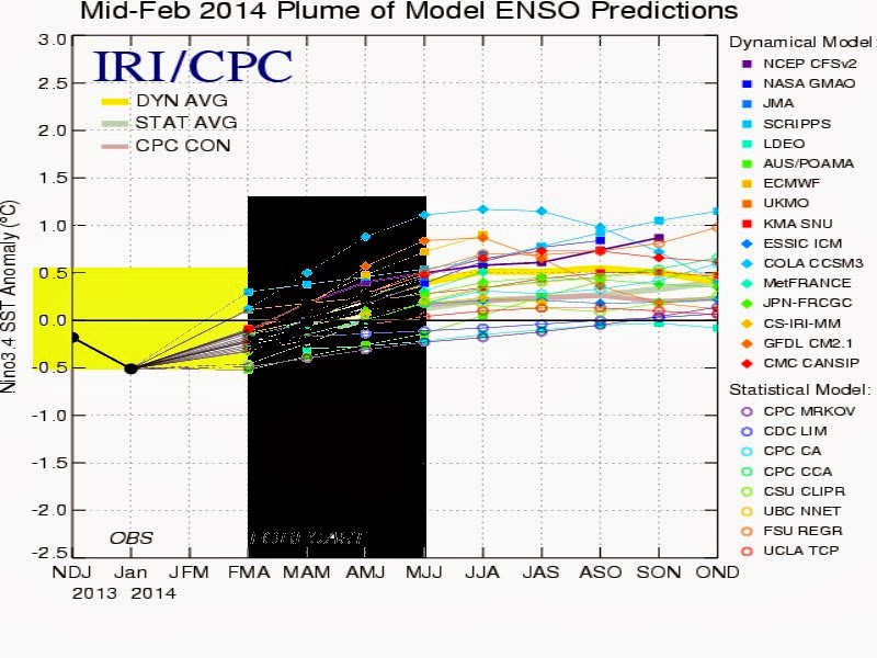
Little overall change is expected on the larger hemispheric scale as far as ENSO this spring as neutral conditions continue in the Pacific. As one can see by computer Pacific SST projections; little if any influence is expected from that region for the world.


Spring 2014 Analogues

The spring analogues were chosen as a subset of the winter analogues that performed the best in relation to temperature and lesser extent, snowfall. The original raw set of Winter 2013-14 analogue winters projected a colder than average winter with variable amounts of snowfall possible. From there, I narrowed it down by mid January to the coldest of winters with near normal to above in snowfall. these six winters were used in our spring outlook. The normals, averages for the six winters and departures are displayed on the bottom of the chart. The best performing analogues, 1981-82 and 1880-81 are displayed on the top of the chart. Remember; these analogues reflect what happened locally in Southeast Lower Michigan (using metro Detroit's data for the spring) in the past under similar hemispheric conditions. It's mainly their general temperatures/precipitation and trend that is most important and to a lesser extent, their numerical departures.


Immediately one can note these springs were not the nicest as far as temperatures (see color legend).  Four out of the six springs went on to be colder or below normal as far as temperatures. The other two, averaged in the normal camp with no above normal springs seen (far right column, under spring average). The real drain on the spring temperatures were the colder than normal Marches and Aprils. Early in the spring anyway, showed the best chance of averaging below normal with three Marches below normal and three near normal. Narrowing this down further, when using our two best analogues for the winter, Winter of 1981-82 and Winter of 1880-81 both following Marches were colder or below normal. Moving on to April, three Aprils averaged below normal and two ranked near normal and one in fact, averaged above normal /4/1899 - 50.5/ +1.2/. However, when averaging the six Aprils in the analogue set, the average came in at 2.6 below the normal of 49.3 degree and almost identical to the March departure of 2.5 below it's normal of 37.2. In addition, again using our two best winter analogues, 1981-82 and 1880-81, both Aprils averaged decidedly below normal. Ironically; both March and April of 1982 and 1881 averaged similar temperatures with above average snowfall in Detroit. It will be interesting to see if this plays out a third time or the present cold and snowy pattern is cut off quicker than in those two analogue years. The most striking change that was seen in the analogues was the warmer or above normal Mays. Out of the six Mays, three averaged above normal, two averaged near normal and just one below normal. Was the polar cold was finally exhausted and the dominant upper wind pattern modified and changed? It appears that way. This is at least, encouraging for warmer than normal times ahead in mid to late spring, anyway.

Therefore; while the majority of springs started out with below normal temperatures, a subtle trend back to normal and even above normal could be summarized as the springs unfolded. This would seem to have logical support when one considers the gradual melting of the snow along with the extensive ice cover on the Great Lakes. This surface moderation along with a gradual relaxation of the predominant northwest upper jet stream looks subtle to the analogue results. Or, in other words, the previous cold analogue winter guidance and resultant extensive ice cover of the Great Lakes and bountiful snow cover (as seen in our two best analogues); encouraged a longer lag of below normal temperatures in the spring season than usually seen.

Spring Precipitation

Overall, spring precipitation averaged around normal to below in the analogue years. On average, normal to above normal precipitation early in the season gave way to normal to below normal later in the season. Five out of the six springs contained a notable dry period with the best chance being in April or May.  Early in the season was feast or famine for snowfall with half of the sample containing above normal snowfall and half below; the aforementioned analogue years 1982, 1881 along with 1899 contained well above. It should be noted freezing precipitation also was noted these years.

Severe Weather Seasons (into the summer)

Looking over the severe weather stats for the analogue years since 1980 (locally) and 1961 (tornado stats map from SPC), The analogue years averaged normal to below normal for severe weather. Perhaps this is not surprising since many of the  analogues averaged colder than normal and when it did warm up, precipitation amounts dropped off comparable to normal. Of course; there were a few busier years but more occurred in the summer, which is typical anyway.

Severe Weather Stats for Analogues from 1980 to 2006; note the average amount on the bottom was 45 days.

Annual Totals
Year
Hail
Wind
Tornado
Total
Rpt
Days
Rpt
Days
Rpt
Days
Rpt
Days
1980
58
17
186
32
29
16
116
37
1981
13
7
54
21
5
3
23
22
1982
45
15
117
19
17
9
79
28
1983
86
15
283
30
22
12
130
34
1984
31
12
79
29
20
12
71
39
1985
103
16
158
22
13
9
129
31
1986
72
21
165
36
34
19
140
46
1987
30
16
196
31
16
13
62
38
1988
75
22
198
35
19
10
113
40
1989
32
17
128
30
19
13
70
38
1990
33
16
141
21
23
12
79
27
1991
78
24
320
39
29
10
136
46
1992
66
24
262
32
52
16
170
42
1993
61
22
168
29
8
7
77
37
1994
159
30
239
37
12
8
183
48
1995
76
27
272
41
8
5
92
48
1996
120
35
244
41
14
8
148
56
1997
118
30
330
39
21
5
160
45
1998
270
36
595
39
28
16
326
52
1999
165
28
385
40
15
9
195
45
2000
292
30
381
46
16
9
324
53
2001
198
39
356
53
41
11
280
66
2002
145
39
394
53
22
6
189
62
2003
359
42
559
47
17
12
393
55
2004
326
45
489
45
22
10
370
60
2005
164
32
523
38
3
3
170
48
2006
424
50
404
49
12
9
448
70
AVG
133
26
282
36
20
10
436
45
 
                                                                                                                                                                                                                                                                                                                                                                                                                    Tornado occurrences/ranks in all analogue years since 1961


Computer Model Temperature Outlook for Spring in Southeast Lower Michigan

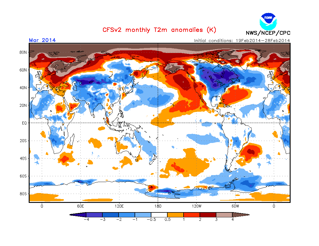
Looking at the computer model /CFSv2/ temperature outlooks for first the entire spring season and then, by monthly projections shows very strong support for the analogues. As one can see, below normal temperatures (blue shading) are suggested for the entire Great Lakes region for the spring as a whole. Interesting how this latest computer projection nearly duplicates local findings, right down to the month.


Monthly Breakdown of Temperatures


During the next few months; I'll have more posts on the Historic Winter of 2013-14.

Making weather fun while we all learn,
Bill Deedler -SEMI_WeatherHistorian


Feb 22, 2014

2/28/14 -Update & Results The Anatomy of Our "Polar Vortex" Visit Late Next Week

-Update 2/28/14 Temperature Results

An extremely cold morning was felt for the last day of February and also was appropriate enough for the last day of the meteorological winter /Dec-Feb/ -  a record winter in many ways that was very cold and snowy. We'll take a look at the temperatures and snowfall in the meteorological winter of 2013-14 and the final snowfall for the snowfall season of 2013-14 in the coming weeks. Meanwhile; check out these low temperatures on the last morning of the meteorological winter.
Next; Spring 2014 Outlook


MORNING TEMPERATURE AND PRECIPITATION SUMMARY
NATIONAL WEATHER SERVICE DETROIT/PONTIAC MI
1124 AM EST FRI FEB 28 2014

VALUES REPRESENT YESTERDAY`S HIGHS....LOW OVER THE LAST 12 HOURS
AND PRECIPITATION OVER THE LAST 24 HOURS ENDING AT 7 AM EST


.BR DTX  0228  ES DH00/TAIRZX/DH07/TAIRZP/TA/PPDRZZ/SFDRZZ/SDIRZZ


:SOUTHEAST MICHIGAN -- TEMPERATURE AND PRECIPITATION STATIONS
:....................................................................
:       STATION              MAX / MIN  / 7 AM  / 24-HR / SNOW/ SNOW
:        NAME                TEMP/ TEMP / TEMP  / PRECIP/ FALL/ DEPTH
:....................................................................
WHKM4: NWS WHITE LAKE      :   16 / -18  / -17  / 0.00  /  0.0 / 16
ADG  : ADRIAN AIRPORT      :   15 /  -8  /  -7  /
123M4: ANN ARBOR           :   13 /  -5  /  -5  / 0.02  /  0.4 / 13
BAX  :*BAD AXE AIRPORT     :   10 / -20  / -20  /
CFS  :*CARO AIRPORT-TUSCOLA:   11 / -18  / -18  /
DET  : DETROIT CITY AIRPORT:   15 /  -1  /   0  /
DTW  : DETROIT METRO ARPT  :   15 /   0  /   0  /    T  /    T / 12
FNT  : FLINT BISHOP AIRPORT:   14 / -16  / -14  /    T  /    T / 11
ONZ  :*GROSSE ILE AIRPORT  :   16 /   1  /   1  /
OZW  :*HOWELL AIRPORT      :   12 / -10  /  -9  /
DUH  :*LAMBERTVILLE AIRPORT:   19 /   0  /   0  /
D95  :*LAPEER DUPONT AIRPRT:   12 / -19  / -19  /
IKW  :*MIDLAND AIRPORT     :   11 / -19  / -19  /
TTF  :*MONROE AIRPORT      :   16 /  -2  /  -2  /
RNP  :*OWOSSO AIRPORT      :   12 / -12  / -11  /
PTK  : PONTIAC AIRPORT     :   12 / -11  / -10  /
P58  : PORT HOPE           :    M /   M  /   M  /    M
PHN  :*PORT HURON AIRPORT  :   12 / -18  / -18  /
MBS  : SAGINAW - TRI-CITIES:   12 /  -8  /  -6  /    T  /    T / 19
HYX  :*SAGINAW-HARRY BROWNE:   12 /  -9  /  -8  /
VLL  :*OAKLAND/TROY AIRPORT:   14 /  -2  /  -2  /
YIP  : YPSILANTI WILLOW RUN:   17 /  -7  /  -6  /
.END


*THE TEMPERATURE DATA FOR THESE SITES ABOVE REPRESENT THE HIGHEST AND
 LOWEST TEMPERATURES THAT WERE REPORTED ON THE METAR OBSERVATIONS
 THAT TRANSMIT THREE TIMES AN HOUR AND MAY NOT REPRESENT THE ACTUAL
 HIGH OR LOW FOR THAT SITE. SOME OF THESE SITES DO NOT MEASURE
 PRECIPITATION.
.....................................................................


THE FOLLOWING COOPERATIVE OBSERVER SITES REPORT FROM MIDNIGHT TO
MIDNIGHT EST.


.BR DTX  0228  ES DH07/TAIRZX/TAIRZN/TA/PPDRZZ/SFDRZZ/SDIRZZ


:SOUTHEAST MICHIGAN -- TEMPERATURE AND PRECIPITATION STATIONS
:....................................................................
:       STATION               MAX / MIN  / MIDNITE/24-HR / SNOW/ SNOW
:        NAME                 TEMP/ TEMP / TEMP  /PRECIP/ FALL/ DEPTH
:....................................................................
ARNM4: ADRIAN              :   15 /  -2  /  -2  /    T /  0.2 / 4
MILM4: MILFORD- GM PRV GNDS:   11 / -10  / -10  /    T /    T / 8
MDLM4: MIDLAND             :   11 /  -6  /  -5  /    T /    T / M
MTCM4: MT CLEMENS SELFRIDGE:   14 /  -2  /  -1  / 0.01 /  0.3 / 3
PRHM4: PORT HURON          :   12 /   0  /   0  /    T /    T / 6
SGNM4: SAGINAW 5W          :   10 /  -9  /  -8  / 0.04 /  0.7 / 19
.....................................................................


COOPERATIVE OBSERVATIONS VALUES ARE FOR APPROXIMATELY 24 HOURS FROM
PREVIOUS OB TIME TO CURRENT OB TIME.


.BR DTX  0228  ES DH07/TAIRZX/TAIRZN/TA/PPDRZZ/SFDRZZ/SDIRZZ


:..................................................................
:       STATION           OB   /MAX / MIN  /OB  /24-HR /SNOW/SNOW
:        NAME             TIME /TEMP/ TEMP /TEMP/PRECIP/FALL/DEPTH
:..................................................................
: ***BAY COUNTY***
AUBM4:  AUBURN            :0630/  8 / -17 / -17 / 0.00/   M/6


  ***MIDLAND COUNTY***
OILM4:  OIL CITY          :0700/  7 / -25 / -24 /    T/   T/17


: ***HURON COUNTY***
BDAM4:  BAD AXE           :0700/  8 / -14 / -14 / 0.00/ 0.0/13
FLNM4:  FILION 5NNW       :0630/  7 / -19 / -18 / 0.01/ 0.2/13
POAM4:  PORT AUSTIN       :0740/  9 / -12 / -10 / 0.00/   M/7
PHPM4:  PORT HOPE         :0800/  8 / -13 / -11 / 0.00/ 0.0/14


: ***SAGINAW COUNTY***
CHSM4:  CHESANING         :0730/    /     /     / 0.00/   M/8
FKMM4:  FRANKENMUTH 1SE   :0805/  6 / -16 / -14 / 0.00/   M/15
MERM4:  MERRIL 2E         :0800/  8 / -16 /  -5 / 0.00/   M/M
SAGM4:  SAGINAW           :0800/  8 / -13 /  -9 / 0.00/ 0.0/7


: ***TUSCOLA COUNTY***
CARM4:  CARO              :0920/  8 / -20 /   0 / 0.00/   M/9


: ***SANILAC COUNTY***
LEXM4:  LEXINGTON         :0730/ 10 / -11 / -11 / 0.02/ 0.2/11
MRLM4:  MARLETTE          :0700/  6 / -15 / -14 / 0.00/   M/6
SANM4:  SANDUSKY          :0642/ 15 / -14 / -14 / 0.00/   M/16


: ***SHIAWASSEE COUNTY***
CORM4:  CORUNNA 2NE       :0600/ 12 / -14 / -14 / 0.02/ 0.5/7
OWSM4:  OWOSSO            :0700/ 10 / -11 /  -7 / 0.00/   M/14


: ***GENESEE COUNTY***
BUNM4:  BURTON 4N         :0700/ 11 / -18 / -17 / 0.00/   M/11
LIDM4:  LINDEN            :0845/  8 / -13 /  -3 / 0.00/   M/7
GODM4:  GOODRICH          :0730/ 10 / -17 / -15 / 0.00/   M/6


: ***LAPEER COUNTY***
LPEM4:  LAPEER 2W         :1030/ 12 / -19 /  12 /    T/   T/10


: ***ST. CLAIR COUNTY***
YALM4:  YALE              :0655/ 10 / -18 / -18 / 0.01/ 0.2/20


: ***LIVINGSTON COUNTY***
HELM4:  HELL              :1050/  9 / -16 /   9 / 0.00/   M/9
HOWM4:  HOWELL            :0749/ 12 / -16 /  -6 /    T/   T/13
WHLM4:WHITMORE LK 1N      :0700/ 10 / -16 / -16 / 0.00/ 0.0/9


: ***OAKLAND COUNTY***
FARM4:  FARMINGTON        :0730/ 11 /  -9 /  -9 / 0.00/   M/9
WSBM4:  WEST BLOOMFIELD   :0700/    /     /     / 0.00/   M/14


: ***MACOMB COUNTY***
RICM4:  RICHMOND 4NNW     :0800/ 12 / -13 / -12 /    T/   T/12


: ***WASHTENAW COUNTY***
AASM4: ANN ARBOR-SOUTHEAST:0730/ 12 / -10 / -10 / 0.02/ 0.4/13
CHLM4:  CHELSEA           :0934/ 10 / -16 /   0 / 0.00/   M/11
MCHM4:  MANCHESTER        :0700/ 12 / -13 / -13 /    T/ 0.2/15
SLNM4:  SALINE 4SW        :0800/ 13 / -13 /  -4 / 0.00/   M/M
SALM4:  SALINE            :0840/ 14 / -15 /  -6 / 0.02/   T/6


: ***WAYNE COUNTY***
DBNM4:  DEARBORN          :0700/ 13 /   0 /   0 / 0.00/   M/6
GPFM4:  GROSSE PTE FARMS  :0800/ 13 /  -3 /   2 / 0.00/ 0.0/6
WYTM4:  WYANDOTTE         :0800/    /     /     / 0.01/ 0.2/12


: ***LENAWEE COUNTY***
BLIM4:  BLISSFIELD 1SW    :M   /  M /   M /   M / 0.01/   M/M
MRIM4:  MORENCI           :0730/ 16 /  -8 /  -7 /    T/   T/8
TECM4:  TECUMSEH          :0630/ 16 / -10 /  -8 / 0.00/   M/4
TIPM4:  TIPTON 2WNW       :1000/ 15 /  -8 /  10 / 0.00/   M/12


: ***MONROE COUNTY***
DNDM4:  DUNDEE            :0700/ 12 /  -4 /  -4 /    T/   T/6
MLIM4:  MILAN             :1200/ 13 /  -6 /  -6 / 0.10/ 0.2/4
MNRM4:  MONROE            :0900/ 15 /  -4 /   6 /    T/   T/5
NWPM4:  NEWPORT 4SSE      :0700/ 16 /   2 /   2 /    T/ 0.2/3
.END


___________________________________________________________________________________________
2/22/2014
In the latest expectation of the visit of the Polar Vortex, the following maps depict it's growth and development along with subsequent plunge southward toward Southern Canada. It will influenced a large portion of Canada and northern US. First, however I'd like to note that "Polar Vortex's" are nothing new, they have been known of since their discovery in meteorology involving planetary winds and jet streams...and obviously, existed before their discovery.

Generally to a large extent. visit's from the vortex happens nearly every winter in the Great Lakes but during some winters, worse and more often than others. Most times we experience just an extension (or brush) of the cold core Polar vortex but occasionally, it's the whole enchilada. Take note of latest NCEP Ensemble model projections of our latest scheduled visit during the upcoming week (dates are at the top next to valid time and white x denotes Michigan on map).


We'll take a look at it's actual result by weeks end.

Making weather fun while we all learn,
Bill Deedler -SEMI_WeatherHistorian


Feb 19, 2014

Powerful Storm to Lash the Great Lakes Late This Week and Is Our Infamous Polar Vortex Planning a Return Visit Late Next Week?

-Update 2/21/2014


_____________________________________________________________________________________________


Powerful Storm to Lash The Great Lakes Thursday Into Friday

The meteorological stage will be set over the Mid West, Upper Mississippi Valley and Great Lakes states Thursday into Friday as the confrontation of the Arctic cold air mass to the north and warmer air mass from the deep south, clash over those regions. A deep and intensifying low pressure system will be spawned over the Southern Plains overnight and will be approaching the Great Lakes Thursday. The deep, intense low will move through the Great Lakes and Southeast Lower Michigan later Thursday and Thursday night, departing slowly on Friday.
 
This late week storm will be a noisy and possibly even a destructive beast as the clash of milder, somewhat unstable air- at least from what we've experienced in sometime- is rushed northward into the area Thursday...only to be rudely rushed out Thursday night by the colder air mass that has claimed the region for months now! While I don't expect classic severe weather over Southeast Lower Michigan as the stabilizing factor of the cold ground and heavy snow pack will keep any surface based convection at bay; I do expect strong winds and possibly a thunder (or thunder-less) squall-line Thursday late evening as the cold air mass surges toward Southeast Lower Michigan.


Weather Particulars;

Rain...some of it possibly freezing...and snow for a period early Thursday will change over to rain and move through the region as milder air surges into the area on warmer, brisk, southerly winds during the day. Temperatures should push  into the 40s over much of the region for a time Thursday and along with the expected rain; leave are region with localized ground and roadway flooding...a real sloppy mess as snow-melt adds to the problem.

As the low pressure and cold front approach late Thursday look for strong and gusty southerly winds to overspread the area as a squall of rain and scattered thunderstorms marches east across Southeast Lower Michigan during Thursday evening. Once the front moves through late Thursday night, strong and gusty west winds of 25 to 40 mph with gusts possibly into the 50s will blast Southeast Lower Michigan into Friday. Looks for temperatures to drop back off through the 30s and eventually 20s later on Friday.

Infamous Polar Vortex Planning For  Return Visit Late Next Week?

Early indications are our "buddy from the north" will make a return engagement - hopefully its last for the season (but you didn't hear it from me)- later next week. While temperatures will fall back to below normal, a large colder Arctic air mass will be building once again "land of the far north" only to be directed into much of the US later next week. While the extent of the cold and it's duration are still up for grabs, at this very early juncture it does look like a distinct possibly it will bring below zero readings once again...but again, it's much too early for the weather particulars on this.
 one; so updates will follow....


Making weather fun while we all learn,
Bill Deedler -SEMI_WeatherHistorian

Feb 17, 2014

-Update 2/18 Compact Storm With Impressive Dynamics Will Make For a Bad Night of Travel Wtih Heavy Snow, Snow Squalls and Gusty Winds!

-Update 2/18
System performed generally as expected/model projections with even some thunder-snow in isolated spots in downriver communities of Detroit.

Check out event write-up from DTX:

http://www.crh.noaa.gov/news/display_cmsstory.php?wfo=dtx&storyid=100525&source=0

Snowfall amounts


____________________________________________________________________________________________
2/17/14
A relatively weak surface reflecting low pressure but with notably strong dynamics aloft  - not to mention a good moisture supply- will overspread Southeast Lower Michigan with quickly accumulating snow. Look for the snow to begin to move into the region around dark, or shortly thereafter and last into the early morning hours of Tuesday. While the snowfall period won't be long..about 6-8 hours..the strong dynamics of the system will lead to some heavy convective snow bands and even a chance of thunder-snow. Atmospheric mid levels of this dynamic system are showing some instability and therefore it can't be ruled out. Along with the instability, the max wind jet core is impressive for the deceivingly weaker surface reflected system. Take a look....


                                                                                            SURFACE  MAP


Look for snowfalls to range generally in the 3 - 6" with pockets of an inch or two higher possible, especially due to nature of the system and its dynamics. Snowfalls of an 1"or 2' per hour or even a bit better, are likely for at least a few hours along with visibilities cratering to below 1/2 mile in heaviest squalls as winds gusts 20 to 30 mph.

In other words; it's going to be a LOUSY night on the roads, so try to make it in by dark if it's all possible!
 
Making weather fun while we all learn,
Bill Deedler -SEMI_WeatherHistorian


Feb 4, 2014

2/5/14 - Snowfall Totals From Snow System Overnight Into Wednesday Morning

2/5/14 - Snow totals

The storm centered pushed through the upper Ohio valley overnight into Wednesday and left generally a 3 - 6" snowfall
across much of the region. Some outliers on the high side included; Wyandotte /8.3"/ Detroit Metro Arpt  and Monroe /8.0"/...Ypsilanti  /7.8"/ while Midland and Bay City were the lowest with just an inch and a half and two inches, respectively. 


Snowfall totals from the February 5th Snowfall

Snowfall totals from the February 5th Snowfall
ZCZC ARBPNSDTX
NOUS43 KDTX 051902
MIZ047>049-053>055-060>063-068>070-075-076-082-083-052130-

PUBLIC INFORMATION STATEMENT...STORM TOTALS
NATIONAL WEATHER SERVICE DETROIT/PONTIAC MI
202 PM EST WED FEB 5 2014


STORM TOTAL SNOW REPORTS

LOCATION                  SNOWFALL     DURATION
                          (INCHES)      (HOURS)        LAT       LON

...BAY COUNTY...
   BAY CITY                E   2.0            M     43.59N    83.89W

...GENESEE COUNTY...
   FLINT                   M   5.7           14     43.02N    83.69W

...HURON COUNTY...
   BAD AXE                 E   2.5           14     43.80N    83.00W

...LENAWEE COUNTY...
   MANITOU BEACH           E   2.2           14     41.97N    84.31W
   ONSTED                  E   5.5           14     42.01N    84.19W
   TECUMSEH                E   5.5           14     42.01N    83.94W

...LIVINGSTON COUNTY...
   HELL                    M   4.0           14     42.43N    83.99W

...MIDLAND COUNTY...
   MIDLAND                 E   1.5           14     43.62N    84.23W

...MONROE COUNTY...
   DUNDEE                  E   6.0           14     41.96N    83.66W
   MONROE                  M   8.0           14     41.92N    83.39W

...OAKLAND COUNTY...
   FARMINGTON              M   3.6           14     42.46N    83.38W
   LAKE ORION              E   4.0           14     42.78N    83.24W
   ROYAL OAK               M   4.8           14     42.51N    83.15W
   PONTIAC                 M   5.0           14     42.65N    83.29W
   CLARKSTON               M   5.2           14     42.74N    83.42W
   4 E WHITE LAKE          M   5.9           14     42.65N    83.43W

...SAGINAW COUNTY...
   MERRILL                 E   2.7           14     43.41N    84.34W
   HEMLOCK                 M   3.9           14     43.42N    84.23W
   5 W SAGINAW             M   4.0           14     43.42N    84.05W
   SAGINAW                 M   4.0           14     43.42N    83.95W
   SAGINAW                 M   4.8           14     43.42N    83.95W
   CHESANING               M   7.0           14     43.18N    84.12W

...SANILAC COUNTY...
   DECKERVILLE             M   4.0           14     43.53N    82.74W

...SHIAWASSEE COUNTY...
   CORUNNA                 M   6.3           14     42.98N    84.12W

...ST. CLAIR COUNTY...
   PORT HURON              M   5.7           14     42.99N    82.43W
   PORT HURON              M   6.4           14     42.99N    82.43W

...TUSCOLA COUNTY...
   VASSAR                  M   6.0           14     43.37N    83.58W

...WASHTENAW COUNTY...
   SALINE                  E   3.5           14     42.18N    83.78W
   ANN ARBOR               M   4.6           14     42.28N    83.73W
   SE ANN ARBOR            M   4.9           14     42.28N    83.73W
   MANCHESTER              M   5.6           14     42.15N    84.04W
   YPSILANTI               M   7.8           14     42.24N    83.62W

...WAYNE COUNTY...
   GARDEN CITY             M   5.2           14     42.33N    83.33W
   DEARBORN                M   5.9           14     42.31N    83.21W
   GROSSE POINTE           M   6.0           14     42.39N    82.91W
   DETROIT                 M   8.0           14     42.38N    83.11W
   WYANDOTTE               M   8.3           14     42.21N    83.16W


M = MEASURED
E = ESTIMATED


___________________________________
2/4/14
Another low pressure system tracking northeast through the Ohio Valley Tuesday night into Wednesday morning will  around drop snow across Southeast Lower Michigan. This time, the main thrust of this storm will be just south of the region across Northeast Indiana and Northwest Ohio. Never-the-less; look for a general 3" - 6" of snow with pockets of 7" possible over Southeast Lower Michigan from the Ann Arbor area...east northeast across metro Detroit and its suburbs into Mt Clemens and Algonac and points south to the Ohio border. Highest snowfalls will generally extend from the I-94 region southward into Lenawee and Monroe counties. Latest morning's guidance continues to show a tight range of amounts along with varying amounts per model. Our NAM model continues to be one of the wettest with the GFS and European a bit drier. Any northwest jog of the track could yield a couple inches more, while a southeast jog would intimate less. Snowfall amounts are such fun!!

Further north across the mid Southeast Lower Michigan region into the Saginaw Valley and Thumb Region; I look for generally a lighter snowfall of 2" - 4" into Wednesday morning. This would included the cities of Howell... Pontiac... Flint... Port Huron...Saginaw into Bad axe and Lake Huron communities.

Timing of this system will mess with Wednesday morning's commute so plan accordingly.


A large strong cold high pressure system will follow in the storm's wake sliding down the Western Canada into the Plains and Midwest later in the week. The air mass from this system will bring well below normal reading across the Great Lakes and Southeast Lower Michigan. Highs will be range in the teens, while lows will fall in the single figures above and below zero...nothing we aren't accustom to this winter!

Another storm will affect the Southern Great Lakes...Ohio Valley and East Coast this upcoming weekend. The worst of this storm at this early juncture appears it too will be southeast of Southeast Lower Michigan and extend along the East Coast.

Updates will follow later this week....

Making weather fun while we all learn,
Bill Deedler -SEMI_WeatherHistorian

Jan 31, 2014

Update 2/1- Snow Event & Amounts - February Picks Up Where January Left Off...More Snow (And Rain)

2/1/14
Snow Event and Snowfall Amounts

___________________________________________________________________________________________
Update...2/1/14 - 12 Noon
Radar  and surface observations indicate heaviest precipitation as of 12 noon aligning up from near Jackson...east northeast across Detroit's west and northwest suburbs into the northeast suburbs. Therefore; will drop the expected 4-8" snowfall band just slightly south of the Livingston/Washtenaw... Oakland/Wayne...Macomb/Wayne borders. These areas will see snow...sleet and possibly a bit of rain mixed in this afternoon before back to snow. The remainder of the region looks ok as is...
__________________________________________________________________________________________
1/31/14
With the calendar page barely turned and another storm is taking aim on the southern Great Lakes. While this storm is not a major one as far as intensity; it will have a good moisture supply to dump snow and mixed precipitation over Southeast Lower Michigan.

While some patchy light snow or snow showers may fall this evening; the heavier, continuous wet snow will overspread Southeast Lower Michigan during the early morning hours of Saturday. It will become mixed with a period of sleet and freezing rain before changing to rain over extreme Southeast Lower Michigan. Before the change; look for mainly 2" - 3" of snow over extreme Southeast Lower Michigan (Ann Arbor to Metro Detroit and points south) with pockets of 4" before the snow becomes mixed, or changes to rain. Further north from Detroit's northern suburbs up across Flint, Saginaw and the Thumb Region,  a heavy wet snow of 4" - 8" is likely to fall on Saturday.


After this weak system slides through; a weak high pressure will dominate into Tuesday. A more impressive low pressure and high pressure are slated to affect the region from mid week into next weekend. Early indication are a classic Ohio Valley low will deepen and gain strength and head northeast toward Ohio late Tuesday into Wednesday. This system will be mainly a snow system and how close she comes to Southeast Lower Michigan will determined how much snow falls over our region. Then; late in the week, the large cold high pressure will push into the Midwest.


More on these systems later...

Making weather fun while we all learn,
Bill Deedler -SEMI_WeatherHistorian


Jan 28, 2014

"A GREAT STORM IS UPON MICHIGAN" THE GREAT BLIZZARD OF 1978!

"A GREAT STORM IS UPON MICHIGAN"
THE GREAT BLIZZARD OF 1978!

Written by: William R. Deedler, Weather Historian - Southeast Lower MI

As with the huge snowstorm of December 1974 another even more powerful (in terms of intensity/extent) storm is of strong interest to all meteorologists who have studied winter storms in the Great Lakes. This storm is also of interest and remembrance to many longtime residents of the Great Lakes, the Upper Ohio Valley and Ontario, Canada who had to deal with winter's full fury late in January of 1978. In addition, the storm certainly casts many memories for those of us who were on duty and worked during the storm...while being in awe of the development and subsequent immense strength of this great monster. With the 36th anniversary of this Great Blizzard at hand, it is worth taking a step back in time to re-live this monumental example of nature's fury.

While there are several contenders for the worst blizzard ever to hit the Great Lakes in relatively modern times (since 1870 when records began in Detroit), the immense and intense Blizzard of January 26-27th 1978 must rank at or near the top along with the Great White Hurricane of 1913 with its similar track and powerfulness.

The incredible Blizzard of January 26-27th, 1978 evolved out of a winter that was infamous for cold and storms. The Winter of 1977-78 thus far had been one the coldest, since records began, in many areas from the Rockies eastward to the Appalachians. Mammoth blizzards occurred late in January and early February from the Midwest to the East Coast as strong Arctic plunges dove south into the country and met up with the warmer winds from the deep south. The winter of 1977-78 was similar to its predecessor (1976-77) in terms of cold. The main difference between the two winters, however, came in February. In 1977, temperatures moderated rapidly during February, while in 1978, the cold actually worsened - with several locations reporting their coldest recorded February to date. The Winter of 1977-78 is written down in the record books as Detroit's seventh coldest winter, Flint's fifth coldest and Saginaw's sixth. West of the Rockies, it was a different story as a dominant upper ridge of high pressure provided a relatively mild winter, with some stations even reporting one of their warmest winters on record.

The Great Storm

Since there were some forecasted variances of the intensity and track of the storm, and considering the primitive model of the day (LFM - Limited Fine Mesh), forecasters did an admirable job in forecasting one of the most severe winter storms ever to hit the Great Lakes Region.

A Winter Storm Watch was posted as early as Tuesday night, the 24th, for the southern half of the Lower Peninsula for Wednesday Night into Thursday. Gale Warnings for the Great Lakes were hoisted the following Wednesday morning, along with the Watch. A weaker system had moved through the region earlier during the day on Tuesday and already dropped some snow on the region (a Winter Storm Watch had been issued for this system as well, earlier on Monday, the 23rd). After Tuesday's snow, the headline on the Special Weather Statement that was issued by the NWS Tuesday evening read as follows: "Another Winter Storm Threatens Lower Michigan" and thus, a second Winter Storm Watch was officially posted.

Meanwhile, the ingredients of what would later prove to be a truly fascinating yet vicious winter storm were coming together from different parts of the country. As with the "White Hurricane of 1913," the massive storm actually began as two smaller but distinct storms. A strong low pressure with an attending arctic air mass was entering the Northern Plains by way of Northern Minnesota on Tuesday evening (24th). At the same time, another developing low pressure system was taking shape over the eastern Texas/Louisiana area.

The phasing of two distinct jet streams aloft proved to be the key as to the subsequent strength and massive extent of the storm. A very strong and energetic Arctic impulse surged almost due south and plowed the Arctic front through the Northern Plains late on the 24th. At the same time, another very strong upper wind impulse surged south through southern Arizona. These two jet streaks made up the larger North American jet stream as a huge upper ridge of high pressure along the West Coast of the U.S. diverted the powerful Pacific Jet north into Northern Canada. This northern jet (containing a wind max of 110 knots) then dove due south, like on a giant roller coaster, across the western U.S. as the second, subtropical jet (with an even stronger wind max of 130 knots) surged across southwestern states. On Wednesday (25th), a deepening area of low pressure made its way east across the Gulf States into Georgia by evening (surface | 500mb). Meanwhile, across the north, the Arctic front barreled east across the Upper Midwest into the Western Lakes by Wednesday evening.

Earlier that Wednesday morning, the Winter Storm Watch for Southeast Lower Michigan was changed to a Heavy Snow Warning, while a Travelers Advisory was issued for Western and Northern Lower Peninsula. Later, at the issuance of the evening forecast, the entire Lower Peninsula was upgraded to a Heavy Snow Warning. Meanwhile, a rapid deepening of the surface low over the southeast portion of the country also commenced on Wednesday evening. As the low intensified over Alabama and Georgia, Atlanta registered its lowest barometric pressure ever late on the 25th. At the same time, further north in Michigan, snow was falling over much of the Lower Peninsula. In and around the Ann Arbor and Metro Detroit, the snow mixed with or changed to light rain Wednesday night as slightly warmer air surged northwest 500mb chart, 00z January 26th, 1978; click to enlarge into that area ahead of the deepening storm. While the storm was organizing in the lower levels of the atmosphere over Georgia, the Subtropical and Arctic jet aloft began to merge and phase over the Southeast part of the country. This merging of jet streaks contained a wind max of 150 knots which helped induce a rapid intensification of the Georgia Low as it surged northward into West Virginia early on the 26th. Record low barometric pressures were set all along its path as an ominous track (trough) began to materialize toward the Eastern Great Lakes.

Bands of heavier snow spread north into much of Southern Lower Michigan during the very early morning hours of the 26th. Rain continued to fall, however, over the extreme southeast corner of Lower Michigan. At 1 AM EST, rain was observed at Detroit Metro Airport with the temperature comfortably above freezing at 36 degrees. Further north at Flint, however, sleet and freezing rain were falling as the temperature hovered around freezing. Air pressure tendencies were noted as falling rapidly /PRESFR/ and continued that way for several hours (in fact, several stations in this storms path had to re-adjust their barographs for station pressures traces that were BELOW initial chart scale).
The aforementioned Arctic cold front that was across the Western Great Lakes advanced steadily east into Lower Michigan as the main southern low underwent explosive deepening (this low's central pressure fell 40 millibars in 24 hours)! The central pressure was recorded at 28.28 inches as it tracked north across eastern Ohio, just west of Cleveland, at 7AM EST. As the low moved out over Lake Erie, the Arctic cold front over Southeast Lower Michigan was pulled sharply east into it's mammoth cyclonic circulation. Any residual rain over Southeast Lower Michigan quickly changed to heavy snow and blowing snow during the pre- dawn hours of the 26th. As the Arctic front plowed through the Cleveland area, the wind gusted to an incredible 82 mph! As the Arctic air flooded the Cleveland area, the temperature dropped from a relatively balmy 44 degrees at 4AM EST to a bitterly cold 7 degrees by 1000 AM EST.

Blizzard Warnings were hoisted across much of the Great Lakes and Upper Ohio Valley Region by daybreak Thursday. The center of the huge storm (surface | 500mb) continued to trek north northwest across Southwest Ontario (roughly between Chatham and London) while Detroit measured its lowest pressure reading at 28.34 inches at 650 AM EST. The incredibly deep center made its way north along the St. Clair River with Sarnia ON reporting the lowest pressure on land at 28.21 inches. Not only was the depth of this mammoth storm's center very impressive, so too was the extent of low pressure from its center. Even locations that were far removed from the storm's center also reported record low pressures. Stations such as Cincinnati OH, Rochester NY and Toronto ON and even as far east as Wilmington N.C., all recorded record low pressure readings from this monster. In fact, at Toronto, where records go back as far back as 1840, the lowest pressure reading of 28.40 inches broke the old record of 28.57 inches by 0.17 inches. In addition, dozens of other cities, with records going back a century, also recorded their lowest pressure reading of all time or, for at least the month of January. This massively intense storm was responsible for strong wind gusts as far away from the center as Boston /72 MPH/ and Chesapeake Bay Bridge /90 MPH/ with even damaging winds reported as far south as Tallahassee FL.

As the Arctic air circulated throughout the storm while it made its way over Lake Huron, the lowest pressure was reached around 950 millibars or a hurricane-like 28.05 inches! "A Great Storm is Upon Michigan" read the headline of the 800 AM EST Special Weather Statement issued by the National Weather Service Forecast Office in Ann Arbor that Thursday /26th/ morning. Heavy snow and blizzard conditions were extensive as wind gusts in excess of 35 mph whipped the snow into huge drifts across much of Southeast Lower Michigan. Other areas of Eastern Michigan, Indiana and Ohio reported near hurricane-force winds, heavy snow and temperatures hovering between zero and 10 above, resulting in extreme blizzard conditions. These conditions later expanded further east into Pennsylvania and West Virginia and prevailed into the night (26-27th) across much of the Eastern Great Lakes, Southern Ontario and the Upper Ohio Valley. With the storm generating copious amounts of snow and very strong winds, whiteout conditions were widespread. All land and air traffic came to a stand still in the affected regions. Several major roads were closed for at least two to three days, if not longer, while clean up got underway. Numerous NWS employees were stranded at work, home, or on the road somewhere between the two. Several employees worked double shifts into at least Friday (some longer) because of the impassable roads with others simply unable to get to work.
The Blizzard Warnings were allowed to die across Michigan during the forenoon hours of Friday, the 27th. Record 24 hour snowfall totals from the storm included, 16.1 inches at Grand Rapids, 15.4 inches at Houghton Lake and 12.2 at Dayton, OH. Snowfalls for the entire storm (25-27th) included a whopping 30.0 inches at Muskegon (some of which was Lake Michigan enhanced), 19.3 inches at Lansing and 19.2 at Grand Rapids. Snowfalls were less over Southeast Lower Michigan (mainly because of the rain that fell for a period) and included 9.9 inches at Flint and 8.2 inches at Detroit.
The following is a quote from the summary written about the storm by Meteorologist in Charge, C.R. Snider on January 30th, 1978 at the National Weather Service Ann Arbor:
"The most extensive and very nearly the most severe blizzard in Michigan history raged throughout Thursday January 26, 1978 and into part of Friday January 27. About 20 people died as a direct or indirect result of the storm, most due to heart attacks or traffic accidents. At least one person died of exposure in a stranded automobile. Many were hospitalized for exposure, mostly from homes that lost power and heat. About 100,000 cars were abandoned on Michigan highways, most of them in the southeast part of the state."
The employees of the National Weather Service Forecast Office in Ann Arbor had just set up shop at the new quarters at the Ann Arbor Federal Building a WEEK before the storm hit. The forecast staff had transferred from the Detroit Metropolitan Airport Office while the observing and radar staff remained at the airport. The majority of employees still lived in and around the metro Detroit area and all major roads between Detroit and Ann Arbor were blocked for approximately 18 hours due to the storm. Several employees put forth efforts beyond the call of duty, stated Mr. Snider in his storm report.

Yet, as mentioned earlier, the Winter was not yet over by any means as the month of February (after the storm) was brutally cold across much of country. The below normal temperature departures of February 1978 were strikingly similar to that of January 1978 (and in some places, February was actually colder). The average temperature for Detroit that winter came in at just 20.5 degrees /normal 27.1/ which again, made it the seventh coldest winter on record. Snowfall totaled a hefty 61.7 inches which made the winter of 1977-78 the eighth snowiest winter on record at Detroit. Flint's average temperature of 19.1 degrees made it the fifth coldest winter on record, but Flint received less snow than Detroit with 50.6 inches /19th snowiest/. Saginaw's winter average temperature of 17.9 degrees made it the sixth coldest winter on record and was accompanied by 55.6 inches of snow, making it the just the 20th snowiest winter.