This year's initial Winter's Outlook will be spread out more than usual since there is a lot of changeable data to consider between the Super El Nino (relatively mild and drier weather ) and the interaction with the Polar/Arctic Oscillation. We are already seeing a very early weak but notable stratospheric warming over the Northern Hemisphere. This generally brings colder weather near the surface in Northern and Eastern America or sometimes the colder weather is diverted over Europe. I say meteorologists are "already seeing" a weak stratosphere (10 - 30 mb) temporarily warming from the Polar regions into Northern Canada which our extended models are picking up the warming, slated to affect our weather late this week into early next with colder weather. This is unusually early for the phenomenon to occur (earliest on record) but it is as stated; it's weak. NOAA has tracked and compiled reliable records of sudden stratospheric warming (SSW) events dating back to 1958.
Current Stratospheric Warming
Note the warming over the Polar Region at the very beginning of the loop along with the cold lobe pivoting south and east into Southern Canada and the North and Central U.S. Remember this is initially in the Stratosphere - way up top of earth's atmosphere. Note the bitter cold temperatures; as low as the minus lower 70s. As the bitter cold air descends thru the troposphere; it's temperature moderates over the lower layer of the atmosphere - as the Stratosphere "warms' or moderates where the initial bitter cold was in the beginning.

Updated 11/10/26
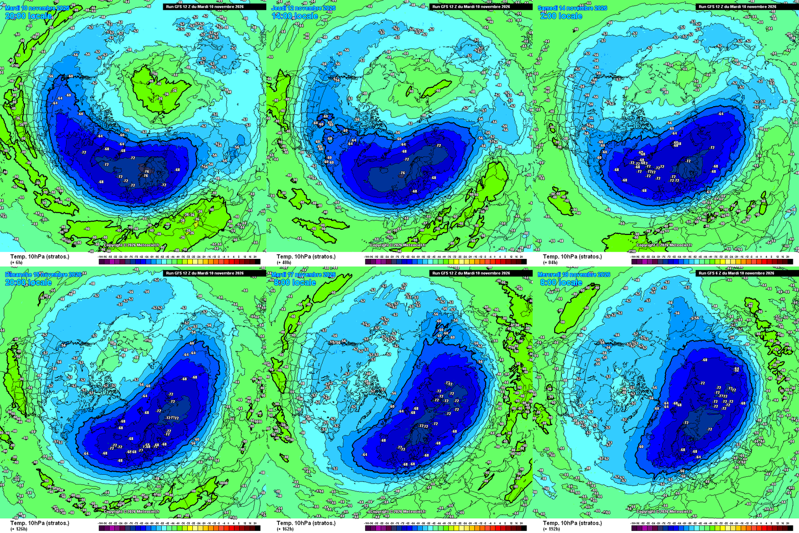
Being an episode of stratospheric warming is very early this year one has to wonder how often the warming would occur into this winter?
While an early Stratospheric warming does not suggest a busy "Strat" winter season; it's interesting to delve into research on the topic.
Duration of Impact: Instead of signaling more warmings to come, a single November SSW tends to have a prolonged ripple effect on surface weather patterns that can last for weeks to a couple of months, potentially influencing late-fall and winter cold-air outbreaks rather than multiplying the number of stratospheric events. [1, 2, 3]. Very Interesting - More on the subject including what exactly is a stratopheric warming can be found at:
1- https://x.com/BenNollWeather/status/1991136881837478343 2 - https://www.yahoo.com/news/weather-news/article/the-polar-vortex-is-weakening-unusually-early-heres-what-that-could-mean-for-the-weather-172644197.html 3 - https://www.yahoo.com/news/weather-news/article/the-polar-vortex-is-weakening-unusually-early-heres-what-that-could-mean-for-the-weather-172644197.html 4 - https://csl.noaa.gov/groups/csl8/sswcompendium/majorevents.html.
Ok so next; let's take a look at the moderate to very strong El Ninos. The majority of El Ninos listed for our analogues this go around are strong to very strong (or super El Ninos). I've come up with 15 years with the majority mild to very mild as seen in the Analogues below. The strongest El Nino ever recorded and closest to this years El Nino was w a y back in 1877-78. Eight seasons were above normal, Five were normal and Just two were colder and those were during the colder winters in the late 1800's.
TEMPERATURES
As would be expected; I'm forecasting a milder than normal winter ( +1 1/2 to +3 1/2 degrees ) with the emphasis on dominant mild weather patterns. However with the possibilities of stratospheric warmings and thus; weakening of the Polar Vortex (and thus expanding the Polar/Arctic jet interjection); I do expect some Polar/Arctic air outbreaks to make it into Southeast Lower Michigan. This leads to early indications that December may not be as mild as generally happens taking into account this discussion. This conflicts with the warmest Decembers during El Ninos in our analogues and has to be watched; what also has to be watched for the prevent the Storm Track for rain/snow. Just because lighter snows were predominant in these winters doesn't mean we could not get set up for a couple of notable storms. Any aggressive Polar/Arctic jet interacting with the strong Pacific jet in the right places)
SNOWFALL/ PRECIPITATION
Snowfall for this winter is literary "up in the air"! Overwhelming; the analogues snow a light snowfall season with an average snowfall just less than 30" at 28.2" (norm 45.0") - a paltry season if you're a bull for snow! There is one caveat though; there is a small subsection of analogues that paints near normal snow with average or normal temperatures Three of the seasons showed snowfall 43.0" - 45.0" while 11 of the winters had that below normal snow out of the 14 snow samples (1877-78 N/A). There were no above normal snows - a rare entity indeed.
|
|
|
L |
|
|
|
|
|
|
|
|
|
|
|
DETROIT |
T |
E |
M |
P |
S |
|
P |
C |
P |
N |
|
|
SEASON |
DEC |
JAN |
FEB |
WNT AVE |
WINTER |
NAO/SC |
SEASON |
DEC-FEB |
WINTER |
PDO/QBO |
|
|
1877-78 |
38.1 |
27.3 |
29.2 |
31.5 |
1 |
N+/SC-- |
1877-78 |
7.11 |
1 |
PDO+/- |
|
|
1881-82 |
40.6 |
31.0 |
39.5 |
37.0 |
2 |
N++/SC+ |
1881-82 |
8.06 |
2 |
PDO--/- |
|
A |
1888-89 |
31.4 |
29.8 |
19.4 |
26.9 |
1 |
N/SC-- |
1888-89 |
3.43 |
1 |
PDO+/- |
|
N |
1896-97 |
30.3 |
23.0 |
27.5 |
26.9 |
2 |
N+/SC++ |
1896-97 |
3.72 |
2 |
PDO/- |
|
A |
1905-06 |
32.0 |
33.6 |
25.6 |
30.4 |
3 |
N+/SC++ |
1905-06 |
4.49 |
3 |
PDO+/- |
|
L |
1940-41 |
32.1 |
26.3 |
25.3 |
27.9 |
1 |
N-/SC-- |
1940-41 |
4.99 |
4 |
PDO++/- |
|
O |
1957-58 |
34.1 |
26.6 |
22.8 |
27.8 |
2 |
N/N-/SC+ |
1957-58 |
6.07 |
2 |
PDO+/W- |
|
G |
1965-66 |
35.9 |
21.4 |
28.3 |
28.5 |
3 |
N/N-/SC+ |
1965-66 |
5.99 |
3 |
PDO-/E+ |
|
U |
1972-73 |
29.4 |
28.8 |
25.3 |
27.8 |
4 |
N/SC- |
1972-73 |
5.84 |
4 |
PDO-/E+/- |
|
E |
1982-83 |
37.3 |
28.7 |
31.6 |
32.5 |
4 |
N++/SC++ |
1982-83 |
5.02 |
5 |
PDO+/W |
|
S |
1991-92 |
32.1 |
28.3 |
30.8 |
30.4 |
5 |
N+/SC- |
1991-92 |
5.23 |
6 |
PDO/E |
|
|
1997-98 |
32.3 |
32.8 |
36.7 |
33.9 |
6 |
N/SC-- |
1997-98 |
8.27 |
2 |
PDO+/N |
|
|
2009-10 |
29.2 |
25.1 |
27.9 |
27.4 |
5 |
NAO-/SC-- |
2009-10 |
5.56 |
7 |
PDO/E |
|
S |
2015-16 |
41.1 |
28.1 |
31.2 |
33.5 |
7 |
N+/SC- |
2015-16 |
6.37 |
5 |
PDO+W- |
|
T |
2023-24 |
40.1 |
27.5 |
37.1 |
34.9 |
8 |
N/SC++ |
2023-24 |
7.76 |
3 |
PDO-/E+ |
|
R |
Ave |
34.4 |
27.9 |
29.2 |
30.5 |
|
|
Ave |
5.86 |
2026-27 |
PDO-/W/+ |
|
O |
NORM 30Y |
31.3 |
25.6 |
28.0 |
28.3 |
100YR - |
26.7 |
Norm |
6.56 |
|
W/W+ |
|
N |
Dep |
3.1 |
2.3 |
1.2 |
2.2 |
|
|
Dep |
-0.70 |
|
|
|
G |
|
|
|
|
-1.2 |
|
|
|
|
|
|
|
|
DETROIT |
S |
N |
O |
W |
F |
A |
L |
L |
|
Oct |
|
N |
SEASON |
OCT |
NOV |
DEC |
JAN |
FEB |
MAR |
APR |
SEA TOT |
SEASON |
Sib snow |
|
I |
1877-78 |
- |
- |
- |
- |
- |
- |
- |
- |
- |
- |
|
N |
1881-82 |
0 |
0.2 |
3.4 |
3.7 |
2.1 |
3.8 |
T |
13.2 |
1 |
* |
|
O |
1888-89 |
T |
0.9 |
1.2 |
9.8 |
5.3 |
4.1 |
1.9 |
23.2 |
2 |
* |
|
|
1896-97 |
T |
T |
7.4 |
8.7 |
8.2 |
10.4 |
T |
34.7 |
3 |
* |
|
W |
1905-06 |
0 |
0.3 |
4.8 |
7.3 |
1.6 |
14.4 |
1.0/T |
29.4 |
4 |
* |
|
I |
1940-41 |
0 |
0.1 |
4.3 |
6.4 |
4.2 |
2.8 |
0 |
26.8 |
5 |
* |
|
N |
1957-58 |
T |
1.7 |
5.1 |
3.4 |
4.1 |
3.5 |
2.1 |
18.0 |
6 |
* |
|
T |
1965-66 |
T |
0.2 |
1.6 |
6.7 |
2.5 |
2.6 |
1.8 |
15.4 |
7 |
* |
|
E |
1972-73 |
T |
7.1 |
12.5 |
2.4 |
12.8 |
10.1 |
0.1/T |
45.0 |
1 |
A |
|
R |
1982-83 |
T |
1.8 |
1.4 |
1.5 |
4.3 |
7.6 |
3.4 |
20.0 |
8 |
A |
|
S |
1991-92 |
T |
2.2 |
8.6 |
18.4 |
2.4 |
11.7 |
0.2 |
43.5 |
2 |
A |
|
|
1997-98 |
0.1 |
4.6 |
6.0 |
8.3 |
T |
4.4 |
0 |
23.4 |
9 |
A |
|
|
2009-10 |
0 |
0 |
7.8 |
8.9 |
27.0 |
T |
T |
43.7 |
3 |
A |
|
2 |
2015-16 |
T |
6.2 |
1.3 |
8.4 |
10.7 |
7.4 |
1.3/T |
35.3 |
10 |
A |
|
0 |
2023-24 |
0.2 |
2.2 |
0.1 |
17.0 |
3.1 |
0.9 |
T |
23.5 |
11 |
A |
|
2 |
Ave |
T |
2 |
4.7 |
7.9 |
6.3 |
6.0 |
0.8 |
28.2 |
|
A |
|
6 |
30y Norm |
0 |
1.9 |
8.9 |
14.0 |
12.5 |
6.2 |
1.5 |
45.0 |
|
|
|
|
Dep |
0 |
-0.1 |
-4.2 |
-6.1 |
-6.2 |
-0.2 |
-0.7 |
-16.8 |
|
Sib Snow |
|
| |
|
|
|
|
|
7 |
|
|
45 |
ther |
* N/A |
|
|
Color |
Temps |
Degrees |
|
Rain |
Inches |
|
Snow |
Inches |
|
|
|
2 |
Legend: |
Below |
1.0> |
|
Below |
1.00> |
|
Below |
<5.0 |
n |
|
|
7 |
|
Normal |
0.0-1.0 |
|
Normal |
0.00-1.00 |
|
Normal |
>-5.0<5.0 |
|
|
|
|
|
Above |
1.0> |
|
Above |
1.00> |
|
Above |
>5.0 |
|
|
|
|
|
|
|
|
|
|
|
|
|
|
|
More on the evolving atmosphere, storm tracks and model outlook for this cold season along with comparisons to Winter Outlook Analogues by mid December.


No comments:
Post a Comment