The Pre-Christmas storm is still expected along and back behind the the Arctic front moving through overnight into Friday. Warmer air ahead of the storm center will allow more rain to fall and less snow on the back-side of the system. Majority of models bring the change over around midnight Thursday and create icy road conditions and strong winds Friday morning into Friday.
What's still threatening with the system is the strong, frigid winds accompanying the backside of the storm. Wind gusts will be strongest on Friday and Friday night; possibly reaching the 40 - 50 mph range. Major concern will still be flash freezing on the roads creating hazardous driving conditions along with local power outages, certainly a risk.
Yesterday I stated;
I've posted parts of the the GFS and Euro /12z/ just to give an idea of the range of weather conditions projected at this time /Wed-2pm/. At this time I'd side closer to the European expectations for weather conditions and local snow amounts with GFS greater than and also less than the European.Variability in intensity, location, movement resulting in duration and precipitation (snow ratios) is causing a variation in model output.
This is the case with guidance; I still prefer the European and snowfall totals have come down a notch for a few reasons. The system is moving faster; a subtle dry-slot behind the occlusion is a risk and more rain is expected ahead of the low/front. Even lower amounts of snow are showing up on a few models in the metro Detroit area /1-2"/; we'll see if this materializes. The range and intensities of this system for days has been a nightmare on the models.
Checking latest preferred Euro guidance:
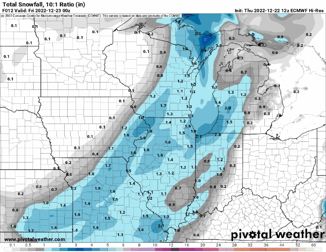
Generally 2-4" of snow is expected around the Metro Detroit area with 4-6" over the western/highland regions and downwind of lake Huron. Some pockets of higher snow amounts are possible; especially with Lake Effect snow into Saturday.
Making weather fun while we all learn,
No comments:
Post a Comment