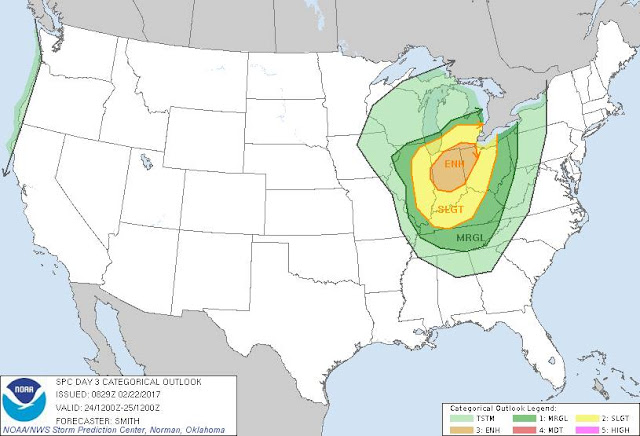
. . .SEVERE WEATHER UPDATE - 2/24/17 AT 12 NOON FRIDAY . . .
 ...THERE IS AN ENHANCED RISK OF SEVERE THUNDERSTORMS OVER PARTS OF
    SOUTHERN LOWER MI...EASTERN IN...WESTERN AND CENTRAL OH...AND
    NORTHERN KY...
 ...SUMMARY...
    Severe thunderstorms are forecast to affect areas from Lower
    Michigan southward to Tennessee, mainly this afternoon through
    tonight.  The primary threat appears to be damaging wind, but some
    hail and a few tornadoes will also be possible.
 ...Southern Lower MI/Northern IN...
    Only minor changes have been made to the ongoing forecast.  Water
    vapor loops show a large upper trough over the Central Plains, while
    a deep surface low tracks northeastward across northern IL.  The
    initial severe concern will be ahead of the surface low and into the
    vicinity of the warm front lifting northward into MI.  Relatively
    strong heating and low level moisture advection will result in
    MLCAPE values around 1000 J/kg along and south of the boundary.  12z
    model solutions are consistent in developing scattered thunderstorms
    along this corridor this afternoon and early evening.  Forecast
    soundings suggest a favorable vertical shear profile for discrete
    supercells capable of large hail and damaging winds.  This portion
    of the outlook area holds the greatest concern for supercell
    tornadoes later today.
Previous 2/22/17 Write-Up and Update....
A strong spring-like system will be surging through the Great Lakes and Upper Ohio Valley Friday into Saturday. The unseasonably warm, spring-like temperatures that have affected Southeast Lower Michigan for the past several days will be rudely pushed east of the later Friday night and Saturday.
Ahead of the front; this clash of the spring-like and winter air masses will also bring the potential for strong damaging winds as showers and thunderstorms barrel through the area Friday afternoon into early Saturday morning. This storm system, more typical of a classic late March or April storm system, will also bring the risk of a rather unusual event of severe weather for February.
The set-up Friday night based on Latest NAM, 00Z - 022317
The deep low will occlude and move through Lower Michigan Friday afternoon into the first half of Friday night. Heavy to very heavy showers and scattered thunderstorms can be expected to charge ahead of the cold front and along the warm front. Very strong gusty winds will accompany the activity with gusts in excess of 50 mph are likely in the worst of the storms.


All severe weather parameters (and some not shown) paint the best instability, bulk shear, lapse rates and unusual (for February), surface based CAPE over Southern and Southeast Lower Michigan. The nose of an 80knot Bulk Shear coming into the Southern Great Lakes, certainly draws attention to the potential of realized damaging winds any heavy shower or storm could bring down. At the very least, the idea of a "thunder-less" line of heavy showers with potential severe winds would also be a threat with this system.
A potential for short-fused severe weather event is in the wings from Friday evening into the first half of the night till about 2am EST Saturday morning at this early juncture. Strong low pressure system and attending warm and cold fronts will be barrelling across Southern Lower Michigan at that time.
From the Storm Prediction Center
...Southern Great Lakes and Ohio Valley...
Low-level moisture is forecast to slowly increase on strong
southerly flow with boundary-layer dewpoints forecast to range 52-58 degrees F. Although cloud cover will retard strong surface heating, cooling mid-level temperatures to around -19 degrees C will contribute to weak buoyancy (ranging from 250-1000 J/kg MUCAPE) within the northward expanding warm sector during the day. As strong forcing for ascent (DCVA) approaches and overspreads the western parts of the area, a band of thunderstorms will likely develop and intensify. Strong effective shear around 50 kt will act to organize updrafts and strengthening 700-mb flow to the 55-60 kt range will contribute to cold pool's organization and upscale growth. Downward momentum transport via damaging winds are the predominant severe risk. However, some forecast soundings show relatively moist low levels with strong 0-1 km shear in excess of 25-30 kt. A tornado risk may develop with the maturing squall line and/or pre-frontal supercell(s) that eventually merges with the line. A gradual weakening in buoyancy by the early to mid evening into the overnight will likely lead to a lessening in the damaging-wind risk as storms rapidly move east and northeastward after dark.
Making weather fun while we all learn,
Bill Deedler -SEMI_WeatherHistorian


No comments:
Post a Comment