It seems we just got started with summer and here it is, fall again. And, with the cool July this past summer, it even feels more that way this fall.
Temperatures
I look for temperatures to average around normal...or within two degrees of the normal. In my research, the normal range (or one standard mean deviation) for an average fall is in fact, about two degrees. At Detroit the 137 year mean now is 52.2... while the 30 year normal is a bit higher at 52.8. (see more, below).
Precipitation
The busy pattern of the summer looks like it will continue into the fall with normal to above normal rainfalls (see more below).
Fall is cited for its wild swings in temperatures and this fall certainly should be no different as impressive upper lows in Canada dive south and southeast into the U.S. The aggressiveness of this overall, now common-place pattern shows little change in the last year. Both upper air and analogues also do suggest typical to strong cold outbreaks along with some contrasting upper ridging to bring classic Indian Summer weather. Generally with stronger El Ninos, the risk of not having common Indian summers rises as the jet remains stronger across the south and less ridging/blocking is likely.
Pacific Water's in Transition
The ENSO state continues to "ebb and flow" toward an El Nino state. The problem is just how much of an El Nino state will be recognized? Earlier this year; many dynamic and statistical models were gun-ho on at least a moderate El Nino but have since backed-off on this more aggressive state. This will definitely have an effect on the upcoming autumn and especially winter. Weak El Nino's can bring - or aid - in a variety of scenarios for the upcoming seasons.
Here is the CFS projections for the upcoming El Nino and its when and where positions into th winter. Notice the projections move from a general Pacific basin El Nino to an east base. This too, if accurate, would have repercussions on our winter.

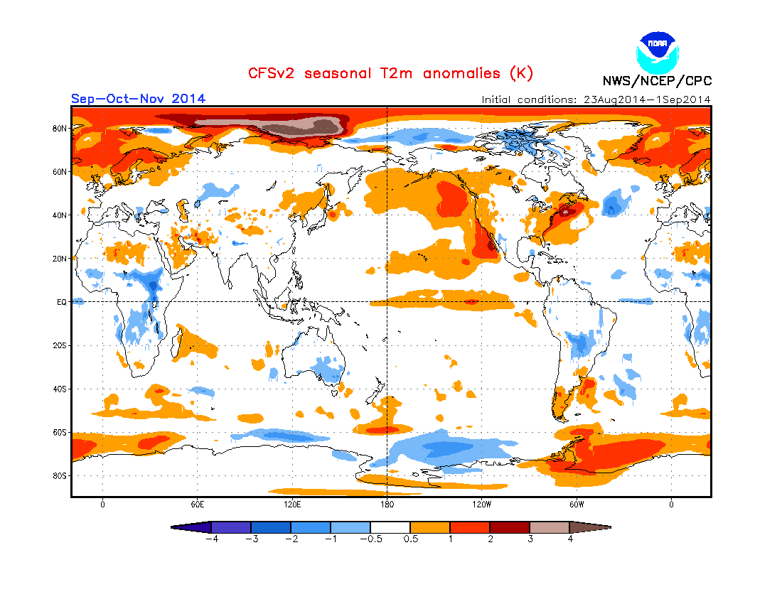
CFS Projected Temperatures
Pacific ENSO Sea Surface Temperature Projections
Latest run of the assortment of models project the following;

The most likely scenario realistically is a range (tan shading) between 0.6 and 1.1 which would place it as a weak El Nino. Therefore, the upcoming fall and winter while influenced somewhat by the El Nino state, will not be ruled by it. Of course, this opens the door to a whole realm of possibilities as to the outcome of the upcoming winter, but first lets take a look at one season at a time, autumn.
Upper/Surface Patterns
Oscillations of upper and related surface patterns with a preference toward troughing and cooler than normal weather should be balanced out somewhat, leaving us with an average or normal fall with notable sharply contrasting patterns. That being said; it will be prudent to keep a watch on evolving phases of the NAO and AO...and once again and just as important, like the last several seasons; the EPO. While there is no projection of the EPO that I'm aware of; there is for the NAO/AO.
The latest experimental projections of these oscillations are below, from Kyle MacRitchie, a Ph.D. candidate in Atmospheric Science at the University at Albany

Projections for North Atlantic Oscillation /NAO/ (above) this fall are fairly tame with of course in time, wider variations in ensemble projected data from October on into the opening of December.
Investigating the encompassed Arctic Oscillation /AO/ (below) proves to be more interesting. More negatively biased data output rules in the Arctic Oscillation during the autumn months. In addition; more wider swings in the ensemble package.

Autumn 2014 Analogues

Temperatures
Autumn analogues continue the same trends seen in the summer analogues with the majority /5/ of the seasons containing normal temperatures; with two below normal and two above. The problem is the averages are the mean of the extremes, in some years! Look for some notable contrasts during the falls. October is highlighted with above normal temperatures but we know how monthly trends have been working recently. The actual temperature trends have been reliable but not timing. All I can gather from this is that warmer than normal temperatures are likely, likely creating some Indian Summer weather mid fall.
Preciptation
Rainfall is very similar to summers analogues with a wild variety of outcomes with a tilt toward normal to below. I feel this is a bit too low given the trend we are in and likelihood of busy frontal activity. I look for normal to above rainfall across the region.
While the chances of a frost/freeze occurring near or before the average dates were good, the dates when the first snow flakes (trace) flew were more variable. October historically sees at least a trace of snow by the end of the month.
Get out and enjoy the good fall weather!
Important Dates
Autumn arrives: Mon - Sep 22nd @ 10:29PM
Harvest Moon; Mon - Tue Sep 8-9th
Hunter's Moon: Wed - Oct 8th
Halloween: Fri - Oct 31st
Thanksgiving Thu - Nov 27th
Making weather fun while we all learn,
Bill Deedler -SEMI_WeatherHistorian
Bill Deedler -SEMI_WeatherHistorian
What do you predict for winter? A lot of rumors circulating online ....
ReplyDeleteMy Winter Outlook will be out in the late October - early November time frame.
ReplyDeleteHi Bill
ReplyDeleteYour looking good
ReplyDeleteThanks! This fall has certainly been busy and a roller coaster. September had everything temperature-wise...from the 90s to the 30s and was wet from a busy storm track - bringing bouts of severe weather to boot.
Delete