Analogues Point to a Cold January Likely with Coldest Air of the Season Thus Far Due Early Next Week With Some Moderation Late
After the cold below normal November; December followed November's cue unfolding as expected with mainly colder than average weather and larger departures below normal. All of Southeast Lower Michigan experienced below normal temperatures on average in December. Even with over a third of the month's days /13/ having above normal temperatures; it was the below normal temperature departure days that sunk December's average temperature and subsequent departures. In the end; December averaged 2 1/2 - 4 1/2 degrees below normal across Southeast Lower Michigan with Detroit @ 26.8/-3.3; Flint @ 25.0/-2.5 and Saginaw @ 22.8/-4.5. Snowfall got off to a good start for the first real month of winter with Detroit @ 15.5"/ +5.8"; Flint @ 16.9"/+ 5.1 and Saginaw 18.9"/+ 9.9".


All inclusive analogue data projected a below normal December on average along with the majority of Decembers more than a degree below average. Researching the years of below average analogue December data, the recent pattern of the autumn including local data and upper wind pattern and past November's analogue data; it was decided to go for a cold December along with a cold general winter in the Winter Outlook.
Reviewing December's temperature data presented by this winter season's analogue's along with December's actual data outcome presented the following:
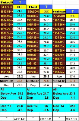
Below normal analogue guidance for December dropped the average temperatures for December some 3 - 4 degrees below normal when using the majority (below) of three categories (above, normal, below) normal. December's predominant below normal data in the chart below shows just how close the below normal average (more than a degree and thus, considered below normal for our study - 8 /Detroit/, 7/Flint/, 5/Saginaw/) temperatures verified. All three cities came within a degree or less of the mean for below normal Decembers. In addition; those individual analogue December's marked with an asterisk* were within a degree or less of December 2013's average. It also should be noted while Detroit came in a degree warmer than below normal analogues; those analogues years included a much less (if at all) heat island. Therefore; one could assume this past December's average temperature would fall closer to the analogue projected 25.8
temperature if the heat island affect was subtracted or diminished.
In January's analogue guidance; below normal temperature guidance continued to rule but like last month, with some notable moderation breaks. In fact; the pattern this season does suggest the likelihood of a classic January thaw as progressive Pacific upper air jet streams also push inland and transverse the country. Meanwhile; the Polar and Arctic air over Canada will periodically get recharged during the depths of this winter.
Frigid Blast
The coldest air of the season thus far is slated to dive across the country later this weekend behind another storm system projected to develop ahead of the Arctic plunge. This storm is expected to move from the Arkansas region northeast into Ohio on it's way to New York state Sunday into Monday. More significant snow is likely to the north of this storm late in the weekend as bitter cold air follows in its wake at the opening of the first full week of January. Below zero temperature lows are expected to be widespread early next week; bringing the coldest air of the season and since January 2009. One might remember during that mid-month January period; Detroit's Flint's and Saginaw's temperatures fell below zero four or five days (depending on location) in a row from the 13th through the 17th. Detroit's coldest temperature cratered to -15 on the 16th and not to be out-done, Flint's fell to -19 on the 14th while Saginaw bottomed at -10. Expect some moderation in temperatures mid to late week.
An update on the projected storm and frigid air to follow will be sent this weekend then up next; looking at the best performing analogues thus far and January's projections.
Making weather fun while we all learn,
Bill Deedler -SEMI_WeatherHistorian
Bill Deedler -SEMI_WeatherHistorian
No comments:
Post a Comment