9/24
Another cold night leaves temperatures solidly in the 30s along with areas of frost and isolated areas of freezing temperatures. Readings fell mainly into the mid 30s with lowest temperatures around 30 and highest around 40. While temperatures fell close to records, no record lows were set at Detroit, Flint nor Saginaw. The closest breach was Flint with a low of 34 and record of 31/1989. Detroit fell to 37 with a record of 33/1989 and Saginaw fell only to 38 with a record of 30/1950.
Repeating;
Monday morning should be the last in this episode of cold weather for the time-being as the rest of the week looks milder. While temperatures will rebound somewhat during the week; overall readings will still range from cooler than normal to near normal. Normal highs across Southeast Michigan during the last week of September average in the mid 60s to near 70; while lows fall into the mid 40s to near 50.
000
ASUS63 KDTX 241534
RTPDTX
MORNING TEMPERATURE AND PRECIPITATION SUMMARY
NATIONAL WEATHER SERVICE DETROIT/PONTIAC MI
1134 AM EDT MON SEP 24 2012

VALUES REPRESENT YESTERDAY`S HIGHS....LOW OVER THE LAST 12 HOURS
AND PRECIPITATION OVER THE LAST 24 HOURS ENDING AT 8 AM EDT


.BR DTX  0924  ES DH00/TAIRZX/DH07/TAIRZP/TA/PPDRZZ


:SOUTHEAST MICHIGAN -- TEMPERATURE AND PRECIPITATION STATIONS
:.......................................................
:       STATION              MAX / MIN  / 8 AM  / 24-HR
:        NAME                TEMP/ TEMP / TEMP  / PRECIP
:.......................................................
WHKM4: NWS WHITE LAKE      :   54 /  33  /  38  / 0.01
ARBM4: ANN ARBOR           :   57 /  37  /  38  /    T
ADG  : ADRIAN AIRPORT      :   58 /  36  /  37  / 0.00
BAX  :*BAD AXE AIRPORT     :   54 /  33  /  39  /
CFS  :*CARO AIRPORT-TUSCOLA:   55 /  32  /  36  /
DET  : DETROIT CITY AIRPORT:   58 /  39  /  41  / 0.00
DTW  : DETROIT METRO ARPT  :   59 /  37  /  39  / 0.00
FNT  : FLINT BISHOP AIRPORT:   57 /  34  /  41  / 0.02
ONZ  :*GROSSE ILE AIRPORT  :   59 /  43  /  46  /
OZW  :*HOWELL AIRPORT      :   57 /  37  /  41  /
DUH  :*LAMBERTVILLE AIRPORT:   60 /  36  /  39  /
D95  :*LAPEER DUPONT AIRPRT:   54 /  32  /  39  /
IKW  :*MIDLAND AIRPORT     :   55 /  30  /  36  /
TTF  :*MONROE AIRPORT      :   57 /  36  /  37  /
RNP  :*OWOSSO AIRPORT      :   58 /  39  /  45  /
PTK  : PONTIAC AIRPORT     :   56 /  37  /  38  / 0.00
P58  : PORT HOPE           :   56 /  40  /  41  / 0.02
PHN  :*PORT HURON AIRPORT  :   54 /  30  /  36  /
MBS  : SAGINAW - TRI-CITIES:   58 /  38  /  39  / 0.01
HYX  :*SAGINAW-HARRY BROWNE:   57 /  37  /  41  /
VLL  :*OAKLAND/TROY AIRPORT:   58 /  40  /  42  /
YIP  : YPSILANTI WILLOW RUN:   60 /  37  /  39  / 0.01
.END


*THE TEMPERATURE DATA FOR THESE SITES ABOVE REPRESENT THE HIGHEST AND
 LOWEST TEMPERATURES THAT WERE REPORTED ON THE METAR OBSERVATIONS
 THAT TRANSMIT THREE TIMES AN HOUR AND MAY NOT REPRESENT THE ACTUAL
 HIGH OR LOW FOR THAT SITE. THESE SITES DO NOT MEASURE
 PRECIPITATION.
.....................................................................


THE FOLLOWING COOPERATIVE OBSERVER SITES REPORT FROM MIDNIGHT TO
MIDNIGHT THE PREVIOUS DAY.


.BR DTX  0924  ES DH07/TAIRZX/TAIRZN/TA/PPDRZZ


:SOUTHEAST MICHIGAN -- TEMPERATURE AND PRECIPITATION STATIONS
:.......................................................
:       STATION               MAX / MIN  / 12 AM /24-HR
:        NAME                 TEMP/ TEMP / TEMP  /PRECIP
:.......................................................
ARNM4: ADRIAN              :   57 /  39  /  40  / 0.00
MILM4: MILFORD - GM GROUNDS:   57 /  40  /  41  / 0.03
MDLM4: MIDLAND             :   57 /  39  /  42  /    T
MTC  : MT CLEMENS SELFRIDGE:    M /   M  /  41  /    M
SGNM4: SAGINAW 5W          :   56 /  38  /  39  / 0.01
.....................................................................


COOPERATIVE OBSERVATIONS VALUES ARE FOR APPROXIMATELY THE PREVIOUS 24
HOURS FROM YESTERDAYS OBSERVATION TIME TO TODAY`S OBSERVATION TIME.


.BR DTX  0924  ES DH07/TAIRZX/TAIRZN/TA/PPDRZZ


:SOUTHEAST MICHIGAN -- TEMPERATURE AND PRECIPITATION STATIONS
:.........................................................
:       STATION            OB   /MAX / MIN  / OB   /24-HR
:        NAME              TIME /TEMP/ TEMP / TEMP /PRECIP
:.........................................................
: ***MIDLAND COUNTY***


: ***BAY COUNTY***
AUBM4:  AUBURN            :0630/   51 /  33  /  35  / 0.00


: ***HURON COUNTY***
BDAM4:  BAD AXE           :0700/   56 /  37  /  37  / 0.02
FLNM4:  FILION 5NNW       :0620/   54 /  37  /  37  / 0.01
POAM4:  PORT AUSTIN       :0740/   55 /  38  /  39  / 0.10
PHPM4:  PORT HOPE         :0800/   55 /  38  /  42  / 0.01


: ***SAGINAW COUNTY***
CHSM4:  CHESANING         :0730/      /      /      /0.01
MERM4:  MERRIL 2E         :0800/   57 /  35  /  39  /    T
SAGM4:  SAGINAW           :0800/   59 /  37  /  37  /    T


: ***TUSCOLA COUNTY***
CARM4:  CARO              :0730/   55 /  37  /  38  / 0.03
VSSM4:  VASSAR            :0700/   58 /  31  /  32  /    T


: ***SANILAC COUNTY***
LEXM4:  LEXINGTON         :0745/   57 /  37  /  39  / 0.00
MRLM4:  MARLETTE          :0700/   54 /  37  /  38  / 0.00


: ***SHIAWASSEE COUNTY***
CORM4:  CORUNNA 2NE       :0600/   59 /  38  /  38  / 0.02
DRNM4:  DURAND            :0800/   57 /  38  /  42  / 0.02
OWSM4:  OWOSSO            :0700/   57 /  36  /  39  / 0.07


: ***GENESEE COUNTY***
BUNM4:  BURTON 4N         :0700/   59 /  33  /  34  / 0.03
FLTM4:  FLINT  7W         :0800/   56 /  36  /  40  /    T
GODM4:  GOODRICH          :0730/   57 /  36  /  38  / 0.03


: ***LAPEER COUNTY***
LPEM4:  LAPEER 2W         :0910/   57 /  36  /  46  /    T
LPRM4:  LAPEER            :0730/   55 /  36  /  39  / 0.03


: ***ST. CLAIR COUNTY***
AGCM4:  ALGONAC           :M   /    M /   M  /  43  / 0.00
YALM4:  YALE              :0655/   58 /  37  /  37  / 0.00


: ***LIVINGSTON COUNTY***
HELM4:  HELL              :1015/   57 /  35  /  53  / 0.02
HOWM4:  HOWELL            :0745/   58 /  32  /  34  / 0.00


: ***OAKLAND COUNTY***
FARM4:  FARMINGTON        :0730/   58 /  35  /  35  / 0.05
PONM4:  PONTIAC           :0808/   55 /  39  /  43  / 0.00
WSBM4:  WEST BLOOMFIELD   :0730/      /       /     / 0.00


: ***MACOMB COUNTY***
RICM4:  RICHMOND 4NNW     :0815/   58 /  33  /  36  / 0.00


: ***WASHTENAW COUNTY***
AASM4: ANN ARBOR-SOUTHEAST:0730/   58 /  34  /  35  / 0.01
AAWM4:  ANN ARBOR 1W      :0830/   58 /  38  /  48  / 0.00
CHLM4:  CHELSEA           :0926/   57 /  34  /  47  /    T
MCHM4:  MANCHESTER        :0638/   59 /  35  /  35  /    T
SLNM4:  SALINE 4SW        :0800/   60 /  31  /  34  / 0.00
SALM4:  SALINE            :0800/   53 /  30  /  32  / 0.00


: ***WAYNE COUNTY***
DBNM4:  DEARBORN          :0500/   60 /  40  /  40  / 0.00
GPFM4:  GROSSE PTE FARMS  :0800/   58 /  39  /  42  / 0.00
WYTM4:  WYANDOTTE         :0800/      /       /     /    T


: ***LENAWEE COUNTY***
BLIM4:  BLISSFIELD 1SW    :0630/   58 /  33  /  34  /    T
MRIM4:  MORENCI           :0730/   60 /  33  /  34  / 0.00
TECM4:  TECUMSEH          :0630/   60 /  35  /  37  / 0.02
TIPM4:  TIPTON 2WNW       :0800/   60 /  34  /  35  / 0.01


: ***MONROE COUNTY***
DNDM4:  DUNDEE            :0720/   59 /  36  /  36  / 0.04
MLIM4:  MILAN             :0815/   57 /  35  /  37  / 0.03
MNRM4:  MONROE            :0730/   59 /  34  /  34  / 0.00
NWPM4:  NEWPORT 4SSE      :0600/   61 /  37  /  39  / 0.00
---------------------------------------------------------------------------------------------------------
9/23
The second wave of unseasonably cold air initially mentioned in my write up way back on 9/13 is now over the region and does pose the risk of some frost and freezing temperatures across Southeast Lower Michigan. This is the second and more potent of the two cold air masses to move over the region this past week and is now settling over the region. The air mass does have the capability of producing areas of frost and freezing temperatures; especially in the advent of clearing skies and lighter winds. Record lows Monday morning are genrally in the lower 30s; with 33 at Detroit, 31 at Flint and 30 at Saginaw. While the Detroit area, including Metro Airport, appear safe from breaking the record low of 33; regions away from the city into rural areas of Southeast Michigan do run the risk of temperatures falling as low from around 30 to the mid 30s (which includes Flint and Saginaw). On the warmer side of things; areas under patchy clouds, near and/or in cities, lakes and woods have the least likely risk of frost or freeze overnight.
Monday morning should be the last in this episode of cold weather for the time-being as the rest of the week looks milder. While temperatures will rebound somewhat during the week; overall readings will still range from cooler than normal to near normal. Normal highs across Southeast Michigan during the last week of September average in the mid 60s to near 70; while lows fall into the mid 40s to near 50.
Gardeners, nursery and landscape owners including other outside interests should be aware of the risk of a frost or freeze on tender, susseptible plants toight. Watering plants late this eveing or overnight may help in keeping warmer temperatures near ground level and cut down the risk of damage should frost or freeze develop in your area.
Making weather fun while we all learn,
Bill Deedler -SEMI_WeatherHistorian
-------------------------------------------------------------------------------------------------------------------------
Update 9/19
It was a cold morning across Southeast Lower Michigan with some areas coming within a degree or two from their records. Detroit Metro Airport fell to 39 /record 38/ while the rest of the region ranged from the mid 30s to mid 40s. However; Midland Airport did fall to 31 degrees for the coldest spot across the region.
MORNING TEMPERATURE AND PRECIPITATION SUMMARY
NATIONAL WEATHER SERVICE DETROIT/PONTIAC MI
923 AM EDT WED SEP 19 2012

VALUES REPRESENT YESTERDAY`S HIGHS....LOW OVER THE LAST 12 HOURS
AND PRECIPITATION OVER THE LAST 24 HOURS ENDING AT 8 AM EDT


.BR DTX  0919  ES DH00/TAIRZX/DH07/TAIRZP/TA/PPDRZZ


:SOUTHEAST MICHIGAN -- TEMPERATURE AND PRECIPITATION STATIONS
:.......................................................
:       STATION              MAX / MIN  / 8 AM  / 24-HR
:        NAME                TEMP/ TEMP / TEMP  / PRECIP
:.......................................................
WHKM4: NWS WHITE LAKE      :   61 /  34  /  37  /    T
ARBM4: ANN ARBOR           :   65 /  42  /  42  / 0.08
ADG  : ADRIAN AIRPORT      :   65 /  36  /  39  / 0.12
BAX  :*BAD AXE AIRPORT     :   63 /  36  /  38  /
CFS  :*CARO AIRPORT-TUSCOLA:   62 /  33  /  35  /
DET  : DETROIT CITY AIRPORT:   66 /  41  /  43  / 0.06
DTW  : DETROIT METRO ARPT  :   67 /  39  /  41  / 0.06
FNT  : FLINT BISHOP AIRPORT:   64 /  35  /  40  / 0.03
ONZ  :*GROSSE ILE AIRPORT  :   68 /  45  /  46  /
OZW  :*HOWELL AIRPORT      :   64 /  40  /  43  /
DUH  :*LAMBERTVILLE AIRPORT:   66 /  38  /  42  /
D95  :*LAPEER DUPONT AIRPRT:   64 /  36  /  38  /
IKW  :*MIDLAND AIRPORT     :   62 /  31  /  33  /
TTF  :*MONROE AIRPORT      :   66 /  37  /  41  /
RNP  :*OWOSSO AIRPORT      :   65 /  38  /  44  /
PTK  : PONTIAC AIRPORT     :   63 /  40  /  42  / 0.00
P58  : PORT HOPE           :   65 /  42  /  43  / 0.01
PHN  :*PORT HURON AIRPORT  :   64 /  36  /  37  /
MBS  : SAGINAW - TRI-CITIES:   64 /  37  /  38  / 0.03
HYX  :*SAGINAW-HARRY BROWNE:   64 /  37  /  41  /
VLL  :*OAKLAND/TROY AIRPORT:   66 /  43  /  44  /
YIP  : YPSILANTI WILLOW RUN:   68 /  38  /  40  / 0.05
.END


*THE TEMPERATURE DATA FOR THESE SITES ABOVE REPRESENT THE HIGHEST AND
 LOWEST TEMPERATURES THAT WERE REPORTED ON THE METAR OBSERVATIONS
 THAT TRANSMIT THREE TIMES AN HOUR AND MAY NOT REPRESENT THE ACTUAL
 HIGH OR LOW FOR THAT SITE. THESE SITES DO NOT MEASURE
 PRECIPITATION.
.....................................................................


THE FOLLOWING COOPERATIVE OBSERVER SITES REPORT FROM MIDNIGHT TO
MIDNIGHT THE PREVIOUS DAY.


.BR DTX  0919  ES DH07/TAIRZX/TAIRZN/TA/PPDRZZ


:SOUTHEAST MICHIGAN -- TEMPERATURE AND PRECIPITATION STATIONS
:.......................................................
:       STATION               MAX / MIN  / 12 AM /24-HR
:        NAME                 TEMP/ TEMP / TEMP  /PRECIP
:.......................................................
ARNM4: ADRIAN              :   65 /  44  /  44  / 0.14
MILM4: MILFORD - GM GROUNDS:   64 /  42  /  42  / 0.06
MDLM4: MIDLAND             :   65 /  42  /  42  / 0.09
MTC  : MT CLEMENS SELFRIDGE:    M /   M  /  43  /    M
PRHM4: PORT HURON          :   68 /  49  /  49  / 0.03
SGNM4: SAGINAW 5W          :   63 /  42  /  43  / 0.08
.....................................................................


COOPERATIVE OBSERVATIONS VALUES ARE FOR APPROXIMATELY THE PREVIOUS 24
HOURS FROM YESTERDAYS OBSERVATION TIME TO TODAY`S OBSERVATION TIME.


.BR DTX  0919  ES DH07/TAIRZX/TAIRZN/TA/PPDRZZ


:SOUTHEAST MICHIGAN -- TEMPERATURE AND PRECIPITATION STATIONS
:.........................................................
:       STATION            OB   /MAX / MIN  / OB   /24-HR
:        NAME              TIME /TEMP/ TEMP / TEMP /PRECIP
:.........................................................
: ***MIDLAND COUNTY***


: ***BAY COUNTY***
AUBM4:  AUBURN            :0630/   63 /  33  /  38  / 0.01


: ***HURON COUNTY***
BDAM4:  BAD AXE           :0700/   77 /  41  /  41  / 0.02
FLNM4:  FILION 5NNW       :0620/   60 /  39  /  39  / 0.09
POAM4:  PORT AUSTIN       :0740/   59 /  42  /  42  / 0.03
PHPM4:  PORT HOPE         :0800/   57 /  40  /  41  / 0.06


: ***SAGINAW COUNTY***
CHSM4:  CHESANING         :0730/      /      /      /0.03
SAGM4:  SAGINAW           :0800/   62 /  38  /  39  / 0.00


: ***TUSCOLA COUNTY***
CARM4:  CARO              :0745/   61 /  37  /  39  / 0.00
VSSM4:  VASSAR            :0700/   60 /  35  /  35  / 0.03


: ***SANILAC COUNTY***
LEXM4:  LEXINGTON         :0710/   61 /  39  /  39  / 0.05
MRLM4:  MARLETTE          :0640/   61 /  38  /  38  / 0.01
SANM4:  SANDUSKY          :0647/   60 /  39  /  39  /    T


: ***SHIAWASSEE COUNTY***
CORM4:  CORUNNA 2NE       :0600/   63 /  38  /  38  /    T
DRNM4:  DURAND            :0800/   61 /  39  /  42  / 0.00
OWSM4:  OWOSSO            :0700/   60 /  38  /  39  / 0.04


: ***GENESEE COUNTY***
BUNM4:  BURTON 4N         :0700/   62 /  35  /  35  / 0.03
FLTM4:  FLINT  7W         :0800/   60 /  37  /  39  / 0.01
GODM4:  GOODRICH          :0730/   61 /  37  /  38  /    T


: ***LAPEER COUNTY***
LPRM4:  LAPEER            :0730/   60 /  38  /  38  / 0.50


: ***ST. CLAIR COUNTY***
YALM4:  YALE              :0700/   62 /  37  /  37  / 0.03


: ***LIVINGSTON COUNTY***
HOWM4:  HOWELL            :0745/   62 /  35  /  36  / 0.03
WHLM4:WHITMORE LK 1N      :0700/   62 /  36  /  36  / 0.02


: ***OAKLAND COUNTY***
FARM4:  FARMINGTON        :0730/   63 /  38  /  38  / 0.04
WSBM4:  WEST BLOOMFIELD   :0700/      /       /     / 0.05


: ***MACOMB COUNTY***
RICM4:  RICHMOND 4NNW     :0900/   63 /  37  /  44  / 0.04


: ***WASHTENAW COUNTY***
AASM4: ANN ARBOR-SOUTHEAST:0730/   62 /  36  /  36  / 0.03
AAWM4:  ANN ARBOR 1W      :0830/   63 /  37  /  45  / 0.02
MCHM4:  MANCHESTER        :0433/   64 /  38  /  38  / 0.05
SLNM4:  SALINE 4SW        :0800/   65 /   M  /  36  / 0.05


: ***WAYNE COUNTY***
DBNM4:  DEARBORN          :0500/   66 /  42  /  42  / 0.03
GPFM4:  GROSSE PTE FARMS  :0815/   62 /  40  /  46  / 0.05
WYTM4:  WYANDOTTE         :0800/      /       /     / 0.16


: ***LENAWEE COUNTY***
BLIM4:  BLISSFIELD 1SW    :0705/   63 /  35  /  35  / 0.02
MRIM4:  MORENCI           :0730/   68 /  36  /  36  /    T
TECM4:  TECUMSEH          :0630/   65 /  38  /  40  / 0.01
TIPM4:  TIPTON 2WNW       :0800/   68 /  36  /  38  / 0.01


: ***MONROE COUNTY***
DNDM4:  DUNDEE            :0645/   64 /  38  /  38  / 0.02
MLIM4:  MILAN             :0756/   63 /  37  /  38  / 0.08
MNRM4:  MONROE            :0837/   65 /  36  /  42  / 0.01
NWPM4:  NEWPORT 4SSE      :0600/   67 /  39  /  39  / 0.02
SAMM4:  SAMARIA           :0735/   66 /  35  /  36  /    T
.END


* ALL DATA ABOVE IS PRELIMINARY AND HAS NOT UNDERGONE FINAL QUALITY
CONTROL BY THE NATIONAL CLIMATIC DATA CENTER /NCDC/.  THEREFORE...
THIS DATA IS SUBJECT TO REVISION.  FINAL AND CERTIFIED CLIMATE DATA
CAN BE ACCESSED AT WWW.NCDC.NOAA.GOV.
9/17
All systems are go on plunge of colder air this week; coming in two notable shots with a sharp moderation in-between. While the intensity of the cold and duration of the overall change in upper air pattern is impressive mimicking more mid October; the sharp temperature contrast are certainly reminiscent of Autumn which is slated to arrive Sep 22nd at 1049AM EDT on Saturday morning. The first cold front will bring sharply colder weather (Fig -1) Tuesday into early Wednesday; then a rebound in temperatures is slated before the next cold front blasts through Southeast Lower Michigan on Friday and; stays thru the weekend. At this time; it looks as though coldest of high temperatures will be generally in the 50s to lower 60s...with coldest of lows as low as the mid 30s to mid 40s across Southeast Lower Michigan. While some rural areas are likely to fall into the mid to upper 30s Wednesday morning; a widespread killing frost should be averted but with some patchy frost certainly possible. And again; I'm still looking for temperatures to generally range in the mid 30s to mid 40s across Southeast Lower Michigan Wednesday morning.
Fig - 1

After the rebound in temperatures later Wednesday and Thursday; the second main cold front (depicted in Fig-1 moving into the Dakotas) will be approaching the Great Lakes on Friday (Fig -2).
Fig -2

Finally by the first day of fall on Saturday afternoon; the Great Lakes and Southeast Lower Michigan will be deep in the throws of the Autumnal change. Exact timing of the fronts is still variable but general consensus is now somewhat more reliable. Get the rake handy; it won't be long now! ;-(

Update - 9/14/12
It's beginning to become clearer as to the timing of the aforementioned strong cold fronts to blow through the region next week. The first cold front will bring sharply colder weather early Tuesday into early Wednesday; then a rebound in temperatures is slated before the next cold front blasts through Southeast Lower Michigan on Friday and; stays the weekend. At this time; it looks as though coldest of high temperatures will be generally in the 50s to lower 60s...with coldest of lows possibly as low as the mid 30s to mid 40s across Southeast Lower Michigan. The lows overnight are trickier since they will be largely dependent on sky cover and/or winds. While the infiltration of both cold air masses will be accompanied by strong gusty northwest winds; it's if there is clearing skies and lighter winds after the influx of colder air that would bring the coldest nights. As the time gets closer; will look at any particular day there may be the risk of frost or freeze especially since it's; 1- so early in the season and 2 - such an abrupt change for outdoor vegetation. Mother Nature certainly has not been kind to the plants and the growing season this spring and summer...and now this early cold snap will be a rude awakening! It's interesting to note that the record low maximums in Southeast Michigan during the period are generally in the lower to mid 50s; while record lows are in the mid to upper 30s for Detroit and lower to mid 30s for Flint and Saginaw.
Another impressive item on these early season cold surges is the duration it is expected to stick around. Latest guidance has the second punch in the one/two punch of cold air; sticking around well into early the following week (Mon 9/24-Tue 9/25 time frame). Ironically; the first day of fall will come on Saturday Sep 22nd, 2012 and this will be one time; one will not have to look at the calendar to find out the season upon us.
--------------------------------------------------------------------------------------------------------
Earlier Blog on this event:
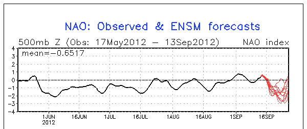
For days now, early indications are a strong upper level trough of much colder air will organize over central and eastern Canada as the North Atlantic Oscillation/Arctic Oscillation (NAO/AO) becomes decidedly negative (Fig - 1). The negative NAO/AO will instigate this troughing and colder air delivery to the Great Lakes. At this time; it appears these changes will commence early to mid week (Tue 9/18-Wed 9/19) time frame in the form of a few strong cold fronts that will surge through the region into late week.
Fig - 1
Of course at this early juncture; details of exact timing and intensity of the colder air remains to be seen but this time it appears it will be quite a change from the warm September we've become accustom to and bears watching; especially for outdoor garden and nursery enthusiasts! It is too early to say how cold it will get and if there's any risk of frost or freeze since it's so early in the season but thus far; I'm impressed on the model's cold air delivery. At times however; early cold outbreaks are handled poorly by meteorological models and thus, tend to be too aggressive but in any event; forewarned is to be forearmed if this does play out on the aggressive side.
I'll keep tabs on this evolving event and update as it becomes clearer just how much of a change is in store for the Great Lakes and Southeast Lower Michigan. Autumn's official arrival doesn't happen until Saturday; September 22nd at 1049AM EDT but at this time it appears it will have plenty of fanfare BEFORE that date!
Making weather fun while we all learn,
Bill Deedler -SEMI_WeatherHistorian
When is it going to snow??
ReplyDeleteWhen it's cold enough. Please we haven't had a killing frost, lets not rush the season. ;-)
ReplyDeletePretty nice post. I just stumbled upon your weblog and wanted
ReplyDeleteto say that I've truly enjoyed browsing your blog posts. In any case I will be subscribing to your rss feed and I hope you write again soon!
Thanks! I write fairly often on past, present and future weather.
ReplyDelete