Jun 11, 2013

Occasional Stalling Fronts, Possible Severe Weather And/Or Heavy Rains Highlights Our Early Summer As Dominant Upper Air Pattern Hangs Tuff!

In the last few weeks, our weather pattern across the country has been exactly what the late winter into spring pattern suggested in conjunction with wetter analogues in my Summer Outlook. The headline above tells the story along with normal to below normal temperatures. Why?  Put simply; the rather strong upper low and troughing periodically slipping into place over southeastern Canada has and continues to block summer-like air masses from fully taking over our region for more than just a few days. And thus, this conflict of the upper jet along with summer-type air masses and associated humidity that periodically set up a battle ground to our south this spring; has now crept north into the Lakes Region.
 

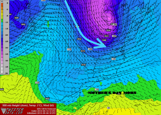
This upcoming projection of this Friday's upper jet stream shows an example of this well with the Canadian jet winning out at this time. Note; the warm jet stream surging from the southwest and southeast sections of the country while the quasi-stationary cool polar trough remains anchored over central to eastern Canada. This "conflict of interests" in air masses has created a battle zone (on map in green) this spring into early summer which is now showing signs of lifting north the past few weeks. This certainly would be expected by this time so that's not unusual. What is more the question "Will this continue for a longer duration and if not; which upper air feature will dominate the rest of the summer?" Typically, one would expect the upper ridge to become the more dominant with summer-time advancing but as our analogues suggested, this was not always the case and we either ended up with a cooler summer (with the Canadian trough holding) or a normal to warmer than normal summer as the upper ridge pushed more often into the region. In addition; now that Great Lakes Region has been brought into the conflict zone; the question of how wet will the summer become is also up for grabs.

From the original Outlook:

As the summer ridge builds into the center part of the country, I look for it to oscillate over the Great Lakes and the East, routinely bringing warm to hot weather to the region. However; it should be duly noted that the distinct upper air pattern that has been a key player since mid winter into spring, albeit naturally weakening with time and becoming less frequent, shows no signs of leaving during the summer. I'm speaking of the occasional blocking across the northern latitudes in which I expect to play a distinctive role this summer.  By occasionally phasing with weaker mid continental impulses, troughing will dive into the Great Lakes and points east and thus, intermittently deliver enough cooler spells of weather to balance out somewhat, the heat and humidity we do get for a more normal and comfortable summer than the past several.

Rainfall and Severe Weather Rainfall averaged decidedly below normal in the analogue set with about 75% below normal...a strong trend. However; the remaining years were very wet and while a minority of years, it still is an important subset of wet years! This suggests to me that the pattern portrayed in my hemispheric discussion could lead to a stalling of the frontal conflict and storminess and thus, runs the risk of repeating in the same general region. While analogues state drier summers prevailed; we still run the distinct risk of a stormier summer including training echoes if the pattern happens to stall in our neck of the woods. 

We have just entered this conflict zone the past few weeks which has brought above normal rainfall since late May. Much of May itself was very dry with all regions painting 1.5"- 2.0" below normal until the last week when roughly up to two inches fell. Another one to two inches (or more) has fallen since June 1st so we are off to a good start
for the growing season now. And latest indications suggest this pattern will persist for the time being.

Weekly Weather
Just this week we had one impulse slide over and to our south Monday which generated heavy rains across the region, with a second due shortly later Wednesday into Wednesday night. This low pressure and attendant warm and cold fronts is expected to ride near the Tri-State border of Indiana/Ohio/Michigan by Wednesday evening. Perhaps close enough to bring not only heavy rains but possibly severe weather as the very warm, tropical like atmosphere steams up over the Ohio Valley and runs rudely into our cooler, more stable air over the central Great Lakes Region (sound familiar).

The Storm Prediction Center has Southeast Lower Michigan outlined for the potential of severe weather Wednesday and Wednesday night with a greater risk over the Ohio Valley.

http://www.spc.noaa.gov/products/outlook/day2otlk.html


Stay alert to the NWS-DTX for any watches or warnings Wednesday and Wednesday night. Pop over here for a slide presentation from DTX for the potential for severe weather Wednesday into early Wednesday night.

Making weather fun while we all learn,
Bill Deedler -SEMI_WeatherHistorian


Jun 2, 2013

After Several Hot Summers; Finally a More Comfortable Summer in 2013?
Do Recent Atmospheric Conditions Foretell Our Summer?

The past three summer's across Southeast Lower Michigan have been bears at times for heat and misery. The Summer of 2012 was not only hot it was rather dry early in the season and thus, it was a tough growing season where water was not readily available. Beneficial rains came too late and too much, especially north of I-69 where heavy rains led to the wettest August on record at Saginaw with 9.3"

                                                         Summer of 2012      

Detroit's Hottest Summer's

Rank
Average Temp.
Year
1
74.8
2012
2
74.8
2005
3
74.5
1995
4
74.5
1955
5/6
74.4
2010/11


So dry was the southern two thirds of Southeast Michigan (especially after a hot and dry July) that the drought index crept up into our back yard. The map below showed the rainfall needed to alleviate the parched conditions by early August, 2012.


As mentioned above, to add  insult to injury the dry landscape in 2012 was parched with blazing sun and heat. Actually, this heat occurred in both July 2011 and July 2012!

Average Temperature Records for July
Detroit
Rank Average Temp. Year
1 79.3 2011
2 79.0 1955, 2012, 1921
5 77.9 1916
6 77.7 1931
Flint
Rank
Average Temp.
Year
1 78.0 1921
2 77.7 1935
3 76.8 2011
4 76.7 1934
5 76.5 1955
6 76.1 2012
Tri-Cities
Rank
Average Temp.
Year
1 77.5 1921
2 76.8 1916
3 76.4 2012
4 76.1 2011, 1935


                                                        Summer of 2011 / 2010        

While cooler (not making the top ten hottest summers) at Flint and Saginaw, the Summer of 2011's temperature average equaled that of 2010 at Detroit. Note the temperature placement for all three cities for the Summer of 2011 and 2010. Keep in mind, this chart was done before the Summer of 2012..so it is not included. The Summer of 2010 was an all inclusive hot summer for all three cities under the Hottest Summers list at the time.

Top 20 Coldest/Warmest Summers in Southeast Lower Michigan
 
RankDetroit Area*Flint Bishop**Saginaw Area***
ColdestWarmestColdestWarmestColdestWarmest
TempYearTempYearTempYearTempYearTempYearTempYear
166.5191574.8200565.4199274.2193364.8191573.01933
267.0199274.5199566.1200974.0193465.1199273.01931
367.3192774.5195566.2195872.7193665.5198272.51955
467.5187574.42010/1166.3196072.6193965.8194572.31995
567.6190374.2198866.5196972.6193165.9195072.11930
667.8198574.0193366.6200472.6192165.9192472.11921
767.9191273.8194966.7198572.3201066.1198572.02010
867.9190773.7192166.8197272.3194966.4200972.01988
968.1198273.6195266.8196772.2195566.4200472.01937
1068.2197273.5199166.9196272.0193566.4197971.91936
1168.3197973.5195966.9192771.9193866.5197771.71998
1268.3190273.5200267.0198271.81988/1166.6195171.51934


Heaviest rains and storms these two summers /2011-2010/ held over the southern tier of Southeast Lower Michigan...mainly from Ann Arbor to Detroit and south to the Ohio border. This led to the second wettest July on record at Detroit with 7.66" in 2011.  Curiously, this is not unlike the Summer of 2010 when much of the severe weather and heavy rains also fell south of I-94.

So all this is of the past; what about the future...this summer?

ENSO Conditions are Basically Worthless in Helping Project This Summer's Pattern

Below is the Pacific Sea Surface Temperatures /SST/ projected by the Euro Model for the summer. The concentration of the projections lie in the black rounded rectangle; or immediately south of the 0C line.


The latest ENSO projections have "basically" flat-lined into the summer. Flat-lined meaning they are and are expected to continue nearly dead-on neutral /La Nada/ for the summer. It is difficult enough during the winter season to investigate and project a dominant influence solely based on this sort of pattern; but for the summer, forget La Nada. At least during the winter, other patterns such as the NAO, AO, PDO and PNA are better relied on but in the summer, these too are generally weak and more transitory.

So then; what hints of a summer pattern and forecast is Mom Nature suggesting for this summer?

Temperatures

Recent hemispheric patterns and analogue summers (discussion below) suggest to me a more comfortable summer than the past several. In fact, temperatures should average closer to normal or average between 1.0 degrees below normal to 1.5 degree above. While quite variable, temperature patterns for the summer hint the primary (or  likely) temperature pattern for the summer is above normal temperatures early to mid summer with a close secondary (chance) during mid to late summer.

Rainfall

Dominant trends past (previous analogues) and recent (past few months) suggest variability in rainfall trends. April was wet while May was dry relative to normal or average rainfall. While the majority of analogue summers lean toward the dry side; a minority were especially wet! More discussion follows in the analogue section.

We've already seen this wider range variability recently and it looks like it will continue. When speaking of summer's total rainfall; I look for a range of below normal to above normal given the present and past trends. Areas these will occur at this early juncture is very much a crapshoot and only if we go by the recent trends of the spring and subtle analogue trends; heaviest rainfall is intimated to be from the I-96/696 corridor northward through Flint, Port Huron, Saginaw and the Thumb Region. 

Hemispheric Patterns

As the summer ridge builds into the center part of the country, I look for it to oscillate over the Great Lakes and the East, routinely bringing warm to hot weather to the region. However; it should be duly noted that the distinct upper air pattern that has been a key player since mid winter into spring, albeit naturally weakening with time and becoming less frequent, shows no signs of leaving during the summer. I'm speaking of the occasional blocking across the northern latitudes in which I expect to play a distinctive role this summer.  By occasionally phasing with weaker mid continental impulses, troughing will dive into the Great Lakes and points east and thus, intermittently deliver enough cooler spells of weather to balance out somewhat, the heat and humidity we do get for a more normal and comfortable summer than the past several.

The ECHAM model below, in my opinion, has picked up on the expected pattern I see evolving based on our recent and analogue pattern. Here I use its projected two meter /surface temperature/ for the country this summer with my estimated upper wind /500 MB/ pressures and flow.

                                  Projected  Summer 2013 Temperatures /C/ & Suggested Upper Wind Pattern


Summer Analogues

As one can see; the analogue summers below represent variable La Nina conditions that transitioned to Neutral.
 
                                        2013 Summer Neutral Analogues (following variable intensities of La Ninas)

Note: years where the la Nina to neutral pattern occurred for the second time in two year
or so are denoted with a “2” following the year. Normals used 1971-2000 for related years.


Analogue Trends Seen

Temperatures
The Neutral analogue summers are really quite mixed on the temperature front this time which is hardly surprising given the hemispheric and SST environment. Even though Detroit’s summer data favors normal to below normal temperatures, one must closely compare this data to Flint and Saginaw. The reason being, the normals at Detroit were increased in the past few data sets (1971-2000 & also 1981-2010) due to mainly the effect of the local heat island that now encompasses the Detroit Metro Airport; whereas Flint and Saginaw saw little change in their normals. This would logically then, skew Detroit’s departure temperature data down somewhat. In any event; analogues suggest normal temperatures will prevail.

Rainfall and Severe Weather
Rainfall averaged decidedly below normal in the analogue set with about 75% below normal...a strong trend. However; the remaining years were very wet and while a minority of years, it still is an important subset of wet years! This suggests to me that the pattern portrayed in my hemispheric discussion could lead to a stalling of the frontal conflict and storminess and thus, runs the risk of repeating in the same general region. While analogues state drier summers prevailed; we still run the distinct risk of a stormier summer including training echoes if the pattern happens to stall in our neck of the woods. In conjunction with this kind of scenario; there is more likelihood of a wider range of rainfall amounts from below normal to above over Southeast Lower Michigan.

Look for continuing updates and discussions on the summer pattern throughout the summer.

Summer commences on June 21st, 2013 @ 104 AM EDT. Enjoy the Summer!

Making weather fun while we all learn,
Bill Deedler -SEMI_WeatherHistorian


May 7, 2013

Update 5/13/13 - Alerted Cold Snap Lives Up to Forecast Days Ago!

5/13/13
Projected cold snap first warned about back on the 7th certainly lived up to its hype and then some with some areas actually dropping into the mid 20s. This air mass was even cold enough to match Detroit's record low /30/ first attained in 1971...long before any heat island became established around the airport...impressive! Also; that 30 tied for the coldest so late in the season at Detroit. Note, lows this morning across Southeast Lower Michigan after a very chilly and brisk Mother's day (highs).

 
MORNING TEMPERATURE AND PRECIPITATION SUMMARY
NATIONAL WEATHER SERVICE DETROIT/PONTIAC MI
929 AM EDT MON MAY 13 2013

VALUES REPRESENT YESTERDAY`S HIGHS....LOW OVER THE LAST 12 HOURS
AND PRECIPITATION OVER THE LAST 24 HOURS ENDING AT 8 AM EDT


.BR DTX  0513  ES DH00/TAIRZX/DH07/TAIRZP/TA/PPDRZZ/SFDRZZ/SDIRZZ


:SOUTHEAST MICHIGAN -- TEMPERATURE AND PRECIPITATION STATIONS
:....................................................................
:       STATION               MAX / MIN  / 8 AM / 24-HR / SNOW/ SNOW
:        NAME                 TEMP/ TEMP / TEMP / PRECIP/ FALL/ DEPTH
:....................................................................
WHKM4: NWS WHITE LAKE      :   47 /  26  /  33  /    T  /    T / 0
123M4: ANN ARBOR           :   49 /  28  /  30  /    T  /    T / 0
ADG  : ADRIAN AIRPORT      :   50 /  28  /  36  / 0.00
BAX  :*BAD AXE AIRPORT     :   43 /  33  /  38  /
CFS  :*CARO AIRPORT-TUSCOLA:   45 /  31  /  35  /
DET  : DETROIT CITY AIRPORT:   50 /  32  /  37  /    T
DTW  : DETROIT METRO ARPT  :   52 /  30  /  36  /    T  /  0.0 / 0
FNT  : FLINT BISHOP AIRPORT:   49 /  29  /  36  /    T  /  0.0 / 0
ONZ  :*GROSSE ILE AIRPORT  :   50 /  34  /  37  /
OZW  :*HOWELL AIRPORT      :   47 /  28  /  36  /
DUH  :*LAMBERTVILLE AIRPORT:   48 /  28  /  37  /
D95  :*LAPEER DUPONT AIRPRT:   46 /  30  /  35  /
IKW  :*MIDLAND AIRPORT     :   45 /  29  /  37  /
TTF  :*MONROE AIRPORT      :   52 /  28  /  37  /
RNP  :*OWOSSO AIRPORT      :   48 /  30  /  38  /
PTK  : PONTIAC AIRPORT     :   49 /  30  /  35  /    T
P58  : PORT HOPE           :   44 /  36  /  38  / 0.00
PHN  :*PORT HURON AIRPORT  :   48 /  30  /  36  /
MBS  : SAGINAW - TRI-CITIES:   48 /  30  /  36  /    T  /    T / 0
HYX  :*SAGINAW-HARRY BROWNE:   46 /  32  /  36  /
VLL  :*OAKLAND/TROY AIRPORT:   49 /  34  /  37  /
YIP  : YPSILANTI WILLOW RUN:   53 /  30  /  37  / 0.00
.END


*THE TEMPERATURE DATA FOR THESE SITES ABOVE REPRESENT THE HIGHEST AND
 LOWEST TEMPERATURES THAT WERE REPORTED ON THE METAR OBSERVATIONS
 THAT TRANSMIT THREE TIMES AN HOUR AND MAY NOT REPRESENT THE ACTUAL
 HIGH OR LOW FOR THAT SITE. THESE SITES DO NOT MEASURE
 PRECIPITATION.
.....................................................................


THE FOLLOWING COOPERATIVE OBSERVER SITES REPORT FROM MIDNIGHT TO
MIDNIGHT THE PREVIOUS DAY.


.BR DTX  0513  ES DH07/TAIRZX/TAIRZN/TA/PPDRZZ/SFDRZZ/SDIRZZ


:SOUTHEAST MICHIGAN -- TEMPERATURE AND PRECIPITATION STATIONS
:....................................................................
:       STATION               MAX / MIN  / 12 AM /24-HR / SNOW/ SNOW
:        NAME                 TEMP/ TEMP / TEMP  /PRECIP/ FALL/ DEPTH
:....................................................................
ARNM4: ADRIAN              :   49 /  31  /  32  / 0.00 /  0.0 / 0
MILM4: MILFORD - GM GROUNDS:   46 /  29  /  29  / 0.03 /  0.0 / 0
MDLM4: MIDLAND             :   45 /  33  /  33  / 0.01 /    M / M
MTCM4: MT CLEMENS SELFRIDGE:   51 /  35  /  35  /    T /  0.0 / 0
PRHM4: PORT HURON          :   48 /  37  /  38  / 0.06 /    M / M
SGNM4: SAGINAW 5W          :   45 /  33  /  34  /    T /    T / 0
.....................................................................


COOPERATIVE OBSERVATIONS VALUES ARE FOR APPROXIMATELY THE PREVIOUS 24
HOURS FROM YESTERDAYS OBSERVATION TIME TO TODAY`S OBSERVATION TIME.


.BR DTX  0513  ES DH07/TAIRZX/TAIRZN/TA/PPDRZZ/SFDRZZ/SDIRZZ


:SOUTHEAST MICHIGAN -- TEMPERATURE AND PRECIPITATION STATIONS
:..................................................................
...
:       STATION           OB   /MAX / MIN  /OB  /24-HR /SNOW/SNOW
:        NAME             TIME /TEMP/ TEMP /TEMP/PRECIP/FALL/DEPTH
:..................................................................
...
: ***MIDLAND COUNTY***


: ***BAY COUNTY***
AUBM4:  AUBURN            :0630/ 46 /  27 /  30 /    T/   M/   M


: ***HURON COUNTY***
BDAM4:  BAD AXE           :0705/ 44 /  33 /  35 / 0.04/   M/   M
FLNM4:  FILION 5NNW       :0645/ 44 /  33 /  35 / 0.00/   M/   M
POAM4:  PORT AUSTIN       :0738/ 43 /  35 /  36 / 0.00/   M/   M
PHPM4:  PORT HOPE         :0800/ 44 /  33 /  37 / 0.02/ 0.2/   0


: ***SAGINAW COUNTY***
MERM4:  MERRIL 2E         :0800/ 47 /  29 /  37 /    T/   T/   M
SAGM4:  SAGINAW           :0800/ 47 /  30 /  34 / 0.00/ 0.0/   0


: ***TUSCOLA COUNTY***
CARM4:  CARO              :0750/ 44 /  29 /  32 / 0.00/   M/   M


: ***SANILAC COUNTY***
LEXM4:  LEXINGTON         :0735/ 47 /  31 /  34 /    T/   M/   M
MRLM4:  MARLETTE          :0645/ 45 /  30 /  31 / 0.00/   M/   M
SANM4:  SANDUSKY          :0705/ 46 /  32 /  32 / 0.03/   M/   M


: ***SHIAWASSEE COUNTY***
CORM4:  CORUNNA 2NE       :0600/ 48 /  29 /  29 /    T/   T/   0
DRNM4:  DURAND            :0800/ 47 /  30 /  37 /    T/   T/   0
OWSM4:  OWOSSO            :0700/ 47 /  28 /  29 /    T/   M/   M


: ***GENESEE COUNTY***
BUNM4:  BURTON 4N         :M   /  M /  27 /  28 /    T/   M/   M
GODM4:  GOODRICH          :0730/ 47 /  29 /  31 / 0.01/   T/   0


: ***LAPEER COUNTY***
LPEM4:  LAPEER 2W         :0730/ 47 /  30 /  33 / 0.01/   T/   0
LPRM4:  LAPEER            :0730/ 47 /  30 /  32 / 0.00/   M/   M


: ***ST. CLAIR COUNTY***
YALM4:  YALE              :0655/ 45 /  30 /  31 /    T/   T/   0


: ***LIVINGSTON COUNTY***
HOWM4:  HOWELL            :0751/ 49 /  26 /  34 / 0.00/ 0.0/   0
WHLM4:WHITMORE LK 1N      :0700/ 48 /  26 /  27 / 0.00/ 0.0/   0


: ***OAKLAND COUNTY***
FARM4:  FARMINGTON        :0730/ 48 /  27 /  34 / 0.00/   M/   M
WSBM4:  WEST BLOOMFIELD   :0645/    /     /     /    T/   T/   0


: ***MACOMB COUNTY***
RICM4:  RICHMOND 4NNW     :0845/ 48 /  32 /  37 /    T/   T/   0


: ***WASHTENAW COUNTY***
AASM4: ANN ARBOR-SOUTHEAST:0730/ 50 /  27 /  33 /    T/   M/   M
AAWM4:  ANN ARBOR 1W      :0830/ 51 /  25 /  39 /    T/   T/   0
MCHM4:  MANCHESTER        :0705/ 48 /  28 /  28 / 0.00/   M/   M
SLNM4:  SALINE 4SW        :0800/ 50 /   M /  34 / 0.00/   M/   M
SALM4:  SALINE            :0800/ 50 /  27 /  33 / 0.04/   M/   M


: ***WAYNE COUNTY***
DBNM4:  DEARBORN          :0500/ 50 /  31 /  31 / 0.00/   M/   M
WYTM4:  WYANDOTTE         :0800/    /     /     /    T/   T/   0


: ***LENAWEE COUNTY***
MRIM4:  MORENCI           :0730/ 52 /  29 /  35 / 0.00/ 0.0/   0
TECM4:  TECUMSEH          :0630/ 51 /  30 /  30 / 0.00/   M/   M
TIPM4:  TIPTON 2WNW       :0800/ 48 /  29 /  36 / 0.00/   M/   M


: ***MONROE COUNTY***
DNDM4:  DUNDEE            :0650/ 49 /  30 /  31 / 0.00/   M/   M
MLIM4:  MILAN             :0738/ 49 /  29 /  34 / 0.00/   M/   M
MNRM4:  MONROE            :0900/ 50 /  27 /  39 / 0.00/   M/   M
NWPM4:  NEWPORT 4SSE      :0700/ 51 /  29 /  29 / 0.00/   M/   M
.END

5/12/13
The aggressive cold snap has come to fruition with just above low max's expected today with highs in the upper 40s to lower 50s.  As stated below, record low max's are in the lower to mid 40s and record lows overnight in the mid 20s to around 30 /Detroit - 44/1966, 30/1971; Flint 40/1966, 28/1946; Saginaw 42/1966, 26/1946 - note the record lows are for Monday morning/.   

Areas of frost and freezing temperatures are still expected overnight and if you have set out vulnerable vegetation, you may want to cover it. Seeds not germinated in the ground stand the best chance of surviving but are still vulnerable to a freeze.

A strong rebound in temperatures will come this week with readings rising through the 70s and into the lower to mid 80s by mid week.

________________________________________________________________________________  

5/8/13
Latest guidance continues the trend for the upcoming weekend into Monday. A rather potent cold front and subsequent air mass will dive across the Great Lakes and on into Southeast Lower on Saturday. Latest temperatures estimates are for lows in the 30s both Mother's Day morning and Monday; while highs drop sharply from the 60s Saturday to the upper 40s to lower 50s on Mother's Day. This is a somewhat impressive mini cold snap; rather sharp and quick hitting for just a couple of days. A brisk northerly wind will accompany the chill on Mother's Day.

For comparison; record low max's for Southeast Lower Michigan on Mother's Day, Sunday are in the lower to mid 40s while record lows on Sunday and Monday are in the upper 20s to lower 30s. Therefore; not too far away from record cold weather for the period.
_____________________________________________________________________
Original blog 5/7/13 1230am

It's interesting how we "backed-out" of winter this past month or so and on into spring.
Very much the same way we backed-out of autumn into winter; late and slowly. In the fall, even with each cooler wave of air it seemed warmer breezes returned and hung around much longer, refusing to give-way to winter. And again; the same thing could be said about spring as the colder, winter-like periods refused to give up the ship to spring.

So what now? Have to serious waves of colder air finally exhausted themselves? Are we free to assume spring air masses will rule the land? While the green-up is now in earnest as expected; is it safe to plant? I'd say yes for the most part BUT there seems to be one more hump to get by before there is more security in that statement. And that hump is the upcoming Mother's Day weekend or in which I'll refer to in meteorological terms and tongue-in-cheek as the "Mother's Day Curse"; or simply when Mother Nature gets to be "Mommy Dearest".

Mother's Day's is always the second Sunday of May which figures out to be anytime from May 8th to May 13th...Julian Day 128 - 133. I've noticed this "pattern" and I can't tell you how many times people complain to me about the "more than occasional" lousy weather on or around Mother's Day in Michigan. Is there any scientific data to back it up? The May 9th, 1923 snowstorm written about in my last blog would certainly fit the bill when Mom Nature certainly had a Mommy Dearest tantrum! How about the general temperatures in DTW data, any note of a pattern during that week or so?

A while back while I was at DTX, we ran DTW's (Detroit Metropolitan Arpt's) climatic data of the high temperatures only from 1958 to 2004, so not the entire Detroit climatic base. And, in this case (as with others) a graph or "picture" is worth a thousand words.

On the graph below we have; the highest category, termed "max" (record highs), "min" (record low maxs), means and standard deviations (%) of all those highs. In other words; the times the temperatures were at a certain standard deviation percentile or below. For example; looking at the graph below say at the 90th percentile at the highlighted interval, means 90 percent of the time the high temperatures either equaled or were less than the particular temperature in the left column. In this particular case, lower 80s are at the 90 percentile and thus, only 10% of the time the highs exceeded the lower 80s.


Again, during the time period mentioned above and highlighted on the graph; one can see the sideways to even down (especially the record low maxs which are shown on the graph as the min trace) of temperatures during the highlighted period, May 8th - 13th (Julian Day 128-133) or Mother's Day date possibilities.

The temperatures actually become a bit more erratic at that time. As mentioned, the most interesting and notable item that shows up is in the record low max's ("min"). See how the bottom blue min data line actually decreases from the first week of May; indicating a several degree slide in the record low maxs as slightly more potent cold air masses occurred during our point of interest - Mother's Day timing, 8th - 13th. Other data (traces) at the same highlighted time show a pause in rising temperatures even though we are proceeding toward the mid May time period. I know it's subtle "pause" but then compare it to the jump in all temperature fields (Max, 90th, 67th, Mean, 33rd, 10th and Min) the next six days from around day 134 to day 139. After; the same pattern roughly repeats all over again up then sideways, up then sideways. The period around Mother's Day happens to fall within that sideways (or even down a bit). Ultimately, the temperature pattern does becomes less variable as we "climb" into summer.

Mother's Day 2013

So, then how does this data relate to the upcoming Mother's Day? For that we have to look ahead at model guidance for our aforementioned period. General model consensus is for a sharpening colder trough to dig out of Canada for the upcoming weekend. The amplitude of this trough and cool surface high pressure to follow will bring colder, below average temperatures during the period roughly Saturday through Monday...or again, right around Mother's Day.


The bigger question at this time (and relating to our headline); will there be a risk of any frost/freeze with this air mass? At this early juncture; I'd say there will be just enough cold air at the surface, that we run the risk of some scattered frost and freezing temperatures but at this time, not a widespread heavy killing frost/freeze. Timing too is important and chilliest mornings are expected at this time to be Mother's Day morning and again, Monday morning.

Therefore make it simple; if you don't have to plant, especially tender vegetation, why risk it? Wait a few days because much warmer weather is projected to follow (sort of like our graph ;-)

Making weather fun while we all learn,
Bill Deedler - SEMI_WeatherHistorian


Apr 24, 2013

Record Breaking Late Season Snowstorm of April 23rd-25th 2005 and Incredible Snowstorm of May 9th 1923!


After 70 degree weather yesterday, yet again today it is snowing a various locations across Southeast Lower Michigan!  While our weather this spring has been much less than desirable, it has been worse; on this date in history and later. Take a look at my write-ups on just two of these memorable snows.

Record Breaking Late Season Snowstorm of April 23rd-25th 2005


With such an exceptionally variable and stormy winter it was actually fitting that the Winter of 2004-05 went out with a bang and not a whimper. If the persistent cold and snow during March wasn't enough to extend an already lengthy winter, Mother Nature really gave the inhabitants of Southeast Lower Michigan a sucker punch late in April.

A very nice stretch of sunny, dry (actually too dry) weather commenced late March into the first three weeks of April. This beautiful early spring weather reached a climax on the 19th when record highs were attained at all three climate stations (DTW/FNT/MBS). Ironically, not only did all three cities have record highs but it also was with the same temperature, 83 degrees. After the 19th, however, the weather was all downhill, accelerating big-time by the weekend. A series of cold fronts pushed south across the Michigan from the 20th to the 23rd, dropping temperatures some 40-50 degrees by the weekend /23-24th/!


An intense low pressure developed along an arctic cold front over the Upper Ohio Valley Saturday into Sunday and actually backed westward into the Eastern Lower Great Lakes (over Southwest Ontario - central pressure about 29.25" /986 MB/). This storm brought the worse late April weather seen in these parts in several decades. Snowfalls from the storm ranged wildly from a trace to as much as 16.5" with the heaviest falling across the highland areas from central Oakland County northeast into the Thumb Region (around Bad Axe). This very late snowstorm was the "icing on the cake" so to speak on what already had been a very snowy season. More information is available on April snows and total snowfall amounts from this storm. Incredibly, the May 9th, 1923 snowstorm which contained similar snow depths is over two weeks later!

The phasing of upper level jet steams, resulting in intensifying low pressure systems over Lower or Eastern Great Lakes have been responsible for some of our worst snowstorms; as evidenced by the above and following...

               ...Snowstorm of May 9th, 1923... 

Not since records have been kept in Southeast Lower Michigan      
(Detroit as far back as 1870), has the snowstorm of May 9th
in 1923 been equalled in season lateness and magnitude.

A strong cold front, of Arctic origin, pushed across Southeast
Michigan on the afternoon of the 8th, creating scattered thunder-
storms. The strength of the front was quite evident in Detroit.
The temperature plummeted from a near normal reading of 62
degrees at 100 pm to a winter like one of 34 degrees by 600 pm.
Behind the front, the stage was set for some startling weather    
developments for the month of May...even in Southeast Lower
Michigan. Rain mixed with snow fell across the area during the
evening of the 8th. Detroit received an estimated inch of snow
which melted on the ground before ending by midnight.

On the morning of the 9th, a low pressure area developed along
the front in northwest Ohio and moved over Lake Erie during the
afternoon. The developing low pulled warmer, moist air north from
the Ohio Valley and mixed with the unseasonably cold airmass
over Southeast Lower Michigan. As a result, a heavy, wet snow
began falling during the forenoon hours and continued through the
afternoon. Arguably, one of the most astonishing things (and
there were several) about the mid-spring snowstorm was that the
bulk of the snow fell during the time of day which is normally
considered "the heat of the day" or "afternoon heating" when
normal highs of the day are attained. The afternoon temperatures
never budged from the lower 30s (31-33) and was accompanied by
a stiff northwest wind, averaging 15 to 25 mph. Keep in mind,
the normal or average high for May 9th is 67...some 35 degrees
warmer! 

The snow ended by the evening in Detroit and at 800 pm, six
inches was reported on the ground. The story was even more
fantastic as one traveled west and north of Detroit across
Southeast Lower Michigan. Generally, six to nine inches fell 
west to the Ann Arbor area, northwest through Howell, north
across Pontiac and northeast up to Port Huron. Even more
incredible, snow depths of around a foot were reported at Flint
and Lansing north into the Saginaw Valley. Widespread damage was
reported to trees, power lines (many had a two inch circumference
of snow hanging on them) and telephone poles, especially in the
Saginaw Valley. Even so, economic damage was surprisingly small,
especially to spring vegetation. Evidently, the earlier spring
weather had been abnormally cold and this led to a late green up.
Substantial damage from the cold to vegetation and crops was
actually averted due to the insulation affect of the heavy, wet 
snow. Many May snow records (amounts and lateness in the season)
were shattered and stand firm to this day over Southeast Lower
Michigan.

By the next morning (10th), much of the snow had melted and by
the evening, it was just a memory. The official high in Detroit
on the 9th was 39, but that occurred just after midnight, before
the storm. The low was 31, which occurred in the afternoon during
the storm, giving a mean of 35 for the day and 21 degrees below
the normal of 56. Other May record snowfalls in Detroit pale in
comparison. In 1912, 1.5 inches fell on May 13th for the second
highest amount and the latest snow actually occurred the last day
of the month, May 31st, 1910 with a trace.

So, the next time you think it's too cold for this late in spring
or we can't possibly have a measurable snowfall in May across
Southeast Lower Michigan, you might want to THINK about it again
(or maybe not).
 
Making weather fun while we all learn, 
Bill Deedler -SEMI_WeatherHistorian


Apr 23, 2013

Finally an Extended Surge of Warm, Spring Weather To Encourge a Rapid Green Up!

One more cool down for the time being is all we'll have to endure before spring comes on more aggressively as we turn the calendar from April to May! Finally, Mom Nature will give us a surge of extended spring weather we have yet to see thus far. Latest indications are the colder, below normal temperatures plaguing much of the northern, central and Great Lakes region will hit the road for a longer time frame beginning by this weekend.

The warm, spring-like weather of today will once again go by the wayside as another aggressive cold front (the last in the series, for awhile anyway) moves through the region overnight and returns the region to below normal temperatures for a few days. But alas, have faith as latest extended model trends show the colder air to retract back to the northwest over Alaska, Western Canada and the Pacific Northwest during the coming weekend into next week (see 500 MB Jet maps below). After that however; extended guidance diverges on the first weekend of May; so get out and enjoy the much deserved warmer, spring weather as temperatures jump back into the 60s and 70s and possibly some 80s.


Making weather fun while we all learn,
Bill Deedler -SEMI_WeatherHistorian