Oct 5, 2012

10/8 Update; A Cold and Frosty Columbus Day Greets Inhabitants of Southeast Lower Michigan

Widespread frosts and areas of freezing temperatures engulfed Southeast Lower Michigan this Columbus morning under brilliant sunshine. Before that sunshine, temperatures dropped well down into the 20s and 30s at most locations. As would be expected; sheltered areas along with lake influenced areas escaped the worst of the cold. Check out the low temperatures on the NWS regional temperatures/precipitation table. Keep in mind the second table of several; reflects 24 hour low temperatures ending at midnight. Coldest temperatures were found around the Saline area where readings crated to the lower 20s!

000
ASUS63 KDTX 081503
RTPDTX
MORNING TEMPERATURE AND PRECIPITATION SUMMARY
NATIONAL WEATHER SERVICE DETROIT/PONTIAC MI
1103 AM EDT MON OCT 8 2012

VALUES REPRESENT YESTERDAY`S HIGHS....LOW OVER THE LAST 12 HOURS
AND PRECIPITATION OVER THE LAST 24 HOURS ENDING AT 8 AM EDT


.BR DTX  1008  ES DH00/TAIRZX/DH07/TAIRZP/TA/PPDRZZ


:SOUTHEAST MICHIGAN -- TEMPERATURE AND PRECIPITATION STATIONS
:.......................................................
:       STATION              MAX / MIN  / 8 AM  / 24-HR
:        NAME                TEMP/ TEMP / TEMP  / PRECIP
:.......................................................
WHKM4: NWS WHITE LAKE      :   47 /  29  /  33  /    T
ARBM4: ANN ARBOR           :   46 /  30  /  30  / 0.06
ADG  : ADRIAN AIRPORT      :   48 /  28  /  31  / 0.02
BAX  :*BAD AXE AIRPORT     :   50 /  28  /  31  /
CFS  :*CARO AIRPORT-TUSCOLA:   50 /  26  /  29  /
DET  : DETROIT CITY AIRPORT:   51 /  35  /  36  /    T
DTW  : DETROIT METRO ARPT  :   50 /  33  /  34  /    T
FNT  : FLINT BISHOP AIRPORT:   51 /  29  /  34  / 0.01
ONZ  :*GROSSE ILE AIRPORT  :   50 /  39  /  41  /
OZW  :*HOWELL AIRPORT      :   47 /  33  /  34  /
DUH  :*LAMBERTVILLE AIRPORT:   49 /  32  /  32  /
D95  :*LAPEER DUPONT AIRPRT:   50 /  27  /  28  /
IKW  :*MIDLAND AIRPORT     :   49 /  26  /  30  /
TTF  :*MONROE AIRPORT      :   48 /  30  /  30  /
RNP  :*OWOSSO AIRPORT      :   50 /  33  /  38  /
PTK  : PONTIAC AIRPORT     :   48 /  31  /  31  /    T
P58  : PORT HOPE           :   52 /  34  /  34  / 0.00
PHN  :*PORT HURON AIRPORT  :   50 /  27  /  28  /
MBS  : SAGINAW - TRI-CITIES:   50 /  32  /  33  / 0.05
HYX  :*SAGINAW-HARRY BROWNE:   50 /  32  /  34  /
VLL  :*OAKLAND/TROY AIRPORT:   50 /  34  /  35  /
YIP  : YPSILANTI WILLOW RUN:   50 /  32  /  36  /    T
.END


*THE TEMPERATURE DATA FOR THESE SITES ABOVE REPRESENT THE HIGHEST AND
 LOWEST TEMPERATURES THAT WERE REPORTED ON THE METAR OBSERVATIONS
 THAT TRANSMIT THREE TIMES AN HOUR AND MAY NOT REPRESENT THE ACTUAL
 HIGH OR LOW FOR THAT SITE. THESE SITES DO NOT MEASURE
 PRECIPITATION.
.....................................................................


THE FOLLOWING COOPERATIVE OBSERVER SITES REPORT FROM MIDNIGHT TO
MIDNIGHT THE PREVIOUS DAY.


.BR DTX  1008  ES DH07/TAIRZX/TAIRZN/TA/PPDRZZ


:SOUTHEAST MICHIGAN -- TEMPERATURE AND PRECIPITATION STATIONS
:.......................................................
:       STATION               MAX / MIN  / 12 AM /24-HR
:        NAME                 TEMP/ TEMP / TEMP  /PRECIP
:.......................................................
ARNM4: ADRIAN              :   46 /  38  /  39  / 0.04
MILM4: MILFORD - GM GROUNDS:   45 /  34  /  36  / 0.03
MDLM4: MIDLAND             :   50 /  36  /  38  / 0.00
MTCM4: MT CLEMENS SELFRIDGE:   51 /  39  /  43  /    T
PRHM4: PORT HURON          :   53 /  37  /  42  / 0.00
SGNM4: SAGINAW 5W          :   50 /  35  /  35  / 0.00
.....................................................................


COOPERATIVE OBSERVATIONS VALUES ARE FOR APPROXIMATELY THE PREVIOUS 24
HOURS FROM YESTERDAYS OBSERVATION TIME TO TODAY`S OBSERVATION TIME.


.BR DTX  1008  ES DH07/TAIRZX/TAIRZN/TA/PPDRZZ


:SOUTHEAST MICHIGAN -- TEMPERATURE AND PRECIPITATION STATIONS
:.........................................................
:       STATION            OB   /MAX / MIN  / OB   /24-HR
:        NAME              TIME /TEMP/ TEMP / TEMP /PRECIP
:.........................................................
: ***MIDLAND COUNTY***


: ***BAY COUNTY***
AUBM4:  AUBURN            :0630/   50 /  28  /  32  / 0.00


: ***HURON COUNTY***
BDAM4:  BAD AXE           :0700/   50 /  32  /  32  / 0.00
FLNM4:  FILION 5NNW       :0620/   51 /  32  /  32  / 0.00
POAM4:  PORT AUSTIN       :0740/   50 /  32  /  33  / 0.05
PHPM4:  PORT HOPE         :0800/   51 /  31  /  33  / 0.00


: ***SAGINAW COUNTY***
SAGM4:  SAGINAW           :0800/   51 /  31  /  32  / 0.00


: ***TUSCOLA COUNTY***
CARM4:  CARO              :0800/   51 /  31  /  32  / 0.00
VSSM4:  VASSAR            :0700/   51 /  26  /  27  / 0.00


: ***SANILAC COUNTY***
LEXM4:  LEXINGTON         :0730/   51 /  32  /  33  / 0.00
SANM4:  SANDUSKY          :0700/   50 /  33  /  33  / 0.00


: ***SHIAWASSEE COUNTY***
CORM4:  CORUNNA 2NE       :0600/   50 /  32  /  32  / 0.00
DRNM4:  DURAND            :0800/   50 /  32  /  36  /    T
OWSM4:  OWOSSO            :0700/   51 /  31  /  33  /    T


: ***GENESEE COUNTY***
BUNM4:  BURTON 4N         :0700/   52 /  27  /  28  /    T
FLTM4:  FLINT  7W         :0800/   49 /  30  /  34  /    T
LIDM4:  LINDEN            :1030/   47 /  31  /  41  / 0.00
GODM4:  GOODRICH          :0730/   51 /  30  /  31  / 0.03


: ***LAPEER COUNTY***
LPEM4:  LAPEER 2W         :0900/   51 /  28  /  33  / 0.00
LPRM4:  LAPEER            :0730/   50 /  30  /  30  / 0.00


: ***ST. CLAIR COUNTY***
AGCM4:  ALGONAC           :0835/   55 /  34  /  43  / 0.00
YALM4:  YALE              :0700/   52 /  31  /  32  / 0.00


: ***LIVINGSTON COUNTY***
HELM4:  HELL              :0930/   44 /  29  /  39  / 0.06
HOWM4:  HOWELL            :0800/   48 /  26  /  27  / 0.01
WHLM4:WHITMORE LK 1N      :0700/   45 /  29  /  29  / 0.00


: ***OAKLAND COUNTY***
FARM4:  FARMINGTON        :0730/   48 /  28  /  28  / 0.00
PONM4:  PONTIAC           :0811/   49 /  33  /  34  / 0.01
WSBM4:  WEST BLOOMFIELD   :0730/      /       /     / 0.05


: ***MACOMB COUNTY***
RICM4:  RICHMOND 4NNW     :0800/   55 /  27  /  30  / 0.00


: ***WASHTENAW COUNTY***
AASM4: ANN ARBOR-SOUTHEAST:0730/   48 /  28  /  28  / 0.03
AAWM4:  ANN ARBOR 1W      :0830/   47 /  29  /  33  / 0.02
MCHM4:  MANCHESTER        :0641/   45 /  28  /  28  / 0.02
SLNM4:  SALINE 4SW        :0800/   48 /  21  /  26  / 0.00
SALM4:  SALINE            :0800/   42 /  22  /  25  / 0.00


: ***WAYNE COUNTY***
DBNM4:  DEARBORN          :0900/   53 /  34  /  37  /    T
WYTM4:  WYANDOTTE         :0800/      /       /     / 0.01


: ***LENAWEE COUNTY***
BLIM4:  BLISSFIELD 1SW    :0707/   48 /  29  /  29  /    T
MRIM4:  MORENCI           :0730/   51 /  28  /  28  / 0.00
TECM4:  TECUMSEH          :0630/   47 /  30  /  32  / 0.05
TIPM4:  TIPTON 2WNW       :0800/   48 /  27  /  29  / 0.08


: ***MONROE COUNTY***
DNDM4:  DUNDEE            :0645/   47 /  32  /  32  / 0.03
MLIM4:  MILAN             :0757/   45 /  31  /  31  / 0.06
MNRM4:  MONROE            :0730/   49 /  31  /  31  /    T
NWPM4:  NEWPORT 4SSE      :0700/   50 /  35  /  37  / 0.00
.END


* ALL DATA ABOVE IS PRELIMINARY AND HAS NOT UNDERGONE FINAL QUALITY
CONTROL BY THE NATIONAL CLIMATIC DATA CENTER /NCDC/.  THEREFORE...
THIS DATA IS SUBJECT TO REVISION.  FINAL AND CERTIFIED CLIMATE DATA
CAN BE ACCESSED AT WWW.NCDC.NOAA.GOV.
 
------------------------------------------------------------------------------------------------------

10/6-8 Update
Little change from previous thinking as coldest overnights will be Saturday night into Sunday and then, Sunday night into Monday. While this air mass is certainly old enough for frost/freezing conditions; patchy clouds and steady wind off of the warmer Great Lakes can work against it. With partial to mostly clear skies and lighter winds; low temperatures have to potential to drop as low as the mid 20s to mid 30s. Areas away from the city of Detroit and Great Lake/ shores are at greatest risk for both frost and freezing conditions.

All persons with vulnerable plants outside may want to bring them indoors, shelter or at the least; water them to give them some protection from the cold. Autumn color enthusiast should note this weekend's cold, breezy air mass will hasten leaf change and encourage leaf drop. The fall color show across Southeast Lower Michigan should peak within the next week to ten days.

This will not be the last in the series of cold plunges in the upcoming week as a "sister" cold air mass is waiting in the wings to surge out of Canada by mid-week. Early indications are this air mass will be as cold, if not colder than the one this weekend and will contribute in closing down this season's growing season.

-----------------------------------------------------------------------------------------------------

10/3 Update
The impressive cold air and dynamics with this early October blast is on track to flood into Southeast Lower Michigan beginning this Friday with the coldest of air engulfing the region, generally over the weekend. The risk of frost and freeze still appears great; especially if skies clear and winds lighten up some. Under these frost/freeze inducing conditions; the coldest morning when temperatures could fall as low as the mid 20s to mid 30s appears to be Sunday or Monday morning but I will update as we move into the weekend.

The upper air and surface projections of this blast are very impressive for early October. Note the -35C
temperature /500 MB;18kft/ in that western cold core swinging into the Dakotas Friday morning! Of course, the 540 MB low parked aloft over the shores of Lake Superior is nothing to sneeze at either! 


Then by Sunday morning; The whole eastern half of the country is engulfed in the cold on this 500 MB/18kft
map. What really struck me was the projected fairly large cold core of  -35C to -40C temperatures west of James Bay Canada. This is the first week of October, people!


Meanwhile; at the surface where it really matters to us gardeners and nurseries, etc etc....
Note the widespread cold air already over southern Canada extending across much of the North-Central and upper Midwest region of the U.S. with much of this region is in the 20s/30s.


Now, the impressive cold air and upper air dynamics with this sharp October blast has been duplicated (and then some) in the recent past; especially the past decade.

From my Autumn summary of 2009 (and sounds eerily similar to expectations with this October's blast)...

With the change in month, came the abrupt temporary change in autumn’s overall pattern. A strong amplified upper air pattern brought pre‐season Polar cold resulting in temperatures hovering in record cold territory during the first half of the October. Most areas saw a killing frost/freeze by the second weekend of October (roughly a week ahead of schedule, depending on location) but interestingly (especially considering the strength of the cold) none of the three official climate sights reported snow in October.

Another sharp cold blast that hit October of 2006  was by far, the worst October cold snap of recent memory also containing early record snows; From my October 2006 write-up 

The most dismal weather seemed to come at the peak autumn color show across the region. No doubt the worst of weather in October (and likely the fall) came mid-month on the 12th with a record breaking cold blast of Arctic air. The storm had an uncanny resemblance to very old record setting storm itself, back on October 13th, 1909. Both systems contained impressively deep centers / around 29.00”/ and air straight out of cold core depths of the Arctic. They also took similar tracks and blasted same region with heavy snow, lake effect snow and again, exceptional cold for October. Blustery heavy snow showers bombarded the land with visibilities, at times, dropping to white out conditions.

Then in OCTOBER 2004 

NEAR RECORD COLD FIRST WEEK OFFSET BY INDIAN SUMMER WEATHER THE LAST WEEK

October had been a cool month, especially in the beginning when temperatures fell into the mid 30s with several mornings during the first week having some frosty conditions. A low of 35 degrees on 5th at Detroit Metro - and 25 degrees here at White Lake - was accompanied by a killing frost and hard freeze in Detroit's north/west suburbs. Later on the 17th/18th, another plunge of polar air brought temperature back down into the 30s and for the most part, ended the growing season for 2004 across the remainder of Southeast Lower Michigan. Big changes in the upper wind flow to a predominant southwest flow took place during the last third of the month and brought much warmer weather to the region. Temperatures pushed well up into the 60s throughout the last week of the month and peaked at 75 degrees on the 30th (second highest tem

October 2003
October opened in the depths of some of the unseasonably cold air that arrived late in September. A strong polar high pressure pushed the cold air south into the area from Northern Canada. So cold was it on the 1st, that several locations noted snow flakes mixed in with rain showers. While that was the case here at the NWS in White Lake, it was not officially at Detroit Metro Airport. If snow had been observed there, it would have tied the earliest date for snowfall officially observed at Detroit /Oct 1st 1974/. The chill hung around for the nearly the entire first week of the month. High temperatures held down in the 50s, while lows fell into the upper 20s to upper 30s. 

 OCTOBER OF 2002 
WILL BE REMEMBERED ACROSS SOUTHEAST LOWER MICHIGAN FOR ITS NOTABLE CONTRASTING TEMPERATURE PATTERN. THE MONTH ARRIVED LIKE SEPTEMBER ENDED WITH UNSEASONABLY WARM WEATHER PRODUCING RECORD OR NEAR RECORD WARMTH. A HIGH TEMPERATURE AT DETROIT METRO AIRPORT OF 86 ON THE 1ST CAME WITHIN 2 DEGREES OF THE RECORD /88/. THAT HIGH OF 86 CHALLENGED BUT WAS UNABLE TO BREAK THE RECORD HIGH THAT CONTINUES TO STAND FOR OVER A CENTURY...SET WAY BACK IN 1897. THE LOW OF 66 AND AVERAGE TEMPERATURE OF 76 WERE...HOWEVER...THE WARMEST TEMPERATURES EVER SEEN ON OCTOBER 1ST. ANOTHER HIGH IN THE 80S /81/ CAME ON THE 4TH AND WAS A GOOD 15 DEGREES ABOVE NORMAL. THE SUMMER-LIKE WEATHER WITH TEMPERATURES IN THE 80S WAS ENDED ON THE 4TH BY A STRONG COLD FRONT THAT CHURNED-UP A SQUALL-LINE OF SHOWERS AND WIND GUSTS UP TO AROUND 45 MPH

 BIG CHANGE CAME MID MONTH AS THE UPPER WIND PATTERN SHIFTED FROM A DOMINANT SOUTHWESTERLY FLOW TO NORTHWESTERLY. THE COLDER SECOND HALF OF OCTOBER CAUSED THE AVERAGE TEMPERATURE TO DROP OVER TEN DEGREES TO 50 DEGREES BY MONTH'S END! THE WELL ABOVE NORMAL COOLING DEGREE DEPARTURE FOR THE MONTH...DESPITE THE BELOW NORMAL MONTHLY AVERAGE TEMPERATURE...FURTHER UNDERLINES THE CONTRASTING TEMPERATURE PATTERN OF THE MONTH. IN SPITE OF THE COLDER SECOND HALF OF OCTOBER...NO RECORD LOWS WERE SET. FROST AND FREEZES DID...HOWEVER...PRETTY MUCH ARRIVE ON SCHEDULE ACROSS SOUTHEAST LOWER MICHIGAN BY MID MONTH. THE FIRST FREEZING TEMPERATURE /30 DEGREES/ AT DETROIT METRO AIRPORT WAS RECORDED ON THE 14TH. 

However, on the Flip-side;

We've also seen some impressive warmth lately in October as evidenced by the 70s/80s last year in the first half of October 2011. A record high of 90! on yours truly's birthday; October 8th 2007 at Detroit Record highs also occurred at both Flint and Saginaw for a couple of days at that time. Here is more on that warm stretch that actually held for the first six weeks of fall 2007!

October 2007 was near the top with the 6th warmest on record at Detroit with a record base of 137 Octobers /1871/, impressive! Over at Flint with a +8.1 departure, October 2007 became the 4th warmest on record since 1942, while at Saginaw with a +7.3 departure, placed October in 6th warmest since 1899.  The best stretch of warm weather came from the 7th through the 11th when temperatures surged into the 70s and 80s, and then again from the 23rd into the 27th, when readings rose into the mid 60s to mid 70s. Temperature averaged around 10 to 15 degrees above normal during these warm spells. 

October of 2005 also saw record warmth during the first week of the month with record highs in the upper 80s at both Detroit and Saginaw.

Yes, October around here is by nature, a changeable, feast or famine month especially when it comes to temperatures. But; just a little more so in the past decade...hmmmm.

Making weather fun while we all learn,
Bill Deedler -SEMI_WeatherHistorian


_____________________________________________________________________________
Previous blog on October Frost/Freeze potential

9/30/2012
Just a brief heads up for the first weekend of October:

Latest indications are a stronger cold blast is slated to push southeast out of Canada late this week into the weekend; which is similar timing to the last one. Very early indications are this one may very well have more punch with it as far as cold enough temperatures to bring a more substantial frost and freeze to all of Southeast Lower Michigan.

We are coming up to the time when Southeast Lower Michigan on average, experiences a killing frost/freeze; generally the second to third week of October. Therefore, if this pans out; we will be a little ahead of schedule. Stay Tuned....

Sep 30, 2012

Long Range Models Indicating Strong Blocking Pattern Shaping Up For Early October

We saw this transitory blocking in September when our first autumn cold blast sent temperatures down to near record cold territory. Now; latest indications are that another blast of cold air will dive out of Canada late this first week of October; prompting my previous Frost/Freeze blog. A strong ridge/trough blocking pattern is being forecast by the majority of models for the first half of October commencing this upcoming weekend. This pattern would bring a cooler than normal October to Southeast Lower Michigan if it were to dominate during the month. But have heart; an amplified upper air pattern during the fall months of October and November also brings the likelihood of a spell or two of Indian Summer weather. What do I mean by blocking pattern? See for yourself; below. Note the strong ridge of high pressure along the west coast of North America and the huge, cold low pressure trough that extends from Siberia, across the Pole into the eastern half of North America. A Blocking Pattern means just that; the atmosphere upper wind pattern gets "blocked" and therefore, the pattern stalls and remains constant over the same region for several days or even weeks. 

.
                              Sunday Night October 7th 2012 - Polar Projection of North America


This strong blocking pattern setting up this October bears watching for any further developments into the fall as a possible hint to the coming winter. Years back, I did an in-house research study on cold or below normal Octobers and their possible relevance to a colder than normal upcoming winter. The paragraphs below come from my Winter 2002-03 Outlook which was also, like this upcoming winter, at the onset of another weak-moderate El Nino winter.


An important change came in October (and again, one of the few cool Octobers in the study) when abnormally cold air surged into the region mid month. While the timing of the polar blast duplicated most in the study its strength and dominance was atypical. The monthly average temperature for October 1977 was a cool 47.9 degrees /normal 51.9/ at Detroit. Curiously, this same pattern was noted in the fall of 1972 and again, this abrupt change surfaced in October. October of 1972 not only turned out to average well below normal, but with nearly the same average temperature as October 1977 with 47.3 degrees. 


While October 2002 remained warm until mid October, the recent abrupt change to a deep 500 MB trough over the eastern half of the country resulting in much colder weather bears watching, especially if it represents an intermediate trend change to the past several months. In addition, the near-term projections of the EPO and NAO both indicate, at least short term, negative phases and this too bears watching for any overall, longer term trend change. 
 

October 2002 was much like the other notably cool Octobers mentioned in the research as ironically, October 2002's weather also abruptly changed from a balmy summer-like beginning to a late fall-like ending; changing in mid-month. During the first half of the month, the temperature averaged 60.4 degrees at Detroit, but by the end of the month, the average temperature had dropped to 50 degrees at Detroit (and 47.6 at Flint) or 1 to 2 degrees below normal. One of the analogue winters I mentioned I was researching in my Autumn Outlook for possibly using for this winter, was the Winter of 1976-77. From my Autumn Outlook:


Weak to even moderate El Nino conditions along with a NAO-/AO- in the winter are notorious for active weather patterns across the country. One of my earlier studies presented such a case (Winter of 2002-03; a moderate El Nino). A new set of analogues are already being decided upon and watched for similarities to this autumn into winter pattern projected. In regards to a weak El Nino winter; one possible candidate of many is the Winter of 76-77 but it is much too early to let those "cats" out of the analogue bag just yet. One must see how the "birth" of our new El Nino plays out this fall and how he interacts with the phase(s) of the NAO/AO. Stay tuned.


The Winter of  '76-77 was an exceptionally brutally cold winter across the Great Lakes and actually much of the country east of the Rockies as the strong blocking pattern discussed above remained in place for basically several months; only occasionally breaking down. The upper and surface wind pattern THAT fall was one of progressively colder air masses spilling down from Siberia across the Arctic into the eastern half of the country. And; if memory serves me, it was when the phase "Siberian Express" was first coined. It was very early in my career and I remember the seasoned lead forecasters just amazed at the unusually cold core upper lows that dropped out of the Arctic and became displaced and lodged much further south than typically seen...oscillating between James Bay, Canada and the Great Lakes. From month of October; onward into the winter months of December and January, the below normal departures were larger than the month before so that by January; the monthly below normal departure handily exceeded 10 degrees!


1976-77 Fall-winter monthly averages at Detroit:


         Sep               Oct               Nov        Dec   /   Jan

       62.1       
      47.4       
     33.5      
21.5  /   12.8


In Conclusion;

Does this all mean my outlook for the Winter of 2012-13 is likely to call for a colder than a normal winter?  Not necessarily as the discussed above pattern change has yet to be confirmed. This is just one more card that mother nature may be showing us from her elusive meteorological hand. It IS however, I believe an important card and possibly a trend to watch for as we advance through the remainder of autumn. As stated above when researching in 2002; more of than not, a confirmed abrupt pattern change in October may very well foretell of things to come. We shall see!


 Making weather fun while we all learn,
Bill Deedler -SEMI_WeatherHistorian

Sep 25, 2012

Hurricanes in Michigan???

                                                 
 Originally written September 1999 & Updated September 2004/2012

This week is the anniversary of one of the most unusual and intense wind storms ever to hit Southeast Lower Michigan. It was over seven decades /71-yrs/ ago on September 25th, 1941 when the remnants of a tropical storm hit the region. This storm by far, was not the usual remnants of tropical origins that occasionally make it up to the Great Lakes region but one of extraordinary circumstances for it truly was the Astonishing Storm of September 25th, 1941

At first glance, when one reads that headline, one might say, "What? Hurricanes here in the Great Lakes?? No way!" Of course you'd be right, no actual hurricane has ever been observed in Michigan under the true definition of a hurricane. The definition of a hurricane, according to the Glossary of Weather and Climate edited by Ira W. Geer, is as follows: "A severe tropical cyclone with maximum 1-minute sustained surface wind speed greater than 64 knots (74 mph) in the North Atlantic Ocean, Caribbean Sea, Gulf of Mexico and the Eastern North Pacific off the west coast of Mexico to the International Dateline. West of the Dateline they are known as typhoons." Furthermore, the definition of a tropical cyclone is as follows: "A generic term for a non-frontal synoptic-scale cyclone originating over the tropical or subtropical waters with organized convection and a definite cyclonic surface wind circulation." Clearly, neither definition applies in the Great Lakes area, although remnants of hurricanes that have become extratropical (loses its tropical characteristics) occasionally do make their way into the Great Lakes region.

Scanning over 80 years (since 1921) worth of hurricane track data suggests that remnants of a hurricane or tropical storm make their way into the Great Lakes region on an average of twice a decade, especially the southern Great Lakes area (see Table-1). Also, in the majority of instances, by the time they visit this region they have diminished to an area of rain with maybe some squally winds. There have been a few instances, along the way, however, that do bear mentioning, and ONE STORM in particular that screams for attention!

TABLE - 1

REMNANTS OF TROPICAL STORMS THAT HAVE AFFECTED THE GREAT LAKES AND SOUTHEAST LOWER MICHIGAN (SINCE 1921)
 
DATE (Storm's life cycle)
DETROIT RAINFALL/DATES (Inches)
MAXIMUM WIND (mph)
 
10/16-19 1923
.55 - 10/18
SE - 22
 
7/20-8/2 1926
1.11 - 8/1
E - 25
 
8/27-9/3 1932
2.95 - 9/3-4
NE - 21
 
9/10-22 1938
.23 - 9/21-22
SW - 20
 
9/16-25 1941
Trace - 9/25
SW - 52 *
 
9/1-6 1948
.82 - 9/6-8
N - 25
 
9/27-10/6 1949
1.30 - 10/6-7
SW - 21
Connie -
8/1-8/14 1955
.69 - 8/13-14
W - 20
TD ** -
6/22-6/28 1960
.31 - 6/28
SW - 23
Carla -
9/3-9/15 1961
.13 - 6/14
W - 29
Candy -
6/22-26 1968
2.55 - 6/24-26
NE - 30
Hugo -
9/10-24 1989
Trace - 9/22-23
NW - 38
Opal -
9/27-10/6 1995
1.41 - 10/5-6
N - 38
Fran -
8/23-9/8 1996
.99 - 9/7
NW - 25
Isabel -
9/6-9/19 2003
0.25 - 9/18-19 #
W - 33

* denotes officially at Detroit City Airport, but gusts were clocked up to 75 mph across the Metro Detroit area.
** TD - Tropical Storm
# Up to 2.50" reported along the St. Clair River

First off, under the "mention" category in 1932 (well before hurricanes were named), a hurricane that developed in the Caribbean on August 27th, tracked northwest into the Gulf of Mexico, then generally north, across Alabama, eastern Arkansas, southeast Missouri, into southern Illinois and then from there, headed northeast across Indiana into Southeast Lower Michigan. The storm approached Southeast Lower Michigan late on September 3rd. A light to moderate northeast wind proceeded the storm on the 2nd and 3rd averaging around 11 mph with gusts into the lower 20s, hardly anything noteworthy wind-wise. The storm did however, pass right over Detroit, causing the barometric pressure to fall from around 30.20 inches early on the 2nd to around 29.60 late on the 3rd. Rain began to fall lightly but steadily early in the morning on the 3rd, but from mid afternoon into the evening, moderate to heavy rain fell and by midnight, over two and a half (2.55) inches was dumped on the Detroit area. Close to an additional half inch or so of rain was added to that on the 4th for a total of nearly three inches.

Another "mentionable" was odd from the start because of its timing, occurring very early in the season during late June of 1968 (only one other June system was found since 1921 to have affected the Great Lakes: the weak remnants of a tropical storm that moved from the Gulf of Mexico to near Chicago, June 22-28th, 1960). On June 22, 1968, Tropical Storm Candy formed off the coast of eastern Mexico and then headed north into southeast Texas, just north of Corpus Christi. She then weakened, headed north-northeast through eastern Texas and Oklahoma, central Missouri and Illinois, then she pivoted on a more easterly track across northern Indiana into extreme northwest Ohio, over Toledo. Candy began to influence Southeast Lower Michigan's weather on the morning of the 25th. A nearly steady rain, interspersed with a few thunderstorms, continued through the day and evening, depositing nearly two and a quarter (2.17) inches. More scattered, lighter showers fell on the 26th, adding another .38 to give a grand total of 2.55. Through it all, an east to northeast wind blew averaging 10 to 14 mph with gusts into the 20 to 30 mph range.

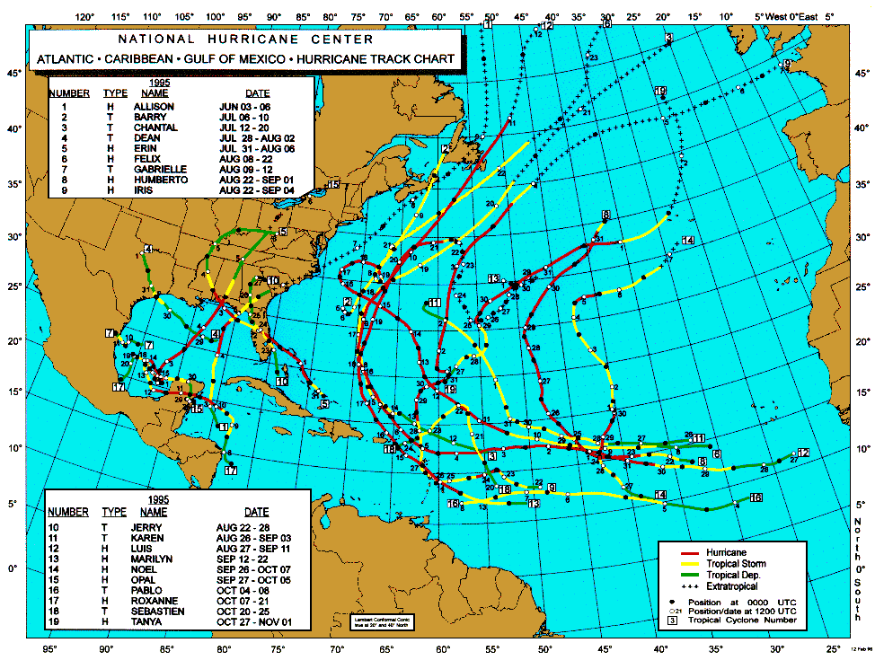
A more recent storm (and last under the mentionable category) was fairly impressive as it wound its way north out of the Gulf of Mexico, through Alabama, Tennessee, Kentucky and into Northern Ohio. She was known as Hurricane Opal and had a 10-day life span from September 27th to October 6th, 1995. On the evening of Oct 5th at 8pm, the remnants of Opal were located over the eastern Great Lakes. What was left of the "eye", or center of the storm, was well indicated on the NWS Doppler radar in White Lake (DTX). The radar showed the "eye" over Sandusky, Ohio moving north out over western Lake Erie. Light to moderate rain, with isolated areas of heavy rain, extended from Southeast Lower Michigan east across Southwest Ontario and Northeast Ohio. Spotty light rain first made an appearance in Southeast Lower Michigan earlier in the day, during the forenoon hours. During the afternoon, steadier rainfall developed with the heaviest rain (.54) falling between 5pm and 7pm. The rain ended just after midnight with a total of 1.41 inches falling from the storm. With the approach of the storm on the 5th, a generally north wind picked up and averaged over 15 mph with gusts up into the 30s (peak wind gust was 38 mph)

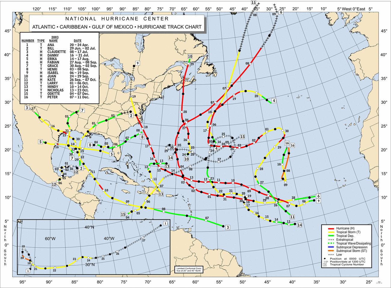
One of the more recent Hurricane remnants to affect the area was Isabel, which moved quickly through the Eastern Great Lakes on September 18-19th, 2003. Rainfall from the system was quite variable ranging from just a trace over far western areas of Southeast Michigan, to as much as 2 1/2 inches at local spots along the St. Clair River.

The Astonishing Storm of September 25th, 1941

Earlier, I mentioned "one storm that screams for attention", but maybe "howls" would be more appropriate. Before researching this project, I expected to find the above case scenarios, but not the following...

A tropical storm (#2) formed in mid September over the eastern Gulf of Mexico (off the coast of Florida) on September 17th, 1941. It pushed west across the Gulf, stopping only to make a loop in its track, well south of New Orleans. By this time it was a hurricane, intensifying briefly to a category #3 storm (111-130 mph wind) offshore as it took aim on eastern Texas. The hurricane made landfall on the 23rd near Freeport, Texas with an estimated wind of 110 mph, extremely high tides of nearly 11 feet and a barometer reading of 28.31 inches (959 MB). Further to the northeast, a ship just offshore of Texas City recorded a lowest pressure of 28.66 inches and winds of 83 mph. Other wind gusts were estimated near 100 mph at several locations near the hurricane's center along the Texas Gulf Coast. The hurricane quickly weakened to a category #1 (74-95 mph) as it made landfall and by the time the storm pushed on north to Houston, wind gusts had already dropped to 75 mph. Four lives were lost from the storm in Texas and property damage was estimated at $6.5 million (1941 dollars).

The storm continued to roar on its northward path through Texas and by 7 am on the 24th, it was located near the city of Tyler, over extreme northeast Texas. From this point on, the storm's last 36 hours or so really grabs ones interest for peculiarity as it tracked through the Mississippi Valley and on into the Great Lakes. From 7AM on the 24th to 7am the 25th, the storm shot northeast from Tyler to near Battle Creek, Michigan, covering close to 1000 miles in 24 hours! Thus, the forward movement of the remnants of the hurricane averaged 40 to 45 mph as it approached Southern Lower Michigan. As the storm tracked into the Great Lakes, it merged with a fairly strong cold front that pushed across the upper Midwest into the Lakes. The combination of the strong push of cool fall air, strong upper level dynamics and the remnants of the hurricane created quite a storm (not unlike the more common intense late fall cyclones that are seen in the Great Lakes). In addition, the track and speed of our "hurricane" brings to mind that of the "Panhandle Low" type of low pressure system in the winter (more information). While the speed of the system was fairly quick, it's not uncommon for hurricanes to accelerate northeast as they become extratropical and get "picked up" by the mid-latitude upper winds or jet stream. Yet, what was really unusual and noteworthy was the surface wind that accompanied the storm as it moved through the Great Lakes. By the time hurricanes make it this far north, they usually have blown themselves out, at least to the extent that surface winds are only gusting to, at best, 30 or 40 mph. Note the following, taken from the Detroit weather records on September 25th, 1941:

Windstorm: An intense tropical cyclone moving up from the Gulf thru eastern Texas (causing great damage in Texas), along the Missip. Valley and thence Newd across Ill & Mich, passing W & NW of Detroit with gale force winds and gusts to 65 mph from 10:18 AM - 2:30 PM & gusts to 75 mph 12:30 PM - 2:00 PM (see envelope back of book for newspaper clippings).

Most of the above noted news clippings show widespread wind damage to trees and power lines that would be commonplace in severe thunderstorms or a derecho. A derecho is a widespread windstorm consisting of a complex of thunderstorms that develop into a long-lived squall line. But there also were some unusual or freakish happenings (as the Detroit Free Press deemed them) as well. The following is taken September 26th, 1941, the day after, from the Detroit Free Press about the storm:

"River goes dry"

There were many freakish effects of the wind, including baring of the
Detroit River "middle grounds" off Belle Isle when water was backed into Lake St. Clair. The southwest gale literally blew the water out of The Detroit River, reducing its level by three feet, and leaving hundreds of pleasure craft high and dry on the muddy bottom. Several yachts broke their mooring or were heeled over at the Detroit Yacht Club. Another odd effect was the noticeable swaying of Downtown skyscrapers as the full force of the gale struck. Office employees who left tall downtown skyscrapers, were later reassured by engineers.

The Free Press goes on to say that "shortly after noon, the wind blew steadily at 56 miles an hour, but a times gusts reached hurricane velocity of 75 miles an hour." Dozens of people were injured by falling glass from windows blown out or debris tossed by the wind. One woman was literally blown into a fire hydrant, suffering a possible skull fracture. Other reports of scattered damage to homes and businesses across the region were mentioned in the article. In addition, the fierce wind churned up giant waves on the Lakes, including Lake Huron into the St. Clair River where two barges were blown ashore from of the shipping channel, even after dropping their heaviest anchors. In Southeast Lower Michigan, Storm Warnings were posted on Lakes Huron, Erie and St Clair at 10:30, the morning of the 25th. Downed telephone lines caused a disruption of service and communication across the Great Lakes and elsewhere. The "dying" hurricane left a trail of damage from Texas clear up into the Great Lakes and Canada. The wind of the storm was equated to an intense fall low pressure system that hit the area on November 29th, 1919 in which the wind blew 67 mph in Detroit and to the "Black Friday" storm in November of 1913.

The fact that the hurricane, after weakening and becoming extratropical, traveled over a thousand miles and still was able to maintain that much wind is extraordinary in itself. As the storm moved into Southern Lower Michigan, its center tracked northeast across Battle Creek, Lansing, Saginaw and then out over Lake Huron and into Ontario. Judging by the lowest pressure readings at Detroit (29.25 inches) and Flint (29.17 inches), where the wind gusted to 69 mph, its central pressure was estimated to around 29.10 inches (about 985 MB). Quite impressive for the remnants of a "dying" hurricane in the Great Lakes in September. In fact, this is the second lowest pressure reading ever recorded in Detroit during the month of September (the first being 29.21 inches on Sep 29th, 1966, during the passage of an intense early fall low pressure system).

One can only make a random guess as to the chances of another hurricane-force wind storm, from remnants of an actual hurricane, hitting the Great Lakes again. Since it was the only one of its kind in the record books at Detroit since records began in 1870, it may take several 100 years before another similar storm affects the region!

Hurroncane

One final, extremely interesting "hurricane" that affected the Great Lakes must be mentioned to make this article complete. While this storm was not from remnants of a tropical system, its development over Lake Huron had many uncanny likenesses to tropical systems...

The first likeness was its timing, forming over the Great Lakes right at the height of the typical hurricane season, September 11-15th, 1996. What started as a typical core-cold 500 MB low pressure system evolved into a warm-core system as it settled over the relatively warm waters of the Great Lakes, in particular, Lake Huron. The low pressure system actually had moved past Lake Huron but then retrograded, or was "drawn back", to the relatively warm waters of Lake Huron. (Similar to the tropics, the Great Lakes usually reach their warmest water temperatures late August into mid September.) The storm then deepened and intensified at the lower levels of the atmosphere compared to aloft, typical of a warm-core low. It is believed that the warm waters of Lake Huron and associated low level instability over the lake were, to a large extent, the major contributing factors in this storm's evolution. The storm went on to form a broad cyclonic circulation, including the "spiral bands and eye", typically seen in hurricanes! At one point, the cyclone produced tropical storm force winds (39 - 73 mph) and some of the spiral bands even had rainfall exceeding 10 cm (better than four inches), causing some flooding.

On satellite, the storm looked very much like the classic hurricane picture:


This "Hurroncane" reached its maximum intensity during the day on September 14th, when a central pressure of 29.34 inches (993 MB) was recorded in the late morning by a Lake Huron buoy that fortunately was positioned, at one point, in the "eye". By 2 PM, that "eye" measured close to 20 miles across and had a ring of tall convective clouds surrounding it, strongly resembling that of an "eye wall". The convective showers encircled the "eye" well out over 300 miles. As the "eye" moved to the southwest (retrograded), over the aforementioned buoy, the surface wind backed from west at close to 35 mph to the southeast, and then diminished to near 10 mph. After, the "eye" continued to track to the southwest, away from the buoy, and the surface wind backed further to the northeast, and briefly attained tropical storm force. A similar scenario but with varying wind speeds, would also be expected at the ocean's surface if a tropical system retrograded from northeast to the southwest overhead. In addition, the air temperature rose from 13°C (55°F) in the spiral shower bands, to near 18°C (64°F), which was also the lake temperature, in the clearing above the "eye". The storm weakened overnight as the lake temperature dropped 5°C (9°F). The lower water temperature helped greatly in weakening the storm as a result of the lower latent heat supply.

For additional information on hurricanes, check in with the
National Hurricane Center.

Background on "Hurroncane" was provided by a paper entitled "Hurricane Huron" by Mr. Todd Miner of Pennsylvania State University along with Dr. Peter Sousounis, Dr. Greg Mann and Mr. James Wallman of the University of Michigan.


Making weather fun while we all learn,
Bill Deedler - SEMI_WeatherHistorian


Sep 13, 2012

Update 9/24 - Round Two of Coldest Morning's Verification


9/24
Another cold night leaves temperatures solidly in the 30s along with areas of frost and isolated areas of freezing temperatures. Readings fell mainly into the mid 30s with lowest temperatures around 30 and highest around 40. While temperatures fell close to records, no record lows were set at Detroit, Flint nor Saginaw. The closest breach was Flint with a low of 34 and record of 31/1989. Detroit fell to 37 with a record of 33/1989 and Saginaw fell only to 38 with a record of 30/1950.

Repeating;
Monday morning should be the last in this episode of cold weather for the time-being as the rest of the week looks milder. While temperatures will rebound somewhat during the week; overall readings will still range from cooler than normal to near normal. Normal highs across Southeast Michigan during the last week of September average in the mid 60s to near 70; while lows fall into the mid 40s to near 50.

000
ASUS63 KDTX 241534
RTPDTX
MORNING TEMPERATURE AND PRECIPITATION SUMMARY
NATIONAL WEATHER SERVICE DETROIT/PONTIAC MI
1134 AM EDT MON SEP 24 2012

VALUES REPRESENT YESTERDAY`S HIGHS....LOW OVER THE LAST 12 HOURS
AND PRECIPITATION OVER THE LAST 24 HOURS ENDING AT 8 AM EDT


.BR DTX  0924  ES DH00/TAIRZX/DH07/TAIRZP/TA/PPDRZZ


:SOUTHEAST MICHIGAN -- TEMPERATURE AND PRECIPITATION STATIONS
:.......................................................
:       STATION              MAX / MIN  / 8 AM  / 24-HR
:        NAME                TEMP/ TEMP / TEMP  / PRECIP
:.......................................................
WHKM4: NWS WHITE LAKE      :   54 /  33  /  38  / 0.01
ARBM4: ANN ARBOR           :   57 /  37  /  38  /    T
ADG  : ADRIAN AIRPORT      :   58 /  36  /  37  / 0.00
BAX  :*BAD AXE AIRPORT     :   54 /  33  /  39  /
CFS  :*CARO AIRPORT-TUSCOLA:   55 /  32  /  36  /
DET  : DETROIT CITY AIRPORT:   58 /  39  /  41  / 0.00
DTW  : DETROIT METRO ARPT  :   59 /  37  /  39  / 0.00
FNT  : FLINT BISHOP AIRPORT:   57 /  34  /  41  / 0.02
ONZ  :*GROSSE ILE AIRPORT  :   59 /  43  /  46  /
OZW  :*HOWELL AIRPORT      :   57 /  37  /  41  /
DUH  :*LAMBERTVILLE AIRPORT:   60 /  36  /  39  /
D95  :*LAPEER DUPONT AIRPRT:   54 /  32  /  39  /
IKW  :*MIDLAND AIRPORT     :   55 /  30  /  36  /
TTF  :*MONROE AIRPORT      :   57 /  36  /  37  /
RNP  :*OWOSSO AIRPORT      :   58 /  39  /  45  /
PTK  : PONTIAC AIRPORT     :   56 /  37  /  38  / 0.00
P58  : PORT HOPE           :   56 /  40  /  41  / 0.02
PHN  :*PORT HURON AIRPORT  :   54 /  30  /  36  /
MBS  : SAGINAW - TRI-CITIES:   58 /  38  /  39  / 0.01
HYX  :*SAGINAW-HARRY BROWNE:   57 /  37  /  41  /
VLL  :*OAKLAND/TROY AIRPORT:   58 /  40  /  42  /
YIP  : YPSILANTI WILLOW RUN:   60 /  37  /  39  / 0.01
.END


*THE TEMPERATURE DATA FOR THESE SITES ABOVE REPRESENT THE HIGHEST AND
 LOWEST TEMPERATURES THAT WERE REPORTED ON THE METAR OBSERVATIONS
 THAT TRANSMIT THREE TIMES AN HOUR AND MAY NOT REPRESENT THE ACTUAL
 HIGH OR LOW FOR THAT SITE. THESE SITES DO NOT MEASURE
 PRECIPITATION.
.....................................................................


THE FOLLOWING COOPERATIVE OBSERVER SITES REPORT FROM MIDNIGHT TO
MIDNIGHT THE PREVIOUS DAY.


.BR DTX  0924  ES DH07/TAIRZX/TAIRZN/TA/PPDRZZ


:SOUTHEAST MICHIGAN -- TEMPERATURE AND PRECIPITATION STATIONS
:.......................................................
:       STATION               MAX / MIN  / 12 AM /24-HR
:        NAME                 TEMP/ TEMP / TEMP  /PRECIP
:.......................................................
ARNM4: ADRIAN              :   57 /  39  /  40  / 0.00
MILM4: MILFORD - GM GROUNDS:   57 /  40  /  41  / 0.03
MDLM4: MIDLAND             :   57 /  39  /  42  /    T
MTC  : MT CLEMENS SELFRIDGE:    M /   M  /  41  /    M
SGNM4: SAGINAW 5W          :   56 /  38  /  39  / 0.01
.....................................................................


COOPERATIVE OBSERVATIONS VALUES ARE FOR APPROXIMATELY THE PREVIOUS 24
HOURS FROM YESTERDAYS OBSERVATION TIME TO TODAY`S OBSERVATION TIME.


.BR DTX  0924  ES DH07/TAIRZX/TAIRZN/TA/PPDRZZ


:SOUTHEAST MICHIGAN -- TEMPERATURE AND PRECIPITATION STATIONS
:.........................................................
:       STATION            OB   /MAX / MIN  / OB   /24-HR
:        NAME              TIME /TEMP/ TEMP / TEMP /PRECIP
:.........................................................
: ***MIDLAND COUNTY***


: ***BAY COUNTY***
AUBM4:  AUBURN            :0630/   51 /  33  /  35  / 0.00


: ***HURON COUNTY***
BDAM4:  BAD AXE           :0700/   56 /  37  /  37  / 0.02
FLNM4:  FILION 5NNW       :0620/   54 /  37  /  37  / 0.01
POAM4:  PORT AUSTIN       :0740/   55 /  38  /  39  / 0.10
PHPM4:  PORT HOPE         :0800/   55 /  38  /  42  / 0.01


: ***SAGINAW COUNTY***
CHSM4:  CHESANING         :0730/      /      /      /0.01
MERM4:  MERRIL 2E         :0800/   57 /  35  /  39  /    T
SAGM4:  SAGINAW           :0800/   59 /  37  /  37  /    T


: ***TUSCOLA COUNTY***
CARM4:  CARO              :0730/   55 /  37  /  38  / 0.03
VSSM4:  VASSAR            :0700/   58 /  31  /  32  /    T


: ***SANILAC COUNTY***
LEXM4:  LEXINGTON         :0745/   57 /  37  /  39  / 0.00
MRLM4:  MARLETTE          :0700/   54 /  37  /  38  / 0.00


: ***SHIAWASSEE COUNTY***
CORM4:  CORUNNA 2NE       :0600/   59 /  38  /  38  / 0.02
DRNM4:  DURAND            :0800/   57 /  38  /  42  / 0.02
OWSM4:  OWOSSO            :0700/   57 /  36  /  39  / 0.07


: ***GENESEE COUNTY***
BUNM4:  BURTON 4N         :0700/   59 /  33  /  34  / 0.03
FLTM4:  FLINT  7W         :0800/   56 /  36  /  40  /    T
GODM4:  GOODRICH          :0730/   57 /  36  /  38  / 0.03


: ***LAPEER COUNTY***
LPEM4:  LAPEER 2W         :0910/   57 /  36  /  46  /    T
LPRM4:  LAPEER            :0730/   55 /  36  /  39  / 0.03


: ***ST. CLAIR COUNTY***
AGCM4:  ALGONAC           :M   /    M /   M  /  43  / 0.00
YALM4:  YALE              :0655/   58 /  37  /  37  / 0.00


: ***LIVINGSTON COUNTY***
HELM4:  HELL              :1015/   57 /  35  /  53  / 0.02
HOWM4:  HOWELL            :0745/   58 /  32  /  34  / 0.00


: ***OAKLAND COUNTY***
FARM4:  FARMINGTON        :0730/   58 /  35  /  35  / 0.05
PONM4:  PONTIAC           :0808/   55 /  39  /  43  / 0.00
WSBM4:  WEST BLOOMFIELD   :0730/      /       /     / 0.00


: ***MACOMB COUNTY***
RICM4:  RICHMOND 4NNW     :0815/   58 /  33  /  36  / 0.00


: ***WASHTENAW COUNTY***
AASM4: ANN ARBOR-SOUTHEAST:0730/   58 /  34  /  35  / 0.01
AAWM4:  ANN ARBOR 1W      :0830/   58 /  38  /  48  / 0.00
CHLM4:  CHELSEA           :0926/   57 /  34  /  47  /    T
MCHM4:  MANCHESTER        :0638/   59 /  35  /  35  /    T
SLNM4:  SALINE 4SW        :0800/   60 /  31  /  34  / 0.00
SALM4:  SALINE            :0800/   53 /  30  /  32  / 0.00


: ***WAYNE COUNTY***
DBNM4:  DEARBORN          :0500/   60 /  40  /  40  / 0.00
GPFM4:  GROSSE PTE FARMS  :0800/   58 /  39  /  42  / 0.00
WYTM4:  WYANDOTTE         :0800/      /       /     /    T


: ***LENAWEE COUNTY***
BLIM4:  BLISSFIELD 1SW    :0630/   58 /  33  /  34  /    T
MRIM4:  MORENCI           :0730/   60 /  33  /  34  / 0.00
TECM4:  TECUMSEH          :0630/   60 /  35  /  37  / 0.02
TIPM4:  TIPTON 2WNW       :0800/   60 /  34  /  35  / 0.01


: ***MONROE COUNTY***
DNDM4:  DUNDEE            :0720/   59 /  36  /  36  / 0.04
MLIM4:  MILAN             :0815/   57 /  35  /  37  / 0.03
MNRM4:  MONROE            :0730/   59 /  34  /  34  / 0.00
NWPM4:  NEWPORT 4SSE      :0600/   61 /  37  /  39  / 0.00

---------------------------------------------------------------------------------------------------------

9/23
The second wave of unseasonably cold air initially mentioned in my write up way back on 9/13 is now over the region and does pose the risk of some frost and freezing temperatures across Southeast Lower Michigan. This is the second and more potent of the two cold air masses to move over the region this past week and is now settling over the region. The air mass does have the capability of producing areas of frost and freezing temperatures; especially in the advent of clearing skies and lighter winds. Record lows Monday morning are genrally in the lower 30s; with 33 at Detroit, 31 at Flint and 30 at Saginaw. While the Detroit area, including Metro Airport, appear safe from breaking the record low of 33; regions away from the city into rural areas of Southeast Michigan do run the risk of temperatures falling as low from around 30 to the mid 30s (which includes Flint and Saginaw). On the warmer side of things; areas under patchy clouds, near and/or in cities, lakes and woods have the least likely risk of frost or freeze overnight.

Monday morning should be the last in this episode of cold weather for the time-being as the rest of the week looks milder. While temperatures will rebound somewhat during the week; overall readings will still range from cooler than normal to near normal. Normal highs across Southeast Michigan during the last week of September average in the mid 60s to near 70; while lows fall into the mid 40s to near 50.

Gardeners, nursery and landscape owners including other outside interests should be aware of the risk of a frost or freeze on tender, susseptible plants toight. Watering plants late this eveing or overnight may help in keeping warmer temperatures near ground level and cut down the risk of damage should frost or freeze develop in your area.

Making weather fun while we all learn,
Bill Deedler -SEMI_WeatherHistorian

-------------------------------------------------------------------------------------------------------------------------

Update 9/19
It was a cold morning across Southeast Lower Michigan with some areas coming within a degree or two from their records. Detroit Metro Airport fell to 39 /record 38/ while the rest of the region ranged from the mid 30s to mid 40s. However; Midland Airport did fall to 31 degrees for the coldest spot across the region.

MORNING TEMPERATURE AND PRECIPITATION SUMMARY
NATIONAL WEATHER SERVICE DETROIT/PONTIAC MI
923 AM EDT WED SEP 19 2012

VALUES REPRESENT YESTERDAY`S HIGHS....LOW OVER THE LAST 12 HOURS
AND PRECIPITATION OVER THE LAST 24 HOURS ENDING AT 8 AM EDT


.BR DTX  0919  ES DH00/TAIRZX/DH07/TAIRZP/TA/PPDRZZ


:SOUTHEAST MICHIGAN -- TEMPERATURE AND PRECIPITATION STATIONS
:.......................................................
:       STATION              MAX / MIN  / 8 AM  / 24-HR
:        NAME                TEMP/ TEMP / TEMP  / PRECIP
:.......................................................
WHKM4: NWS WHITE LAKE      :   61 /  34  /  37  /    T
ARBM4: ANN ARBOR           :   65 /  42  /  42  / 0.08
ADG  : ADRIAN AIRPORT      :   65 /  36  /  39  / 0.12
BAX  :*BAD AXE AIRPORT     :   63 /  36  /  38  /
CFS  :*CARO AIRPORT-TUSCOLA:   62 /  33  /  35  /
DET  : DETROIT CITY AIRPORT:   66 /  41  /  43  / 0.06
DTW  : DETROIT METRO ARPT  :   67 /  39  /  41  / 0.06
FNT  : FLINT BISHOP AIRPORT:   64 /  35  /  40  / 0.03
ONZ  :*GROSSE ILE AIRPORT  :   68 /  45  /  46  /
OZW  :*HOWELL AIRPORT      :   64 /  40  /  43  /
DUH  :*LAMBERTVILLE AIRPORT:   66 /  38  /  42  /
D95  :*LAPEER DUPONT AIRPRT:   64 /  36  /  38  /
IKW  :*MIDLAND AIRPORT     :   62 /  31  /  33  /
TTF  :*MONROE AIRPORT      :   66 /  37  /  41  /
RNP  :*OWOSSO AIRPORT      :   65 /  38  /  44  /
PTK  : PONTIAC AIRPORT     :   63 /  40  /  42  / 0.00
P58  : PORT HOPE           :   65 /  42  /  43  / 0.01
PHN  :*PORT HURON AIRPORT  :   64 /  36  /  37  /
MBS  : SAGINAW - TRI-CITIES:   64 /  37  /  38  / 0.03
HYX  :*SAGINAW-HARRY BROWNE:   64 /  37  /  41  /
VLL  :*OAKLAND/TROY AIRPORT:   66 /  43  /  44  /
YIP  : YPSILANTI WILLOW RUN:   68 /  38  /  40  / 0.05
.END


*THE TEMPERATURE DATA FOR THESE SITES ABOVE REPRESENT THE HIGHEST AND
 LOWEST TEMPERATURES THAT WERE REPORTED ON THE METAR OBSERVATIONS
 THAT TRANSMIT THREE TIMES AN HOUR AND MAY NOT REPRESENT THE ACTUAL
 HIGH OR LOW FOR THAT SITE. THESE SITES DO NOT MEASURE
 PRECIPITATION.
.....................................................................


THE FOLLOWING COOPERATIVE OBSERVER SITES REPORT FROM MIDNIGHT TO
MIDNIGHT THE PREVIOUS DAY.


.BR DTX  0919  ES DH07/TAIRZX/TAIRZN/TA/PPDRZZ


:SOUTHEAST MICHIGAN -- TEMPERATURE AND PRECIPITATION STATIONS
:.......................................................
:       STATION               MAX / MIN  / 12 AM /24-HR
:        NAME                 TEMP/ TEMP / TEMP  /PRECIP
:.......................................................
ARNM4: ADRIAN              :   65 /  44  /  44  / 0.14
MILM4: MILFORD - GM GROUNDS:   64 /  42  /  42  / 0.06
MDLM4: MIDLAND             :   65 /  42  /  42  / 0.09
MTC  : MT CLEMENS SELFRIDGE:    M /   M  /  43  /    M
PRHM4: PORT HURON          :   68 /  49  /  49  / 0.03
SGNM4: SAGINAW 5W          :   63 /  42  /  43  / 0.08
.....................................................................


COOPERATIVE OBSERVATIONS VALUES ARE FOR APPROXIMATELY THE PREVIOUS 24
HOURS FROM YESTERDAYS OBSERVATION TIME TO TODAY`S OBSERVATION TIME.


.BR DTX  0919  ES DH07/TAIRZX/TAIRZN/TA/PPDRZZ


:SOUTHEAST MICHIGAN -- TEMPERATURE AND PRECIPITATION STATIONS
:.........................................................
:       STATION            OB   /MAX / MIN  / OB   /24-HR
:        NAME              TIME /TEMP/ TEMP / TEMP /PRECIP
:.........................................................
: ***MIDLAND COUNTY***


: ***BAY COUNTY***
AUBM4:  AUBURN            :0630/   63 /  33  /  38  / 0.01


: ***HURON COUNTY***
BDAM4:  BAD AXE           :0700/   77 /  41  /  41  / 0.02
FLNM4:  FILION 5NNW       :0620/   60 /  39  /  39  / 0.09
POAM4:  PORT AUSTIN       :0740/   59 /  42  /  42  / 0.03
PHPM4:  PORT HOPE         :0800/   57 /  40  /  41  / 0.06


: ***SAGINAW COUNTY***
CHSM4:  CHESANING         :0730/      /      /      /0.03
SAGM4:  SAGINAW           :0800/   62 /  38  /  39  / 0.00


: ***TUSCOLA COUNTY***
CARM4:  CARO              :0745/   61 /  37  /  39  / 0.00
VSSM4:  VASSAR            :0700/   60 /  35  /  35  / 0.03


: ***SANILAC COUNTY***
LEXM4:  LEXINGTON         :0710/   61 /  39  /  39  / 0.05
MRLM4:  MARLETTE          :0640/   61 /  38  /  38  / 0.01
SANM4:  SANDUSKY          :0647/   60 /  39  /  39  /    T


: ***SHIAWASSEE COUNTY***
CORM4:  CORUNNA 2NE       :0600/   63 /  38  /  38  /    T
DRNM4:  DURAND            :0800/   61 /  39  /  42  / 0.00
OWSM4:  OWOSSO            :0700/   60 /  38  /  39  / 0.04


: ***GENESEE COUNTY***
BUNM4:  BURTON 4N         :0700/   62 /  35  /  35  / 0.03
FLTM4:  FLINT  7W         :0800/   60 /  37  /  39  / 0.01
GODM4:  GOODRICH          :0730/   61 /  37  /  38  /    T


: ***LAPEER COUNTY***
LPRM4:  LAPEER            :0730/   60 /  38  /  38  / 0.50


: ***ST. CLAIR COUNTY***
YALM4:  YALE              :0700/   62 /  37  /  37  / 0.03


: ***LIVINGSTON COUNTY***
HOWM4:  HOWELL            :0745/   62 /  35  /  36  / 0.03
WHLM4:WHITMORE LK 1N      :0700/   62 /  36  /  36  / 0.02


: ***OAKLAND COUNTY***
FARM4:  FARMINGTON        :0730/   63 /  38  /  38  / 0.04
WSBM4:  WEST BLOOMFIELD   :0700/      /       /     / 0.05


: ***MACOMB COUNTY***
RICM4:  RICHMOND 4NNW     :0900/   63 /  37  /  44  / 0.04


: ***WASHTENAW COUNTY***
AASM4: ANN ARBOR-SOUTHEAST:0730/   62 /  36  /  36  / 0.03
AAWM4:  ANN ARBOR 1W      :0830/   63 /  37  /  45  / 0.02
MCHM4:  MANCHESTER        :0433/   64 /  38  /  38  / 0.05
SLNM4:  SALINE 4SW        :0800/   65 /   M  /  36  / 0.05


: ***WAYNE COUNTY***
DBNM4:  DEARBORN          :0500/   66 /  42  /  42  / 0.03
GPFM4:  GROSSE PTE FARMS  :0815/   62 /  40  /  46  / 0.05
WYTM4:  WYANDOTTE         :0800/      /       /     / 0.16


: ***LENAWEE COUNTY***
BLIM4:  BLISSFIELD 1SW    :0705/   63 /  35  /  35  / 0.02
MRIM4:  MORENCI           :0730/   68 /  36  /  36  /    T
TECM4:  TECUMSEH          :0630/   65 /  38  /  40  / 0.01
TIPM4:  TIPTON 2WNW       :0800/   68 /  36  /  38  / 0.01


: ***MONROE COUNTY***
DNDM4:  DUNDEE            :0645/   64 /  38  /  38  / 0.02
MLIM4:  MILAN             :0756/   63 /  37  /  38  / 0.08
MNRM4:  MONROE            :0837/   65 /  36  /  42  / 0.01
NWPM4:  NEWPORT 4SSE      :0600/   67 /  39  /  39  / 0.02
SAMM4:  SAMARIA           :0735/   66 /  35  /  36  /    T
.END


* ALL DATA ABOVE IS PRELIMINARY AND HAS NOT UNDERGONE FINAL QUALITY
CONTROL BY THE NATIONAL CLIMATIC DATA CENTER /NCDC/.  THEREFORE...
THIS DATA IS SUBJECT TO REVISION.  FINAL AND CERTIFIED CLIMATE DATA
CAN BE ACCESSED AT WWW.NCDC.NOAA.GOV.


9/17
All systems are go on plunge of colder air this week; coming in two notable shots with a sharp moderation in-between. While the intensity of the cold and duration of the overall change in upper air pattern is impressive mimicking more mid October; the sharp temperature contrast are certainly reminiscent of Autumn which is slated to arrive Sep 22nd at 1049AM EDT on Saturday morning. The first cold front will bring sharply colder weather (Fig -1) Tuesday into early Wednesday; then a rebound in temperatures is slated before the next cold front blasts through Southeast Lower Michigan on Friday and; stays thru the weekend. At this time; it looks as though coldest of high temperatures will be generally in the 50s to lower 60s...with coldest of lows as low as the mid 30s to mid 40s across Southeast Lower Michigan. While some rural areas are likely to fall into the mid to upper 30s Wednesday morning; a widespread killing frost should be averted but with some patchy frost certainly possible. And again; I'm still looking for temperatures to generally range in the mid 30s to mid 40s across Southeast Lower Michigan Wednesday morning.

                                                                                       Fig - 1

After the rebound in temperatures later Wednesday and Thursday; the second main cold front (depicted in Fig-1 moving into the Dakotas) will be approaching the Great Lakes on Friday (Fig -2).


                                                                                          Fig -2

Finally by the first day of fall on Saturday afternoon; the Great Lakes and Southeast Lower Michigan will be deep in the throws of the Autumnal change. Exact timing of the fronts is still variable but general consensus is now somewhat more reliable. Get the rake handy; it won't be long now! ;-(

---------------------------------------------------------------------------------------------

Update - 9/14/12
It's beginning to become clearer as to the timing of the aforementioned strong cold fronts to blow through the region next week. The first cold front will bring sharply colder weather early Tuesday into early Wednesday; then a rebound in temperatures is slated before the next cold front blasts through Southeast Lower Michigan on Friday and; stays the weekend. At this time; it looks as though coldest of high temperatures will be generally in the 50s to lower 60s...with coldest of lows possibly as low as the mid 30s to mid 40s across Southeast Lower Michigan. The lows overnight are trickier since they will be largely dependent on sky cover and/or winds. While the infiltration of both cold air masses will be accompanied by strong gusty northwest winds; it's if there is clearing skies and lighter winds after the influx of colder air that would bring the coldest nights. As the time gets closer; will look at any particular day there may be the risk of frost or freeze especially since it's; 1- so early in the season and 2 - such an abrupt change for outdoor vegetation. Mother Nature certainly has not been kind to the plants and the growing season this spring and summer...and now this early cold snap will be a rude awakening! It's interesting to note that the record low maximums in Southeast Michigan during the period are generally in the lower to mid 50s; while record lows are in the mid to upper 30s for Detroit and lower to mid 30s for Flint and Saginaw.

Another impressive item on these early season cold surges is the duration it is expected to stick around. Latest guidance has the second punch in the one/two punch of cold air; sticking around well into early the following week (Mon 9/24-Tue 9/25 time frame). Ironically; the first day of fall will come on Saturday Sep 22nd, 2012 and this will be one time; one will not have to look at the calendar to find out the season upon us.


--------------------------------------------------------------------------------------------------------

Earlier Blog on this event:
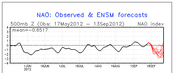
For days now, early indications are a strong upper level trough of much colder air will organize over central and eastern Canada as the North Atlantic Oscillation/Arctic Oscillation (NAO/AO) becomes decidedly negative (Fig - 1). The negative NAO/AO will instigate this troughing and colder air delivery to the Great Lakes. At this time; it appears these changes will commence early to mid week (Tue 9/18-Wed 9/19) time frame in the form of a few strong cold fronts that will surge through the region into late week.

                                                                                         Fig - 1

Of course at this early juncture; details of exact timing and intensity of the colder air remains to be seen but this time it appears it will be quite a change from the warm September we've become accustom to and bears watching; especially for outdoor garden and nursery enthusiasts! It is too early to say how cold it will get and if there's any risk of frost or freeze since it's so early in the season but thus far; I'm impressed on the model's cold air delivery. At times however; early cold outbreaks are handled poorly by meteorological models and thus, tend to be too aggressive but in any event; forewarned is to be forearmed if this does play out on the aggressive side. 

I'll keep tabs on this evolving event and update as it becomes clearer just how much of a change is in store for the Great Lakes and Southeast Lower Michigan. Autumn's official arrival doesn't happen until Saturday; September 22nd at 1049AM EDT but at this time it appears it will have plenty of fanfare BEFORE that date!

Making weather fun while we all learn,
Bill Deedler -SEMI_WeatherHistorian