6/21/22

Early Summer Upper Air Pattern Simulates Preferred Computer Guidance and Analogues as Calendar Summer Solstice Commences

The actual upper air and surface pattern during the month of June thus far has displayed well the expected pattern in my Summer Outlook based on analogues and prevailing computer guidance. The upper low winds prevailing over eastern Canada and upper ridge winds in varying positions over the States; have been oscillating in unison bringing cool and occasionally hot conditions into the Great Lakes. The north wind flow associated with the jet stream into the Canadian Upper Low has been exceptional resulting in a periodic push of cool, comfortable air with low humidity southeast, sometimes well into the eastern third of the country.

Just to recap the original Summer Outlook:

TEMPERATURES

I look for the summer to average around normal or -1.0 to +1.5 degrees of the new 1991-2020 normals in Southeast Lower Michigan. The summer seems to be shaping up to be a more changeable summer than is typical in both temperature ranges and weather patterns. The push of cooler air from Canada should offset most hotter spells from the south. 

RAINFALL

Though analogues display a slightly drier summer when all data is considered; in following the overall recent rainfall patterns, a normal to wetter summer is more likely.

As one can see; the CFS forecasted the upper prevailing height/wind pattern displayed below well for the beginning of the summer, anyway. From the Summer Outlook for Southeast Lower Michigan:


So what does the most recent upper level run display for the GFS 384hr run display for the U.S.? This pattern has been more or less forecasted into early July.


It is easy to see the persistence of the upper Low and associated troughs over Eastern Canada (and push of cooler air) into the Great Lakes and into the southeast while at the same time; breaks in the cooler pattern resulting of zonal to southwesterly flows of warm to hot weather behind the high pressure from the Plains and Midwest bringing hot, muggy air intermittently ahead of the next cold front.

Note; the surface pattern associated with the upper wind flow into early July. Warm to hot air masses are routinely dampened by varying intensities of cold fronts; weak to strong. Depending of strength of the cold front, available moisture and timing of day will create rainfall over the region and possible severe weather. Of course; this is just one run of the GFS but it contains the trend and does foretell the continuance of  current upper air pattern right through the July 4th weekend and beyond.


Up through the first three weeks of June and meteorological summer, temperatures have bounced from around normal to below - to above - and back below - and above erratically. Maybe not surprisingly temperatures have averaged close to normal all over Southeast Lower Michigan. In Detroit with an average of 69.0 degrees; the temperature is just three tenths above normal /0.3/ through the 20th. Flint's averaging 65.6 degrees or three tenths below normal /-0.3/; while Saginaw is at 66.7 /-0.2/. In addition; the Summer Solstice just occurred this morning; Tuesday, June 21, 2022, at 5:14 A.M. EDT.

To just give one an idea how erratic the temperatures have been over Southeast Lower Michigan; low temperature readings fell into the 40s and 50s over the weekend only to sharply rebound to near or at record highs today. Thus far today it looks like Detroit tied the 96 degree record of 96 back in 1933. On the flip-side, Flint fell to a record low Sunday morning of 43 - /old record of 44 - 1959/ and then popped to 95 degrees two days later today, Tuesday - /record still stands 98 in 1923/.

Making weather fun while we all learn,
Bill Deedler - SEMI_WeatherHistorian


6/5/22

Summer 2022 Outlook ~ A Typical Summer? Not

Summer of 2022 is shaping up to be a complex summer; weather-wise as the battle lines between the warm-hot muggy air and the prevailing cooler late spring-like air has only sporadically clashed in the Great Lakes thus far. I anticipate this will change soon like most years with the active part of summer only being pushed back a few weeks. Upper weather features create a strong, active jet with time as heat bubbles over the south and active fronts in the north.

TEMPERATURES

I look for the summer to average around normal or -1.0 to +1.5 degrees of the new 1991-2020 normals in Southeast Lower Michigan. The summer seems to be shaping up to be a more changeable summer than is typical in both temperature ranges and weather patterns. The push of cooler air from Canada should offset most hotter spells from the south.

RAINFALL

Though analogues display a slightly drier summer when all data is considered; in following the overall recent rainfall patterns, a normal to wetter summer is more likely. 

Global ENSO Patterns

Hemispherically speaking; the prevailing La Nina of the past several seasons shows little change through the summer into the autumn. In fact; latest forecast trends continues a weak La Nina into the fall anyway with questionable paths, thereafter. The upcoming winter would be our third La Nina winter if it remains so, an unusual occurrence. This is the very latest ENSO plot of various SST modeling as of June 5th.


Upper Wind/Pressure Height Outlook


PROJECTED UPPER WIND FLOW ACROSS THE COUNTRY FOR THE SUMMER

Many times the CFSv2 model displays similar pressure outlooks for the summer with the Upper Low over Eastern Canada and High Pressure ridging from the Midwest west to the Rockies. Their positioning and jet stream will be even more important this summer as there's been more of a dominance of the Upper Low in central-Eastern Canada and just recently; the Upper High ridging in the south and central US. The temperature contrast forecast has been quite notable and erratic for early - mid June on the GFS/CFS at times. For example; one run may be forecasting lows/highs 40s-60s across the Great Lakes mid month; then the next run; 70s to as high as mid 90s to around 100 for the very same area/period. The primary variance is a result of model setting up a rather deep cool trough over Eastern Canada/Great Lakes or a powerful warm-hot ridge over the same region and same time. 

With early modeling so erratic even in the short term; a good place to compare it to is the second summer weak La Nina analogues. And maybe not surprising; the analogues recently have some of our recent hottest summers 2012 and 2018 and earlier; some of our coolest summers. 1985, 1917. What to do?


With the older analogues being cooler along with new norms being slightly higher; the analogues are already skewed to cooler side. On the flip-side; the later years have indeed warmed slightly due to climate change and the warming of micro-climate at Detroit Metro Arpt due to urban and local airport expansion - all affecting temperatures since mainly the 1980s. These warming caveats must be considered in forecasting and outlooks at least for the Detroit Metro region.

The analogues since 2000 /4/ are more heavily weighted due to recent changes and patterns. Looking at those four specifically we have: two cool and two warm along with one summer wet, one dry and two around average rainfall - which btw has also risen /.14/ or from 9.89  to 10.03". Therefore; the later years still balance temperature and rainfall out to around the "new normals" - so not much help.๐Ÿ˜•

Taking all analogues into account spells a cooler than normal summer along with about normal to slightly below rainfall. But again; remember some of those "cooler" summers were actually normal summers at that time since the normals were cooler back then too, confused?  Normals are updated every decade to account for recent trends; much like I weighted the last 21 years in my analogues.

Analogue Monthly Trends

Temps

Monthly trends are very mixed but still are worth mentioning. Junes tended to be the coolest relative to normal when all analogues are considered. While all Julys and Augusts means also averaged below normal, using the recent trends /since 2000/ June and July have the best chance to counter that long-term trend by averaging normal to above. So for example; the long term prevailing guidance says a cooler June; while the short term analogue trend says a normal to warmer June๐Ÿ˜Ž

Rainfall

What's also interesting on these analogues is the mix of rainfall and when. And also where the median precipitation line falls...just below normal. That may be a hint of "who" dominates; the Upper Canadian Low or the American High Pressure Ridge. Since cooler and drier dominates the analogues entirely; that would suggest the Upper Low is able to help stir cooler, drier high pressures into the country more often than what typically happens.

It also should be noted; the two wettest years contained normal temperatures /1975/ - (which btw was rather stormy- parade of cold fronts). I started to work those mid 70s  and I do remember the mid 70s were active, especially 1974, 75 & 76. The other wet year was 2000 and boy was it a wet, cool summer. One of the wettest analogues I can recall with nearly 15" /about 5" above normal/ at DTW. I believe the northern/western burbs received more yet! These summers were active with fronts hanging around and battles of air masses breaking out.

More recent analogues hint at the ridge dominating which brought hot weather but actually less rainfall. If the ridge does dominate more; most of the active weather could be stirred further north across the northern Mississippi Valley, Great Lakes or Canada. Another possibility was the timing of the frontal activity with more fronts passing through Southeast Michigan late overnight into the forenoon hours leading to less rain. The busiest month in Southeast Michigan those hot summers was July in both 2012 and 2018.


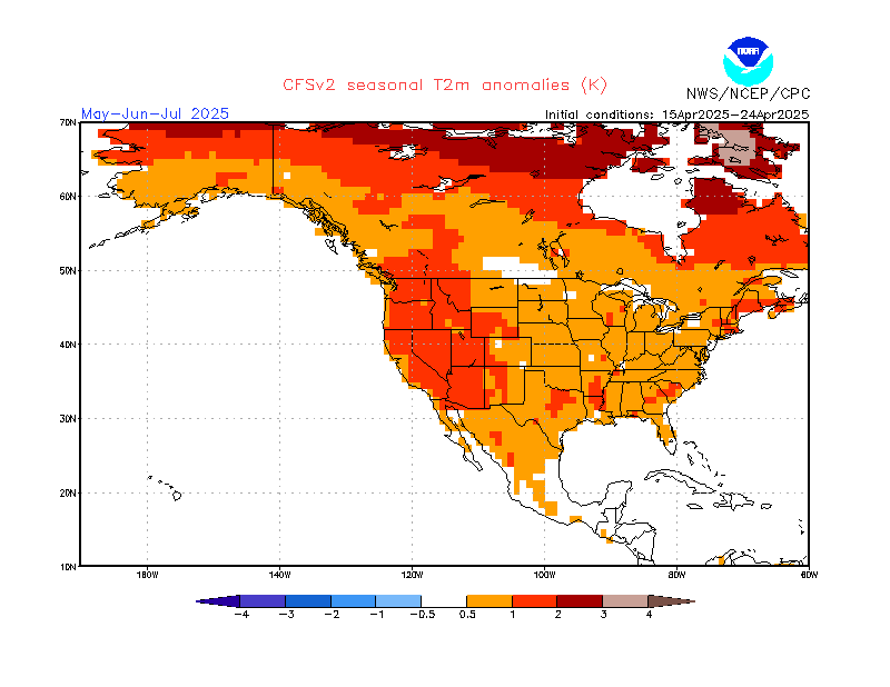
CFSv2 Temps Summer 2022

https://www.cpc.ncep.noaa.gov/products/CFSv2/imagesInd3/usT2mSeaInd1.gif 


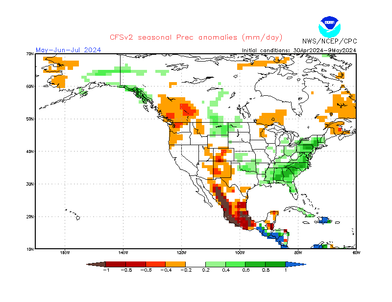
Rainfall Summer 2022

 https://www.cpc.ncep.noaa.gov/products/CFSv2/imagesInd3/usPrecSeaInd1.gif

Look for updates and other weather information on FB and here during the summer.

Making weather fun while we all learn,
Bill Deedler - SEMI_WeatherHistorian


6/1/22

Winter of 2021-22 Mostly Agreed With The Preferred Winter Outlook ~

First Off: Spring Backward ~

Another relatively later spring with extended cool periods held back our spring green up in spite of ample winter and spring snow and rains. Routine notable cold snaps into May pushed back the surge of spring green-up until late April - early May. In April (see Map below) into early May; shows temperatures averaging below normal and rainfall about average for the entire region with recent wetter conditions over the southern areas. The wetter conditions have been focused more around Metro Detroit, south to the Ohio border - not unlike the winter where Flint; south into Ann Arbor and Metro Detroit to the Ohio border saw normal to above snow (review of the Winter of 2021-22 is below). April's temperature pattern reflects the cooler spring since early April into early May. The coldest late spring stretch relative to normal was the last week of April when overnight lows fell around freezing or lower. Latest snowfall's all occurred later in April - on the 19th /T/ at Detroit, 27th /T/ at Flint and 26th /T/ in Saginaw.


A good way to look at this spring is the "growing degree days' since 4/1 versus average or normal. Thus far we are behind but made up some of the deficit in May.


Winter and Cold Season 2021-22 in Southeast Lower Michigan

November

The Winter of 2021-22 started early once again with some decent autumn snowfalls (given the actual season) in November. First snow flurries occurred just after Halloween on November 1st at Flint and Saginaw and 2nd in Detroit.  Low pressure systems pushing through the Southern Great Lakes Thanksgiving weekend, to a large extent, made November in Detroit the 15th snowiest November /tying with 1972/ with 7.1". Further north; Flint received 5.9" for the month just missing the top 20 snowiest while Saginaw received the least at 2.6". 

December

The Climatological /Dec - Jan/ Winter of 2021-22 all in all was a rather uneventful winter with near normal temperatures and snowfall across Southeast Lower Michigan.

However; as one might have expected with the snowfalls and cold in November, especially south, the cold and snowy winter was just getting started. So then, winter started with a bang? Nope. December, just it's done the past few years, reversed course and a notable mild pattern held for much of the month. The average temperature at Detroit came in at 37.2 degrees; a significant 5.9 degrees above normal and just 2.2 degrees cooler than November's 39.4 Add to that just 3.8" of snow and December was really more like another November. Flint's average at 34.4 came in 5.7 degrees above normal but still managed 10.6" of snow, about normal for December. Saginaw joined in the warmer December with an average temperature of 33.4; 4.5 above normal with normal snow of 9.6".

January

Real winter arrived (I swear winter months are actually Jan-Mar in these parts). Temperatures plummeted to an average 20.3 (after that 37.2 in December) in Detroit while snowfall just nicked slightly below normal at 8.8". Flint received more snow this month at 13.7" while temperatures averaged well below normal at 17.6 /-5.6/ which made the it the 17th coldest January in Flint. Saginaw averaged 17.9 /-5.1/ with 9.8". One of the notable snow events occurred on January 24th, 2022.

February

February's weather turned out to be the worst winter month as far as snow and cold with below normal temperatures and well above normal snow. Temperatures across the metro Detroit averaged 25-27 degrees with 26.4 /-1.6/ recorded at Detroit Metro Arpt. Snowfall doubled the normal average with 20.4" falling which easily made February the 14th snowiest in Detroit since 1881. True to form; Flint received the most snow as what was expected with the storms with 22.5" well over the normal of 11.8". Temperatures averaged normal at 24.5 /-0.2/. Saginaw's average temperature came in at 24.1 /-0.4/ with just 10.3"; notably lower that the other regions as expected in the Winter Outlook.  Many systems affected the region: Groundhog Day once again February 2nd; Locally; just before Valentines Day on Super Bowl Sunday in the western metro Detroit region; and the storm that formed and intensified in the northern Ohio Valley. 

March into spring

Early spring moderated a bit with normal to two degrees above normal temperatures (only to revert to below in April and early May to above later May) and slightly less snowfall (see intro above).

Winter Temperatures

Temperatures averaged slightly above normal for the Winter 2021-22 /Dec-Feb/ but that by far was only because of the exceptionally warm December (again); placing in the Top 20. This is another short term trend noted the past 20 years; Take a look...

Top 20 Coldest/Warmest Decembers in Southeast Lower Michigan
 
Rank Detroit Area* Flint Bishop** Saginaw Area***
Coldest Warmest Coldest Warmest Coldest Warmest
Temp Year Temp Year Temp Year Temp Year Temp Year Temp Year
1 17.8 1876 41.1 2015 16.1 1989 41.0 2015 16.2 1989 39.1 2015
2 18.0 1989 40.6 1881 16.6 2000 37.2 1982 17.2 2000 35.3 1923
3 19.2 2000 39.3 1889 17.4 1976 36.8 1923 18.8 1983 34.5 1982
4 20.8 1983 38.1 1877 17.8 1958 35.4 2006 18.9 1976 34.4 2006
5 21.5 1976 37.7 1923 20.1 1983 35.4 1965 19.0 1958 34.2 1931
6 21.8 1917 37.4 2006 20.5 1944 34.7 1931 19.1 1917 34.1 2012
7 21.9 1880 37.3 1982 20.8 1963 34.4 2021 19.5 1919 33.5 2001
8 22.2 1985 37.2 2021 21.3 1985 34.2 2019 20.1 1963 33.4 2021
9 22.4 1958 37.2 1931 21.7 1960 34.1 2001 21.0 1924 33.4 1941
10 22.5 1903 36.3 1918 22.2 1945 33.6 1941 21.3 1944 33.0 2011
11 22.8 1878 35.9 2012 22.4 1950 33.5 2012 21.5 1960 33.0 1965
12 23.0 1909 35.9 1965 22.6 2017 33.4 1984 21.6 1985 32.8 1936
13 23.1 1919 35.8 2001 22.9 1962 33.3 2011 22.0 1980 32.5 2019
14 23.2 1924 35.8 1891 23.0 1995 33.1 2020 22.0 1914 32.3 1994
15 23.3 1910 35.5 2011 23.1 1942 32.8 2014 22.2 1962 32.2 1913
16 23.8 1963 35.5 1941 23.2 1924 32.8 1939 22.4 1926 32.1 2014
17 23.8 1914 35.4 1994 23.9 1937 32.4 1971 22.5 1950 32.0 1998
18 23.9 1886 35.3 1998 24.0 1926 32.3 1998 22.5 1945 32.0 1918
19 24.7 1945 35.1 2019 24.3 2010 32.2 1987 22.5 1942 31.7 2020
20 24.8 1944 34.8 1956 24.3 2005 32.1 2003 22.8 2013 31.5 1959
* Detroit Area temperature records date back to January 1874.

** Flint Bishop temperature records date back to January 1921.

*** Saginaw Area temperature records date back to January 1912.

Going back to 1874 at Detroit; seven warmest Decembers have occurred in the 21st century; since 2000. Therefore; out of the Top 20 Warmest Decembers in Detroit, 35% have occurred since 2000. At Flint; 10 out of the 20 Warmest Decembers have occurred since 2000 - or 50%!  At Saginaw; nine out of 20 Warmest Decembers /45%/ have registered this century.

Winter Snowfall

The month of February was the snowiest month while December was the least. In fact; some places had more snow in November than December. A snowy February has certainly become more commonplace since 2000 across Southeast Lower Michigan. Detroit has seen 10 out of 20 snowiest Februaries this century already - or 50% have occurred since 2000.  However; it's also curious to note three of the Top 20 Snowless Februarys also occurred since 2000. Over at Flint; 11 out of the Top 20 Snowiest Februarys have also placed in the top 20 since 2000 and two snowless. While Saginaw has 10 snowiest Februarys this century it placed only one snowless.

Take a look...

Top 20 Snowiest/Snowless Februaries in Southeast Lower Michigan
 
Rank Detroit Area* Flint Bishop** Saginaw Area***
Snowiest Snowless Snowiest Snowless Snowiest Snowless
Total Year Total Year Total Year Total Year Total Year Total Year
1 38.4 1908 0.0 1998 31.7 2011 0.4 1998 34.2 2008 0.0 1987
2 31.7 2011 0.7 1953 29.7 2021 1.4 1992 29.4 2011 0.1 1984
3 28.4 1881 0.9 2004 29.4 2008 1.9 2017 23.4 1935 0.5 1998
4 28.0 1900 1.5 1895 22.7 2016 2.2 1987 22.2 2013 1.4 1983
5 27.6 1926 1.6 1906 22.5 2022 2.4 1953 20.3 1965 1.9 2017
6 27.0 2010 2.0 1987 21.8 2018 2.4 1937 20.0 1912 1.9 1977
7 26.4 2015 2.1 1882 21.8 2014 2.9 1969 19.8 1985 2.0 1932
8 24.2 2008 2.2 2017 21.2 2010 2.9 1943 18.6 1926 2.1 1980
9 23.5 2013 2.2 1915 20.8 1990 3.0 1979 18.4 1990 2.2 1947
10 23.4 2014 2.3 1969 20.6 1986 3.0 1934 18.3 2010 2.4 1942
11 21.8 2021 2.4 1992 20.1 1994 3.5 1945 18.1 2021 2.5 1969
12 21.0 2018 2.4 1937 19.7 1965 3.6 1984 18.0 2016 2.6 1928
13 20.8 1986 2.5 1966 19.6 1988 3.6 1938 18.0 2005 3.1 1995
14 20.4 2022 2.6 1891 18.8 2020 3.8 1977 17.7 1924 3.2 1919
15 19.6 1898 2.7 1943 18.3 1946 4.1 1928 17.5 1950 3.4 1958
16 19.2 2003 2.8 1968 17.4 2015 4.5 1957 17.1 1956 3.5 1963
17 19.2 1988 2.8 1925 17.2 1960 4.8 1983 17.0 2014 3.7 1957
18 18.0 1893 2.9 2001 17.0 1924 4.9 1932 17.0 2012 3.7 1917
19 17.1 1994 3.1 1949 16.7 1973 5.0 2001 16.2 2015 3.8 1913
20 16.9 1985 3.1 1919 16.6 2013 5.1 1921 16.2 1962 4.0 1964
* Detroit Area snowfall records date back to January 1880.
** Flint Bishop snowfall records date back to January 1921.
*** Saginaw Area snowfall records date back to January 1912.


https://mrcc.purdue.edu/cliwatch/GIS_plots/nohrsc/nohrsc_mrcc_seas.png


Winter Outlook Performance

Ironically; the Winter of 2021-22 played out similar to the Winter of 2020-21 as far as timing. Though the Winter of 2020-21 was milder than last winter it too had it's rough, snowier part in February. Our past winter contained a very mild, somewhat snowless December then it was all downhill as far as temperatures January into February. Snowfalls picked up in January and came full-boar in February in mainly the southern two thirds of Southeast Lower Michigan.

While Detroit received a slightly above normal snowfall at 47.1" /new 1991-2020 norm - 45"/; Flint received the highest total of the three climate stations with 60.5" /+8.4"/ over the new 1991-2020 norm 52.1". Saginaw's snowfall was the odd-man out and actually totaled well below normal snow at 36.3 /-12.7"/, new normal 49.0".

Winter Outlook Temperatures/Snowfall

Recapping Winter Outlook sent out /purple text/

Temperatures:

Overall, temperatures are expected to be colder than the last few winters but with averages still around normal to slightly below /+1.0F to -1.5F/. Indications are of an early winter by upper air patterns and analogues relating a colder than average beginning of the cold season (Nov - Mar) which would be mid November into early December, anyway). Particular trends are discussed in the Analogue Section.

  ANALOGUE TEMPS/SNOW 

Analogue temperatures still have the biased of slightly below normal temperatures  with some impressive cold monthly readings. However; at the same time they are balanced to a large extent with a significant number of warmer months throughout the second La Nina sample. The strongest trend in the lot is the normal or average temperature winters within a degree. This will become more evident as to how and why when looking at the whole pattern coming together with the key players, mentioned at opening. I expect a quite a roller-coaster of air masses and temperatures with final tally of normal - to slightly below.(actual in red).

Detroit 2021-22 Winter Ave:      27.9 /0.0/ - right at 1981-2010 normal used (rounded to the tenth)  and 47.1" /+4.4/ snowfall

Flint 2021-22  Winter Ave:         25.5 /+0.6/  and 60.5" /+13.1 /snowfall

Saginaw 2021-22  Winter Ave:  25.1/+0.4/  and  36.3" /-4.5"/snowfall

Snowfall:

Normal to Above. A two-tier outlook seems suitable with the expected storm tracks and mixed precipitation included. One of the tracks is expected to be right over/around Southeast Lower Michigan. This would bring the expected precipitation in various forms. Snowfalls ranged around normal to above any dampening would be attributed to mixed precipitation events.

 ANALOGUE TEMPS/SNOW 


Analogue temperatures still have the biased of slightly below normal temperatures  with some impressive cold monthly readings. However; at the same time they are balanced to a large extent with a significant number of warmer months throughout the second La Nina sample. The strongest trend in the lot is the normal or average temperature winters. This will become more evident as to how and why when looking at the whole pattern coming together with the key players, mentioned at opening. I expect a quite a roller-coaster of air masses and temperatures with final tally of normal - to slightly below. Snowfall is a crap-shoot like always relating to where storm tracks sets up and how much moisture occurs with the cold air masses. All we can do is look at recent Autumn patterns, La Nina, NAO, PDO and QBO. All suggest normal to above snowfall. Snowiest regions initially lean to the center and northern half of Southeast Michigan - basically I-696/Walter Reuther northward into the Saginaw Valley and Thumb Region. One caveat however; has been the far northern regions have been drier than the mid and southern areas this year. We'll see how it plays out.

The best winter's analogue temperature pattern primarily suggested to start off above normal but fall below normal mid to possibly late in the period. Looking at the actual numbers (also on the Analogues Table below) a number of the analogues suggested that; Winter of 1971-72, 1985-86 and 2008-09. To a lesser extent 1996-97 (though temps were warmer in February). Several winters contained normal to above snow but the area of heavier snows were located further south along the I-69 corridor and Flint area into Detroit's northern suburbs and Port Huron rather than central Michigan into the Saginaw Valley. All in all; a decent set of analogues and confirmed forecast on predominant forecast trends called for and used. Average temperatures and normal to above snow. Saginaw Valley received below normal snow as the core of heaviest snow was just further south along I-69 into the northern Detroit suburbs.

Winter 2021-22 Stats in white at bottom of the analogue years.


Up shortly: Brief Summer Outlook /Analogues and Computer Guidance/

Making weather fun while we all learn,
Bill Deedler - SEMI_WeatherHistorian