8/16/12

First Hint of Autumn Right on Schedule

A definite change in the upper air and surface pattern across the country has been noted this August; especially the past week or so. Much of the summer has been dominated by a hot, stifling ridge of high pressure in the upper and lower levels of the atmosphere. The other influencing meteorological player for the summer discussed in our earlier Summer Outlook; the cool upper low over Canada, is once again exerting its strength. This will be more noticed after a strong cold front plows through the Great Lakes later this afternoon (Thu-8/16) into tonight ushering in showers earlier and then; refreshingly cooler temperatures when compared to this summers all to common heat.

Over the years while working with the NWS in Southeast Lower Michigan and observing weather patterns; one of the patterns noted was the first hint of autumn (or fall) showing up with somewhat regularity in mid August. So much so, that it even creates a blip in the temperature graph from DTW. Looking at the temperature pattern chart below from Detroit Metro Airport from 1958 thru 2004 shows a small but definite drop in temperatures; maximum-minimum and average or mean.


The timing roughly co-incides with mid August or Julian days 220-232 with its center around 226. Converted to calendar dates non-leap years and leap years that would be;

Julian Day        Non-leap        Leap            Julian Day       Non-leap       Leap
220    =   Aug  8    Aug  7   221    =   Aug  9    Aug  8
222    =   Aug 10    Aug  9   223    =   Aug 11    Aug 10
224    =   Aug 12    Aug 11   225    =   Aug 13    Aug 12
226    =   Aug 14    Aug 13   227    =   Aug 15    Aug 14
228    =   Aug 16    Aug 15   229    =   Aug 17    Aug 16
230    =   Aug 18    Aug 17   231    =   Aug 19    Aug 18
232    =   Aug 20    Aug 19 


Enjoy the breath of fall starting Friday into the weekend with high temperatures around 70 to the mid 70s and lows in the mid 40s to mid 50s. Interestingly; these temperatures are the normals for the first day of autumn across Southeast Lower Michigan which arrives on the later side of the autumn window, opening this year @ 10:49 AM EDT on September 22, 2012.

Making weather fun while we all learn,
Bill Deedler - SEMI_WeatherHistorian

8/9/12

Cool Stretch of Weather Not Seen Since Early June; And We Could Use It

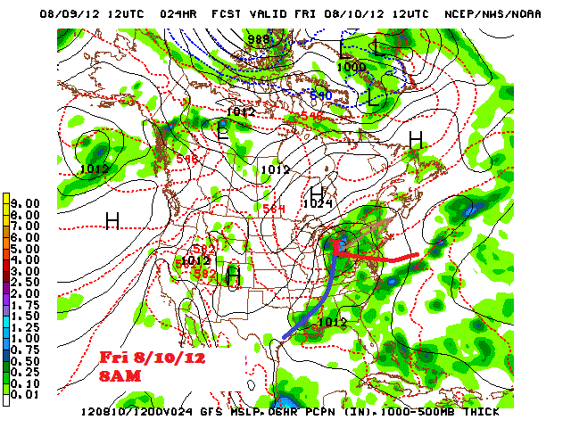
Cool weather and below normal temperatures with an abundance of rain is expected today into Friday with a gradual tapering to showers early in the weekend on Saturday. Sunday looks to be the best day of the lot with partly to mostly sunny skies and temperatures closer to normal with readings climbing back up to around 80.

This type of weather has not been seen since the first week of June and even then; it was not as wet and temperatures were closer to normal for that time. The current stretch of cool weather will contain high temperatures from the mid 60s to mid 70s through Saturday; or about 7 to 15 degrees below the normal high temperatures, depending on the day and location across Southeast Lower Michigan. The "lousiest" of the weather in regards to cool and wet conditions will encompass the region today into mid-day Saturday.

Surface Map


 Rainfall estimates


It wasn't too long ago many residents of Southeast Lower Michigan were dreaming of a cool and wet period with day after day of hot and dry weather...so now it's here and we could use it. Though the rains have picked up lately; dry to drought conditions still prevail over much of the region and worsen to the south /Map -3/. While the rain may spoil some plans; it is a blessing for the landscape and vegetation.


The estimated amounts of rain needed across the country to alleviate the drought as of early August is astounding (see map below). Of course; ideally this would be over an extended period of time. You certainly wouldn't want some of this rain in a couple of days or even weeks...or major flooding would occur!


Making weather fun while we all learn,
Bill Deedler - SEMI_WeatherHistorian