 | |
| Dedicated to Beloved Family Member: Mac: 9/14/98-6/26/16 |
The worst of the summer in Southeast Lower Michigan in many people's opinion of the season has been the dry weather; particularly if a one's a farmer, garden or owns a garden or landscape business. Thus far this summer /June/, we've generally had less than half the normal rainfall across the land. Of course, what makes matters worse is that May's average rainfall again, was also around a half or less of the normal. And, that is still not the extent of it; the rainfall since the start of this growing season /April/ has been in notably deficit with most areas receiving only 50 - 60% of the normal rain. See the chart below.
There is a chance of some rain overnight after midnight; so the June stats should remain the same as departures account for no rain through midnight.
Growing Season 2016 Precipitation
Adding to the dryness, June's warm temperatures have been normal to slightly above (about a degree or two).
That may be surprising since we've had some hot days in June. The main reason the average temperatures haven't been even warmer is that the dry weather allowed readings overnight to fall-off more appreciably. Humidity levels have been generally somewhat lower than normal for many summer nights. Therefore, our daily diurnal temperature variances have been larger on average - a bit more typical of weather experienced in the Great Plains.
Because of a wet late winter and early spring /Mar/, the overall aridity of the region is still more surface based than deeply based. However; this offers no solace to plants and crops that normally have shallower roots than the deeply rooted ones.
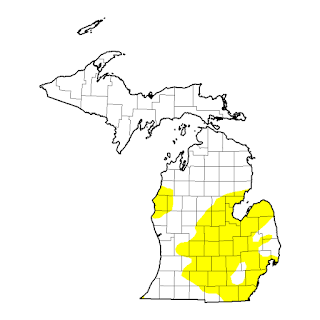
Drought Map and link for the Midwest and Michigan
Midwest and lower Ohio Valley
Highly variable rainfall was noted over the region’s Abnormally Dry (D0) and Moderate Drought (D1) areas. Relatively narrow swaths of moderate to heavy rain (1-4 inches, locally more) resulted in reductions of D0 and D1 coverage, most notably from Ohio into east-central Iowa. Conversely, D0 was increased over central and southern Michigan, where 60-day rainfall has totaled 50 to 70 percent of normal. Topsoil moisture in Michigan was rated 60 percent short to very short as of June 26 by USDA-NASS, a 13-point jump from last week and 57 percentage points higher than a year ago. While state-wide net gains were noted in soil moisture (percent short to very short decline week to week) from Missouri into Ohio, D1 was increased in southeastern Iowa and northeastern Missouri to reflect 60-day rainfall near or below half of normal. In the western-most Corn Belt, D1 was introduced in south-central Nebraska where 60-day rainfall was likewise less than 50 percent of normal.http://droughtmonitor.unl.edu/Home/StateDroughtMonitor.aspx?MI
Ok then; Why the dryness??
The pattern expected for the summer of roller-coaster temperatures resulting from conflicting air masses has been strong as forecasted but most storms and rainfall resulting from it has been along and south of the southern border of Michigan. Add to this; timing of frontal passages and a occasionally capped atmosphere (too warm aloft) which inhibited storm growth has resulted in the dryness of much of Southeast Lower Michigan.
Note the big difference in rainfall the past month along and just to the south of the region and further west (resulting in some sharp contrasting differences in short distances)!
Again; there is a chance of some rain overnight after midnight but then much of the holiday weekend looks dry. Latest models have a system moving where else, just south of Southeast Lower Michigan on July 4th. Any changes, I'll update our chances.


